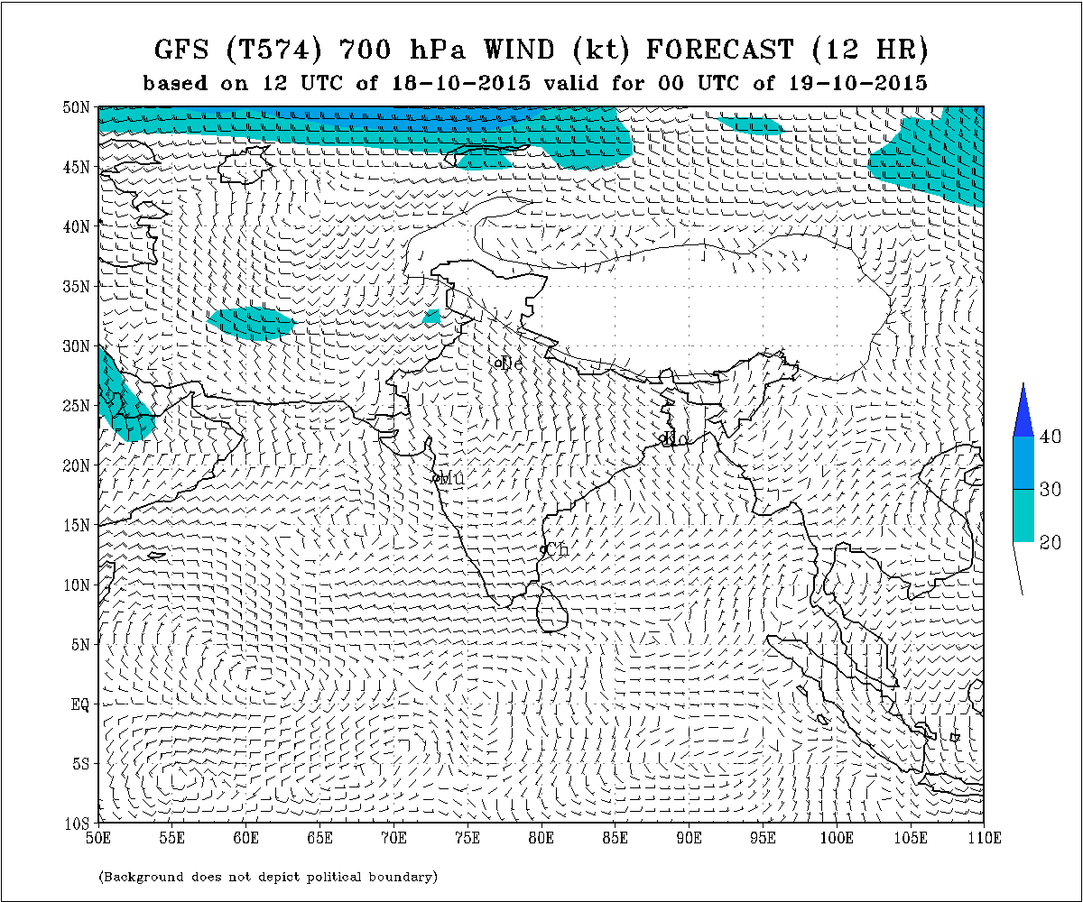
Current Weather Conditions on 19th October 2015 @ 8.00 am. IST
The Western Disturbance as an Upper Air Cyclonic Circulation over Northeast Afghanistan & neighborhood extending up to 3.1 km above mean sea level with a trough aloft roughly along Long. 60.0°E and North of Lat. 25.0°N persists.
There is an Upper Air Cyclonic Circulation South of Lakshdweep at 5 N. extending from 1.5 Km. to 3.1 km above sea level tilting Southwards with height.
There is also an Upper Air Cyclonic Circulation at 3.1 km above sea level over Eastcentral Arabian Sea west of Goa & Konkan Coast.
IMD GFS (T574) 700 hPa Wind Forecast Valid 00 UTC on 19-10-2015
Forecast: 19th October to 25th October 2015
Saurashtra, Gujarat & Kutch:
The Maximum Temperature is expected to remain above normal by 1 to 2 C over many places of Saurashtra, Gujarat & Kutch today the 19th October. The Maximum Temperature is expected to decline by 1 to 2 C and will be normal or slightly above normal during the rest of the forecast period.
The humidity at 700 hPa level ( 3.1 km.above sea level) will be high. Atmospheric instability is expected from 22nd October till the end of the forecast period. Partly cloudy on a few days during the forecast period. Wind will be between West, Northwest & North changing frequently. Stray showers expected on few days between 22nd to 25th October.
North India:
Due to the effects of Western Disturbance there will be rain in Jammu & Kashmir and nearby areas and Snowfall over the hilly areas of Jammu & Kashmir on 19th/20th and again on 24th/25th October.
Please use your correct email address for comments on this website, else comments will not be published. Reply confirmation if you receive an email from this website.
અપડેટ તારીખ 19 ઓક્ટોબર સવારે 8.00 કલાકે:
3.1 કિમી ના લેવલે વેસ્ટર્ન ડીસ્ટર્બન્સ ઊત્તર પૂર્વ અફઘાનિસ્તાન અને આસપાસ ના વિસ્તાર માં છે. તેના અનૂસંધાને ટ્રફ Long. 60.0°E and North of Lat. 25.0°N ઉપર છે.
એક UAC લક્ષદ્વીપ ની દક્ષીણે છે જે 1.5 કિમી થી 3.1 કિમી ના લેવેલે છે અને તે ઊંચાઈ સાથે દક્ષીણ તરફ ઝુકાવ કરે છે.
એક બીજું UAC કોંકણ અને ગોવા થી પશ્ચિમે 3.1 કિમી ના લેવેલે મધ્ય પૂર્વ અરબી સમુદ્રમાં છે.
આગાહી: તારીખ 19 ઓક્ટોબર થી 25 ઓક્ટોબર
સૌરાષ્ટ્ર, ગુજરાત અને કચ્છ:
સૌરાષ્ટ્ર, ગુજરાત અને કચ્છ ના ઘણા સેન્ટરો માં મહત્તમ તાપમાન હજુ આજે પણ નોર્મલ થી 1 થી 2 C ઊંચું રહેશે. તારીખ 20 થી મહત્તમ તાપમાન માં ક્રમશ રાહત રહેશે અને બાકી ના આગાહી સમય માં નોર્મલ અથવા એકાદ ડીગ્રી ઊંચું રહેશે.
700 hPa ના લેવેલે (3.1 કિમી ની ઊંચાયે ) ભેજ નું પ્રમાણ વધુ રહેશે. તારીખ 22 ઓક્ટોબર થી બાકી ના આગાહી સમય માં (25 તારીખ સુધી ) ઉપલા લેવેલે વાતાવરણ માં અસ્થિરતા રહેશે. અમૂક દિવસે છુટા છવાયા વાદળો પણ થશે. તેથી તારીખ 22 થી 25 દરમિયાન કોઈ કોઈ દિવસે છાંટા છૂટી ની શક્યતા છે. પવન પશ્ચિમ, ઊત્તર પશ્ચિમ અને ઊત્તર બાજુ થી રહેશે જે અવાર નવાર ફરતો રહેશે.
ઊત્તર ભારત:
વેસ્ટર્ન ડીસ્ટર્બન્સ ની અસર થી તારીખ 19-20 ના જમ્મુ કાશ્મીર અને લાગુ વિસ્તારો માં વરસાદ અને પહાડી વિસ્તારો માં બરફ વર્ષા થશે. તેવીજ રીતે તારીખ 24-25 ના પણ જમ્મુ કાશ્મીર અને લાગુ વિસ્તારો માં વરસાદ અને પહાડી વિસ્તારો માં બરફ વર્ષા થશે.
Comment karva maate Tamaru Email address hoi te lakho.
Khota email address vara comment prasiddh nahi thaay.
Ahi thi jo tamone email aave toe reply karo etle comment prasiddh thashe.