Latest Update: on 26th October 2015 @ 8.00 pm. IST
The Low Pressure area over the Southeast Arabian Sea has now become a Well Marked Low Pressure. This System is being monitored as 94A.INVEST.
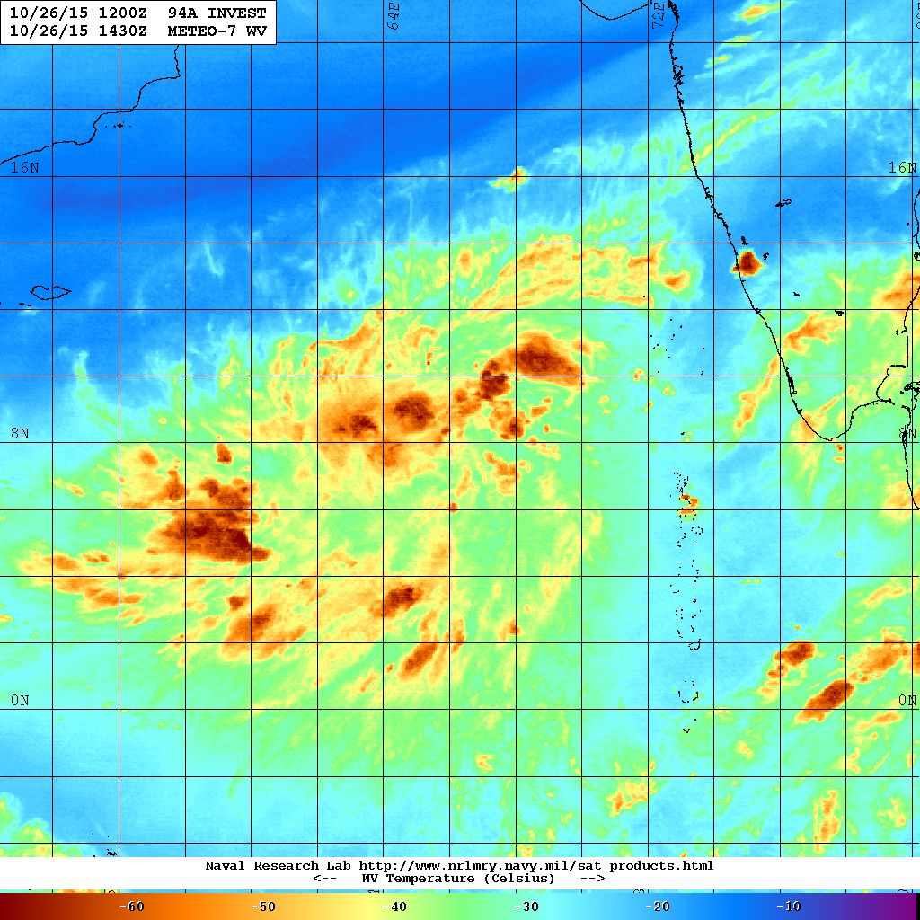
94A.INVEST over Southeast Arabian Sea Location 7.5 N. & 66.3 E. 25 knots with 1004 millibar Central Pressure NRL WV Satellite Image on 26th October @ 1430 UTC
Low Pressure area over the Southwest Bay of Bengal is yet getting organized. This System is being monitored as 93B.INVEST.
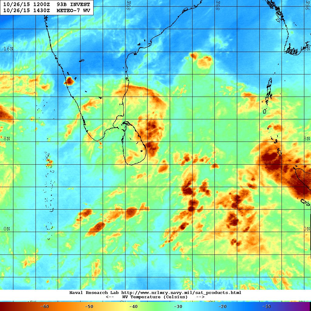
93B.INVEST over Southwest Bay of Bengal Location 6.8 N. & 82.7 E. 20 knots with 1007 millibar Central Pressure NRL WV Satellite Image on 26th October @ 1430 UTC
The Western Disturbance as an Upper Air Cyclonic Circulation over North Pakistan & neighborhood extending up to Mid-Tropospheric level with trough aloft along Long.68.0°E and North of Latitude 20.0°N. An induced Upper Air Cyclonic Circulation over North Rajasthan & neighborhood extending up to 2.1 km above mean sea level persists.
Forecast: 26th to 31st October 2015
Both GSF and ECMWF 00 UTC run shows that the Arabian Sea System will be stronger than the BOB System. Now there better agreement between the two forecast models. The BOB System is placed North of Chennai by GSF while ECMWF places the System South of Chennai on 30th October 1200 UTC. However, the 0600 UTC GSF again differs its outcome for the BOB System.
The Western Disturbance will give heavy snowfall for Jammu & Kashmir and hilly regions of North India and rain for the plains of North Indian States till 26th October.
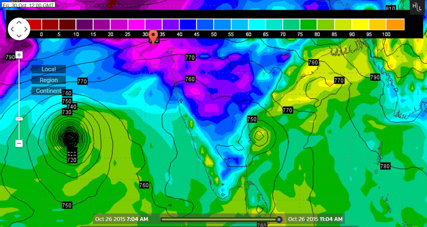
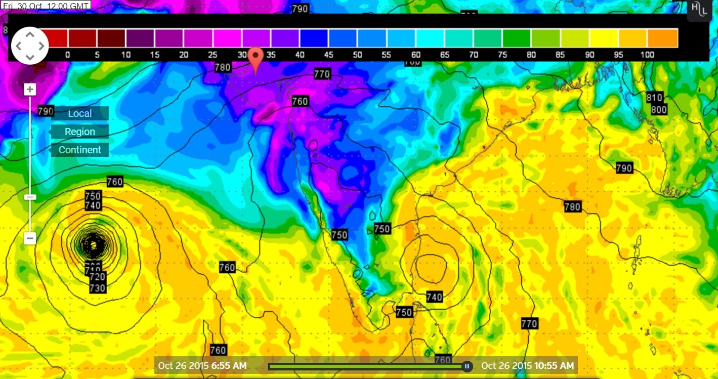
Wunderground Map showing System location on GSF 925 hPa
Forecast run 0000 UTC on 26th October 2015 valid 30th October 2015 @ 1200 UTC
Wunderground Map showing System location on GSF 925 hPa
Forecast run 0600 UTC on 25th October 2015 valid 30th October 2015 @ 1200 UTC
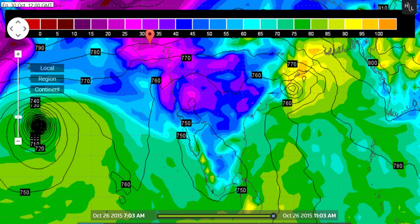
Wunderground Map showing System location on ECMWF 925 hPa
Forecast run 00 UTC on 26th October 2015 valid 30th October 2015 @ 1200 UTC
Forecast: Saurashtra, Gujarat & Kutch: 26th October to 31st October
No direct effect from Bay of Bengal System and also not from the Arabian Sea System during the forecast period till 31st October. The Arabian Sea System is going Northwest towards Oman. However, it will be monitored for any change in track. The weather is expected to be dry on most days. The wind is expected to be from North or Northeast on most days during the forecast period.
અપડેટ 26 ઓક્ટોબર 2015 રાત્રે 8.00 કલાકે:
દક્ષીણ પૂર્વ અરબી સમુદ્ર નું લો પ્રેસર મજબૂત બની હવે વેલ માર્કડ લો પ્રેસર માં પરિવર્તિત થયું છે.
દક્ષીણ પશ્ચિમ બંગાળની ખાડી માં લો પ્રેસર હજુ મજબૂત નથી થયું.
અરબી સમુદ્ર ની સીસ્ટમ હાલ ઊત્તર પશ્ચિમ તરફ ગતિ કરશે એટલે ઓમાન તરફ જાય છે. આમાં કઈ ફેર ફાર હશે તો અપડેટ થશે.
વેસ્ટર્ન ડીસ્ટર્બન્સ ની અસર થી હજુ આજનો દિવસ સુધી જમ્મુ અને કાશ્મીર અને ઊત્તર ભારત ના પહાડી વિસ્તારો માં હિમ વર્ષા તેમજ મેદાની વિસ્તારો માં વરસાદ થશે. આવતી કાલ થી આની અસર ઓછી થશે. જોકે એક બે દિવસ એમ.પી. આસપાસ અસર રહેશે.
સૌરાષ્ટ્ર, કચ્છ અને ગુજરાત: 26 ઓક્ટોબર થી 31 ઓક્ટોબર 2015
મુખ્યત્વે વાતાવરણ સુકું અને મહત્તમ દિવસે પવન હવે ઊત્તર અને ઊત્તર પૂર્વ તરફ થી ફૂંકાશે. આગાહી સમય દરમિયાન મહત્તમ તાપમાન માં આગલા પાંચેક દિવસ કરતા 1 થી 2 ડીગ્રી રાહત રહેશે.
Weather Forecast In Akila Daily Dated 27th October 2015
Scroll Up