Current Weather Conditions on 29th October 2015 @ 8.00 pm. IST
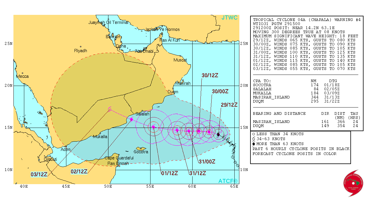
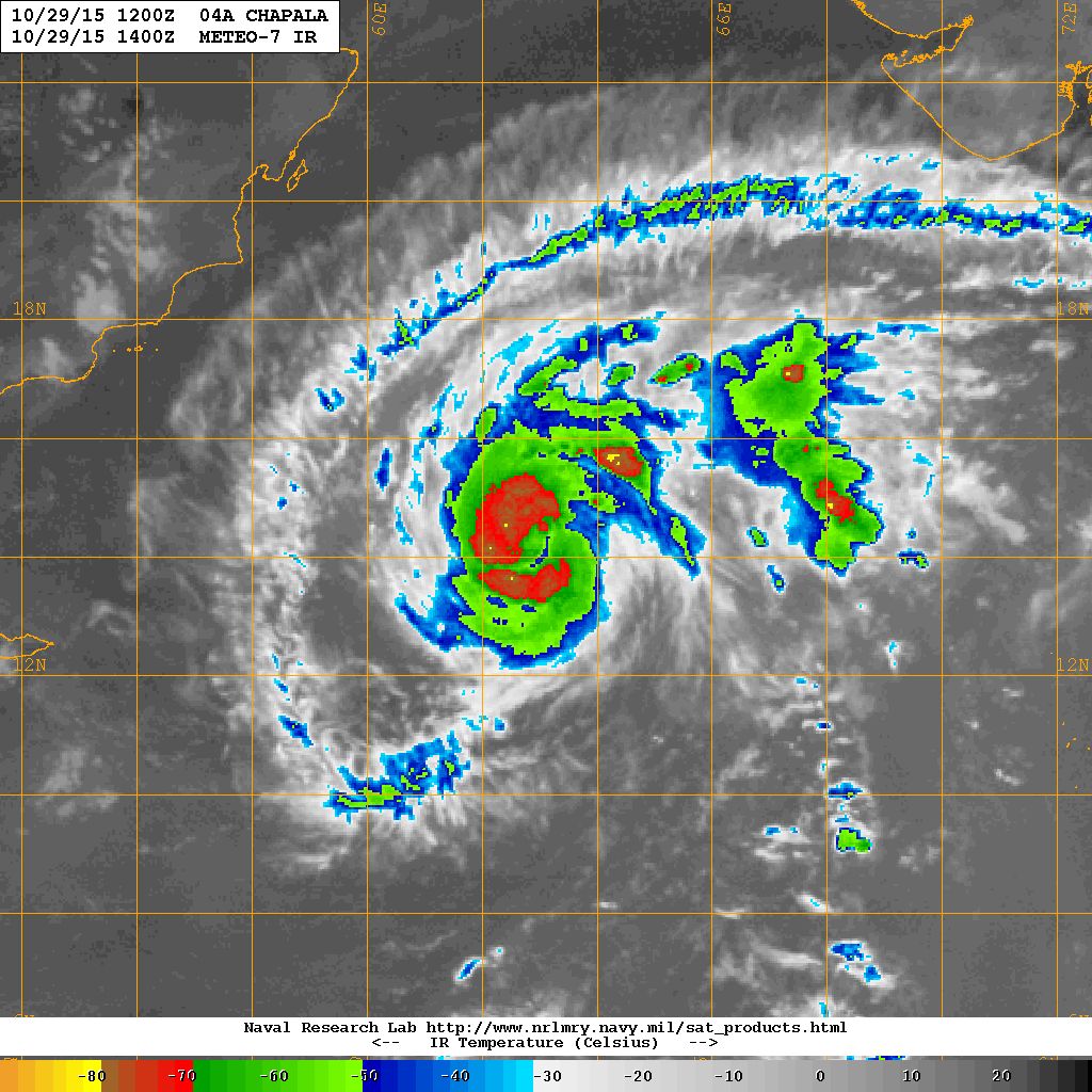
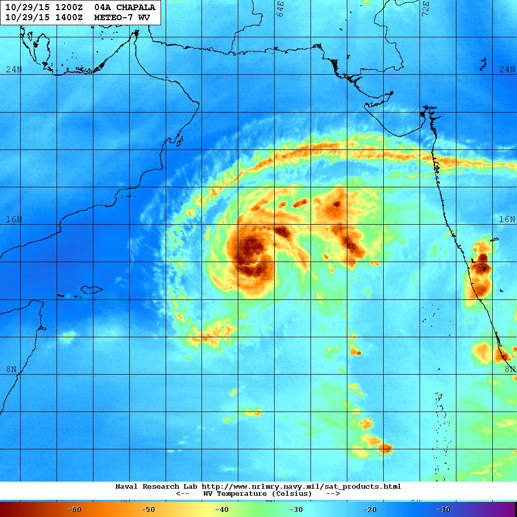
As per NRL: 04A (CHAPALA) over the Westcentral Arabian Sea is located at 14.2°N & 63.1°E with winds of 65 knots & Central Pressure of 974 mb. on 29th October 2015 @ 1400 UTC.
1 knot= 1.85 km./hour
From JTWC:
JTWC Tropical Cyclone 04A (FOUR) Warning No. 4
NRL IR Satellite Image on 29th October 2015 @ 1400 UTC (07.30 pm. IST)
NRL Water Vapor Satellite Image on 29th October 2015 @ 1400 UTC (07.30 pm. IST)
The Cyclonic Storm “CHAPALA” is now over Westcentral Arabian Sea. As per International Weather Agencies the winds are blowing at 120 km./hour with gusts of 150 km/hour based on average winds on 1 minute basis as compared to IMD’s basis of 3 minute average wind speed. The System is expected to track towards Oman/Yemen next few days. The System expected to become a Severe Cyclonic Storm soon as per IMD/RSMC norms.
Forecast: Saurashtra, Gujarat & Kutch: 29th October to 3rd November 2015
In Gujarat the wind is expected to be from North, Northeast & then East on most days during the forecast period depending upon the location of the System. The weather is expected to be dry on most days. However, some peripheral clouding associated with the System has already come over Saurashtra & Gujarat and so it will be cloudy for few days.
Caution: Please refer/rely on IMD/RSMC Bulletins/Advisories for Storms & Weather related matter.
અપડેટ 29 ઓક્ટોબર 2015 રાત્રે 8.00 કલાકે:
અરબી સમુદ્ર વાળી સીસ્ટમ મજબૂત બની ને વાવાઝોડા માં પરિવર્તિત થઇ. આ વાવાઝોડા નું નામ છે “ચપલા” (“CHAPALA”). હજુ ટૂંક ટાઇમ માં આ સીસ્ટમ વધુ મજબૂત બની તીવ્ર વાવાઝોડા માં પરિવર્તિત થશે.
અરબી સમુદ્ર નું વાવાઝોડું ના પવનો ઇન્ટરનેસનલ એજન્સી મૂજબ 120 કિમી પ્રતિ કલાકે ફૂંકાય છે (1 મિનીટ ની શરેરાશ મૂજબ ) જે IMD 3 મિનીટ ની શરેરાશ મૂજબ માપે છે. આંચકા ના પવનો 150 કિમી ની ઝડપે ફૂંકાય છે (1 મિનીટ ની શરેરાશ મૂજબ ). અરબી સમુદ્ર ની સીસ્ટમ હાલ ઓમાન/યેમેન તરફ જાય છે. સીસ્ટમ સૌરાષ્ટ્ર તેમજ ગુજરાત થી ઘણી દૂર છે છતાં સીસ્ટમ ના પૂછડિયા વાદળો સૌરાષ્ટ્ર તેમજ દક્ષીણ ગુજરાત ઉપર થી પાસ થાય છે.
દક્ષીણ ભારત ના તમિલનાડુ, કેરલા, આંધ્ર પ્રદેશ અને કર્નાટકામાં ઊત્તર પૂર્વ ચોમાસું ગઈ કાલ થી બેસી ગયું છે.
દક્ષીણ પશ્ચિમ બંગાળની ખાડી માં લો પ્રેસર નબળું પડ્યું. હવે ફક્ત UAC છે .
સૌરાષ્ટ્ર, કચ્છ અને ગુજરાત: 29 ઓક્ટોબર થી 3 નવેમ્બર 2015
મુખ્યત્વે વાતાવરણ સુકું અને મહત્તમ દિવસે પવન હવે ઊત્તર અને ઊત્તર પૂર્વ અને ક્યારેક પૂર્વ તરફ થી ફૂંકાશે. આગાહી સમય દરમિયાન મહત્તમ તાપમાન માં આગલા પાંચેક દિવસ કરતા 1 થી 2 ડીગ્રી રાહત રહેશે. અરબી સમુદ્ર વાળી સીસ્ટમ સૌરાષ્ટ્ર ગુજરાત થી દૂર છે છતાં તેના પૂછડિયા વાદળો અમૂક દિવસે સૌરાષ્ટ્ર અને ગુજરાત ઉપર થી પસાર થશે.
સાવચેતી:
સ્ટોર્મ કે હવામાન અંગે ની માહિતી માટે ભારતીય હવામાન ખાતા/ગવર્મેન્ટ ના બુલેટીન/સુચના પર નિર્ભર રહેવું.
Weather Forecast In Akila Daily Dated 29th October 2015