Current Weather Conditions on 28th October 2015 @ 8.00 pm. IST
Northeast monsoon rains have commenced over Tamilnadu, Kerala and adjoining areas of Andhra Pradesh and Karnataka on the 28th October 2015.
IMD has issued a Bulletin No.: ARB04/2015/02
Time of issue: 1930 hours IST
Dated: 28.10.2015
Sub: Deep Depression over Eastcentral and adjoining Westcentral and South Arabian Sea.
The Depression over southeast Arabian Sea and adjoining areas of southwest and central Arabian Sea moved north-northwestwards and intensified into a Deep Depression and lay centered at 1730 hrs IST of today, the 28th October 2015 over east central and adjoining westcentral and south Arabian Sea near Latitude 12.5°N and longitude 64.7°E, about 1350 km southwest of Mumbai and about 1250 km southeast of Salalah (Oman). It would move north-northwestwards and intensify into a Cyclonic Storm during next 24 hours. It would then move westwards towards Yemen and adjoining Oman coast. As the system is expected to move away from the Indian coast, no adverse weather is expected along and off west coast of India. However, the fishermen over Lakshadweep area are advised to be cautious while venturing into the sea during next 24 hours.
For further details click link below.
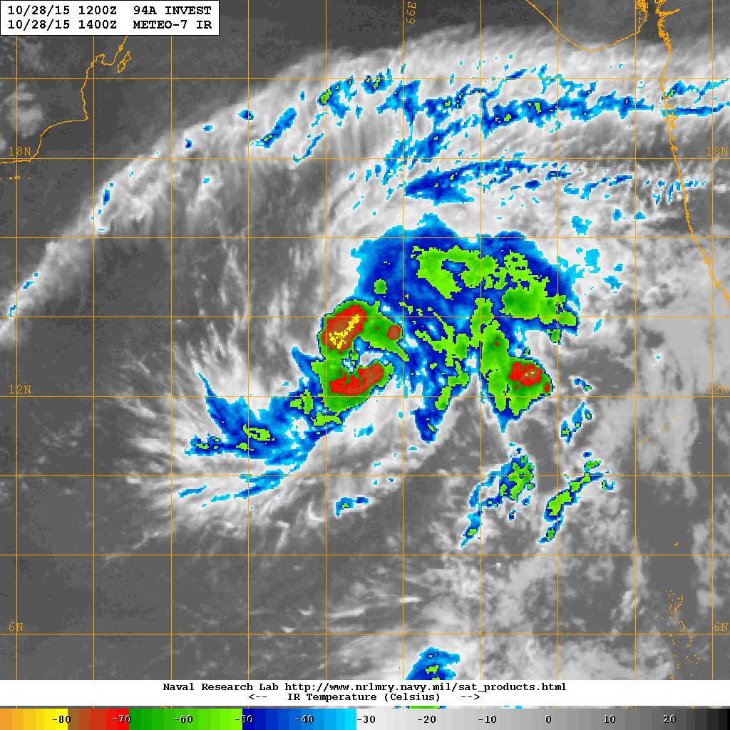
As per NRL: 94A.INVEST over the East Central Arabian Sea is located at 12.8°N & 65.0°E with 30 knots & 1000 mb. on 28th October 2015 @ 1200 UTC.
( Deep Depression as Per IMD)
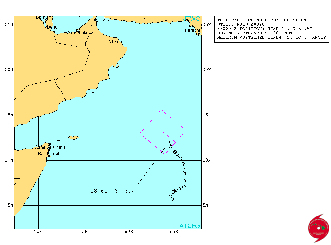
From JTWC:
WTIO21 PGTW 280700
MSGID/GENADMIN/JOINT TYPHOON WRNCEN PEARL HARBOR HI//
SUBJ/TROPICAL CYCLONE FORMATION ALERT//
RMKS/
1. FORMATION OF A SIGNIFICANT TROPICAL CYCLONE IS POSSIBLE WITHIN
105 NM EITHER SIDE OF A LINE FROM 12.0N 65.1E TO 14.3N 62.4E
WITHIN THE NEXT 06 TO 24 HOURS. AVAILABLE DATA DOES NOT JUSTIFY
ISSUANCE OF NUMBERED TROPICAL CYCLONE WARNINGS AT THIS TIME.
WINDS IN THE AREA ARE ESTIMATED TO BE 25 TO 30 KNOTS. METSAT
IMAGERY AT 280600Z INDICATES THAT A CIRCULATION CENTER IS LOCATED
NEAR 12.1N 64.5E. THE SYSTEM IS MOVING NORTHWARD AT 06 KNOTS.
2. REMARKS:
   THE AREA OF CONVECTION PREVIOUSLY LOCATED NEAR 10.7N 65.3E, IS NOW
LOCATED NEAR 12.1N 64.5E, APPROXIMATELY 583 NM EAST OF SOCOTRA
ISLAND, YEMEN. ANIMATED MULTISPECTRAL SATELLITE IMAGERY (MSI) SHOWS A
SLOWLY CONSOLIDATING SYSTEM WITH FORMATIVE BANDS WRAPPING INTO A
DEFINED LOW LEVEL CIRCULATION CENTER. THE SYSTEM IS LOCATED IN A
CONDUCIVE ENVIRONMENT WITH DUAL CHANNEL OUTFLOW WITH A STRONG
POLEWARD BIAS, LOW (05-10 KNOT) VERTICAL WIND SHEAR (VWS) AND SEA
SURFACE TEMPERATURES ABOVE 29 CELSIUS. GLOBAL MODELS INDICATE
SIGNIFICANT DEVELOPMENT OF THIS DISTURBANCE OVER THE NEXT 2 DAYS AS
IT TRACKS POLEWARD AND THEN WESTWARD INTO AN AREA OF DECREASING VWS
AND IMPROVED POLEWARD OUTFLOW. MAXIMUM SUSTAINED SURFACE WINDS ARE
ESTIMATED AT 25 TO 30 KNOTS. MINIMUM SEA LEVEL PRESSURE IS ESTIMATED
TO BE NEAR 1003 MB. THE POTENTIAL FOR THE DEVELOPMENT OF A
SIGNIFICANT TROPICAL CYCLONE WITHIN THE NEXT 24 HOURS IS HIGH.
3. THIS ALERT WILL BE REISSUED, UPGRADED TO WARNING OR CANCELLED BY
290700Z.//
NNNN
JTWC Map Showing Forecast Track For 94A.INVEST (TCFA)
(Deep Depression as Per IMD)
NRL IR Satellite Image on 28th October 2015 @ 1400 UTC (07.30 pm. IST)
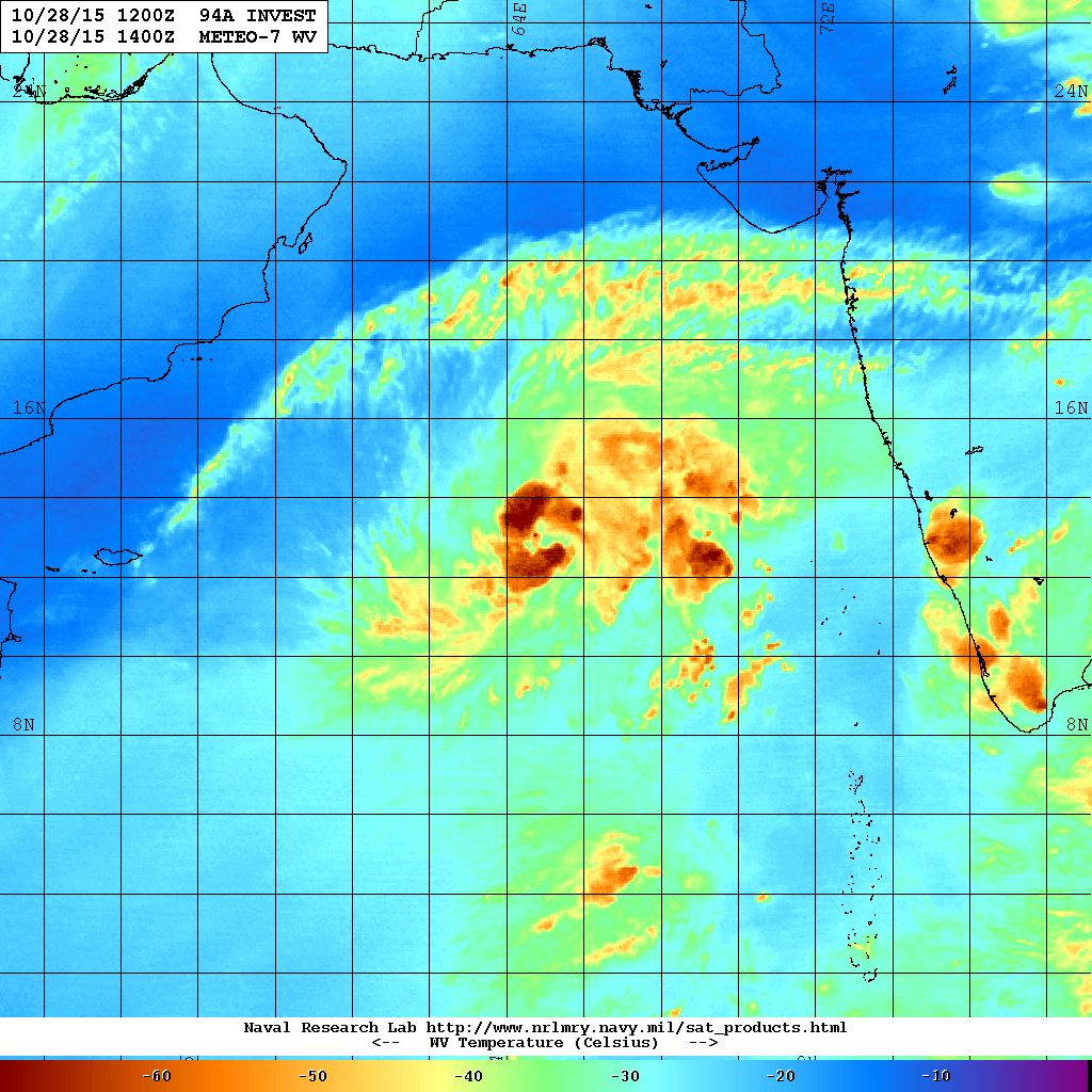
NRL Water Vapor Satellite Image on 28th October 2015 @ 1400 UTC (07.30 pm. IST)
Forecast: Saurashtra, Gujarat & Kutch: 28th October to 2nd November 2015
The Arabian Sea System is going Northwest towards Oman/Yemen. The wind is expected to be from North or Northeast on most days during the forecast period depending upon the location of the System. The weather is expected to be dry on most days. However, some peripheral clouding associated with the System will come close to Saurashtra & Gujarat and so it could be cloudy on some days.
અપડેટ 28 ઓક્ટોબર 2015 રાત્રે 8.00 કલાકે:
દક્ષીણ પૂર્વ અરબી સમુદ્ર નું ડીપ્રેસન વધુ મજબૂત બની ડીપ ડીપ્રેસન માં પરિવર્તિત થયું છે. હાલ મધ્ય પૂર્વ અરબી સમુદ્ર અને લાગુ મધ્ય પશ્ચિમ અરબી સમુદ્ર આસપાસ છે.
દક્ષીણ પશ્ચિમ બંગાળની ખાડી માં લો પ્રેસર હજુ મજબૂત નથી થયું.
અરબી સમુદ્ર ની સીસ્ટમ હાલ ઊત્તર પશ્ચિમ તરફ ગતિ કરશે અને ત્યાર બાદ પશ્ચિમ ઊત્તર પશ્ચિમ એટલે ઓમાન/યેમેન તરફ જાય છે. હજુ આ સીસ્ટમ મજબૂત થશે. સીસ્ટમ સૌરાષ્ટ્ર તેમજ ગુજરાત થી 1000 કિમી દૂર છે છતાં સીસ્ટમ ના પૂછડિયા વાદળો સૌરાષ્ટ્ર તેમજ દક્ષીણ ગુજરાત થી નજીક છે.
દક્ષીણ ભારત ના તમિલનાડુ, કેરલા, આંધ્ર પ્રદેશ અને કર્નાટકામાં ઊત્તર પૂર્વ ચોમાસું આજ થી બેસી ગયું છે.
સૌરાષ્ટ્ર, કચ્છ અને ગુજરાત: 26 ઓક્ટોબર થી 2 નવેમ્બર 2015
મુખ્યત્વે વાતાવરણ સુકું અને મહત્તમ દિવસે પવન હવે ઊત્તર અને ઊત્તર પૂર્વ તરફ થી ફૂંકાશે. આગાહી સમય દરમિયાન મહત્તમ તાપમાન માં આગલા પાંચેક દિવસ કરતા 1 થી 2 ડીગ્રી રાહત રહેશે. અરબી સમુદ્ર વાળી સીસ્ટમ સૌરાષ્ટ્ર ગુજરાત થી દૂર છે છતાં તેના પૂછડિયા વાદળો અમૂક દિવસે સૌરાષ્ટ્ર અને ગુજરાત ઉપર થી પસાર થશે.
Caution:
Please refer/rely on IMD/RSMC Bulletins/Advisories for Storms & Weather related matter.
સાવચેતી:
સ્ટોર્મ કે હવામાન અંગે ની માહિતી માટે ભારતીય હવામાન ખાતા/ગવર્મેન્ટ ના બુલેટીન/સુચના પર નિર્ભર રહેવું.