Current Weather Conditions on 19th October 2015 @ 8.00 am. IST
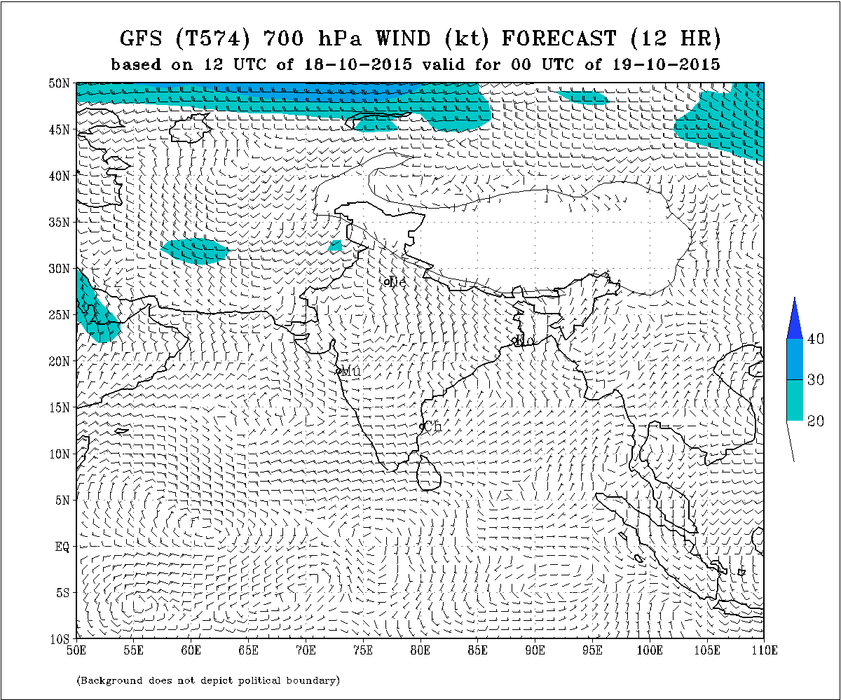
The Western Disturbance as an Upper Air Cyclonic Circulation over Northeast Afghanistan & neighborhood extending up to 3.1 km above mean sea level with a trough aloft roughly along Long. 60.0°E and North of Lat. 25.0°N persists.
There is an Upper Air Cyclonic Circulation South of Lakshdweep at 5 N. extending from 1.5 Km. to 3.1 km above sea level tilting Southwards with height.
There is also an Upper Air Cyclonic Circulation at 3.1 km above sea level over Eastcentral Arabian Sea west of Goa & Konkan Coast.
IMD GFS (T574) 700 hPa Wind Forecast Valid 00 UTC on 19-10-2015
Forecast: 19th October to 25th October 2015
Saurashtra, Gujarat & Kutch:
The Maximum Temperature is expected to remain above normal by 1 to 2 C over many places of Saurashtra, Gujarat & Kutch today the 19th October. The Maximum Temperature is expected to decline by 1 to 2 C and will be normal or slightly above normal during the rest of the forecast period.
The humidity at 700 hPa level ( 3.1 km.above sea level) will be high. Atmospheric instability is expected from 22nd October till the end of the forecast period. Partly cloudy on a few days during the forecast period. Wind will be between West, Northwest & North changing frequently. Stray showers expected on few days between 22nd to 25th October.
North India:
Due to the effects of Western Disturbance there will be rain in Jammu & Kashmir and nearby areas and Snowfall over the hilly areas of Jammu & Kashmir on 19th/20th and again on 24th/25th October.
Please use your correct email address for comments on this website, else comments will not be published. Reply confirmation if you receive an email from this website.
અપડેટ તારીખ 19 ઓક્ટોબર સવારે 8.00 કલાકે:
3.1 કિમી ના લેવલે વેસ્ટર્ન ડીસ્ટર્બન્સ ઊત્તર પૂર્વ અફઘાનિસ્તાન અને આસપાસ ના વિસ્તાર માં છે. તેના અનૂસંધાને ટ્રફ Long. 60.0°E and North of Lat. 25.0°N ઉપર છે.
એક UAC લક્ષદ્વીપ ની દક્ષીણે છે જે 1.5 કિમી થી 3.1 કિમી ના લેવેલે છે અને તે ઊંચાઈ સાથે દક્ષીણ તરફ ઝુકાવ કરે છે.
એક બીજું UAC કોંકણ અને ગોવા થી પશ્ચિમે 3.1 કિમી ના લેવેલે મધ્ય પૂર્વ અરબી સમુદ્રમાં છે.
આગાહી: તારીખ 19 ઓક્ટોબર થી 25 ઓક્ટોબર
સૌરાષ્ટ્ર, ગુજરાત અને કચ્છ:
સૌરાષ્ટ્ર, ગુજરાત અને કચ્છ ના ઘણા સેન્ટરો માં મહત્તમ તાપમાન હજુ આજે પણ નોર્મલ થી 1 થી 2 C ઊંચું રહેશે. તારીખ 20 થી મહત્તમ તાપમાન માં ક્રમશ રાહત રહેશે અને બાકી ના આગાહી સમય માં નોર્મલ અથવા એકાદ ડીગ્રી ઊંચું રહેશે.
700 hPa ના લેવેલે (3.1 કિમી ની ઊંચાયે ) ભેજ નું પ્રમાણ વધુ રહેશે. તારીખ 22 ઓક્ટોબર થી બાકી ના આગાહી સમય માં (25 તારીખ સુધી ) ઉપલા લેવેલે વાતાવરણ માં અસ્થિરતા રહેશે. અમૂક દિવસે છુટા છવાયા વાદળો પણ થશે. તેથી તારીખ 22 થી 25 દરમિયાન કોઈ કોઈ દિવસે છાંટા છૂટી ની શક્યતા છે. પવન પશ્ચિમ, ઊત્તર પશ્ચિમ અને ઊત્તર બાજુ થી રહેશે જે અવાર નવાર ફરતો રહેશે.
ઊત્તર ભારત:
વેસ્ટર્ન ડીસ્ટર્બન્સ ની અસર થી તારીખ 19-20 ના જમ્મુ કાશ્મીર અને લાગુ વિસ્તારો માં વરસાદ અને પહાડી વિસ્તારો માં બરફ વર્ષા થશે. તેવીજ રીતે તારીખ 24-25 ના પણ જમ્મુ કાશ્મીર અને લાગુ વિસ્તારો માં વરસાદ અને પહાડી વિસ્તારો માં બરફ વર્ષા થશે.
Comment karva maate Tamaru Email address hoi te lakho.
Khota email address vara comment prasiddh nahi thaay.
Ahi thi jo tamone email aave toe reply karo etle comment prasiddh thashe.
Sar mavthu 6
Email address sachu lakho.
Sir new uapdet kyare aapso?
Aaje ratre 11.30 pm.
Sir
Caylone thavanu che date.28/29
Keral ma baju ma che Caylone capala
And saurashtra ma varchad aavse k nay
Caylone etle Su ?
Baaki Cyclone ni vaat hoi toe tamo Chapala (capala nahi ) ani pahela pan mahino be mahina pahela two times vaat lai aviya hata.
Jyanthi avi mahiti mali hoi tyan poochho ke Saurashtra ma varsad avashe.
( ‘Champal’ oodey ne kyan padey ee kem khabar pade…. Arabi Samudra ma ke Bangad ni Khadi ma !!!!! )
Sir long delay
new update today ??
Kai hoi nahi toe su aapvu.
Update aaje ratre 11.30 pm.
Hello
We talk regarding 29oct to 6 Nov track change in both site perception outlook of India and uk site..now its showing towards arab and will not effect guj..am I right? System will enter in arab countries.?
That is the reason I don’t see anything more than 7 days ahead !
namste sir.
pak ma pohchel WD na vadado guj. ne asar karshe.(hal tal,adad,dungadi ne magfali nu kam pur josma chalu 6.)
Khas kai vandho ave evu nathi lagtu aapade.
Uttrgujarat ma mavtha ni aghahi che te sar kyre che
Western Disturbance ne hisabe 24-26 ma North India ma varsad chhe. Rajasthan sudhi asar thai. Tamoe ajathan najik chho. Bahu kai lagtu nathi.
Sir navu uapdet kyare aapso
saheb arbi samundra ma je vaddo che te aavta divsoma ma gujrat taraf gati kari sake????
Shakyata ochhi
Sarastra and kutch ma
Sar sky met kahe se ke 29 octomber to 5 november varsad no havy to very havy round aaav se tamne su lagese sar
Evu kai Skymete kahel hoi toe link moklo.
Sir tarikh 30 thi 5 sudhi jasdan taluka ma Varsad che tapas kari ne update apso.
There will be make UAC in central pakistan and adjoining rajsthan in next 48 hours as per IMD, is it affect on our State??
Sir new apdet kyare
28/29 ma arabisagar me lanka phase low batave 6 te apani baju avisake?
Tamoe joyu chhe ke Low bane chhe Lanka paase…. toe agadnu pan joiy levaay ne !
Sir have winter season kare avse
November thi farak dekhashe.
Sir have to bhagvan prathna kriye k have khama khama ne aavta varse sara A va Varsad thay
Sir thanks navi update mate
Sir arbi samudra ma fari majbut sistem bane che ta -26-27 na sachu che?
Samanya ritey …Koi pan Low Pressure thay athava thavanu hoi ane te Saurashtra/Gujarat/Kutch sudhi ponche te pahela 7 divas no time maley.
Badhi System Arabian Sea ma bane te Saurashtra/gujarat/Kutch ne asar kare evu na hoi.
Jasdan taluka na santhali gam ma 2 inch varsad
varsad magyo madyo nahi ne have varap pan kya magi madvani
Sir have nullschool vishe mahiti kiyare aapsho?
HA toonk time ma avashe.
Sir aaje keshod ane maliya baju atyare 5 vagye khub j ghata vadalo chhe…
Saheb Bhanvad ma mavthu 1 thi 1.5 inch varsad
Thodu hatu e pan bagadyu kudarat su kare khabar nahi
Parchuran chhata chhuti ni vaat hati 22 aaspas ane 24/25 ma.
hello sir,
perception outlook of india and weather online model uk, this two sites are showing heaving rainfall in gujarat mumbai from 1st nov may be depression like system so sir ten days in between koi pan system atyar na banti to hase ne near by south india which will come near guj or swift away to arab..?
please reply i am also giving you link of that sites
http://www.monsoondata.org/wx2/prec.html
http://www.weatheronline.co.uk/cgi-bin/expertcharts?LANG=en&MENU=0000000000&CONT=swas&MODELL=gfs&MODELLTYP=1&BASE=-&VAR=pr12&HH=276&ZOOM=0&WMO=&ARCHIV=0&RES=0
thank you.
Anything more than 7 days ahead has to be just kept in mind that the probability would be 50% and so has to be watched for few more days.
Sir 25 ta. Aju baju ma arabi ma system bane se ke nahi ? & te uttar tarf ave se ke nahi magafadi kadavi se to agotaru aedhan apava namabr vinti plz Ripley
Magafali kadhvani hoi toe raah na jovaay. Ghar begi karay. Athavadiya pachhi nu su hoi te khyaal nathi. Haal koi moto varsad nathi. Parchuran chhata chhuti kyank hoi.
Tamare nirnay tamari ritey levo.
namste sir,
satellite image ma vadado akar k uchay mathi kya adhare darshavata hase?
jamjodhpur NE ma aje sanje gajvij thay adaje 40km dur varsad hase.
sir aaje porbandar na ranavav ni aaspas na vistar ma zapata padya to aagla divaso ma zapata ni sakyata khari.
Sir varsad ni have sakyata che.
Chomasu vidaay lai lidhi chhe.
chhata chhuti ni shakyata 50% 50% chhe. Kai motu nathi.
SIR, HAVE SAURASHTRA MA MOTA VARSAD NI SAMBHAVNA LAGE CHE ?
aagahi samay ma evu kai nathi.
Good morning Sr je wd MA j uac Che te majbut thay and low bne to Gujrat MA koy vrsad ni skyata khari?
Ek WD pooru thayu thavama ane biju thoda divas ma chhe. North India ma asar kartu hoi. Gujarat ne Saurashtra ke Kutch ne fakt kyarek asar kare ane te pan samanya hoi.
Sir pls..direct ,link apone cola ne 850 mb ni amathi mare nathi thati pls….
http://www.monsoondata.org/wx/india.850.html
Westurn disturbance etle su thodi mahiti aapo
Western disturbance vishe avar navr ahi thi kahel chhe.
Iran Afghanistan ane Pakistan baju thi 3.1 KM thi 5.8 km ni oonchaye UAC Bharat oopar ..khas karine North India oopar ave tene WD kahe.
Siyadu varsadn WD ne hisabe hoi.
this will happen -Partly cloudy on a few days during the forecast period. Wind will be between West, Northwest & North changing frequently. Stray showers expected on few days between 22nd to 25th October.
Sir aaje keshod nu amaru GAM muliyasa ma sata hata.ane ukarat bov j 6.
sir, is there any chances of unseasonal rainfall in Bhavnagar district for next 3-5 days?
It has been clearly mentioned in the forecast. It is generalized forecast and so it may not be specific to Bhavnagar.
Sir what will happen due to atmospheric instability over gujarat?
It has been clearly given in the forecast.
Sir
Thandi salu thavama haji time lagse?
November thi chalu thashe.
Sir,chomasu jay etale commentaro pan ocha thay,,,
Thanks for new update
Sir thanks new update
Sir kale gir vistar ma kyak kyak zapta padya hata to su aje pan sakyata se
Khas lagtu nathi evu.