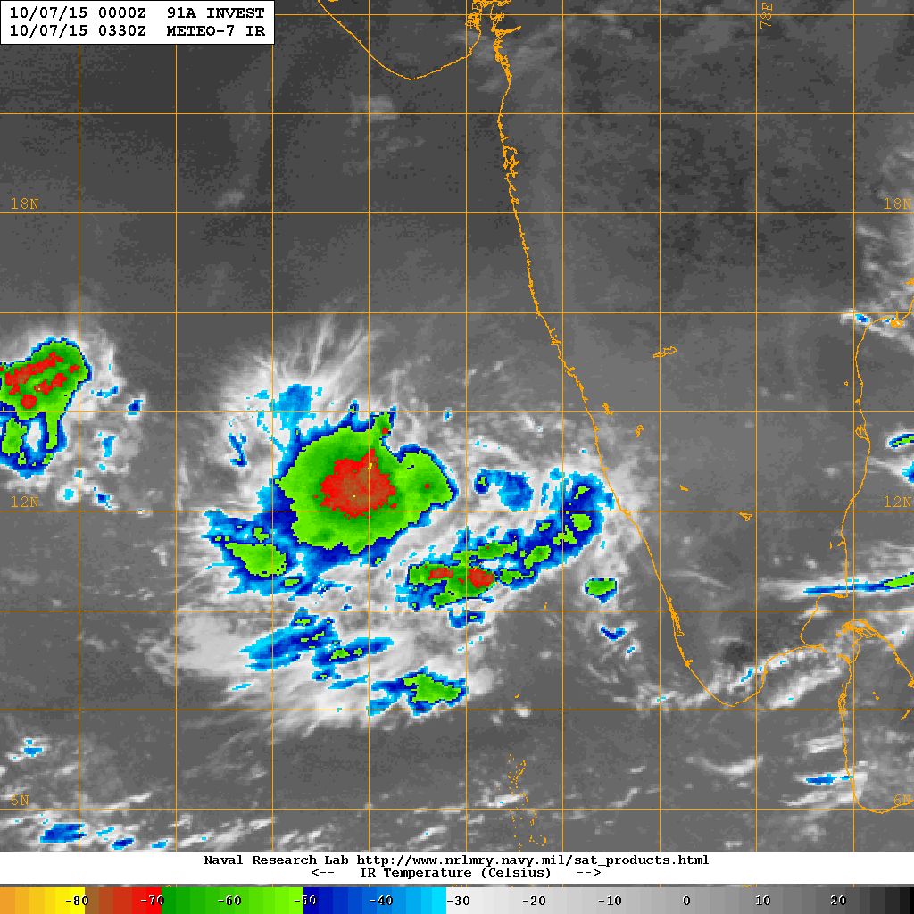
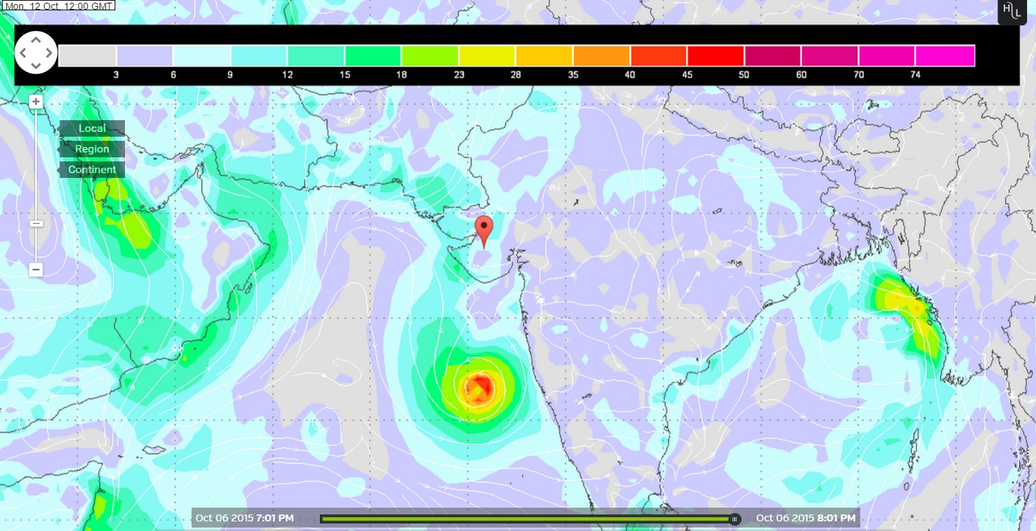
91A.INVEST over Eastcentral Arabian Sea Location 13.1N. & 71.8E. 20 knots with 1005 millibar Central Pressure on 7th October NRL IR Satellite Image @ 0330 UTC
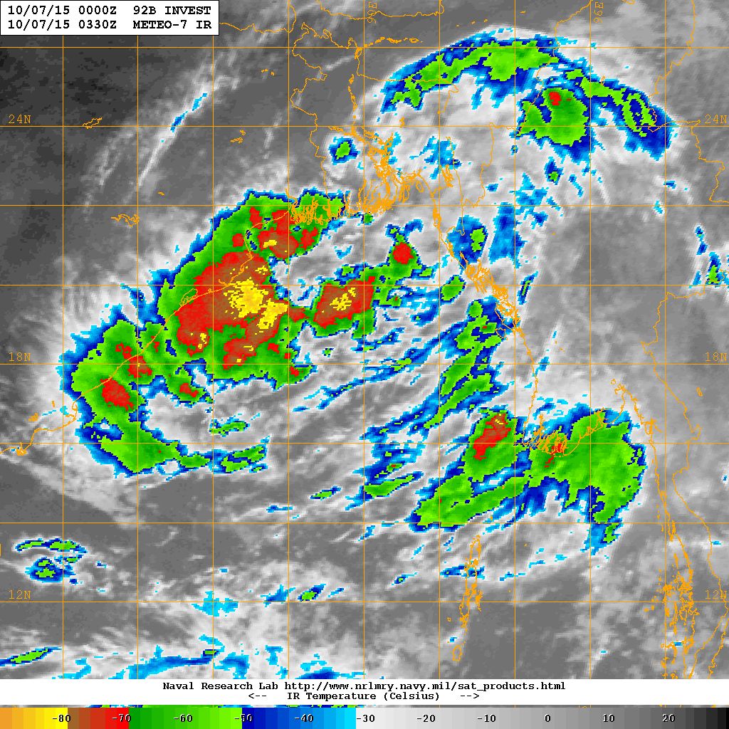
92B.INVEST over North Bay of Bengal Location Lat. 18.0 N. & 90.0 E. 15 knots with 1006 millibar Central Pressure on 7th October NRL IR Satellite Image @ 0330 UTC
Current Weather Conditions on 7th October 2015 @ 8.00 am. IST
The Southwest Monsoon has further withdrawn from some more parts of Bihar; remaining parts of Madhya Pradesh; some parts of Jharkhand, Chhattisgarh, Vidarbha, Madhya Maharashtra; some more parts of Gujarat state and North Arabian sea.
The withdrawal line of Southwest Monsoon now passes through Forbesganj, Ranchi, Raipur, Nagpur, Jalgaon, Veraval, Lat.21.0°N/Long. 65.0°E and Lat.21.0°N/Long. 60.0°E.
This means the Southwest Monsoon has withdrawn form most parts of Saurashtra except South coastal areas of Saurashtra from Veraval to Rajula. Similarly, Southwest Monsoon has withdrawn from all parts of Gujarat that are North of Surat.
IMD Map showing the Withdrawal of Southwest Monsoon till 6th October 2015.
The Upper Air Cyclonic Circulation is now over North Bay of Bengal & neighborhood extending upto 3.1 km above mean Sea levels. Under its influence, a Low Pressure area may form over that region by tomorrow.
An Upper Air Cyclonic Circulation has formed over Eastcentral Arabian Sea extending up to Mid-Tropospheric levels. Under its influence, a Low Pressure area may form over the same region by tomorrow.
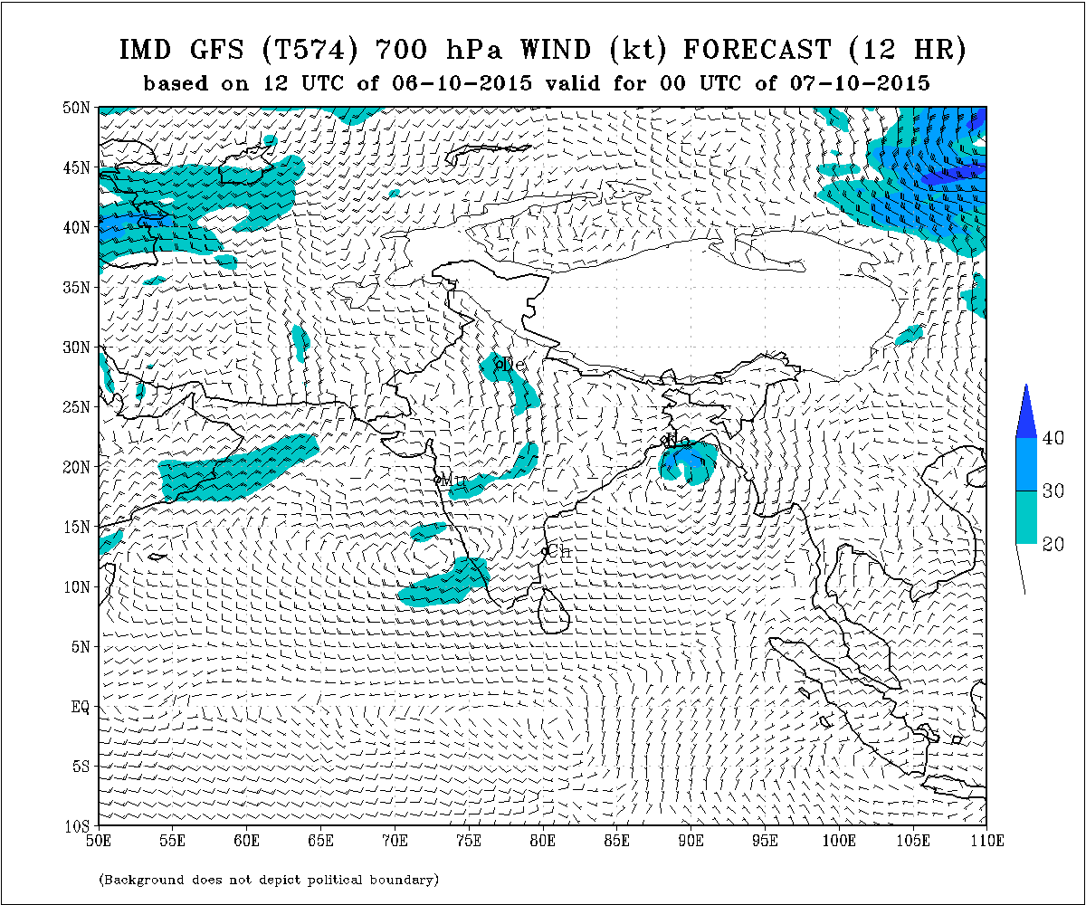
IMD 700 hPa Wind Forecast Valid 00 UTC 7th October 2015
Forecast: 7th October to 11th October 2015
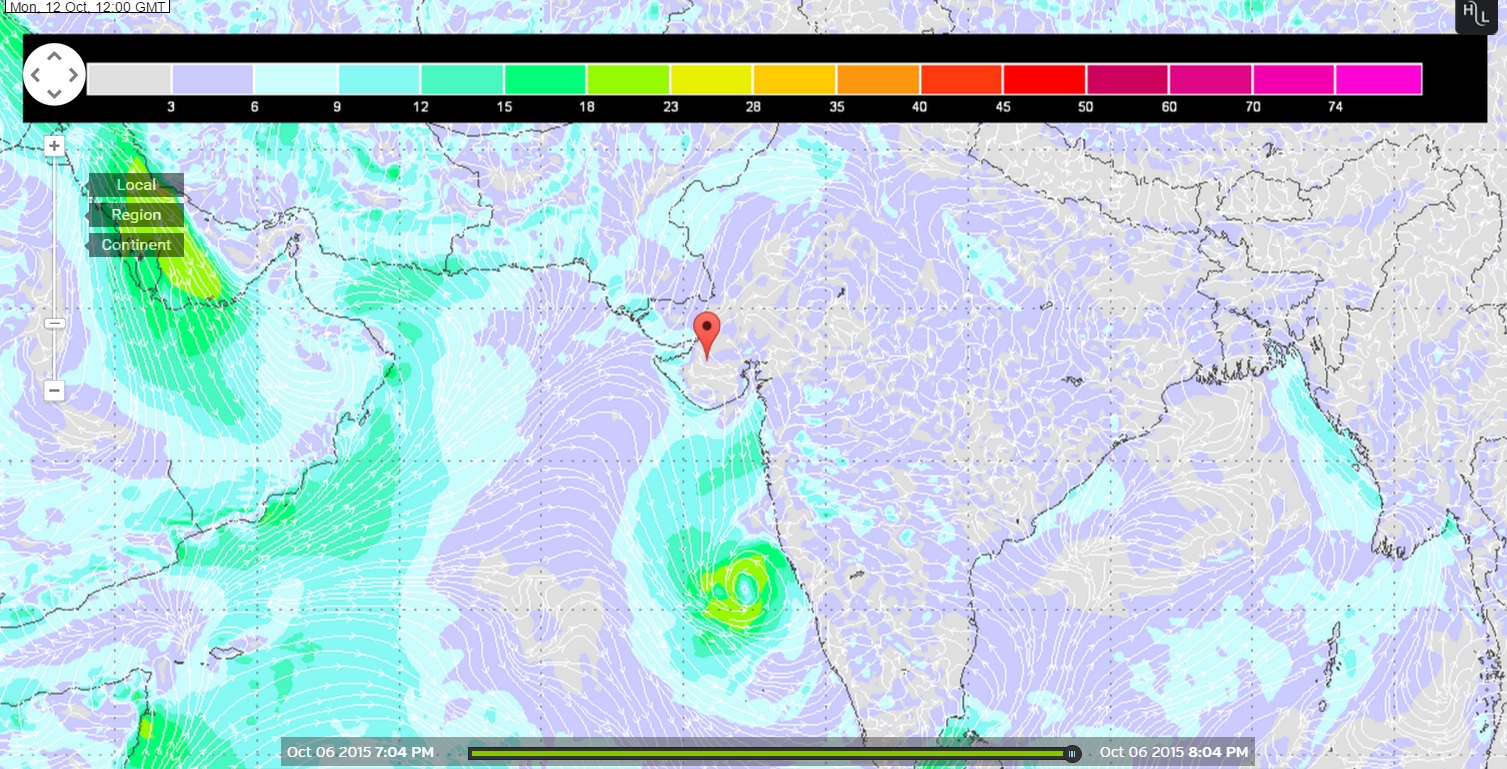
The expected Low Pressure System over the East Central Arabian Sea is forecast to track Northerly direction till 11th reaching 15 Degree North Latitude West of Goa.
Saurashtra, Gujarat & Kutch:
The Maximum Temperature is expected to remain above normal over many places of Saurashtra, Gujarat & Kutch till 9th October. Weather will be clear on most days during the forecast period with no chance of any meaningful rainfall. There is a possibility of clouding associated with the expected Low Pressure over the Eastcentral Arabian Sea to come near Saurashtra and Gujarat after 10th. System is expected to remain away from Saurashtra & Gujarat during the forecast period.
Wunderground ECMWF Surface Wind Map showing
Wind Direction and Speed knots (1 knot = 1.85 km./hour)
Location of System @ 1200 UTC on 12th October 2015
Wunderground GSF Surface Wind Map showing
Wind Direction and Speed knots (1 knot = 1.85 km./hour)
Location of System @ 1200 UTC on 12th October 2015
અપડેટ તારીખ 7 ઓક્ટોબર સવારે 8.00 કલાકે:
દક્ષીણ પશ્ચિમ ચોમાસુ સમગ્ર એમપી, તેમજ બિહાર ઝારખંડ, છતીશગઢ, વિદર્ભ અને મધ્ય મહારાષ્ટ્ર ના અમૂક ભાગ માંથી વિદાય લીધી છે. તેમજ સૌરાષ્ટ્ર અને ગુજરાત ના વધુ ભાગો માંથી વિદાય લીધી છે.
દક્ષીણ પશ્ચિમ ચોમાસા ની વિદાય રેખા નકશા માં બતાવેલ છે. 6 ઓક્ટોબર તારીખ લખેલ લીલી લીટી ની ઉત્તરે બધા વિસ્તારો માંથી ચોમાસા એ વિદાય લીધી તેમ સમજવાનું. સૌરાષ્ટ્ર ગુજરાત માં વેરાવળ થી રાજુલા અને સુરત ની દક્ષીણે ચોમાસા એ વિદાય નથી લીધી.
એક UAC હવે ઊત્તર બંગાળ ની ખાડી માં 3.1 કિમી ની ઉંચાયે છે. જે આવતી કાલ સુધી માં લો પ્રેસર માં પરિવર્તિત થવાની શક્યતા છે.
મધ્ય પૂર્વ અરબી સમુદ્ર માં એક UAC છે જે 0.75 કિમી થી 5.8 કિમી સુધી ફેલાયેલ છે. જે આવતી કાલ સુધી માં લો પ્રેસર માં પરિવર્તિત થશે.
આગાહી: તારીખ 7 ઓક્ટોબર થી 11 ઓક્ટોબર
અરબી સમુદ્ર વાળી લો પ્રેસર સીસ્ટમ મુખ્યત્વે ઊત્તર તરફ ગતિ કરશે અને તારીખ 11 સુધી માં 15 ડિગ્રી N આસપાસ ગોવા થી પશ્ચિમે પોંચસે.
સૌરાષ્ટ્ર, ગુજરાત અને કચ્છ:
તારીખ 9 સુધી સૌરાષ્ટ્ર, ગુજરાત અને કચ્છ ના ઘણા સેન્ટરો માં મહત્તમ તાપમાન નોર્મલ થી ઊંચું રહેશે. થોડા વાદળો સૌરાષ્ટ્ર અને દક્ષીણ ગુજરાત ઉપર ક્યારેક છવાય છે પણ કોઈ નોંધ પાત્ર વરસાદ ની શક્યતા નથી. તારીખ 10 પછી સીસ્ટમ અનૂસંધાને ક્યારેક કોઈ વાદળાની પૂછડી સૌરાષ્ટ્ર, ગુજરાત નજીક આવી શકે. આગાહી સમય માં સીસ્ટમ સૌરાષ્ટ્ર, ગુજરાત અને કચ્છ થી દૂર રહેશે.