Current Weather Conditions on 29th May 2017 @ 9.30 am. IST
Sub: Cyclonic Storm ‘MORA’ over Eastcentral Bay of Bengal
The Cyclonic Storm ‘MORA’ over Eastcentral Bay of Bengal moved North-Northeastward during past 06 hours with a speed of 13 kmph and lay centered at 0530 hrs IST of today, 29 th May, 2017 over Eastcentral Bay of Bengal near Latitude 17.0ºN and Longitude 91.3ºE, about 680 km South-Southeast of Kolkata and 580 km South-Southwest of Chittagong. The System is likely to intensify further into a Severe Cyclonic Storm during next 12 hours. It is very likely to move North-Northeastwards and cross Bangladesh coast between longitude 91.0ºE and 92.0ºE near Chittagong around 30th May 2017 forenoon.
INDIA METEOROLOGICAL DEPARTMENT
Bulletin No.: 09 (BOB 02/2017)
Time of issue: 0800 hours IST
Dated: 29.05.2017 available here IMD Bulletin No.: Nine
Yesterday’s Deep Depression over Eastcentral bay of Bengal strengthened further to a Cyclonic Storm ‘MORA’ over that region late around 11.30 pm. IST yesterday. This System is expected to strengthen further to a Severe Cyclonic Storm within 24 hours. International Agencies have this System at 50 knots wind speed ( based on 1 minute average wind speed ) & 988 mb pressure location Lat. 17.0N & Long 90.9E.
Note: IMD considers wind speed based on 3 minute Average in their System classifications.
મધ્ય બંગાળ ની ખાડી ની સિસ્ટમ ‘મોરા’ નામ ના વાવાઝોડા માં પરિવર્તિત થઇ છે. 24 કલાક માં સિસ્ટમ હજુ મજબૂત બની તિવ્ર વાવાઝોડા માં પરિવર્તિત થશે. ઇન્ટરનૅશનલ એજન્સી મુજબ 50 નૉટ પવન ની ઝડપ છે ( જે એક મિનિટ ની શરેરાશ પવન મુજબ ગણે છે ,જયારે હવામાન ખાતા મુજબ પવન ની ઝડપ 3 મિનિટ ની શરેરાશ મુજબ ગણતરી થાય.) આ વાવાઝોડું આવતી કાલે બંગલા દેશ પહોંચશે.
| UW-CIMSS Automated Satellite-Based
Advanced Dvorak Technique (ADT) |
|
| Current Intensity Analysis | |
           UW - CIMSS
     ADVANCED DVORAK TECHNIQUE
           ADT-Version 8.2.1
   Tropical Cyclone Intensity Algorithm

    ----- Current Analysis -----
  Date : 29 MAY 2017    Time : 031000 UTC
  Lat :  17:25:19 N     Lon : 90:54:02 E


          CI# /Pressure/ Vmax
         3.4 / 990.5mb/ 53.0kt


             Final T#  Adj T#  Raw T#
               3.4     3.1     3.1

Center Temp: -81.7C Cloud Region Temp: -68.7C

Scene Type : UNIFORM CDO CLOUD REGION

Positioning Method : FORECAST INTERPOLATION

Ocean Basin : INDIAN
Dvorak CI > MSLP Conversion Used : CKZ Method

Tno/CI Rules : Constraint Limits : NO LIMIT
       Weakening Flag : OFF
      Rapid Dissipation Flag : OFF

 C/K/Z MSLP Estimate Inputs :
  - Average 34 knot radii : N/A
  - Environmental MSLP    : 1008mb

 Satellite Name :   HIM-8
Satellite Viewing Angle:59.7 degrees

*********************************
|
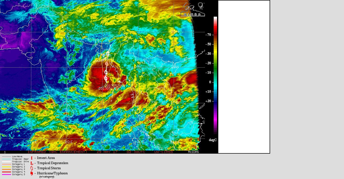
UW-CIMSS IR (NHC Enhancement) Satellite Image & Forecast Track of Cyclonic Storm 02B.MORA
29th May 2017 @ 0230 UTC ( 08.00 am. IST)
1 knot= 1.85 km./hour
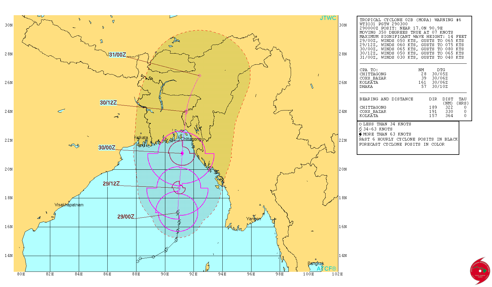
From JTWC:
JTWC Tropical Cyclone 02B (MORA) Warning No. 6 On 29th May 2017 @ 0300 UTC ( 08.30 am. IST)
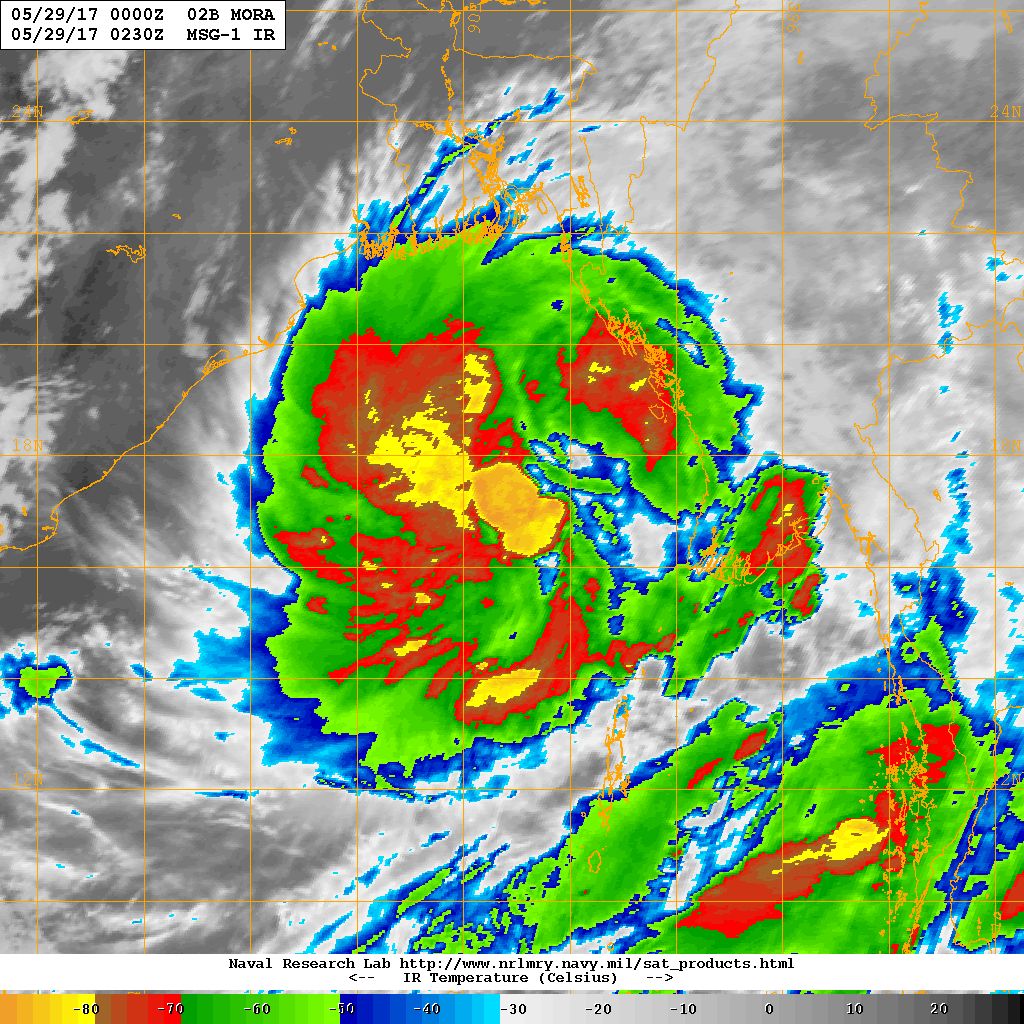
NRL IR Satellite Image of Cyclonic Storm 02B.MORA on 29th May 2017 @ 0230 UTC (08.00 am. IST)
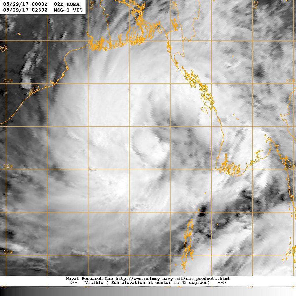
NRL Visible Satellite Image of Cyclonic Storm 02B.MORA
on 29th May 2017 @ 0230 UTC (08.00 am. IST)
Caution: Please refer/rely on IMD/RSMC Bulletins/Advisories for Storms & Weather related matter.
સાવચેતી:
સ્ટોર્મ કે હવામાન અંગે ની માહિતી માટે ભારતીય હવામાન ખાતા/ગવર્મેન્ટ ના બુલેટીન/સુચના પર નિર્ભર રહેવું.