Current Weather Conditions on 29th May 2017 @ 9.30 am. IST
Sub: Cyclonic Storm ‘MORA’ over Eastcentral Bay of Bengal
The Cyclonic Storm ‘MORA’ over Eastcentral Bay of Bengal moved North-Northeastward during past 06 hours with a speed of 13 kmph and lay centered at 0530 hrs IST of today, 29 th May, 2017 over Eastcentral Bay of Bengal near Latitude 17.0ºN and Longitude 91.3ºE, about 680 km South-Southeast of Kolkata and 580 km South-Southwest of Chittagong. The System is likely to intensify further into a Severe Cyclonic Storm during next 12 hours. It is very likely to move North-Northeastwards and cross Bangladesh coast between longitude 91.0ºE and 92.0ºE near Chittagong around 30th May 2017 forenoon.
INDIA METEOROLOGICAL DEPARTMENT
Bulletin No.: 09 (BOB 02/2017)
Time of issue: 0800 hours IST
Dated: 29.05.2017 available here IMD Bulletin No.: Nine
Yesterday’s Deep Depression over Eastcentral bay of Bengal strengthened further to a Cyclonic Storm ‘MORA’ over that region late around 11.30 pm. IST yesterday. This System is expected to strengthen further to a Severe Cyclonic Storm within 24 hours. International Agencies have this System at 50 knots wind speed ( based on 1 minute average wind speed ) & 988 mb pressure location Lat. 17.0N & Long 90.9E.
Note: IMD considers wind speed based on 3 minute Average in their System classifications.
મધ્ય બંગાળ ની ખાડી ની સિસ્ટમ ‘મોરા’ નામ ના વાવાઝોડા માં પરિવર્તિત થઇ છે. 24 કલાક માં સિસ્ટમ હજુ મજબૂત બની તિવ્ર વાવાઝોડા માં પરિવર્તિત થશે. ઇન્ટરનૅશનલ એજન્સી મુજબ 50 નૉટ પવન ની ઝડપ છે ( જે એક મિનિટ ની શરેરાશ પવન મુજબ ગણે છે ,જયારે હવામાન ખાતા મુજબ પવન ની ઝડપ 3 મિનિટ ની શરેરાશ મુજબ ગણતરી થાય.) આ વાવાઝોડું આવતી કાલે બંગલા દેશ પહોંચશે.
| UW-CIMSS Automated Satellite-Based
Advanced Dvorak Technique (ADT) |
|
| Current Intensity Analysis | |
           UW - CIMSS
     ADVANCED DVORAK TECHNIQUE
           ADT-Version 8.2.1
   Tropical Cyclone Intensity Algorithm

    ----- Current Analysis -----
  Date : 29 MAY 2017    Time : 031000 UTC
  Lat :  17:25:19 N     Lon : 90:54:02 E


          CI# /Pressure/ Vmax
         3.4 / 990.5mb/ 53.0kt


             Final T#  Adj T#  Raw T#
               3.4     3.1     3.1

Center Temp: -81.7C Cloud Region Temp: -68.7C

Scene Type : UNIFORM CDO CLOUD REGION

Positioning Method : FORECAST INTERPOLATION

Ocean Basin : INDIAN
Dvorak CI > MSLP Conversion Used : CKZ Method

Tno/CI Rules : Constraint Limits : NO LIMIT
       Weakening Flag : OFF
      Rapid Dissipation Flag : OFF

 C/K/Z MSLP Estimate Inputs :
  - Average 34 knot radii : N/A
  - Environmental MSLP    : 1008mb

 Satellite Name :   HIM-8
Satellite Viewing Angle:59.7 degrees

*********************************
|
UW-CIMSS IR (NHC Enhancement) Satellite Image & Forecast Track of Cyclonic Storm 02B.MORA
29th May 2017 @ 0230 UTC ( 08.00 am. IST)
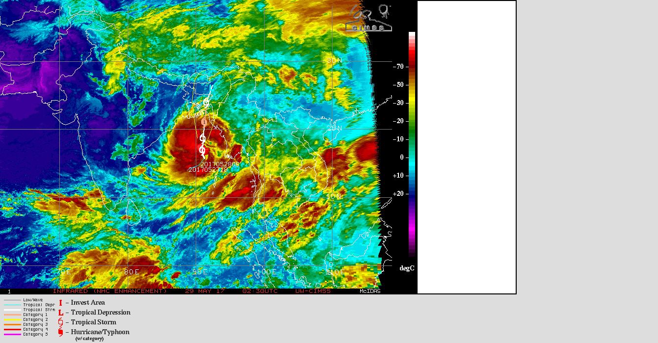
1 knot= 1.85 km./hour
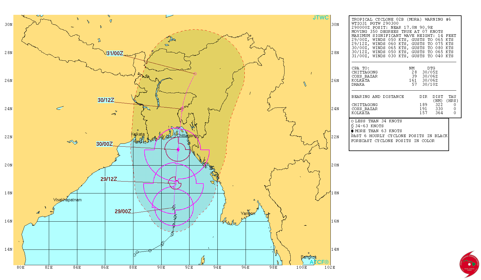
From JTWC:
JTWC Tropical Cyclone 02B (MORA) Warning No. 6 On 29th May 2017 @ 0300 UTC ( 08.30 am. IST)
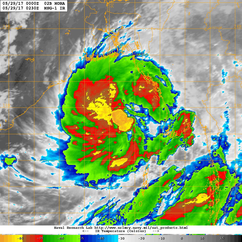
NRL IR Satellite Image of Cyclonic Storm 02B.MORA on 29th May 2017 @ 0230 UTC (08.00 am. IST)
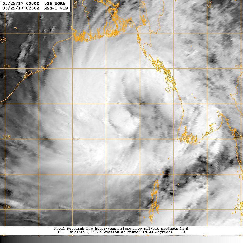
NRL Visible Satellite Image of Cyclonic Storm 02B.MORA
on 29th May 2017 @ 0230 UTC (08.00 am. IST)
Caution: Please refer/rely on IMD/RSMC Bulletins/Advisories for Storms & Weather related matter.
સાવચેતી:
સ્ટોર્મ કે હવામાન અંગે ની માહિતી માટે ભારતીય હવામાન ખાતા/ગવર્મેન્ટ ના બુલેટીન/સુચના પર નિર્ભર રહેવું.
banaskath ma,,panaavisake
plizz,,,,05/08/2017..nu,,,aavvanu,,chhe..tevu,,paperma,,aavel
Tamo kai post vancho chho ?
Je lakho te je post hoy te ange lakho.
Sir as varse Gujarat ma ketla% jetlo varshad padvani Sakyta se
Chheli post vancho !!!
Sir we observed that after any cyclone it effect the monsoon…and at the end of cyclone ocean became silent and quiet for long time and delayed the rain.. wat would you like to say on this query
It depends upon the direction of Cyclone. Winds have become conducive for Monsoon onset over Northeast states and South Arabian Sea and now Kerala
Namste sir 48-63;knot ni zadap hoy to tyare j eane tivra vavazodu kevay? Kadach kevay to internation agency te zadap ketli rakhe?
Haal International vara 55 knot chhe. 1 kalak ma navu avashe.
Sir mora’ vavazoda na karane gujarat na chomasane kai asar thay ?
Kale vavazodu Bangla Desh ponchi jashe.
Pachhi navi ghodi navo daa !!
sir kutchh pakistan border par UAC se?
Saurashtra, Kutch ane lagu Arabian Aaspaas 850 hPa ma 31 tarikh batave chhe UAC
Sir chomasu rekha aaje ghani aagad vadhel 6..arabian sea sudhi pahonchel 6..to have next kerala hoi sake ne?
Yes
Cyclonic strom ‘mora’ effect monsoon progress 2017 india ?
Shu kaheva maago chho ?
Ahi Gujarati ma chhoot chhe !
Sar.
Bob Negetiv chhe and iod positive chhe
To varsad ochho pade? To chhu bob ma system ochhi bane ? To Gujarat ma tenathi varsad ma kai fer pade?
IOD dar athavadiye update thato hoi.
Koi fix na hoi
Sir
iod ghate te fayad karak hoy se ke vadhe te?????
Positive faydakarak rahe
Sri Gujrat MA andajit kyare vavni thashe?
Saro varsad padey tyare vavani thaay.
Sir
Aje paper avse update ma?
Yes
menu ma ny pan aa update ma current intensity analysis vadu yellow column che eno adhdho jamni baju no bhag mobile ma ny dekhato sir.
Thodu repair karel chhe.
Next time format saru thaay evu karshu.
Sir lod su 6
Indian Ocean Dipole.
Vigat maate ahi Menu ma IOD ni link chhe.
Thank you sir, for new update. Sir hve to adat padi gai ke dar 2 kalake gujarat weather app jovi pade. Niswarth bhave seva apva badal apne koti koti vandan
Sir aa vavajodu amdavad ne pan asar karse
Vavazodu Bangla Desh baju jaay chhe.
Unalu pak ne nuksankark suorastra ma varsad thay sake?
Zaapta hadvo kyan kyan thai shake. Premonsoon.
Sir arbin see uper uac thay se te vavni karak varsad thay sake ke nay
Zaapta hadvo thai shake
Sir atyre varshad thay to vavni kehvay ke nay
Vavani toe ketlo varsad thaay te oopar hoi.
Chomasu besvu ane varsad thavo be alag chhe.
1.)Sir have bhej nu praman pan vadi rahyu chhe to Have Local System Bani sake ? 2.) local system Satellite map maa jovay kharu ? 3.) Local System banva maatenaa paribalo kaya kaya hoy ? 4.)Local System Banva maate Pavan ni Speed ketli joy ? 5.) Aa pavano 21 km thi 25 km naa haal maa chhe to su Gujarat maa Thunderstorm Thaay kharu ? 6.) Thunderstorm thaay to aeni disha kaya to ke kay baaju gati kari sake ? Please sir Answer aapjo kem ke aa varse bob Negative chhe to Bob maaathi ghani occhi system Gujarat taraf aavse… Read more »
Motu lesson chhe.
Badha jawab nahi apu.
Haal Premonsoon kaho local system kaho te thashe.
pavan vadhu raheshe.
Coastal area temaj Gujarat baju pan Zaapta/varsad thai shake.
Haal BOB ma System chhe.
IOD thodu ghati gayu chhe. +0.19 chhe chhelu.
Sir premonsoon aaj thi shalu thashe saurstrma
Evu fix na hoi pan aajthi vatavaran thayu chhe evu.
sir mobile ma upar yellow colour ni information horizontal view no adhdho bhag j dekhai che ane bijo bhag ny dekhato to jo repair thai to krjo ne.
Bahu samjanu nahi.
Menu ma kai jagye te lakho toe khyaal avey.
Sir mora cyclone ni effect Gujarat Na chomasa Na agamana ma avase ke nay. Chomasa nu agaman late jase ke ej time avase.
Premonsoon thaay
Pavan raheshe
700hpa ma date 31-1 na saurashtra cost Pase uac btave 6
Where i can see anti cyclon
Weather Chart ma jovanu.
Sir anticyclone in arabian sea is still persist or not
NO
Thanks sir new update
Sir vavajodani asar gujratma thashe?
No
Pavan raheshe ane premonsoon chalu
Sir Gujarat ne Kai asar Thai
No
Pavan raheshe premonsoon chalu thaay
lage se kerala pela west bangal ma monsoon pela antry marse.