Current Weather Conditions On 6th June 2013 @ 2.00 pm.
From IMD Inference:
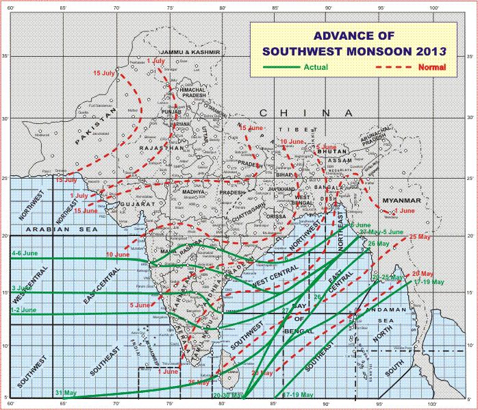
The Southwest Monsoon has further advanced into some more parts of Madhya
Maharashtra; some parts of Marathwada; remaining parts of north interior Karnataka;
most parts of Telangana, coastal Andhra Pradesh and central Bay of Bengal; some parts
of northwest and some more parts of northeast Bay of Bengal.
The Northern Limit of Monsoon (NLM) passes through Lat. 18° N / Long. 60° E,
Lat. 18° N / Long. 70° E, Harnai, Parbhani, Ramagundam, Vishakhapatnam, Lat. 18° N /
Long. 87°E and Lat. 21° N / Long. 92°E.
Conditions are favourable for further advance of southwest Monsoon into some more
parts of Bay of Bengal; some parts of northeastern States, Sikkim and some parts of Sub-
Himalayan West Bengal & Sikkim during next 2 – 3 days.
The southwest Monsoon has been vigorous over north interior Karnataka.
IMD Map of Advance of Southwest Monsoon 2013 on 6th June 2013
Forecast: 6th June to 10th June
Saurashtra, Gujarat & Kutch:
Conditions are improving before onset of Southwest Monsoon over Saurashtra, Kutch & Gujarat. The Barometric Pressure was between 1000 Mb. to 1004 Mb. during the 24 hour periods during the last few days. Looking 7 days ahead the Forecast Barometric Pressure is expected to be in the range of 994 Mb. to 998 Mb. and the Humidity has also increased considerably which indicates the Monsoon is round the corner. The Pre-Monsoon activity will increase both in the areas covered and quantum of rain during the forecast period.
Weather Forecast In Akila Daily Dated 6th June 2013 @ 10.30 am.
Scroll Up