Saurashtra & Kutch Rainfall Prospects Expected to Improve During 12th–16th September 2026 — Forecast for 9th–16th September 2026
સૌરાષ્ટ્ર અને કચ્છમાં 12થી 16 સપ્ટેમ્બર 2026 દરમિયાન વરસાદના સંજોગોમાં સુધારો થવાની શક્યતા — 9થી 16 સપ્ટેમ્બર 2026 માટેની આગાહી
Few parameters from IMD Bulletin — 9th September 2026:
- The western end of the Monsoon Trough is north of its normal position, while the eastern end is near its normal position at mean sea level.
- An upper-air cyclonic circulation lies over north Bay of Bengal & adjoining Bangladesh coast in the lower and middle tropospheric levels. Under its influence, a Low Pressure Area is likely to form over the North Bay of Bengal & neighbourhood around 10th September 2026.
- A trough runs from Rayalaseema to the Gulf of Mannar in the lower tropospheric levels.
- An upper-air cyclonic circulation lies over Saurashtra & neighbourhood in the lower tropospheric levels.
- An upper-air cyclonic circulation lies over north Haryana & neighbourhood in the lower tropospheric levels.
- The Western Disturbance as a cyclonic circulation lies over northwest Uttar Pradesh & neighborhood in the middle tropospheric levels.
Weather Forecast for Saurashtra, Gujarat & Kutch (9th–16th September 2026)
Overall: Rainfall prospects are expected to improve during the forecast period due to the upcoming Low Pressure Area and associated Upper Air Circulation (UAC) at various levels, tilting southwestward with height over Madhya Pradesh and adjoining Maharashtra areas.
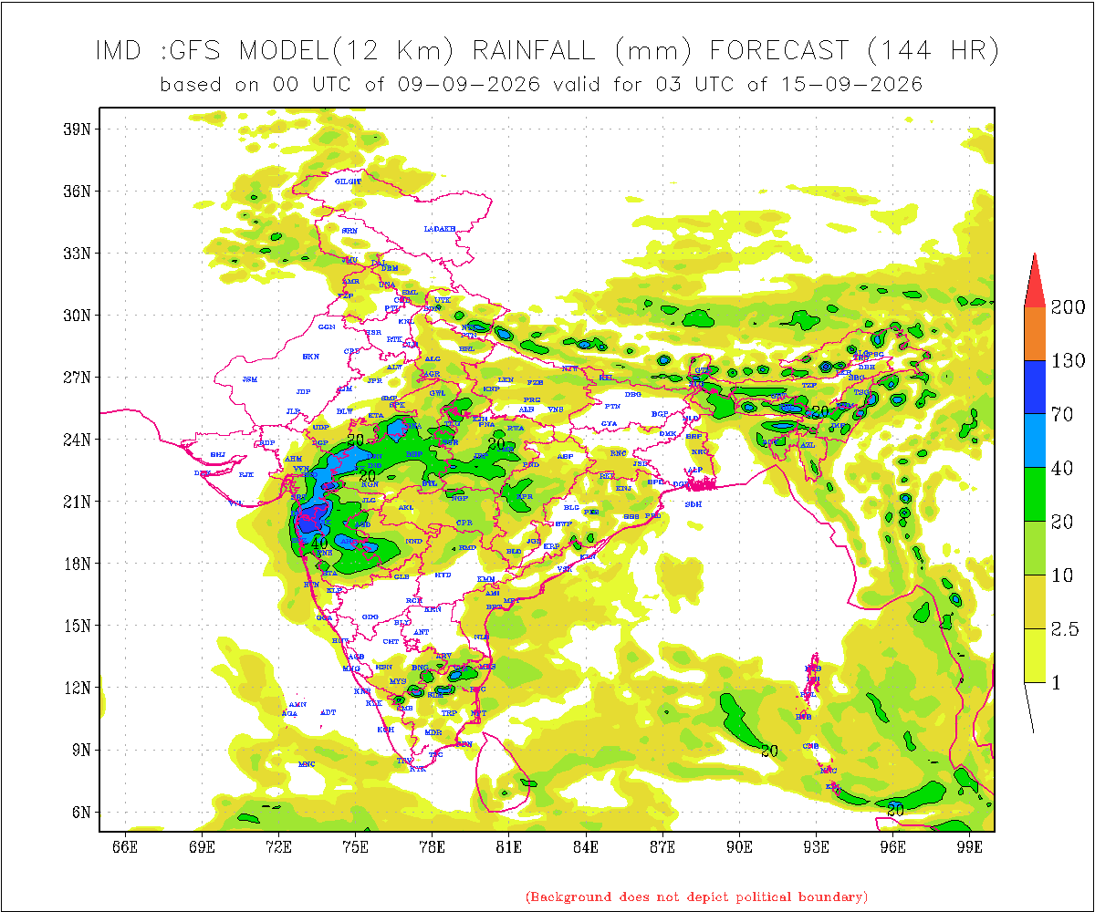
There is a differing outcome in the IMD GFS output from the 09-09-2026 00 UTC run, as well as in the NOMADS GFS for the same run time. These models indicate considerably lower rainfall over Gujarat State compared to various other forecast models, including ECMWF, ICON and other international models.
The rainfall forecast given here is therefore higher than the current IMD GFS model outcome, based on various model guidance regarding the potential Low Pressure Area and its track along with Monsoon trough moving southwards towards normal.
Gujarat Region
- Rainfall: Scattered rainfall is likely over parts of Gujarat Region on different days, mainly during 12th–16th September.
- 50% of the area is expected to receive 20–35 mm of total rainfall during the forecast period.
- The remaining 50% of the area is expected to receive 35–75 mm of total rainfall during the forecast period.
- Isolated locations could receive more than 100 mm of total rainfall.
Saurashtra & Kutch
- Rainfall prospects over Saurashtra & Kutch are expected to improve during 12th–16th September 2026.
- Rainfall: Scattered rainfall is likely on different days of the forecast period, mainly during 12th–16th September.
- 50% of the area is expected to receive 25–50 mm of total rainfall during the forecast period.
- The remaining 50% of the area is expected to receive up to 25 mm of total rainfall during the forecast period.
- Isolated locations could receive more than 100 mm of total rainfall.
Note: When the Low Pressure Area develops over the Bay of Bengal and its initial location becomes established, the above forecast will be revisited if required.
Introducing: KOLA Interactive Rainfall Forecast Atlas
All India States and within each State up to District level Rainfall data is available. Select your State and subsequently all Districts will also be listed within your State in Alphabetical order. This data is based on IMD GFS Daily Precipitation Forecast for 1 to 10 days.
સૌરાષ્ટ્ર અને કચ્છમાં 12થી 16 સપ્ટેમ્બર 2026 દરમિયાન વરસાદના સંજોગોમાં સુધારો થવાની શક્યતા — 9થી 16 સપ્ટેમ્બર 2026 માટેની આગાહી
IMD બુલેટિન — 9 સપ્ટેમ્બર 2026ના કેટલાક મહત્વપૂર્ણ પરિબળો:
- મોન્સૂન ટ્રફનો પશ્ચિમ છેડો તેની સામાન્ય સ્થિતિથી ઉત્તર તરફ છે, જ્યારે તેનો પૂર્વ છેડો સમુદ્ર સપાટી પર તેની સામાન્ય સ્થિતિની નજીક છે.
- નીચલા અને મધ્ય ટ્રોપોસ્ફેરિક સ્તરે ઉત્તર બંગાળની ખાડી અને તેને અડીને આવેલા બાંગ્લાદેશના દરિયાકાંઠા વિસ્તારમાં ઉપરના વાતાવરણમાં ચક્રવાતી પરિભ્રમણ યથાવત્ છે. તેના પ્રભાવ હેઠળ 10 સપ્ટેમ્બર 2026ની આસપાસ ઉત્તર બંગાળની ખાડી અને આસપાસના વિસ્તારમાં લો પ્રેશર એરિયા રચાવાની શક્યતા છે.
- નીચલા ટ્રોપોસ્ફેરિક સ્તરે રાયલસીમાથી ગલ્ફ ઑફ મન્નાર સુધી ટ્રફ વિસ્તરેલો છે.
- નીચલા ટ્રોપોસ્ફેરિક સ્તરે સૌરાષ્ટ્ર અને આસપાસના વિસ્તારમાં ઉપરના વાતાવરણમાં ચક્રવાતી પરિભ્રમણ યથાવત્ છે.
- નીચલા ટ્રોપોસ્ફેરિક સ્તરે ઉત્તર હરિયાણા અને આસપાસના વિસ્તારમાં ઉપરના વાતાવરણમાં ચક્રવાતી પરિભ્રમણ યથાવત્ છે.
- મધ્ય ટ્રોપોસ્ફેરિક સ્તરે વેસ્ટર્ન ડિસ્ટર્બન્સ તરીકેનું ચક્રવાતી પરિભ્રમણ ઉત્તર-પશ્ચિમ ઉત્તર પ્રદેશ અને આસપાસના વિસ્તારમાં યથાવત્ છે.
સૌરાષ્ટ્ર, ગુજરાત અને કચ્છ માટે હવામાન આગાહી (9થી 16 સપ્ટેમ્બર 2026)
એકંદરે: આગાહી સમયગાળા દરમિયાન વરસાદની સંભાવનાઓમાં સુધારો થવાની શક્યતા છે. તેનું મુખ્ય કારણ આગામી લો પ્રેશર એરિયા અને વિવિધ સ્તરે તેની સાથે સંકળાયેલું અપર એર સાયક્લોનિક સર્ક્યુલેશન (UAC) છે, મધ્ય પ્રદેશ અને તેને અડીને આવેલા મહારાષ્ટ્રના વિસ્તારો પર, જે વધતી ઉંચાઈએ દક્ષિણ પશ્ચિમ તરફ ઝુકે.
09-09-2026 00 UTCના IMD GFS આઉટપુટ તેમજ સમાન રન સમયના NOMADS GFSમાં વરસાદના પરિણામમાં તફાવત જોવા મળે છે. આ મોડેલો અન્ય વિવિધ આગાહી મોડેલો, જેમાં ECMWF, ICON અને અન્ય આંતરરાષ્ટ્રીય મોડેલોનો સમાવેશ થાય છે, તેની સરખામણીએ GFS ગુજરાત રાજ્યમાં નોંધપાત્ર રીતે ઓછો વરસાદ દર્શાવે છે.
આથી અહીં આપવામાં આવેલી વરસાદની આગાહી હાલના IMD GFS મોડેલના પરિણામ કરતાં વધુ છે. આ આગાહી સંભવિત લો પ્રેશર એરિયા અને તેની ટ્રેક અંગેના વિવિધ મોડેલ માર્ગદર્શન, તેમજ મોન્સૂન ટ્રફના દક્ષિણ તરફ ખસીને તેની સામાન્ય સ્થિતિ તરફ જવાના વલણને ધ્યાનમાં રાખીને કરવામાં આવી છે.
ગુજરાત રિજન
- વરસાદ: ગુજરાત રિજનના કેટલાક વિસ્તારોમાં અલગ-અલગ દિવસોમાં છૂટાછવાયા વરસાદની શક્યતા છે, ખાસ કરીને 12થી 16 સપ્ટેમ્બર દરમિયાન.
- આગાહી સમયગાળા દરમિયાન 50% વિસ્તારમાં કુલ 20–35 મિમી વરસાદ થવાની શક્યતા છે.
- બાકીના 50% વિસ્તારમાં કુલ 35–75 મિમી વરસાદ થવાની શક્યતા છે.
- આઇસોલેટેડ સ્થળોએ કુલ વરસાદ 100 મિમીથી વધુ થઈ શકે છે.
સૌરાષ્ટ્ર અને કચ્છ
- 12થી 16 સપ્ટેમ્બર 2026 દરમિયાન સૌરાષ્ટ્ર અને કચ્છમાં વરસાદની સંભાવનાઓમાં સુધારો થવાની શક્યતા છે.
- વરસાદ: આગાહી સમયગાળા દરમિયાન અલગ-અલગ દિવસોમાં છૂટાછવાયા વરસાદની શક્યતા છે, ખાસ કરીને 12થી 16 સપ્ટેમ્બર દરમિયાન.
- આગાહી સમયગાળા દરમિયાન 50% વિસ્તારમાં કુલ 25–50 મિમી વરસાદ થવાની શક્યતા છે.
- બાકીના 50% વિસ્તારમાં કુલ 25 મિમી સુધી વરસાદ થવાની શક્યતા છે.
- આઇસોલેટેડ સ્થળોએ કુલ વરસાદ 100 મિમીથી વધુ થઈ શકે છે.
નોંધ: બંગાળની ખાડી પર લો પ્રેશર એરિયા રચાય અને તેનું પ્રારંભિક સ્થાન સ્પષ્ટ થાય ત્યારબાદ, જરૂર જણાય તો ઉપરોક્ત આગાહીની પુનઃસમીક્ષા કરવામાં આવશે.
પરિચય: KOLA Interactive Rainfall Forecast Atlas
ભારતના તમામ રાજ્યો તેમજ દરેક રાજ્યના જિલ્લા સ્તર સુધીના વરસાદના અનુમાન ઉપલબ્ધ છે. તમારું રાજ્ય સિલેક્ટ કરો અને પછી દરેક ડીસ્ટ્રીકટ ના આંકડા ઉપલબદ્ધ થશે અલ્ફાબેટિક ક્રમ માં. આ માહિતી IMD GFS મોડેલના 1 થી 10 દિવસના દૈનિક વરસાદ (Daily Precipitation)ના ફોરકાસ્ટ અનુમાન પર આધારિત છે.
Caution: Please refer/rely on IMD/RSMC Bulletins/Advisories for Storms & Weather related matter.
સાવચેતી: સ્ટોર્મ કે હવામાન અંગે ની માહિતી માટે ભારતીય હવામાન ખાતા/ગવર્મેન્ટ ના બુલેટીન/સુચના પર નિર્ભર રહેવું.
Read Comment Policy – કમેન્ટ માટે માર્ગદર્શન વાંચો
How To Upload Profile Picture For WordPress – વર્ડપ્રેસ માં પ્રોફાઈલ પિક્ચર કેમ રાખવું
Forecast In Akila Daily Dated 9th September 2026
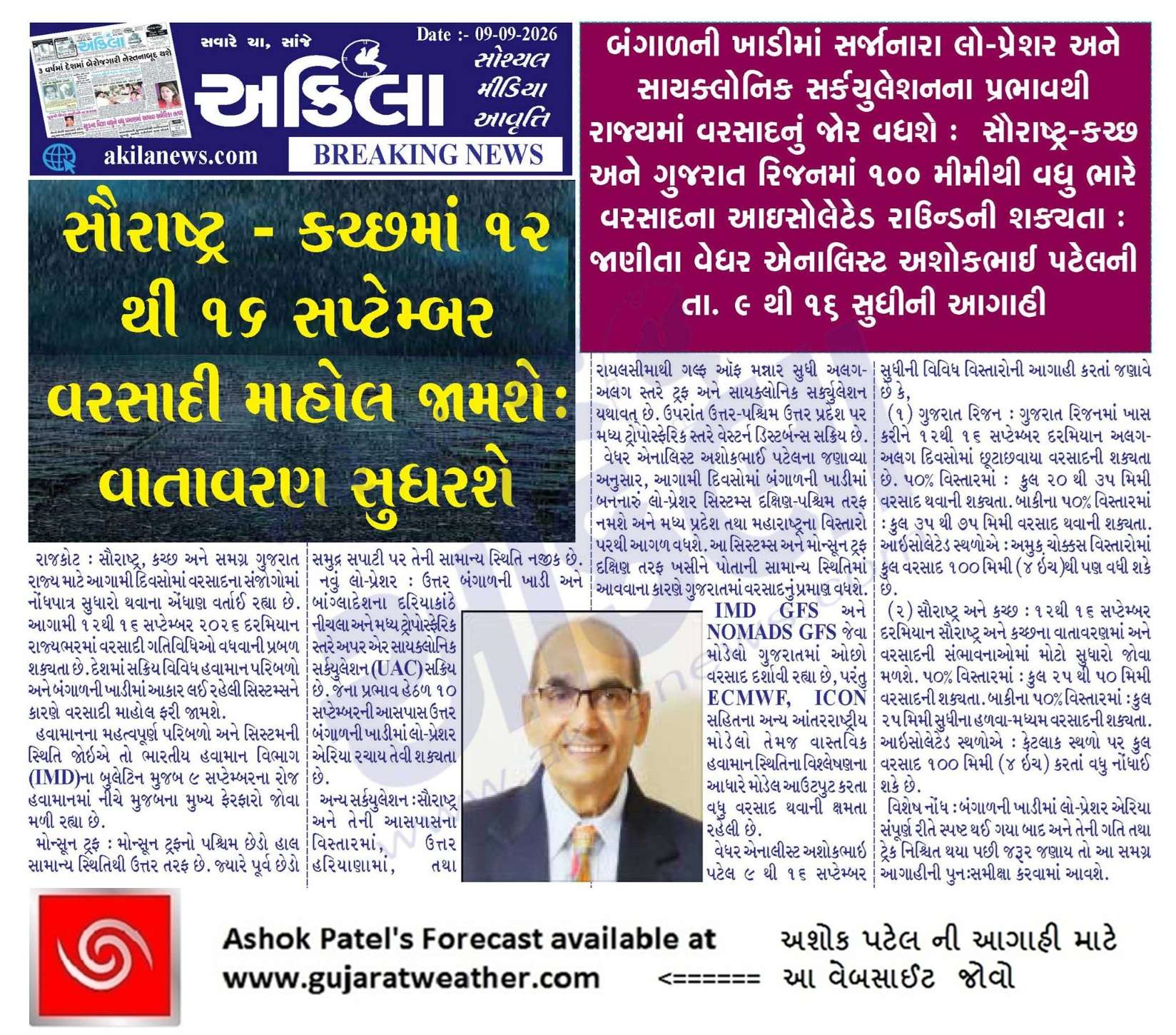
Pending Forecast In Sanj Samachar Daily Dated 9th September 2026
KOLA Interactive Rainfall Forecast Atlas
Imd GFS 23 July ae 2-10mm varsad batavtu hatu Dholka mate
per padyu 473mm ECMWF ane ICON pramane
Imd gfs ae low pressure Bhi predict natu karyu ae vakhte…
aakhi season ma fail gyo che imd model etle tension na kro varsad avse saurashtra ma Bhi…
કોય પણ વિસ્તાર મા વરસાદ ચાલુ થાય એટલે સમાચાર આપજો
Good Afternoon Sir. Could this be the first proper rain spell of the season for Rajkot and many other parts of Saurashtra Kutch region ? Also, can we expect another weather update from you today?
Updated today
Sir imd gfs ma pan dark colour aavi gayo to have matra ma dharkham vadhara ni update aapi do atle aanando
સર થોડા ગણો વરસાદ આવશે એ તો પાકું છે પણ નવા તર પાણી થશે એ બાબતે તમે કંઈક ચોખવટ કરો
Update aapel chhe
Ashok sir.imd GFS bov bivdave che saurashtra ne.
Sir. aa round ma Pavan kevo raheshe……
Bey/Tran divas raheshe
Imd gfs navi update ma pani ma besi gayu Saurashtra mate
bhai imd sachu padse mara mate
આવનારી સિસ્ટમ બાબતે ECMWF model કરતા icon model ચોમાસુધરી નોર્મલ અથવા નીચે આવશે અને ગુજરાત તરફ આવશે તેમ માહિતગાર કર્યા હતા…icon model ધીરે ધીરે idle થાય છે…બાકી આશા છોડી દીધી હતી.
To have puru
Aajni IMD gfs latest update kutch, north gujarat ma vadhu varsad batave chhe. Paschim saurashtra mate ocho varsad batave chhe.
Imd gfs lain upar aaviyu
મિત્રો હવે તો આપણા ગુજરાત ના મંત્રી ઋષિકેશ પટેલ પણ કહેવા માંડ્યા કે તા. ૧૨ થી ૧૬ માં વરસાદ આવશે.ખેડુત ભાઈ ચિંતા ન કરો…રામ ભરોસે રહો ને મોજ કરો.. આને કોક સમજાવો કે પક્ષિમ સૌરાષ્ટ્ર માં કદાચ ૫૦ ઈચ વરસાદ પડે તો પણ ખરીફ પાક ને કોઈ ફાયદો નથી થાવાનો.તમારી લીલા બંધ કરી ને આ વિસ્તાર ને અસરગ્રસ્ત જાહેર કરો…
Update based on 0530 hrs IST of today, the 12th September 2026
The Low Pressure Area lay over Coastal areas of south Odisha – north Andhra Pradesh lay over South Chattisgarh & neighbourhood at 0530 hrs IST of today, the 12th September 2026. It is likely to move west-northwestwards across south Chhattisgarh & Vidarbha during next 24 hours. IMD
Light drizzle started in Vadodara
સર તમારો અને રામજીભાઈ કચ્છી અન્નદાતા વેધરનો સાર્વત્રિક રાઉન્ડ કોને કહેવાય તો તેમના અભિપ્રાય આ મુજબ હતા તેવો હું મારા વિડિયો માં ઉલ્લેખ કરું છું
Havaman khata mujab lakvanu ke bolvanu.
Arth na anarth thaay ..Hu shu kahu chhu tema.
IMD ni defination chhe j ISOL SCTR FWS and WS
ઓકે સર
એવુ ન કરતા વાયરલ વાળા વાટ જોઈ ને જ બેઠા હોય. એ પાછા મરીમસાલા વધુ ઉમેરી ને ખોટી માહિતી ફેલાવશે.
Sir ISRO ek notification ma kahe se ke October thi December sudhi ma 3 cyclone banse
સર હવે થોડુંક મોજ માં આવ્યું IMD GSF 18 UTC
Waah
Sir 24 25 date ma bangal ni khadi ni sistum batave se te gujarat ne labh Aape?
Aa Paheli Jaan ne toe aavavaa diyo Dham Dhum thi!
Bija Low Pressure nu haju Magu naaiykhu chhe…. ‘JAL’ nathi aapyu !
Good
બરોબર છે એકનુ તોકરો
Sir તમારી કોમેન્ટ મા ક્યારેક ક્યારેક એકલા એકલા હસુ ave છે
Superb rply sir
Pravinbhai, hamna dhyaan apo khali atyar ni system par je 13 thi 15 tarikh ma aavse. Atyare to aava do varsad aa 3 diwas ma. 24th 25th haji vaar che.
Mitro 2026 nu year karata aa badha modalo ane aa system vadhu yad rese word cup ni fainal mech chheli ovar saro bestmen ne saro bolar chhako mare ka dandiya pade avu chhe, bhare rachakachi.
૧૩ તારીખ ૯:૦૦ pm સુધી નું ત્રણેય મોડલ માં લગભગ એક સરખો જ ટ્રેક બતાવે છે વરસાદ ની માત્રા માં થોડો ફેરફાર છે એટલે એવું લાગે છે કે આવતા એક બે દિવસ માં GFS પણ ecmwf અને icon ની જેમ રંગબેરંગી થાય તો નવાઈ નહીં
Sir aa system ma gajvij nu praman vadhu rahe ne karnke ghana lamba time thi gujarat ma varsad padyo nathi Ane atyare bhadarve pn maja muki se tadka ni, Ane asthirta ni
Sir chomasa ma varsad ma vadhu gap pade tyare gajvij vadhi jay evu hoy ne
Ane aam pan avar aakhu chomasu puru thava aavyu eky var gaj vij thayu nathi amari baju baki varsad 32inch padi gayo
Jay mataji sir jaan saurastra sundhi pochvani sakyata khari.. ?
System pahoche ke na Pahonche, Saurashtra/Kutch/Gujarat Region ne UAC vadhu madad karey chhe.
ECMWF forecasting ma Boss hatu,ane raheshe pan khara.karan ke teni last 5 update ma koi moto ferfar nathi.
Jsk, Tamne su lage che ?
અમ ને. સારૂ લાગે
To amari na j nathi labh pacham sudhi !!!!!!
Aavshe j …jordar…finally
Matra je models ma batave aene j final na ganvi..
no boss only kudrat is boss doat be positive sahheb pan eej k chey
Ecmwf One man show
European model aakha world ma top par aave che..clear winner che compare to GFS & others
સાહેબ તમારી અપડેટ માં વરસાદની માત્રામાં કાંઈ ફેરફાર કરવો પડશે અને તે અપડેટ ની રાહ જોઈને બેઠા છીએ માત્રામાં વધારો થઈ જાય અને તમારી મોર લાગી જાય તેની આતુરતાથી રાહ જોઈએ છીએ
IMD divas ma char vaar update karey chhe.
Aagahi samy 12-16 chhe.
Haju time chhe.
Ok sir
જેમ કોઈ સિસ્ટમ પસાર થાય ત્યારે પૂછડિયા વાદળો પણ વરસાદ આપતા હોય છે તો શું એવું બની શકે સિસ્ટમ પસાર થાય તે પહેલા ના અગાઉના વાદળો વરસાદ આપી શકે?
System pahela na Vadad j pahela Nagaara Vagadata hoy chhe !
Atle sir ji nu kevu em thy he ke gaj vij varo varsad 12 date thi chalu thy che
Sir Nagara Ni Sathe Sathe Fatakada Fodata Hoy Te Vadhu Saru Bandh Besatu Raheshe…Ke Nahi Sir?
ghani var banyu che system vay gaay pasi varsad padel che
સર હવે તો બધું જ તમારી રેન્જ માં આવી ગયું હવે તો કહો કે પશ્ચિમ સૌરાષ્ટ માં આ રાઉન્ડ કેવો રહેશે
Update aapi te maari range maa j hati. Chhata Update ni jarur padey toe aapish tenu kaaran em chhe ke IMD GFS vadhu padtu judu rahyu bija badha model thi. Havey thodi sharam chhuti chhe. Aasha raakhu chhu ke ‘Ghumato’ kaadhi nakhey (Aavati kaal ni IMD GFS precipitation update sudhi ma)
Sir Tamara javab lajwab hoy che
Pan sir imd a to 1 agust vari system ma sauratra ni school ma 3 divas ni raja જાહેર kari hati bhare varsad avse
Pan kay no aviyu a ખોટા chhe
Ek Baju IMD Khota chhe toe Gam Aa aakhu varsash Tachli Dadiye betha hata enu shu ?
System avse tya sudhi ma Model anek vaar badlse model upr bharoso 70 thi 80% rakhvo pde ane jamin upr pde e j sachu gnvanu
Ane ger marge dorta Tv news ni Aghaio upr to lokoe 1% Bharoso nai rakhvano e to 3 System sathe pur pan lai avse.
New varsad round west saurashtra mate khub mahtvno rese Ashok sir nu soda lemon best j rese next navi update ma.
જી એસ એફ પણ જમણવાર ની પંગતમાં બેસી ગયું.
Pan tene Ketliye Vangi ni ‘agad’ chhe !
GFS મોડલ પંગત માં બેસી ગયું છે તેમ કહો છો પણ તેને ઘણી વાનગીઓ ની અગળ છે
?????
અગળ એટલે આખડી …કોઈ ને ગોળ ની આખડી હોય કોઈ ને ઘી ની ..એમ આ જીએફએસ ને વધુ વરસાદ ની આખડી છે સાહેબ નુ કહેવુ એમ થાય છે
Tema fer far thashe. (Jokey badha model ma thoda fer far thata hoy chhe jem time najikm aavey tem final thatu jaay)
અગળ wah sudh desi sabad
Atyarni ecmwf ni update ma rajkot ma sunday rat thi monday rat sudhi ma 25 inch varsad batave chhe !!!
2013 vari kare to
Tarikh 12 thi 17 ma Saurastra kachh ma saravtrik varasad 25mm thi 100mm amuk vistar ma 150mm k tethi vadhu thai tevi sakyata.
તારીખ: 11 સપ્ટેમ્બર 2026 આજની પરિસ્થિતિ ભારતીય હવામાન વિભાગ અનુસાર મીડ ડે બુલેટિન લો પ્રેશર: ઉત્તરપશ્ચિમ–મધ્યપશ્ચિમ બંગાળની ખાડી તથા દક્ષિણ ઓડિશા–ઉત્તર આંધ્રપ્રદેશના દરિયાકાંઠા નજીક રહેલું લો પ્રેશર આજે, 11 સપ્ટેમ્બર 2026ના રોજ સવારે 8:30 વાગ્યે પણ યથાવત્ છે. તેની સાથે જોડાયેલું ચક્રવાતી પરિભ્રમણ સમુદ્ર સપાટીથી 7.6 કિમીની ઊંચાઈ સુધી વિસ્તરેલું છે અને ઊંચાઈ સાથે દક્ષિણપશ્ચિમ તરફ ઝૂકેલું છે. આગામી 24 કલાક દરમિયાન તે વધુ મજબૂત બનવાની અને ઉત્તર કોષ્ટલ આંધ્રપ્રદેશ–દક્ષિણ ઓડિશા પરથી પશ્ચિમ-ઉત્તરપશ્ચિમ દિશામાં આગળ વધવાની શક્યતા છે. ટ્રફ: ઉત્તર રાજસ્થાનથી મધ્યપ્રદેશ અને છત્તીસગઢ થય ને લો પ્રેશર ના આનુષાંગિક UAC સુધી લંબાઈ છે. આ ટ્રફ હવે સરેરાશ સમુદ્ર સપાટીથી… Read more »
Skymet vada Uttar Gujarat ane daxin gujarat bane ma saro varsad kye che saurashtra Ane Kutch ma ocho varsad kye che
sachi vat che
સાહેબ આં વર્ષ ની સૌથી બેસ્ટ અપડેટ ફરીવાર આજ આપી દો અને એમાં જૂના શબ્દો જેવાકે આંનદો મેઘરાજા મહેરબાન આવું હેડિંગ આપી ને અપડેટ આપી દો ભલે થઈ જાય તમારી જ સાઈન બાકી છે હવે એટલે ફાઇનલ
Atyare 11-09-2026 00UTC KOLA ECMWF ni update ma
(South Gujarat, Rajkot, Jamnagar, Dwarka )
Sir surendranagar vachma che to ame pan
ECMWF 11-09-2026 00UTC
A dvarkadhish ni prashadi hoy sake to.spesyal jamnagar drarka mate
icon gfs bane ak mat thayu છે atyare varsad dhariya karta ocho rese
Model windy ma jovo chho?
Recheck karo.
sar windyma
Windy ma GFS and ICON banney vachey farak chhe. ICON ma vadhu chhe GFS karta
Aa vat khoti chhe bhai tamne jota nathi aavadatu bija ne gote chadavo ma… Jay Shree Radhe Krishna Ji…
દિલીપભાઈ…. આપની આજ સવાર ની કોમેન્ટ થી પણ અમે ગોટે ચડ્યા હતા…..”આજ ની ecmfw માં થોડું નબળું પડ્યું છે” તો શું નબળું પડ્યું છે ?
Koi pan model nu kai tarikh and forecast run time check karo. Model update thayel chhe?
windy na tran model chhe je alag lag time ma update thay chhe.
Aaje imd ni bapor ni update aavse atle sir update aapse matra ma vadhara na right sir ?
IMD already KOLA ahi muki didhel chhe. jovo
Saurashtra no September no avrej varsad janral ketlo hoy.
15-18% Season na