Saurashtra & Kutch Continue To Face Bleak Rainfall Prospects — Forecast For 30th August to 5th September 2026
સૌરાષ્ટ્ર અને કચ્છમાં વરસાદની શક્યતાઓ હજુ પણ ધૂંધળી — 30મી ઓગસ્ટથી 5મી સપ્ટેમ્બર 2026ની હવામાન આગાહી
Few parameters from IMD Morning Bulletin 30th August 2026:
- The Low Pressure Area over northwest Bay of Bengal and adjoining West Bengal–north Odisha coasts lay as a Well-Marked Low Pressure Area over the same region at 0830 IST of today, 30th August 2026.
- The associated cyclonic circulation extends up to 7.6 km above mean sea level.
- The system is likely to move west-northwestwards across north Odisha and Gangetic West Bengal during the next 24 hours.
- The Monsoon Trough at mean sea level now passes through Amritsar, Muzaffarnagar, Hardoi, Gorakhpur, Patna, Bankura, the centre of the Well-Marked Low Pressure Area over northwest Bay of Bengal and adjoining West Bengal–north Odisha coasts, and thence southeastwards to the Eastcentral Bay of Bengal.
- A trough runs from the centre of the Well-Marked Low Pressure Area over northwest Bay of Bengal and adjoining West Bengal–north Odisha coasts to northeast Uttar Pradesh across Jharkhand and Bihar, between 0.9 and 1.5 km above mean sea level.
- An upper-air cyclonic circulation lies over Saurashtra and neighbourhood at 5.8 km above mean sea level.
- The Western Disturbance, as a cyclonic circulation over north Pakistan and adjoining north Punjab, now lies over north Pakistan and adjoining Jammu Division at 5.8 km above mean sea level.
Weather Forecast for Saurashtra, Gujarat & Kutch (30th August up to 5th September 2026)
Gujarat Region:
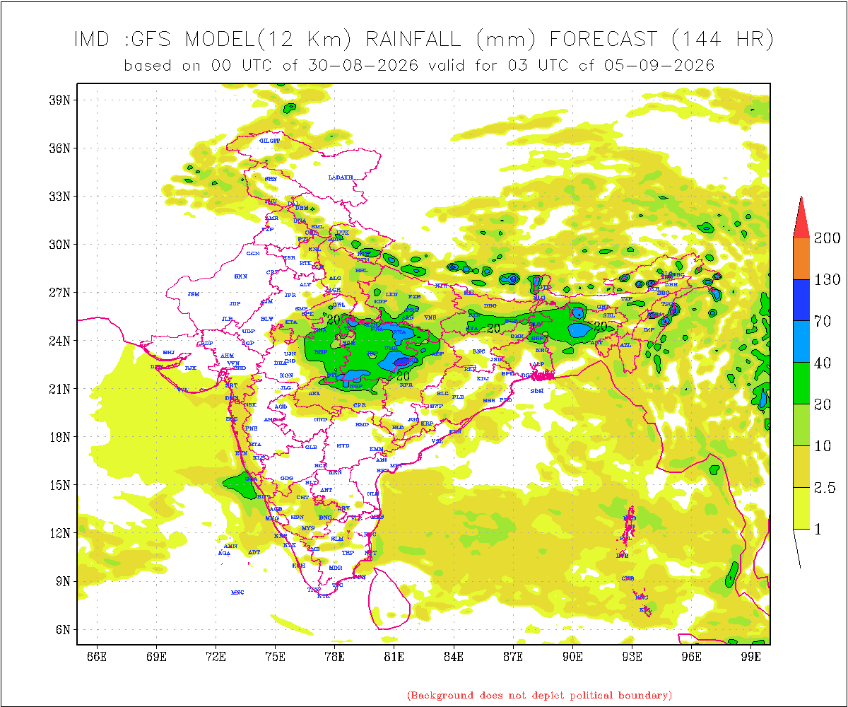
- Rainfall: Mainly Isolated to some Scattered rainfall is likely over areas of Gujarat Region adjoining Madhya Pradesh and Maharashtra during 30th August to 5th September.
Saurashtra & Kutch:
-
- Saurashtra & Kutch Continue To Face Bleak Rainfall Prospects during 30th August up to 5th September 2026.
- Rainfall: Mainly Isolated rainfall is likely on some days during 30th August to 5th September, with no significant rainfall expected.
Introducing: KOLA Interactive Rainfall Forecast Atlas
All India States and within each State up to District level Rainfall data is available. Select your State and subsequently all Districts will also be listed within your State in Alphabetical order. This data is based on IMD GFS Daily Precipitation Forecast for 1 to 10 days.
સૌરાષ્ટ્ર અને કચ્છમાં વરસાદની શક્યતાઓ હજુ પણ ધૂંધળી — 30મી ઓગસ્ટથી 5મી સપ્ટેમ્બર 2026ની હવામાન આગાહી
IMDના 30મી ઓગસ્ટ 2026ના મીડ ડે બુલેટિનમાંથી કેટલીક મહત્વપૂર્ણ બાબતો:
- ઉત્તર-પશ્ચિમ બંગાળની ખાડી અને તેને અડીને આવેલા પશ્ચિમ બંગાળ–ઉત્તર ઓડિશાના દરિયાકાંઠા પરનું Low Pressure Area આજે 30મી ઓગસ્ટ 2026ના 0830 IST વાગ્યે તે જ વિસ્તારમાં Well-Marked Low Pressure Area તરીકે યથાવત રહ્યું છે.
- તેની સાથે સંકળાયેલું ચક્રવાતી પરિભ્રમણ (Cyclonic Circulation) સમુદ્ર સપાટીથી 7.6 કિમી સુધી વિસ્તરેલું છે.
- આ સિસ્ટમ આગામી 24 કલાક દરમિયાન ઉત્તર ઓડિશા અને ગંગીય પશ્ચિમ બંગાળમાંથી પસાર થઈને પશ્ચિમ-ઉત્તરપશ્ચિમ તરફ આગળ વધે તેવી શક્યતા છે.
- Mean Sea Level પરની Monsoon Trough હાલમાં અમૃતસર, મુઝફ્ફરનગર, હરદોઈ, ગોરખપુર, પટના, બાંકુરા, ઉત્તર-પશ્ચિમ બંગાળની ખાડી અને તેને અડીને આવેલા પશ્ચિમ બંગાળ–ઉત્તર ઓડિશાના દરિયાકાંઠા પર આવેલા Well-Marked Low Pressure Areaના કેન્દ્રમાંથી પસાર થાય છે અને ત્યાંથી દક્ષિણ-પૂર્વ તરફ મધ્ય-પૂર્વ બંગાળની ખાડી (Eastcentral Bay of Bengal) તરફ વિસ્તરે છે.
- ઉત્તર-પશ્ચિમ બંગાળની ખાડી અને તેને અડીને આવેલા પશ્ચિમ બંગાળ–ઉત્તર ઓડિશાના દરિયાકાંઠા પર આવેલા Well-Marked Low Pressure Areaના કેન્દ્રથી ઝારખંડ અને બિહાર થઈને ઉત્તર-પૂર્વ ઉત્તર પ્રદેશ સુધી, સમુદ્ર સપાટીથી 0.9 થી 1.5 કિમીની ઊંચાઈ વચ્ચે એક Trough વિસ્તરેલો છે.
- સૌરાષ્ટ્ર અને આસપાસના વિસ્તારોમાં સમુદ્ર સપાટીથી 5.8 કિમીની ઊંચાઈએ એક Upper-Air Cyclonic Circulation આવેલું છે.
- ઉત્તર પાકિસ્તાન અને તેને અડીને આવેલા ઉત્તર પંજાબ પરનું Cyclonic Circulation સ્વરૂપનું Western Disturbance હવે ઉત્તર પાકિસ્તાન અને તેને અડીને આવેલા જમ્મુ ડિવિઝન પર, સમુદ્ર સપાટીથી 5.8 કિમીની ઊંચાઈએ આવેલું છે.
સૌરાષ્ટ્ર, ગુજરાત અને કચ્છ માટે હવામાન આગાહી (30મી ઓગસ્ટથી 5મી સપ્ટેમ્બર 2026 સુધી)
ગુજરાત રિજિયન:
- વરસાદ: 30મી ઓગસ્ટથી 5મી સપ્ટેમ્બર દરમિયાન ગુજરાત રિજિયનના મધ્ય પ્રદેશ અને મહારાષ્ટ્રને અડીને આવેલા વિસ્તારોમાં મુખ્યત્વે આઇસોલેટેડથી કેટલાક સ્થળોએ છૂટોછવાયો વરસાદ થવાની શક્યતા છે.
સૌરાષ્ટ્ર અને કચ્છ:
- 30મી ઓગસ્ટથી 5મી સપ્ટેમ્બર 2026 દરમિયાન સૌરાષ્ટ્ર અને કચ્છમાં નોંધપાત્ર વરસાદની શક્યતાઓ હજુ પણ ધૂંધળી રહેશે.
- વરસાદ: 30મી ઓગસ્ટથી 5મી સપ્ટેમ્બર દરમિયાન કેટલાક દિવસોમાં મુખ્યત્વે આઇસોલેટેડ વરસાદ થવાની શક્યતા છે, પરંતુ કોઈ નોંધપાત્ર વરસાદની શક્યતા નથી.
પરિચય: KOLA Interactive Rainfall Forecast Atlas
ભારતના તમામ રાજ્યો તેમજ દરેક રાજ્યના જિલ્લા સ્તર સુધીના વરસાદના અનુમાન ઉપલબ્ધ છે. તમારું રાજ્ય સિલેક્ટ કરો અને પછી દરેક ડીસ્ટ્રીકટ ના આંકડા ઉપલબદ્ધ થશે અલ્ફાબેટિક ક્રમ માં. આ માહિતી IMD GFS મોડેલના 1 થી 10 દિવસના દૈનિક વરસાદ (Daily Precipitation)ના ફોરકાસ્ટ અનુમાન પર આધારિત છે.
Caution: Please refer/rely on IMD/RSMC Bulletins/Advisories for Storms & Weather related matter.
સાવચેતી: સ્ટોર્મ કે હવામાન અંગે ની માહિતી માટે ભારતીય હવામાન ખાતા/ગવર્મેન્ટ ના બુલેટીન/સુચના પર નિર્ભર રહેવું.
Read Comment Policy – કમેન્ટ માટે માર્ગદર્શન વાંચો
How To Upload Profile Picture For WordPress – વર્ડપ્રેસ માં પ્રોફાઈલ પિક્ચર કેમ રાખવું
Forecast In Akila Daily Dated 31st August 2026

Pending Forecast In Sanj Samachar Daily Dated 31st August 2026
KOLA Interactive Rainfall Forecast Atlas
All Comments Are Held for Moderation Your comment will be reviewed by the admin before it appears publicly. Please be patient. Use a Valid Email Address Fake or invalid emails may lead to your comment being rejected. Read Previous Comments Before Posting Your question may already be answered—please check. Do Not Ask “When is the Next Update?” Updates are shared only when there’s a significant change. Avoid Requests Beyond 7 Days Forecast Long-range forecasts are unreliable and not usually provided. Don’t Ask for Forecasts for Specific Cities or Villages Use our Forecast Repository for detailed model-based updates. Write Clear and… Read more »
Comment Policy – ટિપ્પણી (કમેન્ટ) માટે માર્ગદર્શન ટિપ્પણી (કમેન્ટ) નીતિ – GujaratWeather.com શિસ્તબદ્ધ અને સાર્થક ચર્ચા માટે માર્ગદર્શિકા બધી ટિપ્પણીઓ (કમેન્ટ) મૉડરેશન માટે રોકી રાખવામાં આવે છે તમારી ટિપ્પણી (કમેન્ટ) સાઇટ પર દેખાશે એ પહેલાં એડમિન દ્વારા સમીક્ષિત કરવામાં આવશે. કૃપા કરીને ધીરજ રાખો. માન્ય ઈમેઇલ સરનામું આપો ખોટું અથવા અમાન્ય ઈમેઇલ આપવાથી ટિપ્પણી (કમેન્ટ) અમાન્ય ઠરાવવામાં આવી શકે છે. પહેલાની (કમેન્ટ) ટિપ્પણીઓ વાંચો તમારાં પ્રશ્નનો જવાબ પહેલેથી જ આપેલો હોઈ શકે છે. “અપડેટ ક્યારે આવશે?” જેવા પુનરાવૃત્ત પ્રશ્નો ટાળો જરૂરી હોય ત્યારે જ અપડેટ આપવામાં આવે છે. 7 દિવસથી વધુ સમય માટે આગાહી ન માંગો લાંબા ગાળાની આગાહીઓ વિશ્વસનીય… Read more »
સાહેબ તમે જ તમારી રીતે અમુક બીન જરૂરી કોમેન્ટ એપ્રુવ કરવા નુ બંધ કરશો તો જ ફરક પડશે. બાકી આગળ કોમેન્ટ માં તમે જવાબ આપ્યા હશે એ કોઈ વાંચવા નથી જતુ, બધા ને સામે દેખાય એવા તાજા જવાબ જ જોઈયે છે. આગળ ની કોમેન્ટ વાંચવા કોઈ નથી જતુ.
November મા રામેશ્વર મા વરસાદ કેવોક હોઈ શકે છે?
સર gsf હજી માનતું નહીં બાકી ecmwf અને icon બંને જોરદાર વરસાદ બતાવે છે જોઈએ હવે કોણ સાચું પડે
Etle update ma aa vigat aapel chhe.
તારીખ 11 થી 16/9/26 સુધી મા સૌરાષ્ટ્ર મા 50mm થી 125mm અને કચ્છ મા 25mm થી 75mm સુધી ની શક્યતા છે વરસાદ ની છે આવુ અનુમાન છે શક્યતા તો આના થી વધારે પણ આવી શકે છે
તારીખ:- 9 સપ્ટેમ્બર 2026 ભારતીય હવામાન વિભાગ મીડ ડે બુલેટિન અનુસાર આગામી દિવસોમાં પશ્ચિમ ભારત માટે આગાહી પશ્ચિમ ભારત માટે વરસાદની આગાહી – સારો અને મોટાભાગના વિસ્તારોમાં વરસાદ: કોંકણ અને ગોવા: 9 થી 15 સપ્ટેમ્બર દરમિયાન મોટાભાગના વિસ્તારોમાં સારો વરસાદ થવાની શક્યતા છે. મધ્ય મહારાષ્ટ્ર અને મરાઠવાડા: 12 થી 14 સપ્ટેમ્બર દરમિયાન સારો વરસાદ પડી શકે છે. ગુજરાત પ્રદેશ (ઉત્તર, મધ્ય અને દક્ષિણ ગુજરાત): 12 અને 13 સપ્ટેમ્બરે મોટાભાગના વિસ્તારોમાં સારો વરસાદ થવાની શક્યતા છે. સૌરાષ્ટ્ર અને કચ્છ: 13 અને 14 સપ્ટેમ્બરે મોટાભાગના વિસ્તારોમાં સારો વરસાદ પડી શકે છે. – છૂટોછવાયો વરસાદ: મધ્ય મહારાષ્ટ્ર અને મરાઠવાડા: 9 થી 11 સપ્ટેમ્બર… Read more »
તારીખ:- 9 સપ્ટેમ્બર 2026 આજની પરિસ્થિતિ ભારતીય હવામાન વિભાગ અનુસાર મીડ ડે બુલેટિન – એક UAC ઉત્તર બંગાળની ખાડી અને તેની નજીકના બાંગ્લાદેશના દરિયાકાંઠે યથાવત છે અને હવે તે સરેરાશ સમુદ્ર સપાટીથી 5.8 કિમી ઊંચાઈ સુધી વિસ્તરે છે. તેની અસર હેઠળ, 10 સપ્ટેમ્બર, 2026ના રોજ ઉત્તર બંગાળની ખાડી અને આસપાસના વિસ્તારો પર લો પ્રેશર (Low Pressure Area) રચાય તેવી શક્યતા છે. – સરેરાશ સમુદ્ર સપાટી પર ચોમાસુ ટ્રફ (Monsoon trough) હાલમાં જમ્મુ, દહેરાદૂન, પંતનગર, બસ્તી, છપરા, પુરુલિયા, દીઘા થઈને દક્ષિણ-પૂર્વ દિશા તરફ મધ્યપૂર્વ બંગાળની ખાડી સુધી પસાર થઈ રહી છે. – સરેરાશ સમુદ્ર સપાટીથી 1.5 કિમી ઊંચાઈએ ટ્રફ હાલ… Read more »
Update aapel hoy tyan post karva Vinanti chhe !
November મા રામેશ્વર મા વરસાદ કેવોક હોઈ શકે છે?
HU LGAKN
Aagahi to khub aave se pan sr kothara mathi biladu to nahi nakare ne
જય શ્રી કૃષ્ણ મિત્રો આવતી અપડેટ આનંદો વારી આવશે સાહેબ ના મુખેથી એમાં પણ પશ્વિમ સૌરાષ્ટ્ર અને કચ્છ પર વધુ વરસાદ ની ઘટ છે એના માટે સારા મા સારૂ જીવન દાન મળશે વરસાદ થવાથી ખેતી પાકો તો મોટા ભાગે સુકાય ગયા છે પણ મુગા પશુ માટે જીવન દાન કહીએ તો કહી શકાય વરસાદ થી….