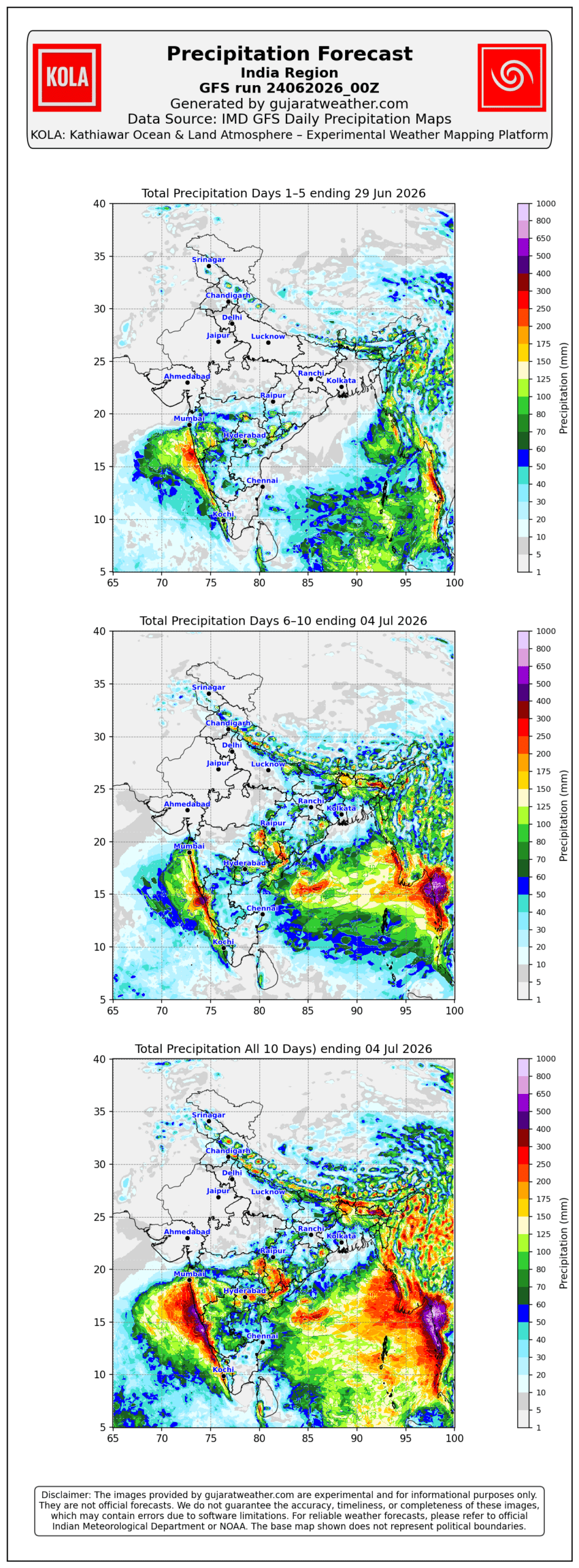
KOLA - India IMD GFS
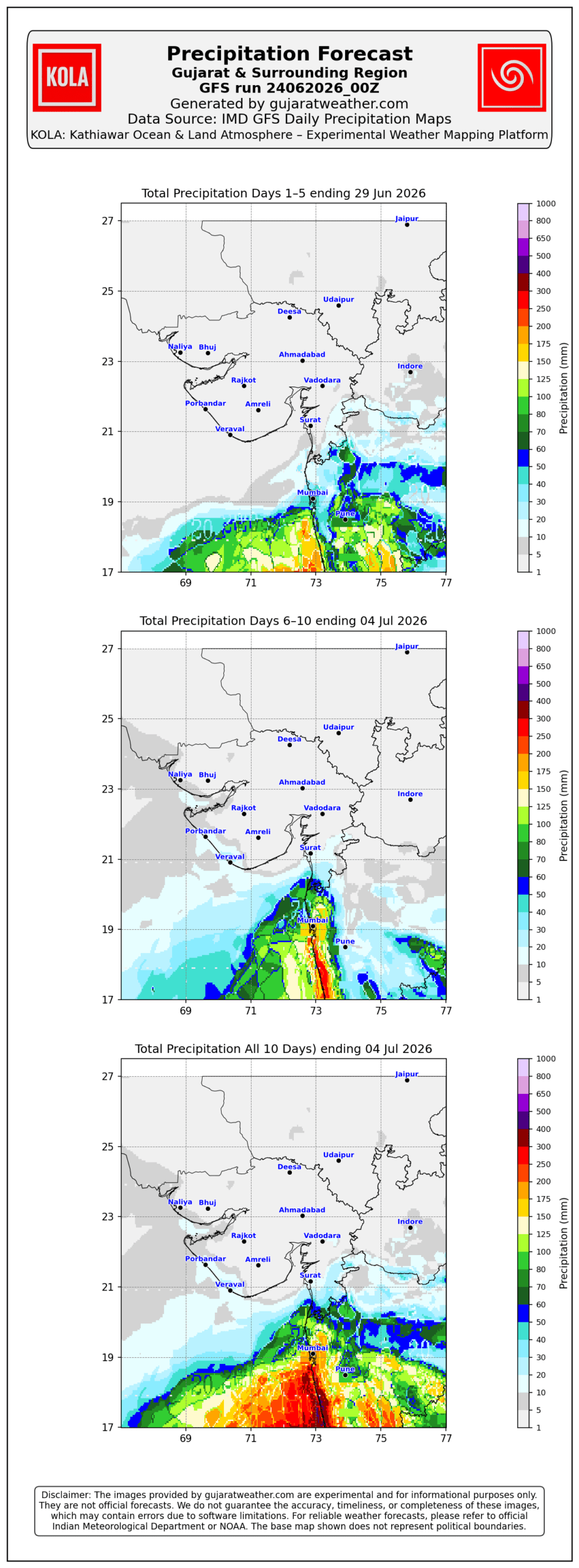
KOLA - West IMD GFS
KOLA - North & Eastern IMD GFS

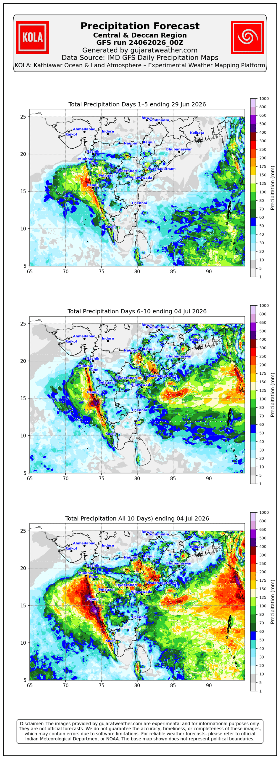
KOLA - C & D IMD GFS
About KOLA
Introducing Kathiawar Ocean & Land Atmosphere – KOLA
Date: 29-06-2025 (Updated 13-12-2025)
GujaratWeather.com is pleased to announce the launch of KOLA – Kathiawar Ocean & Land Atmosphere, a new initiative featuring high-resolution weather forecast maps for Western India and surrounding oceanic regions.
The KOLA series provides composite rainfall forecasts for 7-day and 16-day periods, accompanied by mean sea-level pressure (MSL) overlays on daily maps. The concept draws inspiration from the COLA (Center for Ocean-Land-Atmosphere Studies) weekly rainfall visualization style.
In addition to rainfall analysis, the KOLA platform has been expanded to include daily Maximum/Minimum Temperature and Fog potential forecast maps, offering enhanced insight into weather parameter trends over comparable forecast periods.
KOLA focuses on the dynamic weather patterns of Gujarat, with special emphasis on its two distinct climatic zones: Saurashtra & Kutch and the Gujarat mainland region (comprising North, Central, and South Gujarat). The name KOLA pays homage to the Kathiawar peninsula, the historical name for Saurashtra, which forms the western landmass of Gujarat surrounded by the Arabian Sea. This region’s unique land-ocean interface makes it critical for monsoon forecasting and atmospheric analysis.
With the launch of KOLA images, Gujaratweather.com aims to offer visitors timely, insightful, and visually intuitive rainfall projections that reflect both scientific accuracy and regional identity. Stay tuned as we continue to expand our forecast tools with innovation rooted in geography and heritage.
GujaratWeather.com આનંદ સાથે રજૂ કરે છે નવી પહેલ — KOLA (Kathiawar Ocean & Land Atmosphere) — જે Western India અને તેના આસપાસના Oceanic વિસ્તારો માટે High-Resolution Weather Forecast Maps પ્રદાન કરે છે।
KOLA Series માં 7-day અને 16-day સમયગાળા માટેના Composite Rainfall Forecasts શામેલ છે, જેમાં દરેક Daily Map પર Mean Sea Level Pressure (MSL) પણ દર્શાવવામાં આવે છે. આ કન્સેપ્ટ પ્રસિદ્ધ COLA (Center for Ocean-Land-Atmosphere Studies) ના Weekly Rainfall Visualization Style પરથી પ્રેરિત છે।
Rainfall Analysis ઉપરાંત, KOLA Platform હવે Daily Maximum અને Minimum Temperature Forecast Maps પણ પ્રદાન કરે છે, જેથી સમાન Forecast Periods માટે તાપમાનની પ્રવૃત્તિઓ (Temperature Trends) વિશે વધુ ઊંડાણપૂર્વકની સમજ મળે.
KOLA ના કેન્દ્રમાં ગુજરાતના બે મુખ્ય હવામાન ઝોન છે: સૌરાષ્ટ્ર-કચ્છ અને ગુજરાત રીજિયન (જેમા ઉત્તર, મધ્ય અને દક્ષિણ ગુજરાતનો સમાવેશ થાય છે). KOLA નામમાં રહેલું Kathiawar Ocean & Land Atmosphere નામ સૌરાષ્ટ્રના ઐતિહાસિક મહત્વને ઓળખ આપે છે. સ્વતંત્રતા પૂર્વે સૌરાષ્ટ્રને કાઠિયાવાર રાજ્ય તરીકે ઓળખવામાં આવતું હતું. આ પશ્ચિમી પ્રાંત અરબી સમુદ્રથી ઘેરાયેલો છે અને તેની ભૂ-સમુદ્ર સ્થિતી વરસાદના માળખા અને મોન્સૂન પ્રવાહ માટે અત્યંત મહત્વપૂર્ણ છે.
KOLA ઇમેજીસની સાથે, હવે Gujaratweather.com પર મુલાકાતીઓ સરળ, સમકાલીન અને વિસ્તારપૂર્વકના વરસાદ પૂર્વાનુમાનો જોઈ શકે છે – તે પણ પ્રદેશના ઇતિહાસ અને ભૌગોલિક પૃષ્ઠભૂમિ સાથે સંકળાયેલ નવી દૃષ્ટિ સાથે.