Saurashtra & Kutch Rainfall Prospects Expected to Improve During 12th–16th September 2026 — Forecast for 9th–16th September 2026
સૌરાષ્ટ્ર અને કચ્છમાં 12થી 16 સપ્ટેમ્બર 2026 દરમિયાન વરસાદના સંજોગોમાં સુધારો થવાની શક્યતા — 9થી 16 સપ્ટેમ્બર 2026 માટેની આગાહી
Few parameters from IMD Bulletin — 9th September 2026:
- The western end of the Monsoon Trough is north of its normal position, while the eastern end is near its normal position at mean sea level.
- An upper-air cyclonic circulation lies over north Bay of Bengal & adjoining Bangladesh coast in the lower and middle tropospheric levels. Under its influence, a Low Pressure Area is likely to form over the North Bay of Bengal & neighbourhood around 10th September 2026.
- A trough runs from Rayalaseema to the Gulf of Mannar in the lower tropospheric levels.
- An upper-air cyclonic circulation lies over Saurashtra & neighbourhood in the lower tropospheric levels.
- An upper-air cyclonic circulation lies over north Haryana & neighbourhood in the lower tropospheric levels.
- The Western Disturbance as a cyclonic circulation lies over northwest Uttar Pradesh & neighborhood in the middle tropospheric levels.
Weather Forecast for Saurashtra, Gujarat & Kutch (9th–16th September 2026)
Overall: Rainfall prospects are expected to improve during the forecast period due to the upcoming Low Pressure Area and associated Upper Air Circulation (UAC) at various levels, tilting southwestward with height over Madhya Pradesh and adjoining Maharashtra areas.
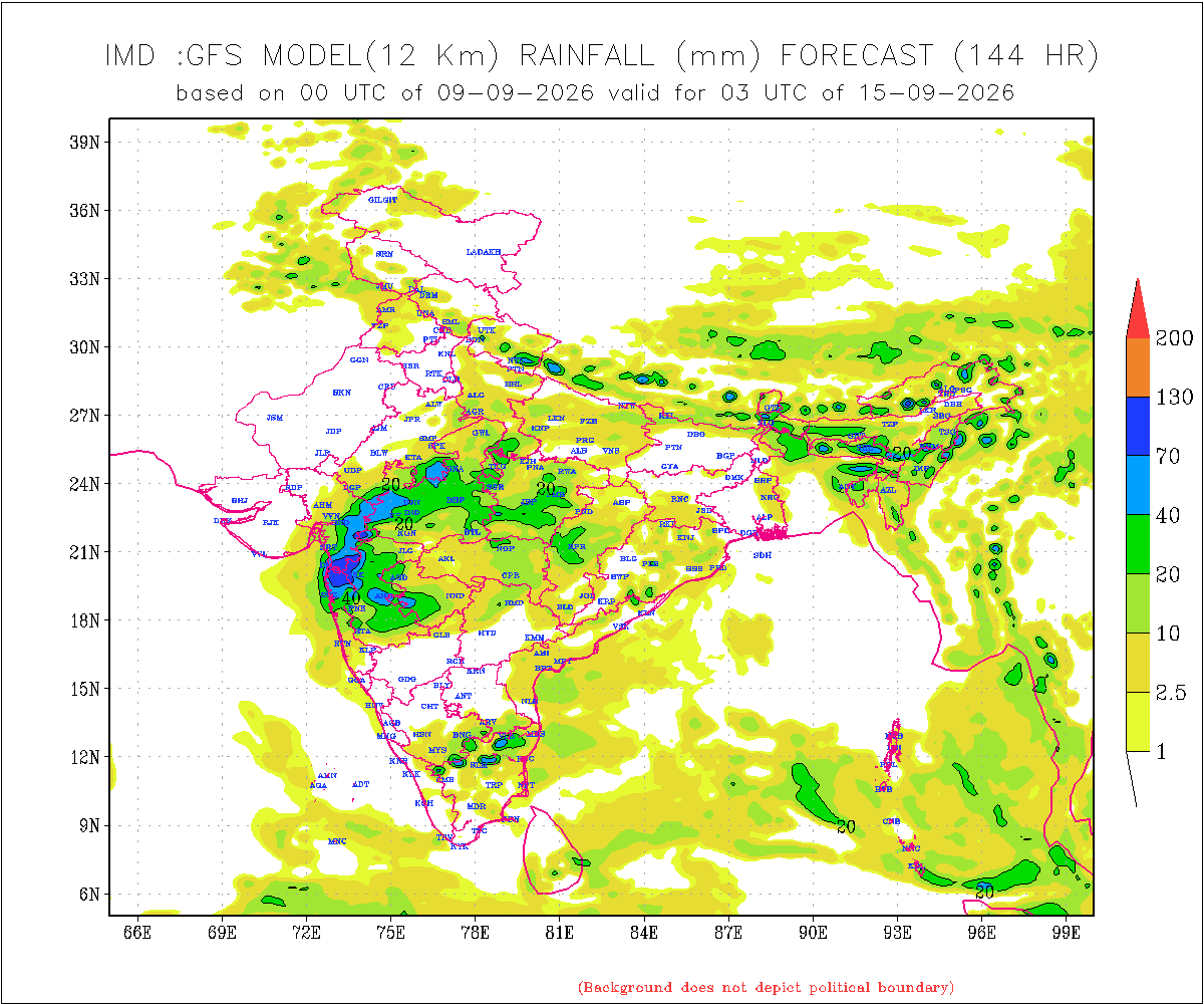
There is a differing outcome in the IMD GFS output from the 09-09-2026 00 UTC run, as well as in the NOMADS GFS for the same run time. These models indicate considerably lower rainfall over Gujarat State compared to various other forecast models, including ECMWF, ICON and other international models.
The rainfall forecast given here is therefore higher than the current IMD GFS model outcome, based on various model guidance regarding the potential Low Pressure Area and its track along with Monsoon trough moving southwards towards normal.
Gujarat Region
- Rainfall: Scattered rainfall is likely over parts of Gujarat Region on different days, mainly during 12th–16th September.
- 50% of the area is expected to receive 20–35 mm of total rainfall during the forecast period.
- The remaining 50% of the area is expected to receive 35–75 mm of total rainfall during the forecast period.
- Isolated locations could receive more than 100 mm of total rainfall.
Saurashtra & Kutch
- Rainfall prospects over Saurashtra & Kutch are expected to improve during 12th–16th September 2026.
- Rainfall: Scattered rainfall is likely on different days of the forecast period, mainly during 12th–16th September.
- 50% of the area is expected to receive 25–50 mm of total rainfall during the forecast period.
- The remaining 50% of the area is expected to receive up to 25 mm of total rainfall during the forecast period.
- Isolated locations could receive more than 100 mm of total rainfall.
Note: When the Low Pressure Area develops over the Bay of Bengal and its initial location becomes established, the above forecast will be revisited if required.
Introducing: KOLA Interactive Rainfall Forecast Atlas
All India States and within each State up to District level Rainfall data is available. Select your State and subsequently all Districts will also be listed within your State in Alphabetical order. This data is based on IMD GFS Daily Precipitation Forecast for 1 to 10 days.
સૌરાષ્ટ્ર અને કચ્છમાં 12થી 16 સપ્ટેમ્બર 2026 દરમિયાન વરસાદના સંજોગોમાં સુધારો થવાની શક્યતા — 9થી 16 સપ્ટેમ્બર 2026 માટેની આગાહી
IMD બુલેટિન — 9 સપ્ટેમ્બર 2026ના કેટલાક મહત્વપૂર્ણ પરિબળો:
- મોન્સૂન ટ્રફનો પશ્ચિમ છેડો તેની સામાન્ય સ્થિતિથી ઉત્તર તરફ છે, જ્યારે તેનો પૂર્વ છેડો સમુદ્ર સપાટી પર તેની સામાન્ય સ્થિતિની નજીક છે.
- નીચલા અને મધ્ય ટ્રોપોસ્ફેરિક સ્તરે ઉત્તર બંગાળની ખાડી અને તેને અડીને આવેલા બાંગ્લાદેશના દરિયાકાંઠા વિસ્તારમાં ઉપરના વાતાવરણમાં ચક્રવાતી પરિભ્રમણ યથાવત્ છે. તેના પ્રભાવ હેઠળ 10 સપ્ટેમ્બર 2026ની આસપાસ ઉત્તર બંગાળની ખાડી અને આસપાસના વિસ્તારમાં લો પ્રેશર એરિયા રચાવાની શક્યતા છે.
- નીચલા ટ્રોપોસ્ફેરિક સ્તરે રાયલસીમાથી ગલ્ફ ઑફ મન્નાર સુધી ટ્રફ વિસ્તરેલો છે.
- નીચલા ટ્રોપોસ્ફેરિક સ્તરે સૌરાષ્ટ્ર અને આસપાસના વિસ્તારમાં ઉપરના વાતાવરણમાં ચક્રવાતી પરિભ્રમણ યથાવત્ છે.
- નીચલા ટ્રોપોસ્ફેરિક સ્તરે ઉત્તર હરિયાણા અને આસપાસના વિસ્તારમાં ઉપરના વાતાવરણમાં ચક્રવાતી પરિભ્રમણ યથાવત્ છે.
- મધ્ય ટ્રોપોસ્ફેરિક સ્તરે વેસ્ટર્ન ડિસ્ટર્બન્સ તરીકેનું ચક્રવાતી પરિભ્રમણ ઉત્તર-પશ્ચિમ ઉત્તર પ્રદેશ અને આસપાસના વિસ્તારમાં યથાવત્ છે.
સૌરાષ્ટ્ર, ગુજરાત અને કચ્છ માટે હવામાન આગાહી (9થી 16 સપ્ટેમ્બર 2026)
એકંદરે: આગાહી સમયગાળા દરમિયાન વરસાદની સંભાવનાઓમાં સુધારો થવાની શક્યતા છે. તેનું મુખ્ય કારણ આગામી લો પ્રેશર એરિયા અને વિવિધ સ્તરે તેની સાથે સંકળાયેલું અપર એર સાયક્લોનિક સર્ક્યુલેશન (UAC) છે, મધ્ય પ્રદેશ અને તેને અડીને આવેલા મહારાષ્ટ્રના વિસ્તારો પર, જે વધતી ઉંચાઈએ દક્ષિણ પશ્ચિમ તરફ ઝુકે.
09-09-2026 00 UTCના IMD GFS આઉટપુટ તેમજ સમાન રન સમયના NOMADS GFSમાં વરસાદના પરિણામમાં તફાવત જોવા મળે છે. આ મોડેલો અન્ય વિવિધ આગાહી મોડેલો, જેમાં ECMWF, ICON અને અન્ય આંતરરાષ્ટ્રીય મોડેલોનો સમાવેશ થાય છે, તેની સરખામણીએ GFS ગુજરાત રાજ્યમાં નોંધપાત્ર રીતે ઓછો વરસાદ દર્શાવે છે.
આથી અહીં આપવામાં આવેલી વરસાદની આગાહી હાલના IMD GFS મોડેલના પરિણામ કરતાં વધુ છે. આ આગાહી સંભવિત લો પ્રેશર એરિયા અને તેની ટ્રેક અંગેના વિવિધ મોડેલ માર્ગદર્શન, તેમજ મોન્સૂન ટ્રફના દક્ષિણ તરફ ખસીને તેની સામાન્ય સ્થિતિ તરફ જવાના વલણને ધ્યાનમાં રાખીને કરવામાં આવી છે.
ગુજરાત રિજન
- વરસાદ: ગુજરાત રિજનના કેટલાક વિસ્તારોમાં અલગ-અલગ દિવસોમાં છૂટાછવાયા વરસાદની શક્યતા છે, ખાસ કરીને 12થી 16 સપ્ટેમ્બર દરમિયાન.
- આગાહી સમયગાળા દરમિયાન 50% વિસ્તારમાં કુલ 20–35 મિમી વરસાદ થવાની શક્યતા છે.
- બાકીના 50% વિસ્તારમાં કુલ 35–75 મિમી વરસાદ થવાની શક્યતા છે.
- આઇસોલેટેડ સ્થળોએ કુલ વરસાદ 100 મિમીથી વધુ થઈ શકે છે.
સૌરાષ્ટ્ર અને કચ્છ
- 12થી 16 સપ્ટેમ્બર 2026 દરમિયાન સૌરાષ્ટ્ર અને કચ્છમાં વરસાદની સંભાવનાઓમાં સુધારો થવાની શક્યતા છે.
- વરસાદ: આગાહી સમયગાળા દરમિયાન અલગ-અલગ દિવસોમાં છૂટાછવાયા વરસાદની શક્યતા છે, ખાસ કરીને 12થી 16 સપ્ટેમ્બર દરમિયાન.
- આગાહી સમયગાળા દરમિયાન 50% વિસ્તારમાં કુલ 25–50 મિમી વરસાદ થવાની શક્યતા છે.
- બાકીના 50% વિસ્તારમાં કુલ 25 મિમી સુધી વરસાદ થવાની શક્યતા છે.
- આઇસોલેટેડ સ્થળોએ કુલ વરસાદ 100 મિમીથી વધુ થઈ શકે છે.
નોંધ: બંગાળની ખાડી પર લો પ્રેશર એરિયા રચાય અને તેનું પ્રારંભિક સ્થાન સ્પષ્ટ થાય ત્યારબાદ, જરૂર જણાય તો ઉપરોક્ત આગાહીની પુનઃસમીક્ષા કરવામાં આવશે.
પરિચય: KOLA Interactive Rainfall Forecast Atlas
ભારતના તમામ રાજ્યો તેમજ દરેક રાજ્યના જિલ્લા સ્તર સુધીના વરસાદના અનુમાન ઉપલબ્ધ છે. તમારું રાજ્ય સિલેક્ટ કરો અને પછી દરેક ડીસ્ટ્રીકટ ના આંકડા ઉપલબદ્ધ થશે અલ્ફાબેટિક ક્રમ માં. આ માહિતી IMD GFS મોડેલના 1 થી 10 દિવસના દૈનિક વરસાદ (Daily Precipitation)ના ફોરકાસ્ટ અનુમાન પર આધારિત છે.
Caution: Please refer/rely on IMD/RSMC Bulletins/Advisories for Storms & Weather related matter.
સાવચેતી: સ્ટોર્મ કે હવામાન અંગે ની માહિતી માટે ભારતીય હવામાન ખાતા/ગવર્મેન્ટ ના બુલેટીન/સુચના પર નિર્ભર રહેવું.
Read Comment Policy – કમેન્ટ માટે માર્ગદર્શન વાંચો
How To Upload Profile Picture For WordPress – વર્ડપ્રેસ માં પ્રોફાઈલ પિક્ચર કેમ રાખવું
Forecast In Akila Daily Dated 9th September 2026
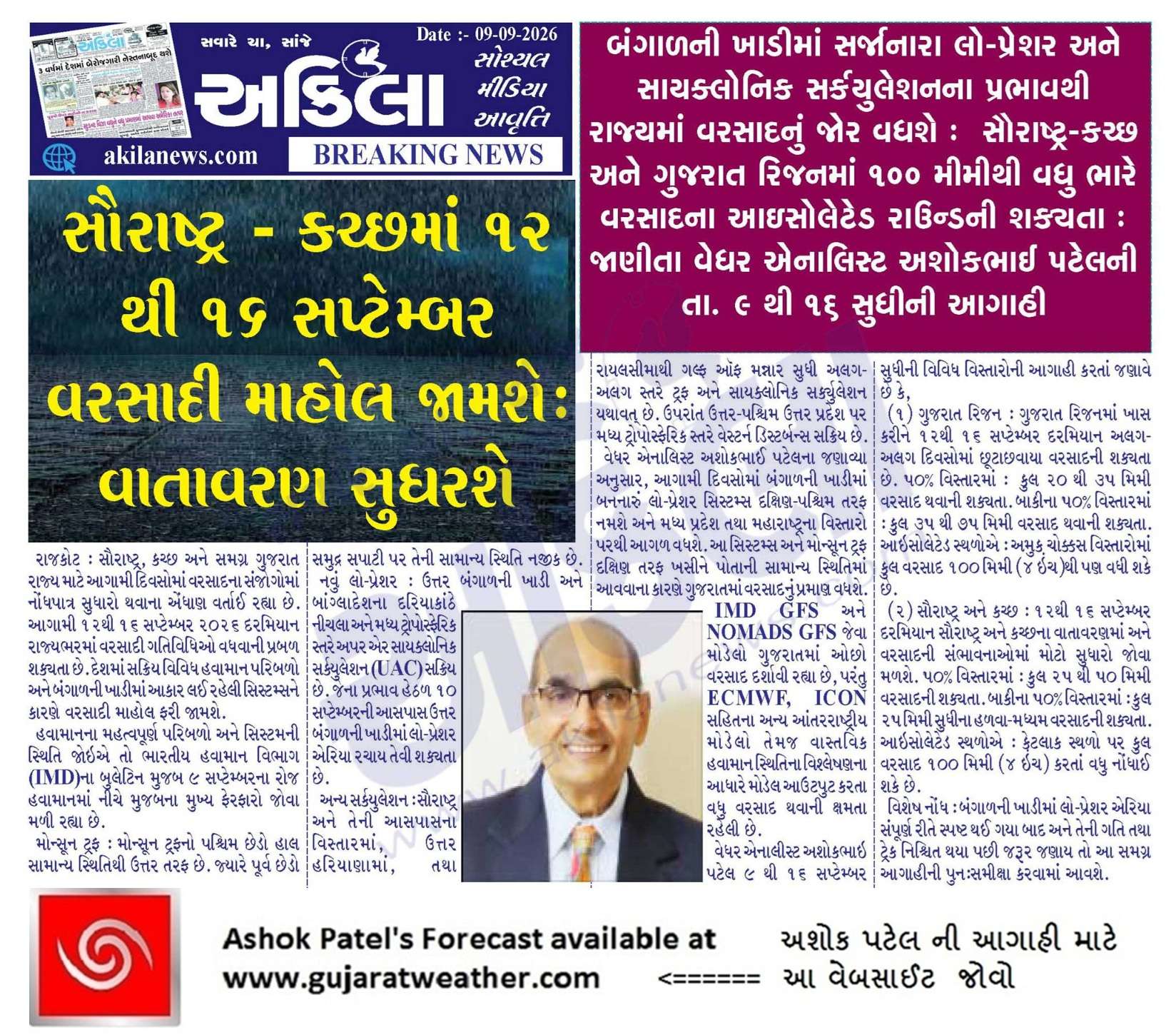
Pending Forecast In Sanj Samachar Daily Dated 9th September 2026
KOLA Interactive Rainfall Forecast Atlas
Jsk Sir,
આગાહીની પુનઃસમીક્ષા કરવામાં આવશે.
Have kari dyo…….ne.
tuit kartar thati bandh thai amne.
Sir, western end monsoon trough is in higher position, how new system will reach gujarat? Shall it come down within 2-3 days?.
Monsoon trough at Sea Level and 0.75 Km above msl normally jovatu hoy.
Pan Anusangik UAC jovo je M.P. par and higher level ma M.P./Maharashtra par
સર હવે તો આઈ એમ ડી પણ જાગી ગયું સૌરાષ્ટ્ર માટે. હવે તો સિસ્ટમ સૌરાષ્ટ્ર ઉપર આવશે એવી સેટેલાઈટ આઈએમડી દેખાડી રહ્યું છે. સર હવે વરસાદની માત્રામાં વધારો થશે ને.
IMD ma ketla vistar ma ketlo batavey chhe ?
સૌરાષ્ટ્રનો 90% વિસ્તાર. પણ પહેલા આઇએમડી એટલું બધું નહોતું બતાવતું હવે તે પોઝિટિવ થયું એવું લાગે છે.
KOLA IMD GFS Update thai gayu. 11-09-2026 00UTC
મુખ્ય ત્રણ મોડલ ECMWF, GFS, IMD GFS,ની વાત કરીએ તો… ગઈ કાલે બનેલ લો પ્રેશર ને મધ્ય પ્રદેશ..ગુજરાત રાજસ્થાન ની બોર્ડર આસપાસ સુધી લઈ આવે છે મોન્સુન ટ્રફ પણ નોર્મલ કે તેનાથી નીચે સુધી આવતો બતાવે ..પરંતુ imd હજુ સુધી લેખિત માં નથી કહેતા કે મોન્સુન ટ્રફ નીચે આવશે(ફોરકાસ્ટ રૂપે) મજબૂતાઇ પણ ત્યાં સુધી એટલે તા.૧૪/૯ સાંજ સુધી સેમ જેવું લાગે છે… ફરક ત્યાંથી થાય છે..gfs અને imd gfs સિસ્ટમ ને ત્યાં નબળી કરી ને માત્ર uac સ્વરૂપે બતાવે છે અને તેનો ટ્રફ ત્યાંથી લઈને છેક દક્ષિણ સૌરાષ્ટ્ર થી અરબ સાગર સુધી લંબાવે છે …વધુ ઉતર પશ્ચિમ માં ચાલે એવું… Read more »
Sau koi ne ECNWF mujab chaley tevi apexsha chhe.
100% visvas che
તમારુ મંતવ્ય જણાવો
Mantavya etle Update !
Hu ichhchu chhu ECMWF
Sir jarur Hoy tyare badhane sari j asha hoy etle ECMWF par vadhare bharoso Che Jo ECMWF sachu pdi Jay Dwarkadhish Ni maher thay Jay to saru joi have Shu thay Che
Gsf pan positive thayu have extremely heavy rein ni coment na thagala thase
Sir aa system saurashtra uper thi pasar thase teni speed vadhu hse ne?
System etle?
Media ma 3 -3 System chhe !
All models becoming positive for good rainfall from 13th to 15th sept except Windy GFS.
WIndy ma GFS ke koi pan Model nu Forecast run check karo.
Em nem comment matlab vagar ganay.
GFS tamo jovo chho te gai kaal sanje 12 UTC nu chhe
Aajnu aavey tyare jovo
KOLA monthly IOD graph update thayo..very Good sir
Aajni ni uodate ma Ecmwf pan thoduk nabalu padyu sir… Jay Shree Radhe Krishna Ji…
તો શુ દિલીપભાઈ વરસાદ નહિ આવે
ECMWF ni kya RUN time ni update ni Vaat karo chho?
આમાં કેમ ભેગું કરવું એક 13 ઇંચ માં છે ને એક 13mm માં……..!!!! ?
Average kari levi
જય મુરલીધર સાહેબ
મોડલો નો મતમતાંતર આટલું નજીક ગયા પછી પણ કેમ એક નથી થતા આ વર્ષે અમારા વિસ્તારમાં ઈ સી એમ પરફેક્ટ રહ્યું છે ૭૦૦ એસ પી મુજબ એ પ્રમાણે અમારા વિસ્તારની ભુખ ભાંગી જાય પણ જી એસ એફ હજુ કંજુસાઈ કરે છે
શક્ય હોય તો આપનો અભિપ્રાય આપવા વિનંતી
Hu badha Model ni SODA lemaon karu chhu.
Aapadey jarur c hhe ECMWF mujab etle West Saurashtra ni bhukh bhangey.
Sir ECMWF mujab varsad thase karan ke ECMWF 90% accurate che varsadi system track karwa babate
Jsk સર… પણ આ વખતે વરસાદ ની માત્રા માં સોડા લેમન કરવામાં પણ કન્ફ્યુજન છે
અમારા લોકેશન પર Gfs 3 mm…. Ecmwf 400+ mm… Icon 150+ mm બતાવે છે… જો આમાં પણ સોડા લેમન કરતા હાલી જાય તો પણ 200 mm ભાગમાં આવે પણ તમારી આગાહી 25/50 mm ની છે એટલે વિચારમાં પડી ગ્યા અમે તો બધા…. શક્ય હોય તો જવાબ આપજો સાર્વત્રિક આવશે તો ખરોને પછી ભલે જે ભાગમાં આવે ઇ બીજું હું પણ એટલીસ્ટ વરસાદ વરહતો જોવા તો મળશે અવાર ની સીઝન માં
Isolated etle shu te check kari levu
Saurashtra: આઇસોલેટેડ સ્થળોએ કુલ વરસાદ 100 મિમીથી વધુ થઈ શકે છે.
Jsk સર…. હા ઈતો વાંચ્યું પણ ઇમ થાય કે ઈમા તો ક્યાંથી આવીયે… આખા વરહ માં નથી એટલે બીક બોવ લાગેહ
1 thi 25% vistar (Isolated)
Sar kale 3pm thi 6:30 sudhi saro varsad padiyo amare
બધા મોડલ પોઝીટીવ થવા મડિયા
2026 na ચોમાસાના ekey system atyar sudhima gujrat saurastra upar nati avi atale akey agahi karo avnari system upar visvas nathi have upar varo કરે a sachu
ગુરુજી પ્રણામ
Ecmwf icon મોડલો ચાર પાંચ દિવસ થી પોઝિટિવ બતાવે છે GFS IMD પોઝિટિવ નથી પણ એ પણ આજે થોડા પોઝિટિવ બાજુ આવે છે તો હવે તમે કહેલ તેમ જરુર લાગે તો અપડેટ આપીશ તો હવે માત્રા મા વધારો થય શકે અને લો પ્રેશર સિસ્ટમ પણ બની તો હવે તેનો ટ્રેક પણ ફાયનલ થય શકે તો ગુરુજી જણાવો કેવો ફેરફાર થય શકે
Sir varsad ni matra Kem vadhu pade aem lage che khas Kari ne porbandar distik baju please ansar aapva vinati
ECMWF ma chhe
Ashok sir paka sing & sika kyare karso
Update aapel j chhe.
fer faar hashe etle aavshe.
સર gsf ની તાજી અપડૅટ માં ઘૂમરી સૌરાષ્ટ્ર માં બતાવે છૅ તો હવે ફાયનલ ગણાય
Taji etle kya time ni and kya level ma ?
Windy 5.30pm
Varsad chhe tema?
Ha
700hpa
Screenshot ma date nathi time 10 AM chhe.
Ahi kahyu chhe ke jeni ghumari jovo chho tema Varsad batavey chhe ?
Dt 14 dekhay chhe
Yes Zoom karyu etle dekhanu.
આજે અમારો વિસ્તાર જેવો કે અમારા ગામ હાથીગઢ માં તથા લીલીયા .ગારીયાધાર ,સાવરકુંડલા પંથકમાં ખૂબ સારો વરસાદ વરસી ગયો. તારીખ 10-9-26
G f s હવે ઠેકાણે આવ્યુ સરમાતા સરમાતા
Bhubaneswar, Odisha najik lps banu che je 48 hours ma west baju gatiman thase
સર ecmwf ની હાલ નિ અપડેટ જોતા તો આંનદ્દો ની મહોર લગાડવી જોઈએ તમારે
પણ gsf હજી બીવડાવે છે
સાહેબ ગણાય મોડલો માં તેમજ ઘણા આગાહી કાર (તેમાં તમે પર સામેલ) ગુજરાત માં ડિપ્રેશન અથવા ડિપડિપ્રેશન સુધી સીસ્ટમ પહોંચી જશે અને 5 ઈંચ થી માંડીને 10 ઈંચ સુધી નો વરસાદ બતાવે છે તે ગુજરાત નાં ખેડૂત મિત્રો માટે સારી બાબત છે પર પ્રશ્ન એ થાય છે કે આપણું ભારતીય હવામાન વિભાગના IMD મુજબ આટલું વરસાદ કે મજબૂત સીસ્ટમ ગુજરાત પર બતાવતું નથી આગાહી ની નીચે IMD નાં બુલેટીન પર નિરર્ભર રહેવું કે આત્મનિર્ભર બનવું
સુ કહેવા માંગો છો તે પ્રશ્ન સ્પષ્ટ નથી સમજાતો
Tarikh 12 thi 16 ma Gsf AK j nabalu se baki badha ecmwf, icon, gem,acc,jam, UK, US, badha paschim saurastra sudhi bhuka bolave se GSF ma j atalo fer kem hase najikana divas hova chata.
તો કેડી ભાઈ આમા આપણે શુ માનવાનુ જણાવશો
windy ma ecmf and gfs bane ma varsad babat vad ghat ghani chhe aenu su karan..?ecmf saru batave gfs sav occhu
Te Babat te Model Maliko ne khabar hoy !
ECMWF બવ જાડુ કરી દીધું અત્યાર ની અપડેટ માં તો
PORBANDAR !
એ લોકો એ જોયો પણ નથી ને ઓણ, ભેગો આપી દેશે એવું લાગે છે
Ha sir amne hve asha che amare Porbandar ma varsad ni Ghat puri thase aa Session ma Pehli vaar Model west saurashtra mate positive thya che.Sir Ni ek j vastu yaad rakhvani Chomasu chalu che tya sudhi badhu j possible hoi che.
ભલે આવે સાહેબ આવવા દિયો મગફળી પાક ઉપર છે.છતા ભલે આવે ઠાકર લેખે જી થાય ઈ
Sir amare…savar thi bapor sudhi ma…25 mm jevo varsad
Thanks sir for new update
Windy model ma low pachhu fartu dekhay chhe sir.
Jo evu thase to vadhu labh male em chhe sir.
Wait and watch jevu chhe
ECMWF ma kal thi pan aaj kalar vadhyo e pamane aave to moj padi jay sir
તારીખ:- 10 સપ્ટેમ્બર 2026 આજની પરિસ્થિતિ ભારતીય હવામાન વિભાગ અનુસાર મીડ ડે બુલેટિન – ઉત્તર બંગાળની ખાડી અને આસપાસના વિસ્તારો પરનુ લો પ્રેશર એરિયા આજે, 10 સપ્ટેમ્બર 2026ના રોજ ભારતીય સમય મુજબ સવારે 08:30 વાગ્યે ઉત્તર-પશ્ચિમ બંગાળની ખાડી અને આસપાસના વિસ્તારો પર સ્થિત છે. તેની સાથે જોડાયેલું સાયક્લોનિક સર્ક્યુલેશન સરેરાશ દરિયાઈ સપાટીથી 9.4 કિમી ઊંચાઈ સુધી વિસ્તરેલું છે અને ઊંચાઈ સાથે દક્ષિણ-પશ્ચિમ તરફ નમેલું છે. – ઉત્તર હરિયાણા અને આસપાસના વિસ્તારો પરનુ UAC હવે ઉત્તર-પશ્ચિમ ઉત્તર પ્રદેશ પર સ્થિત છે અને તે સરેરાશ સમુદ્ર સપાટીથી 3.1 કિમી સુધી વિસ્તરે છે. – એક ટ્રફ હવે ઉત્તર હરિયાણાથી ઉત્તર પ્રદેશ અને ઝારખંડ… Read more »
Gsf ને કોક માર્ગદર્શન કરો ભૂલું પડી ગયું છે
એની મશનરી માં કાટ લાગી ગયો હોય એવું લાગે છે
Gfs નો કાટ ઉછળી જશે ને આપણો કાટ ઉખેળી નાખશે
સર સોશિયલ મીડિયા માં તો મોટી.જાન પયણવા આવે હૈ એવા ધુબાકા થાય હૈ ?
925અને ૮૫૦hpa લેવલ ની ઘૂમરી ગુજરાત પાસે આવીને ઉત્તર તરફ ફંટાઈ જાય છે અને ૭૦૦અને ૫૦૦લેવલ ની ઘૂમરી ગુજરાત ઉપર થી પસાર થઈ છે તો આપણે કયા લેવલ નો વરસાદ આવી શકે
Ghumari Ghumari ma farak hoy.
Badha Model ni Ghumari alag alag time ma alag alag jagyaye hoy.
Tamari Ghumari kya Model ni chhe ?
te joiy ne shu kadhi levanu chhe ?
Tamara Model ma Varsad je Batavey te final hoy tamara Model maate. Pachhi tamara Model ni Ghumari pachhad shu kam Ghumo chho ?
સર કોઈ પણ મોડલ મા ઘુમરી કે ભેજ જોવા કરતા ડાયરેક્ટ વરસાદ જોઇએ તો સચોટ અનુમાન કરી શકીએ??
Yes
Windy માં accumulated rain જોવો એટલે ૪-૬ દિવસનો કુલ વરસાદ બતાવે.
Sir tamari site kholi to બિનજરૂરી add ave chhe hamna hamna possible hoi to bandh karavo..
Ahi badhu mafat chhe.
Imd ek fresh western disturbuns nu pan ullekh kare che to sir ae kevo bhag bhajvase aavnara divaso ma saurashtra mate aavnara varsad ma.
IMD na morning bulletin mujab low pressure bani chukyu che.
Jsk Varsad premi mitro. ECMWF update jot……… halva jai ne haddi kadhay jay che
જયશ્રી કૃષ્ણ ધીરેનભાઈ , આજના રેળા તમારે કેવાક છે ? એ બાજુ સવારથી બપોર સુધી એક પછી એક રેળા મંડાણા હતા , અમારે તો ગામની આથમણી એક સાઈડ ઘસાતા ઘસાતા સારા એવા ત્રણ રેળા પાણી કાઢી નાખે એવા આવ્યા ”વધારે તો ભીમોરા ‘ કુંઢેચ ‘કાથરોટા ‘ સમઢીયાળા ‘ ઉપલેટા એ બાજુ ‘ કાલથી મેળો ચાલુ મેળો કરવા બધા પુગી જાજો
amare Nil/sannata till time.
Vatavaran jaklai gayu che. aasha rakhi ઉપરોક્ત આગાહીની પુનઃસમીક્ષા કરવામાં આવશે. ane More moro dabe.
Jsk bhai upleta ma savar thi sara Reda aave che bapor na 2 vagya sudhi atyare 2 vagya pachi nathi
Jsk bhai tamare Bhayavadar ma kevuk che varsadi vatavaran
અશોકભાઈ આ વરસે IMD GFS ક્યારેય ફોમ માં આવ્યું નથી કોલામા કલર પુરાણો જ નહીં
WD active takat ne lidhe system pachi dhakele che avu imd gfs nu manvu che atle avu thai che
મિત્રો જ્યારે જયારે સાહેબ નવી આગાહી આપે છે ત્યારે એમના ફોટા સાથે ખોટી આગાહી વાયરલ થાય છે.. એટલે ખોટી માહીતી થી ધ્યાન દોરવા માટે અહીં આ ફોટો મુકું છુ. બધા બને એટલી લોકો સુધી સાચી માહીતી પહોંચે એવો પ્રયાસ કરીયે
સર હજી imd gfs ઓછુ પોઝિટિવ છે
નવી અને સચોટ અપડેટ માટે ખૂબ ખૂબ આભાર સાહેબ… ભાદરવા ના અડબાવ ભીંડા ની જેમ ઊગી નીકળેલા આગાહી કારો એ ભ્રમિત કરી દીધા હતા…
IMD em maney chhe haal ke System Gujarat baju aavey tyare WD ni asar this break maarey (ubhi rahe…pachhi WD jitey evu maaney chhe)
Aa badhu Low pressure timing oopar hoy.
WD and Low pressure timing ma ek divas ke 12 kalak farak ma alag Parinam aavey.
Etle j lakhvu padyu ke Low Pressure thay pachhi koi fer far lagshe toe update aapvama avashe.
ધન્યવાદ. સરસ.
Sir WD jota nathi aavadtu to time hoy tyare shikhvad jo
Pakistan bajuthi North ma WD etle UAC je Pashchim thi poorva baju jatu hoy chhe.
સર આવનારી સિસ્ટમ ધારણા કરતા વધુ મજબૂત બની અને સૌરાષ્ટ્રમા આવતા આવતા ડિપ્રેશન કે ડીપડિપ્રેશન સુધી જઈ શકે..?
Pahela te System janmey tyare teni ‘Chhaththi’ na lekh lakhayne ?
સરસ જવાબ આપ્યો સર
Dwarka porbandr vara tayat rejo 6 inch varsad lakhi lejo 13 thi 23 sudhi ma
સર તમારી પાસે થી જવાબ ની આશા સાથે એક સવાલ…
imd પર તમને કેટલા % ભરોસો?
Varsho thaya mari update ma 60% IMD hoy and 40% bija Model hoy.
IMD GFS model chhe pan tema IMD nu potanu pan amuk processing hoy chhe evu maney khyal chhe.
Aa Saal IMD 40% use karu chhu and 60% bija model. (SODA Lemon)
ખૂબ ખૂબ આભાર સર નવી અપડેટ બદલ સર ફરી એક કે બે દિવસ માં વધુ ઇંચ ના આંકડા વારી અપડેટ ની આશા
સુરેન્દ્રનગર ના ચુડા તાલુકા મા વરસાદ ને પવન કેવો રહેસે
સર પવનની ગતિ કેવી રહી શકે 12.13.14.તારીખ માં
14-16 ma vadhu
દરેક વખતે સિસ્ટમ પોરબંદર જિલ્લાને છોડી દે છે એટલે એવું ઇચ્છીએ કે આ વખતે પુનરાવર્તન ન થાય
અપડેટ માટે આભાર સાહેબ
ECMWF, EC-AIFS, ICON models મુજબ આ વખતે સિસ્ટમ સૌરાષ્ટ્ર ને વીંધી ને અરબી સમુદ્ર તરફ જાય છે. જો તેમ થાય તો સમગ્ર સૌરાષ્ટ્ર માં વ્યાપક રીતે ભારે વરસાદ થશે.
Fasten your seatbelts!