Monsoon Expected To Progress Over Gujarat Region & Enter Saurashtra & Kutch Zone During Forecast Period 1st-8th July 2026
Advance of Southwest Monsoon 2026
Some conditions as per the IMD Bulletin:
- The Northern Limit of Monsoon (NLM) continues to pass through 20°N/60°E, 20°N/65°E, 20°N/70°E, Surat, Indore, Mandla, Daltonganj, Motihari and 28.3°N/83°E.
- Conditions are favorable for the further advance of the Southwest Monsoon into some more parts of the North Arabian Sea, Gujarat, Madhya Pradesh, remaining parts of Chhattisgarh, Jharkhand & Bihar, and parts of Uttar Pradesh & Uttarakhand during the next two days, and thereafter into some more parts of Madhya Pradesh, Uttar Pradesh, Uttarakhand, parts of Himachal Pradesh, Jammu & Kashmir, Ladakh, southeast Rajasthan and the remaining parts of Gujarat during the subsequent 2–3 days.
- The seasonal trough at mean sea level from Punjab to Bihar across Haryana and Uttar Pradesh persists.
- The trough extending from north-central Madhya Pradesh to the East-Central Arabian Sea across north Maharashtra persists and is now seen between 4.5 km and 5.8 km above mean sea level.
- An upper air cyclonic circulation (UAC) lies over north Odisha and neighborhood at 5.8 km above mean sea level.
- Another upper air cyclonic circulation lies over the north Bay of Bengal adjoining south Bangladesh between 1.5 km and 5.8 km above mean sea level.
- An upper air cyclonic circulation lies over Saurashtra at 3.1 km above mean sea level.
Expected Parameters:
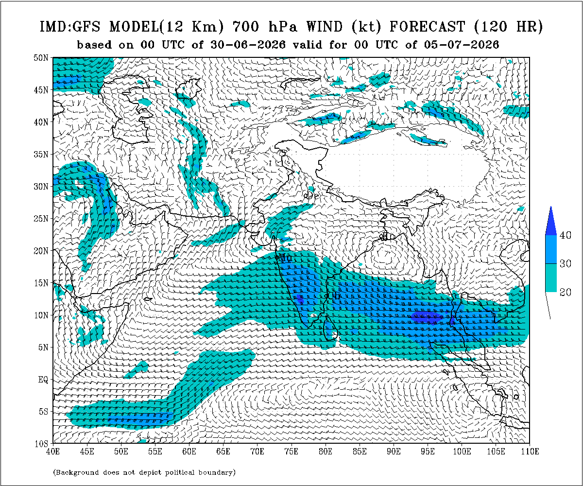
Multiple Upper Air Cyclonic Circulations (UACs) are expected to develop, and at times may combine into a broader circulation. An east-west shear zone extending from Gujarat to West Bengal across Central India is also expected to develop. The distribution and intensity of rainfall will depend on the day-to-day evolution of these weather systems.
Weather Forecast for Saurashtra, Gujarat & Kutch (1st–8th July 2026)
Gujarat Region:
- Scattered to fairly widespread light to moderate rainfall on many days.
- Heavy to very heavy rainfall is likely on a few days.
- Thunderstorms, lightning and gusty winds of 40–50 kmph are likely at times.
Expected Total Rainfall Distribution
- 10% of the area: Up to 25 mm
- 30% of the area: 25–75 mm
- 60% of the area: 75–150 mm, with isolated places exceeding 250 mm
Saurashtra & Kutch
- Scattered light to moderate rainfall during the period.
- Isolated heavy to very heavy rainfall is likely on a day or two
- Thunderstorms, lightning and gusty winds of 40–50 kmph are likely at times.
Expected Total Rainfall Distribution:
- 25% of the area: Up to 25 mm
- 50% of the area: 25–75 mm
- 25% of the area: Above 75 mm, with some centers exceeding 150 mm
Summary:
- The Southwest Monsoon is expected to make further progress across Gujarat Region and advance into Saurashtra & Kutch during the forecast period.
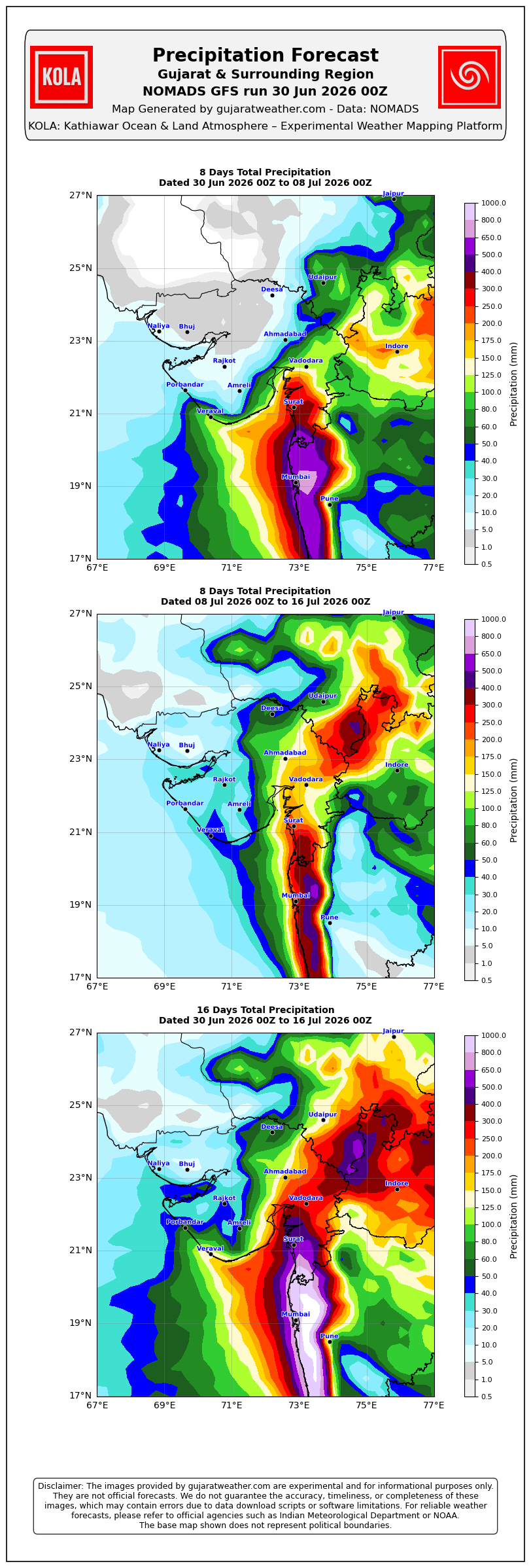
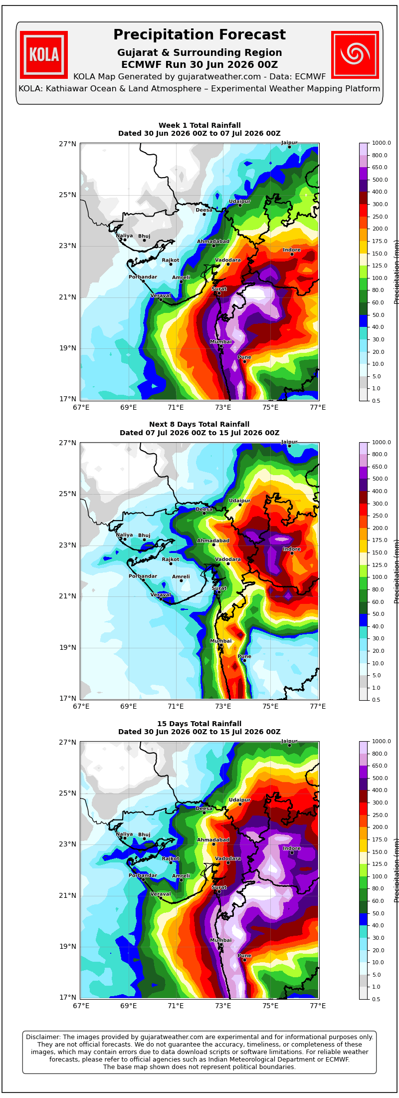
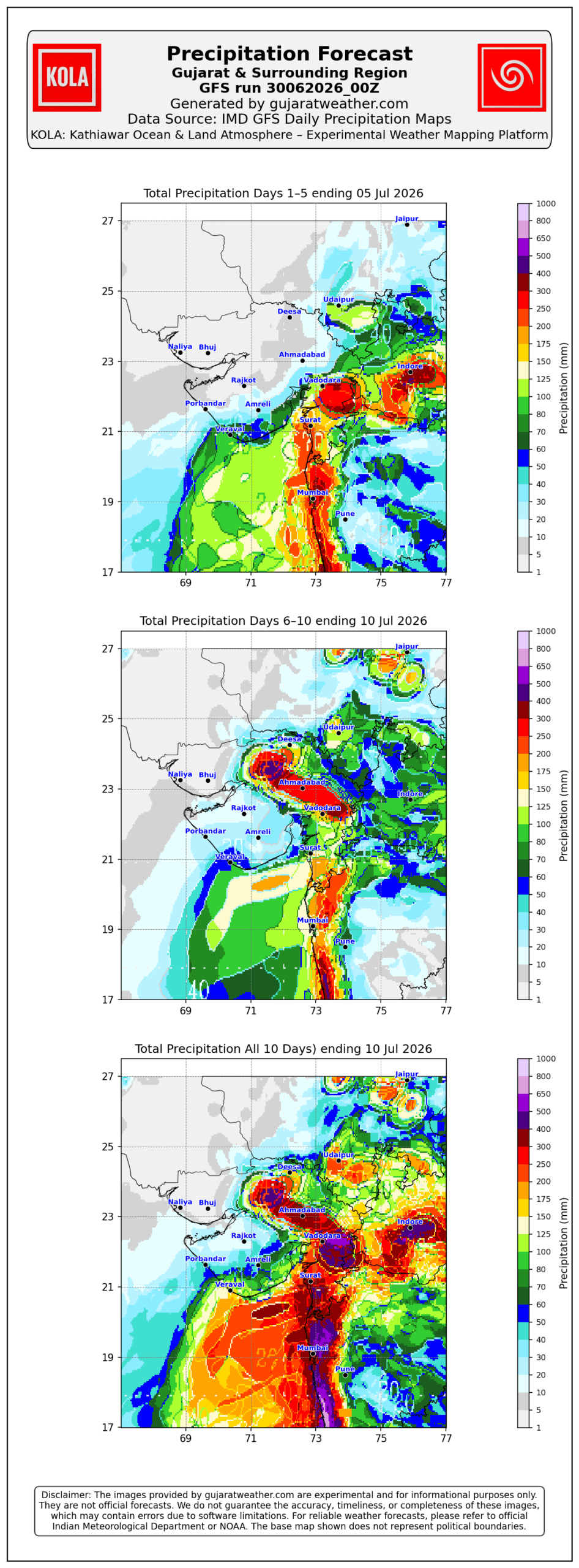
- Rainfall coverage and overall rainfall amounts are expected to increase across the entire State from 3rd July onward and will be significantly higher over Gujarat Region than over Saurashtra & Kutch.
Please refer to the maps given below for the supporting indications.
1 થી 8 જુલાઈ 2026 દરમિયાન ચોમાસું ગુજરાત રિજિયનમાં આગળ વધવાની તથા સૌરાષ્ટ્ર-કચ્છ ઝોનમાં પ્રવેશવાની શક્યતા
દક્ષિણપશ્ચિમ ચોમાસું 2026ની પ્રગતિ
IMD બુલેટિન મુજબ કેટલીક મુખ્ય પરિસ્થિતિઓ:
❖ ચોમાસાની ઉત્તર સીમા (Northern Limit of Monsoon – NLM) હાલ 20°N/60°E, 20°N/65°E, 20°N/70°E, સુરત, ઇન્દોર, મંડલા, ડાલ્ટનગંજ, મોતિહારી અને 28.3°N/83°E પરથી પસાર થાય છે.
❖ આગામી 2 દિવસ દરમિયાન દક્ષિણપશ્ચિમ ચોમાસું ઉત્તર અરબી સમુદ્રના વધુ ભાગો, ગુજરાત, મધ્ય પ્રદેશ, છત્તીસગઢના બાકીના ભાગો, ઝારખંડ, બિહાર તથા ઉત્તર પ્રદેશ અને ઉત્તરાખંડના કેટલાક ભાગોમાં આગળ વધવા માટે પરિસ્થિતિ અનુકૂળ છે. ત્યારબાદના 2–3 દિવસ દરમિયાન મધ્ય પ્રદેશ, ઉત્તર પ્રદેશ, ઉત્તરાખંડના વધુ ભાગો, હિમાચલ પ્રદેશ, જમ્મુ-કાશ્મીર, લદ્દાખ, દક્ષિણ-પૂર્વ રાજસ્થાન તથા ગુજરાતના બાકીના ભાગોમાં આગળ વધવાની શક્યતા છે.
❖ સમુદ્ર સપાટીએ પંજાબથી હરિયાણા અને ઉત્તર પ્રદેશ થઈ બિહાર સુધી વિસ્તરેલી મોસમી ટ્રફ યથાવત છે.
❖ ઉત્તર-મધ્ય મધ્ય પ્રદેશથી ઉત્તર મહારાષ્ટ્ર થઈ પૂર્વ-મધ્ય અરબી સમુદ્ર સુધી વિસ્તરેલી ટ્રફ યથાવત છે અને હાલમાં તે સરેરાશ સમુદ્ર સપાટીથી **4.5 થી 5.8 કિ.મી.**ની ઊંચાઈએ જોવા મળે છે.
❖ ઉત્તર ઓડિશા અને આસપાસના વિસ્તારમાં સરેરાશ સમુદ્ર સપાટીથી **5.8 કિ.મી.**ની ઊંચાઈએ અપર એર સાયક્લોનિક સર્ક્યુલેશન (UAC) આવેલું છે.
❖ દક્ષિણ બાંગ્લાદેશને અડીને આવેલા ઉત્તર બંગાળની ખાડી પર **1.5 થી 5.8 કિ.મી.**ની ઊંચાઈ વચ્ચે અન્ય એક અપર એર સાયક્લોનિક સર્ક્યુલેશન (UAC) આવેલું છે.
❖ સૌરાષ્ટ્ર ઉપર સરેરાશ સમુદ્ર સપાટીથી **3.1 કિ.મી.**ની ઊંચાઈએ અપર એર સાયક્લોનિક સર્ક્યુલેશન (UAC) આવેલું છે.
અપેક્ષિત પરિબળો:
એકથી વધુ અપર એર સાયક્લોનિક સર્ક્યુલેશન (UAC) વિકસે તેવી શક્યતા છે અને અમુક સમયે તે મળીને વિશાળ સર્ક્યુલેશનનું સ્વરૂપ ધારણ કરી શકે છે. ઉપરાંત મધ્ય ભારત પરથી પસાર થતો ગુજરાતથી પશ્ચિમ બંગાળ સુધીનો પૂર્વ-પશ્ચિમ શિયર ઝોન પણ વિકસે તેવી શક્યતા છે. વરસાદનું વિતરણ અને તેની તીવ્રતા આ હવામાન પરિબળોમાં દરરોજ થતા ફેરફારો પર આધારિત રહેશે.
સૌરાષ્ટ્ર, ગુજરાત અને કચ્છ માટે હવામાન આગાહી (1થી 8 જુલાઈ 2026)
ગુજરાત રિજિયન
- ઘણા દિવસો સુધી છૂટાછવાયા થી ઘણા વિસ્તારોમાં હળવાથી મધ્યમ વરસાદની શક્યતા.
- એકાદ-બે દિવસ ભારેથી અતિ ભારે વરસાદની શક્યતા.
- અમુક સમયે ગાજવીજ, વીજળી તથા 40–50 કિમી/કલાકની ઝડપે પવન ફૂંકાવાની શક્યતા.
અંદાજિત કુલ વરસાદનું વિતરણ:
- 10% વિસ્તાર: 25 મિ.મી. સુધી
- 30% વિસ્તાર: 25 થી 75 મિ.મી.
- 60% વિસ્તાર: 75 થી 150 મિ.મી., જ્યારે છૂટાછવાયા સ્થળોએ 250 મિ.મી.થી વધુ વરસાદ પડી શકે છે.
સૌરાષ્ટ્ર અને કચ્છ
- સમગ્ર સમયગાળા દરમિયાન છૂટાછવાયો હળવાથી મધ્યમ વરસાદની શક્યતા.
- એકાદ-બે દિવસે છૂટાછવાયા સ્થળોએ ભારેથી અતિ ભારે વરસાદની શક્યતા.
- અમુક સમયે ગાજવીજ, વીજળી તથા 40–50 કિમી/કલાકની ઝડપે પવન ફૂંકાવાની શક્યતા.
અંદાજિત કુલ વરસાદનું વિતરણ:
- 25% વિસ્તાર: 25 મિ.મી. સુધી
- 50% વિસ્તાર: 25 થી 75 મિ.મી.
- 25% વિસ્તાર: 75 મિ.મી.થી વધુ, જ્યારે કેટલાક કેન્દ્રોમાં 150 મિ.મી.થી વધુ વરસાદ પડી શકે છે.
સારાંશ:
- આગાહી સમયગાળા દરમિયાન દક્ષિણપશ્ચિમ ચોમાસું ગુજરાત રિજિયનમાં વધુ આગળ વધે તથા સૌરાષ્ટ્ર-કચ્છ ઝોનમાં પ્રગતિ કરશે.
- 3 જુલાઈથી સમગ્ર રાજ્યમાં વરસાદનું આવરણ તથા વરસાદની કુલ માત્રામાં વધારો થવાની શક્યતા છે, જોકે ગુજરાત રિજિયનમાં વરસાદનું આવરણ અને કુલ વરસાદ સૌરાષ્ટ્ર-કચ્છની સરખામણીએ નોંધપાત્ર રીતે વધુ રહેવાની સંભાવના છે.
આ અંગેના આધારરૂપ સંકેતો માટે ઉપર દર્શાવેલ વરસાદ ના નકશા આપેલ છે.
Caution: Please refer/rely on IMD/RSMC Bulletins/Advisories for Storms & Weather related matter.
સાવચેતી: સ્ટોર્મ કે હવામાન અંગે ની માહિતી માટે ભારતીય હવામાન ખાતા/ગવર્મેન્ટ ના બુલેટીન/સુચના પર નિર્ભર રહેવું.
Read Comment Policy – કમેન્ટ માટે માર્ગદર્શન વાંચો
How To Upload Profile Picture For WordPress – વર્ડપ્રેસ માં પ્રોફાઈલ પિક્ચર કેમ રાખવું
Forecast In Akila Daily Dated 30th June 2026

Forecast In Sanj Samachar Daily Dated 30th June 2026
Sir,GEM & JMA model Jamnagar/Kutch mate thoda positive thaya chhe to 2-3 divas ma lottery jevu thai sake ne
Gujarat region ma kale morning thi Tuesday sudhi badhe j saro varsad thase avu lage chhe.
Sir, live satillite & model na pridiction ghano tafavt dekhay che varsad na vistar babt ae by chance fari thi modelo varsad thi vanchit vistar mate sari update api shake che.
સર સૌરાષ્ટ્ર નો ઘણો વિસ્તાર હજી વાવણી માં.બાકી છે આ રાઉન્ડ.માં વારો આવી જશે
Haal variation vadhu rahey Vistar pramaney evu chhe.
Sir, aaje Gir Gadhada,Una vistarma dhodhamar varsad padyo. Atyare pan jordar varsad pade chhe.time ratrina 9:45 vagye,
Sir varshad ni matra ochhi hoy to chalshe pan avijay to
સર અમારે ધાંગધ્રા તાલુકા માં વરસાદ નો રાઉન્ડ નહીં આવે કે સુ
રોજ વાદળ જોવી સાટા પડે અમારે કીયારે આવસે સારો વરસાદ
આપડે હવે 3 દિવસ વધુ ચાન્સ છે
Ok avi jay to saru 3 divas ma
Sar have amare aek pan modal nathi btavtu
સર આજે અમારે વાવણી લાયક સારા મા સારો વરસાદ આવી ગયો ખેતર બહાર પાણી કાઢી નાખ્યા
Sir,Aje mahuva, Rajula, Khamba,savar kundla,and una aa badha coastal areama sarvatrik vavni layak khubas saro varsad.
Ashok sir.aje 4 tarikhe varsad nu jor ghatyu che to kalthi pachu jor vadhse
Varsad padva mate yogya paribado nathi lagta. 3 diwas thi gheraylu rahe che, badha models ma varsad batave pan che to pan joie evo varsad padtoj nathi Vadodara ma.
Same Situation of Rajkot.
Aa vakhate badhaj models khota saabit Thai rahya che evu lage che. Ghana models ma 30 thi 40 mm varsad batave pan khaali chaanta aavine jata rahe che. Something is wrong this year.
Hoping for good rains from 6th to 8th July as strong system is coming from MP towards Gujarat.
4 thi 6 na rainfall data uplabdh hoy to update karo.
kola chart kyare update thase?
update ma kai navo colour aave to aasha jage.
KOLA bapor na 2 sudhi ma badha model update thata hoy chhe. AMuk je uplabddh na hoy te update na thay.
Sir have jamnagar no varo kyare?? Have to shak thai gyu 6e
aaj ni comment na jawab vancho
Sir… જુનાગઢ ના માણાવદર મા 15 ઈન્સ થી પણ વધારે વરસાદ પડ્યો તારીખ 1/2/3 ત્રણ દિવસ મા આજે વરાપ છે…
સાહેબ જામનગર ધ્રોલ પંથકમાં આ રાઉન્ડ માં હવે વરસાદ આવસે કે નહીં
તમારી આગાહી વાંચી ને સચોટ માહિતી મલે છે
બાકી સોશિયલ મીડિયામાં આગાહીકારો નો રાફડો ફાટયો
કાકીડા જેમ કલર બદલે એમ આગાહી દિવસ મા ચારવાર બદલાવે
વાવણી થય નથી હવે મજુર અને હૂ બને થાક્યા વરસાદ નિ રાહમાં જવાબ આપજો એટલે મજુર ને રાખુ કે હવે ભાડું આપીને રજા આપુ
Kudarat paassey koi nu na chaley.
Chomasu haju tamrey border par chhe.
Jovo shu thay chhe.
Ek vaat samjo alag alag vistar ma Varsad ni maatra farak raheshe. Update vancho.
Ok thanks you
Sir ..amare 24 kalak thi break chhe…ajthi khullu chhe…ketlo break rahese…?
West saurashtra no varo aave avu lagtu nthi hve
Lalpur taluka na gamo ma varsad ni koi sakyata ?
Sir amare vagar varasade chomasu besu guy.
Aje varsad aram na mood ma che
આજે ગીર તેમજ સોમનાથ અને અમરેલી જિલ્લાના દરિયા કાંઠા વિસ્તારમાં ખૂબ સારો વરસાદ
Gai kale rate 11 vagya thi lightening show hto…..lgbhg 3nek kalak chalyo show ane sathe hdvo varsad pdyo 🙂 lagtutu k jor varsad pdse pn hdvo varsad j aave che….jordar aave to moj pde 🙂 ha jo k kale bhi varsad ma pldya khra addho pono kalak 🙂
તારીખ: 04 જુલાઈ, 2026 આજની પરિસ્થિતિ ભારતીય હવામાન વિભાગ અનુસાર મીડ ડે બુલેટિન ❖ દક્ષિણ-પશ્ચિમ ચોમાસાની ઉત્તર સીમા (Northern Limit of Monsoon – NLM) હાલ 22°N/60°E, 22°N/65°E, જામનગર, ઉદયપુર, અજમેર, ઝુંઝુનુ, હિસાર, ભટિંડા અને 32.5°N/70°E પરથી પસાર થાય છે. ❖ આગામી 4 દિવસ દરમિયાન દક્ષિણ-પશ્ચિમ ચોમાસું ઉત્તર અરબી સમુદ્રના વધુ ભાગોમાં, ગુજરાતના વધુ ભાગોમાં, હરિયાણા અને પંજાબના બાકીના વિસ્તારોમાં તેમજ રાજસ્થાનના વધુ ભાગોમાં આગળ વધવા માટે પરિસ્થિતિ અનુકૂળ છે. ❖ ઉત્તર-પશ્ચિમ બંગાળની ખાડી તથા તેને અડીને આવેલા ઉત્તર ઓડિશા–પશ્ચિમ બંગાળના દરિયાકાંઠા પર આવેલ વેલ માર્કડ લો પ્રેશર આજે 04 જુલાઈ, 2026ના રોજ સવારે 08:30 વાગ્યે (IST) પણ એ જ વિસ્તારમાં… Read more »
Gai kale ratre varsad thayo
tharad taluka na amuk gamo ma…. amuk haji baki chhe…
નમસ્તે અશોક સર અમારે પશ્ચિમ કચ્છ ના તાલુકા અબડાસા દરિયા નજીક છે તોયે વરસાદ હજુ સુધી આવ્યું જ નથી અને આગાહી મા પણ હજુ 12 તારીખ સુધી અમારે કોઈ વરસાદ ની શક્યતા દેખાતી નથી તો શુ આ વખતે વરસાદ માટે અમને લાંબી રાહ જોવી પડશે?? આ સિસ્ટમ પણ મધ્ય ગુજરાત અને થી ટર્ન લઈને ઉત્તર બાજુ નીકળે છે અમે સાઇડ મા કરવામાં આવે છે અને કોઈ પણ આગાહી મા અમારા જિલ્લાનું નામ પણ નહિ યોગ્ય જવાબ આપવા વિનંતી સર
Havaman Khata mujab:
આગામી 4 દિવસ દરમિયાન દક્ષિણપશ્ચિમ ચોમાસું ઉત્તર અરબી સમુદ્રના વધુ કેટલાક ભાગો, ગુજરાત રાજ્યના વધુ કેટલાક ભાગો, હરિયાણા અને પંજાબના બાકીના ભાગો તેમજ રાજસ્થાનના વધુ કેટલાક ભાગોમાં આગળ વધવા માટે પરિસ્થિતિ અનુકૂળ છે.
Eno matlab em thay ke Samgra Kutch ma Chomasu besva ma 4 divas thi vadhu vaar lagshe. Toonk ma 4 divas pachhi pan samgra Rajya ma chomasu nathi besvanu em IMD Bulletin kahe chhe.
Tota AME 25,mm ma rajashni
Amare to sir aa varshe lage che ke vagar varsade j chomasu besadi dese imd
Kutch ma Chomasu nathi bethu and pura Kutch ma chomasu aavata 4 divas ma nahi bese em IMD kahe chhe. Aaj nu Bulletin vancho.
આગામી 4 દિવસ દરમિયાન દક્ષિણપશ્ચિમ ચોમાસું ઉત્તર અરબી સમુદ્રના વધુ કેટલાક ભાગો, ગુજરાત રાજ્યના વધુ કેટલાક ભાગો, હરિયાણા અને પંજાબના બાકીના ભાગો તેમજ રાજસ્થાનના વધુ કેટલાક ભાગોમાં આગળ વધવા માટે પરિસ્થિતિ અનુકૂળ છે.
Mitro ahiya badha khedut mitro j che ane badha ne varsad Ni jaroor che pan gana mitro ekj prasna puchhe che ke saheb have khulu thai gayu ame Rahi gaya have amare aavse ke nai athva mitro direct Kai de che ke amare have nai aave ane Amuck mitro to direct Kai de che ke lage che duskal padse evu nathi aapde saheb ne aatla varso thi follow kariye chiye ane saheb Ni agahi Sachi j padti hoy che to haji agahi 8 tarikh sudhi che to rah juvo aavi jase aapde 7 tarikhe puvhiye to vyajbi pan ganay pan… Read more »
નમસ્તે સર ક્યાં લેવલમાં ભેજ વધારે હોય તો વરસાદ વધારે પડે 500 700 850 અને 500 ઊંચાઈ વધારે કેવાય કે 850
Bhej ni sathe UAC ke bija paribad joiye.
Badhu haaley 850, 700 main….Strong System ma 500 hPa
Good afternoon sir..sir .. aagahi samay ma morbi tankara kora che .vaaro aavse ke nahi .sir please kahejo
Sir morbi .jodiya Tankara a vishtarma varshad nathi to agahi shamay ma asha rakhi shakay Karan ke modelo batha panima beshigiya chhe Amara vishtar mate sir javab apava vinanti to kaek manne Shanti thay
Tamara vistar maate je matra batavatu hoy tema tamoney maja nathi aavati aney bije atishay Varsad padyo chhe.
Sir mara gam Koyli ma 1 chhato nathi
Aabhar sir
Sir amare Porbandar jillana modhvada gam aajubaju ma kai varsad nathi ane aaje sav vatavaran khuli thai gayu che to have kevu rahese javab aapjo
Vatavaran khulu hoy toe navo maal pan aavi shakey.
Bije atishay Varsad padel hoy vadhu ahak thay chhe baaki na vistar vara bhaiyo ne !
Ha bijae varshd pade aetle ahak vadhi jay 100 taka
Sir amare aa round ma Khali 2divas ma 21inch thayo Ane ek sel pn aavi gay,have bhagvan ne prarthana ke jya nathi nya pn saro varsad thay jay
sar amare have aaraund ma aasa rakhi sakay.?
Ke pasi mukhya raund puro.
Aagahi samay plus ek divas
Atle 9 Trikh sudhi ma thy jase aevu kehva mango cho k .
Mukhiy round 1 divs vadhu halde aevu
9 7 2026 amroha avjase
Javab joy khuba aanand hiyo sir
Sir amare 10 7 2026 sudhi ma 75mm. Avske kem
8 tarikh sudhi ni update vancho.
Amare bharuch city ma joea evo varsad nti pdi rhyo
Sir… 24 કલાક માટે લાઈવ સેટેલાઈટ મા વાદળો જોઇ શકાય તે પણ ફ્રી મા એવું કાય છે તો લીન્ક મોકલો
Koi ni paasey hoy toe kahejo.
IMD nu 30 minute nu chhe.
Windy che mostly 5min junu image hoye che.
20 minute junu chhe.
Ok sir
https://zoom.earth/
આ એપ્લિકેશન સારું છે પણ લાઇવ સેટેલાઈટ બતાવે છે પણ આગળ ના 12 કે 24 કલાક નું નથી બતાવતી
https://www.weatherandradar.in/?utm_source=app&utm_medium=de.wetteronline.wetterapp&utm_content=menu
Aa real time satellite chhe?
sir
2 to 4 મિનિટ diffrent hoy sake.
Aa satellite image chhe ?
yes
Dhokla rainfall measurement completely wrong
Same problem since last year
સર કાલાવડ બાજુ તડકો નીકળી ગયો છે જે ગામડા રય ગયા
તેમાં કયારે વાવણી થશે. બંગાળ ની સિસ્ટમ પણ નથી પહોચતી એવુ લાગે છે.
શુ લાગે છે જવાબ તમને જેવુ દેખાતું હોય તેવો આપજો.
પ્લીઝ
Wunderground ma Kalavad maate andaj jovo
Ok sir
Wunderground jamnagar mate aaje 0.03 ane kale 0.06 batave baki divso ma khali vadad chhayu vatavaran rese baki Kai chhe nai to aa round ma aasha rakhay k nai ?
એવુ કઈ ના હોય અમારે કેશોદ માં કાંઈ 600 મી.મી. વરસાદ નોતું બતાવતું તો પણ આવ્યો
Sir tankara na kheduto he ahak thay chhe kayak javab aapo varsad kedi these
Namaskar sar amare drangadhra talukama varsad nathi to aagahi samay ma aasa rakhi Sakai
નમસ્તે sarji અશોક બાપુ અમારે આ રાઉન્ડ મા થોડી ઘણી શક્યતા હતી તે પણ આજે ધૂંધળી થય ગઈ. આજે એકદમ પવન નીકળી ગયો અને આકાશ સાફ થય ગયુ. હવે એવું લાગે છે કે ecm જેમ કહે છે તે મુજબ જ વરસાદ દક્ષિણ બાજુ જ રહેસે. આ વર્ષે નો પહલા રાઉન્ડ મા દ્વારકા બાકાત જામનગર હવે બાકાત જ રહી જાય તેવું મારું માનવું છે. તમે સર્જી ૧ થી ૨૫ mm ની વાત કરી તે અમારા વિસ્તાર ને લાગુ પડે એવું લાગે છે. સર્જી અમારે હવે આશા જેવું સે નઈ ને આ રાઉન્ડ મા,?
તડકો નીકળ્યો ને આકાશ થોડું ચોખ્ખું થયું……નવો માલ આવવા અથવા બનાવા માટે વધારે સારું….કઈક નવા જૂની થાયઅમે પણ તમારી જેમ વરસાદ થી વંચિત છીએઅહીંયા પણ સવાર થી તડકો છે અને આંચકાનો પવન છે.
Wunderground ma tamara center maate andaj jovo
Imd morning bulletin ma shearzone 20 latitude batave che to saurashtra ma varsad ghate jase k hju north baju aave ske shearszone ? Amaro area 23 latitude ma aave to shearzone no labh mle skse aagahi samay ma ?
Shear zone je Latitude hoy teni Banne jaju upper and niche pavano saam saama funkata hoy.
Ecmwf ane gfs pan icon na raste aavya
Aavta 48 kalak south gujarat mate bhare rahshe avu lage chhe ane amay khas vapi valsad ane lagu maharashtra na vistar
જય માતાજી સર અમે ૨૫%વિસ્તાર ૨૫મિમી આ ઘામાં આવીગયા છીએ અમારે ૮મિમી જેવો કુલ વરસાદ થયો (આશરે)અત્યારેતો કાલ કરતાં આજે સાવ ખુલ્લું વાતાવરણ થઈ ગયું એમાં કેમ સર ગરમા ગરમ ભજીયા ખાવા!
ONI
AMJ
+1.0
RONI
AMJ
+0.5
ONI ne bhuli jaav
RONI 0.47C chhe AMJ etle rounded to 1 decimal 0.5C
AMJ 206 ma Pahelo El Nino thresh hold hansal karyo.
Ok Sir.
Moderate rain in Vadodara with light thundering from 3 to 6 am
5 am to 5.20 sudhi saru jaaptu aavyu.
Jay Siyaram sir, sir Rajkot ma aa Aagahi darmiyan saro Nondh patra varsad aavse k Kem?
Vadodara ma 2.30am thi laine 6.15am sudhi light to moderate Rain.
સર જીલ્લો જામનગર તાલુકો ધ્રોલ ગામ હમાપર 5 વાગ્યે થી 6 સવારે એક કલાક ખુબ સારો વરસાદ આવિયો 3 -7-2026 ચોમાસું બેસી ગયું છે ગયા વર્ષ 20-6-2025 બેઠું હતું મારા અંદાજે બરોબર છે ને
Ahiya Dhrol City ma kai nathi !
સર હવે આ રાઉન્ડ હળવું ક્યારે થશે હમારા વિચતર મા ખેતરુ ધોઈ નાખા બોવ નુકશાની સે