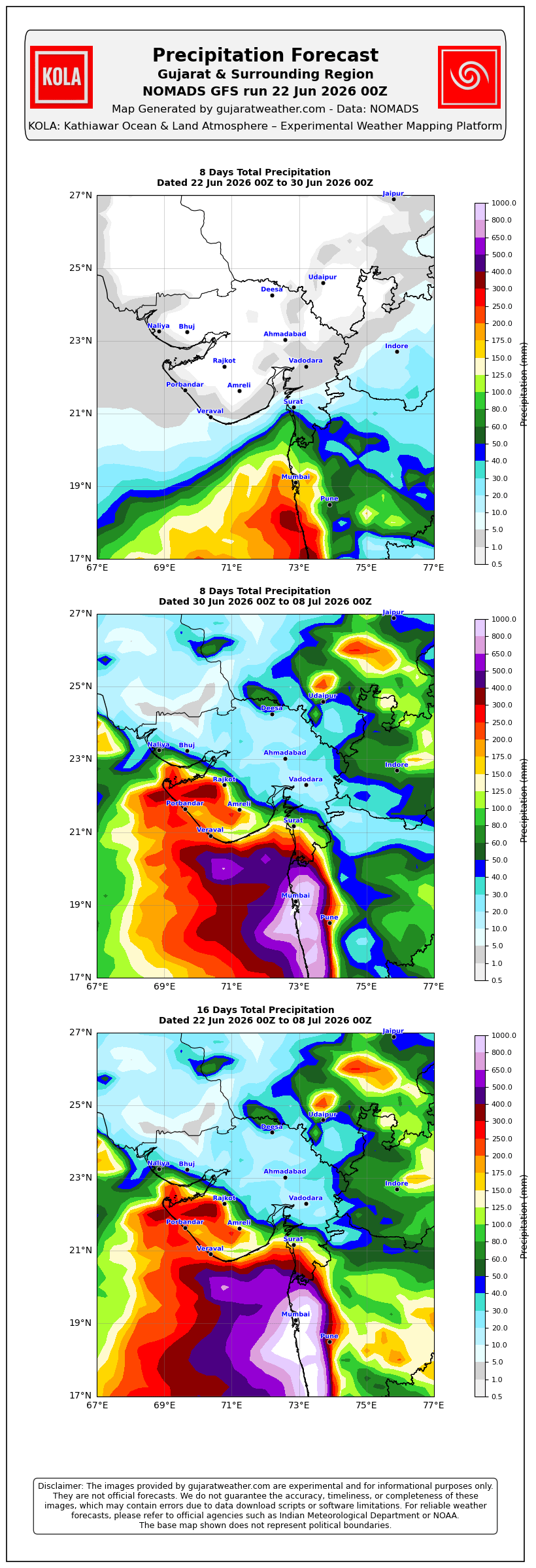
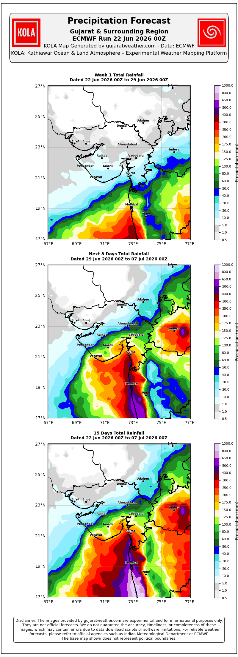
Pre-Monsoon Activity To Continue Over Saurashtra, Gujarat & Kutch During 22nd–28th June 2026
Advance of Southwest Monsoon 2026
Some conditions as per the IMD Bulletin:
The Southwest Monsoon has further advanced into some more parts of central Arabian Sea, Maharashtra, Telangana, remaining parts of Karnataka, some parts of Chhattisgarh, some more parts of Odisha, Jharkhand & Bihar, today the 22nd June, 2026.
The Northern Limit of Monsoon passes through 19°N/60°E, 19°N/65°E, 18.8°N/70°E, Alibag, Pune, Nizamabad, Dantewada, Balangir, Sundargarh, Chatra, Gaya, Muzaffarpur and 28.3°N/83°E as on 22nd June, 2026.
Conditions are favorable for further advance of southwest monsoon into remaining parts of central Arabian Sea, some more parts of Maharashtra including Mumbai, remaining parts of Telangana and Odisha, some more parts of Chhattisgarh, Jharkhand and Bihar during next 48 hours.
The trough from north Gujarat to West Central Arabian Sea across Saurashtra at 3.1 km above mean sea level persists.
Weather Forecast For Saurashtra, Gujarat & Kutch (22nd–28th June 2026)
Pre-Monsoon Activity
Isolated pre-monsoon activity is expected to continue during the forecast period.
Isolated means rainfall activity over 1% to 25% of the area.
Winds
Predominantly Southwesterly winds are expected during the forecast period.
Wind speeds are expected to vary between 15 km/h and 40 km/h, with occasional changes in wind direction, especially during pre-monsoon activity.
Advance Indications:
During the week following the forecast period, the chances for advance of the Southwest Monsoon over parts of Gujarat State appear favorable.
Please refer to the maps given below for the supporting indications.
સૌરાષ્ટ્ર, ગુજરાત અને કચ્છમાં 22 થી 28 જૂન 2026 દરમિયાન પ્રી-મોન્સૂન પ્રવૃત્તિ ચાલુ રહેવાની શક્યતા
દક્ષિણ-પશ્ચિમ ચોમાસું 2026 ની આગેકૂચ
IMD બુલેટિન મુજબ કેટલીક પરિસ્થિતિઓ:
દક્ષિણ-પશ્ચિમ ચોમાસું આજે 22 જૂન 2026ના રોજ મધ્ય અરબી સમુદ્રના વધુ ભાગોમાં, મહારાષ્ટ્ર, તેલંગાણામાં, કર્ણાટકના બાકીના ભાગોમાં, છત્તીસગઢના કેટલાક ભાગોમાં તેમજ ઓડિશા, ઝારખંડ અને બિહારના વધુ કેટલાક ભાગોમાં આગળ વધ્યું છે.
22 જૂન 2026ના રોજ ચોમાસાની ઉત્તર સીમા (Northern Limit of Monsoon – NLM) 19°N/60°E, 19°N/65°E, 18.8°N/70°E, અલીબાગ, પુણે, નિઝામાબાદ, દંતેવાડા, બાલાંગીર, સુંદરગઢ, ચાત્રા, ગયા, મુઝફ્ફરપુર અને 28.3°N/83°Eમાંથી પસાર થાય છે.
આગામી 48 કલાક દરમિયાન મધ્ય અરબી સમુદ્રના બાકીના ભાગોમાં, મહારાષ્ટ્રના વધુ ભાગોમાં (મુંબઈ સહિત), તેલંગાણા અને ઓડિશાના બાકીના ભાગોમાં તેમજ છત્તીસગઢ, ઝારખંડ અને બિહારના વધુ કેટલાક ભાગોમાં દક્ષિણ-પશ્ચિમ ચોમાસાની વધુ આગેકૂચ માટે પરિસ્થિતિ અનુકૂળ છે.
ઉત્તર ગુજરાતથી સૌરાષ્ટ્ર થઈ પશ્ચિમ-મધ્ય અરબી સમુદ્ર સુધીનો ટ્રફ સરેરાશ સમુદ્ર સપાટીથી 3.1 કિ.મી. ઊંચાઈએ યથાવત્ છે.
સૌરાષ્ટ્ર, ગુજરાત અને કચ્છ માટે હવામાન આગાહી (22 થી 28 જૂન 2026)
પ્રી-મોન્સૂન પ્રવૃત્તિ
આગાહી સમયગાળા દરમિયાન આઇસોલેટેડ પ્રી-મોન્સૂન વરસાદી પ્રવૃત્તિ ચાલુ રહેવાની શક્યતા છે.
આઇસોલેટેડ (Isolated) નો અર્થ વિસ્તારના 1% થી 25% ભાગમાં વરસાદી પ્રવૃત્તિ થવાની શક્યતા.
પવનો
આગાહી સમયગાળા દરમિયાન મુખ્યત્વે દક્ષિણ-પશ્ચિમ દિશાના પવનો ફૂંકાવાની શક્યતા છે.
પવનની ઝડપ સામાન્ય રીતે 15 કિ.મી./કલાકથી 40 કિ.મી./કલાક વચ્ચે રહેવાની શક્યતા છે. પ્રી-મોન્સૂન પ્રવૃત્તિ દરમિયાન પવનની દિશામાં પણ ક્યારેક ફેરફાર થઈ શકે છે.
આગળના સંકેતો
આગાહી સમયગાળા પછીના અઠવાડિયામાં ગુજરાત રાજ્યના કેટલાક ભાગોમાં દક્ષિણ-પશ્ચિમ ચોમાસાની એન્ટ્રી માટેની શક્યતા અનુકૂળ જણાય છે.
આ અંગેના આધારરૂપ સંકેતો માટે ઉપર દર્શાવેલ વરસાદ ના નકશા આપેલ છે.
Caution: Please refer/rely on IMD/RSMC Bulletins/Advisories for Storms & Weather related matter.
સાવચેતી: સ્ટોર્મ કે હવામાન અંગે ની માહિતી માટે ભારતીય હવામાન ખાતા/ગવર્મેન્ટ ના બુલેટીન/સુચના પર નિર્ભર રહેવું.
Read Comment Policy – કમેન્ટ માટે માર્ગદર્શન વાંચો
How To Upload Profile Picture For WordPress – વર્ડપ્રેસ માં પ્રોફાઈલ પિક્ચર કેમ રાખવું
Forecast In Akila Daily Dated 22nd June 2026
Forecast In Sanj Samachar Daily Dated 22nd June 2026
મુકો હવે લાપસી ના આંધરણ.
Vah sir
Good news sir
Vah re vah
sir KOLA IMD GSF kem positive nathi
Te 10 nu chhe
Bija 15 and 16 divas na chhe
તારીખ: 22 જૂન 2026 ભારતીય હવામાન વિભાગ (IMD) મુજબ મીડ-ડે બુલેટિન નૈઋત્યનું ચોમાસું આજે વધુ આગળ વધીને મધ્ય અરબી સમુદ્રના કેટલાક વધુ ભાગો, મહારાષ્ટ્ર, તેલંગાણા, કર્ણાટકના બાકીના ભાગો તેમજ છત્તીસગઢ, ઓડિશા, ઝારખંડ અને બિહારના કેટલાક વધુ વિસ્તારોમાં પ્રવેશ્યું છે. હાલ ચોમાસાની ઉત્તર સીમા (NLM) 19°N/60°E, 19°N/65°E, 18.8°N/70°E, અલીબાગ, પુણે, નિઝામાબાદ, દંતેવાડા, બલાંગીર, સુંદરગઢ, ચાત્રા, ગયા, મુઝફ્ફરપુર અને 28.3°N/83°E પરથી પસાર થાય છે. આગામી 48 કલાક દરમિયાન ચોમાસું મધ્ય અરબી સમુદ્રના બાકી ભાગો, મહારાષ્ટ્રના વધુ વિસ્તારો (મુંબઈ સહિત), તેલંગાણા અને ઓડિશાના બાકી ભાગો તેમજ છત્તીસગઢ, ઝારખંડ અને બિહારના વધુ વિસ્તારોમાં આગળ વધવા માટે પરિસ્થિતિ અનુકૂળ છે. ➤ સરેરાશ સમુદ્ર સપાટી પર… Read more »
In Bhavnagar rain started today at 2.50pm
ગુડ ન્યૂઝ સર જી
Good news
Good news
Thanks for new update.sir..
& kola joya pachi aem thayu ke have meghraja padhramani karse….?