Monsoon Expected To Progress Over Gujarat Region & Enter Saurashtra & Kutch Zone During Forecast Period 1st-8th July 2026
Advance of Southwest Monsoon 2026
Some conditions as per the IMD Bulletin:
- The Northern Limit of Monsoon (NLM) continues to pass through 20°N/60°E, 20°N/65°E, 20°N/70°E, Surat, Indore, Mandla, Daltonganj, Motihari and 28.3°N/83°E.
- Conditions are favorable for the further advance of the Southwest Monsoon into some more parts of the North Arabian Sea, Gujarat, Madhya Pradesh, remaining parts of Chhattisgarh, Jharkhand & Bihar, and parts of Uttar Pradesh & Uttarakhand during the next two days, and thereafter into some more parts of Madhya Pradesh, Uttar Pradesh, Uttarakhand, parts of Himachal Pradesh, Jammu & Kashmir, Ladakh, southeast Rajasthan and the remaining parts of Gujarat during the subsequent 2–3 days.
- The seasonal trough at mean sea level from Punjab to Bihar across Haryana and Uttar Pradesh persists.
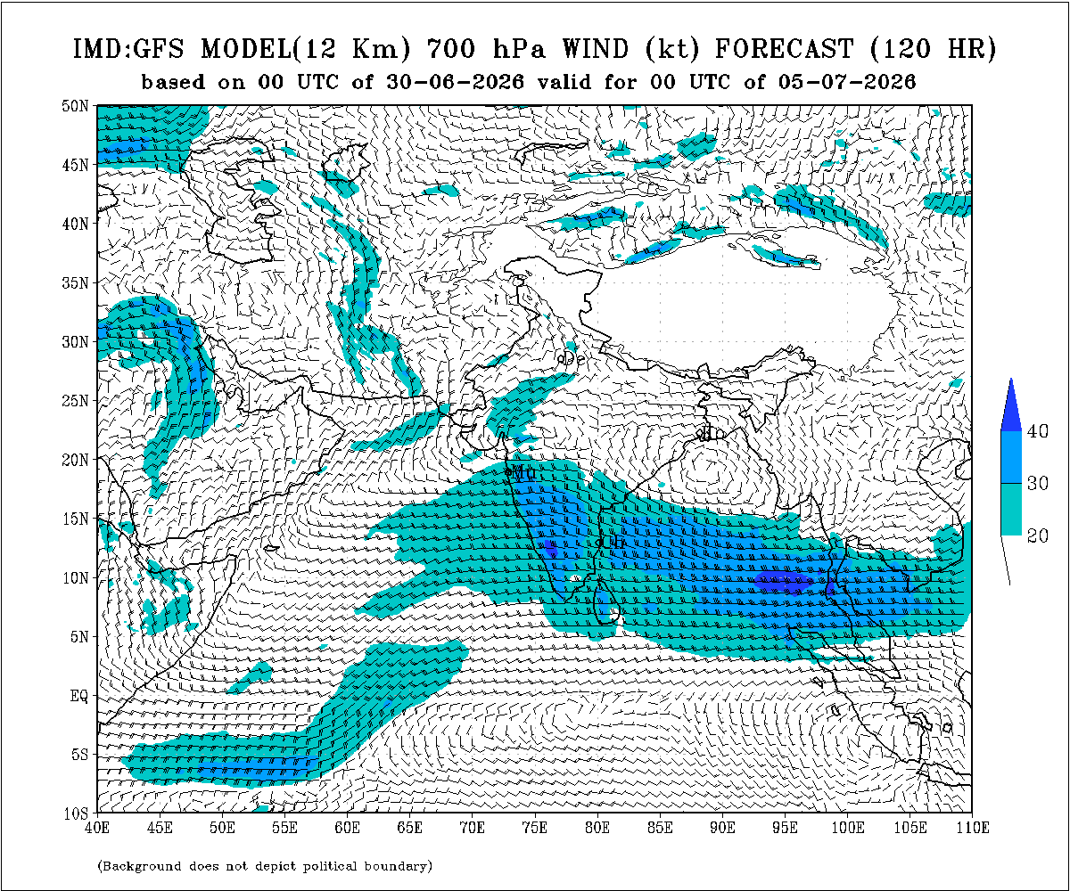
- The trough extending from north-central Madhya Pradesh to the East-Central Arabian Sea across north Maharashtra persists and is now seen between 4.5 km and 5.8 km above mean sea level.
- An upper air cyclonic circulation (UAC) lies over north Odisha and neighborhood at 5.8 km above mean sea level.
- Another upper air cyclonic circulation lies over the north Bay of Bengal adjoining south Bangladesh between 1.5 km and 5.8 km above mean sea level.
- An upper air cyclonic circulation lies over Saurashtra at 3.1 km above mean sea level.
Expected Parameters:
Multiple Upper Air Cyclonic Circulations (UACs) are expected to develop, and at times may combine into a broader circulation. An east-west shear zone extending from Gujarat to West Bengal across Central India is also expected to develop. The distribution and intensity of rainfall will depend on the day-to-day evolution of these weather systems.
Weather Forecast for Saurashtra, Gujarat & Kutch (1st–8th July 2026)
Gujarat Region:
- Scattered to fairly widespread light to moderate rainfall on many days.
- Heavy to very heavy rainfall is likely on a few days.
- Thunderstorms, lightning and gusty winds of 40–50 kmph are likely at times.
Expected Total Rainfall Distribution
- 10% of the area: Up to 25 mm
- 30% of the area: 25–75 mm
- 60% of the area: 75–150 mm, with isolated places exceeding 250 mm
Saurashtra & Kutch
- Scattered light to moderate rainfall during the period.
- Isolated heavy to very heavy rainfall is likely on a day or two
- Thunderstorms, lightning and gusty winds of 40–50 kmph are likely at times.
Expected Total Rainfall Distribution:
- 25% of the area: Up to 25 mm
- 50% of the area: 25–75 mm
- 25% of the area: Above 75 mm, with some centers exceeding 150 mm
Summary:
- The Southwest Monsoon is expected to make further progress across Gujarat Region and advance into Saurashtra & Kutch during the forecast period.
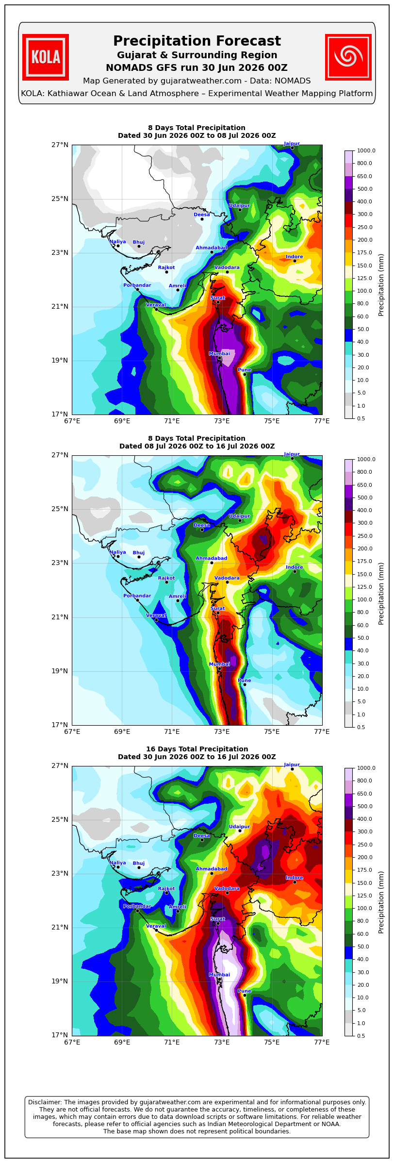
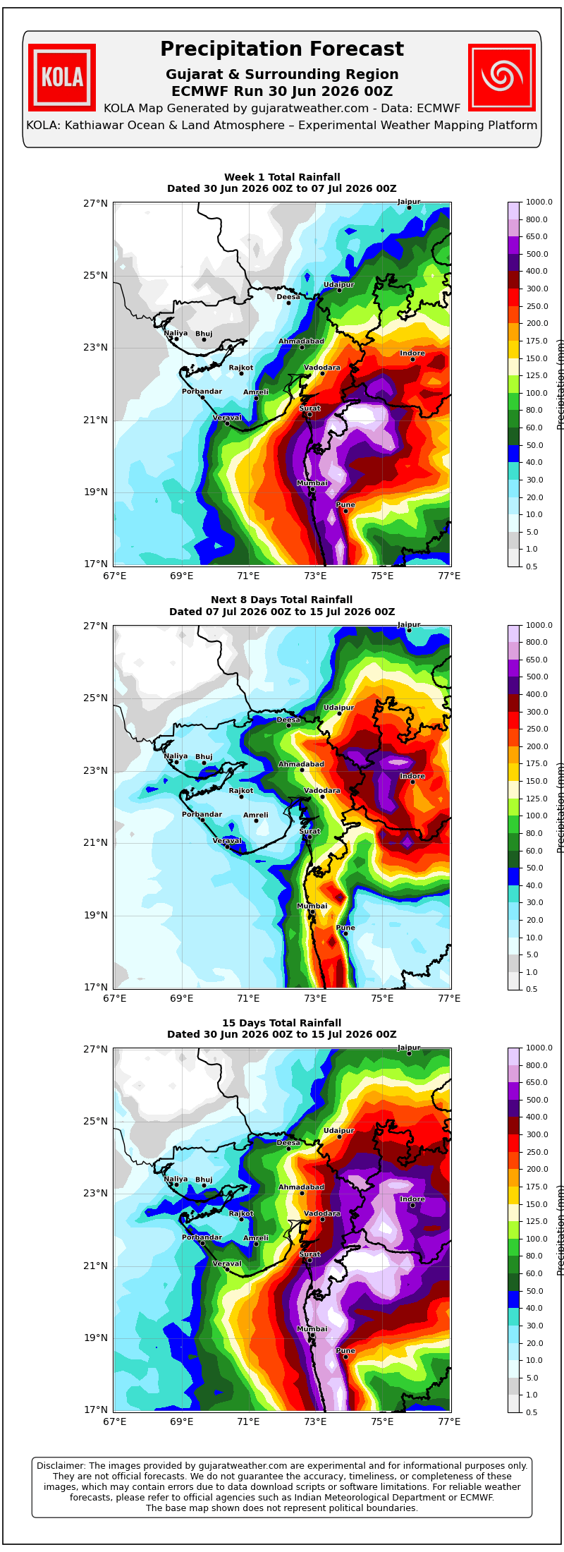
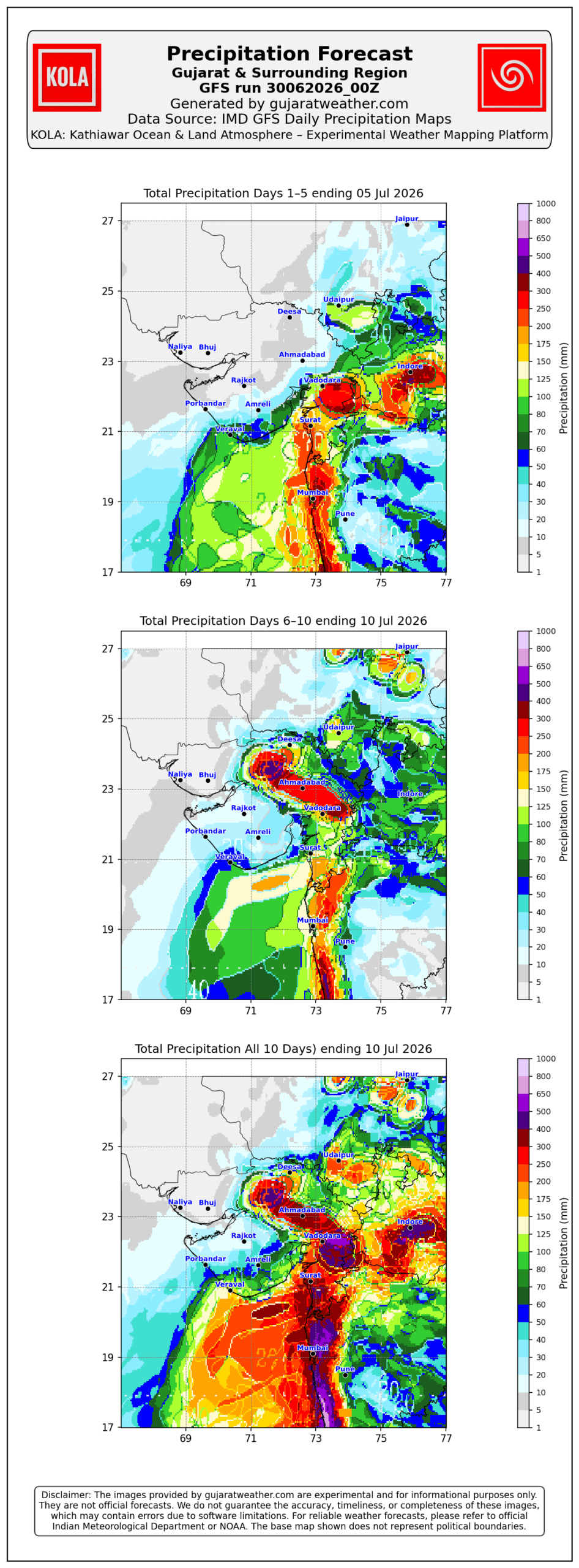
- Rainfall coverage and overall rainfall amounts are expected to increase across the entire State from 3rd July onward and will be significantly higher over Gujarat Region than over Saurashtra & Kutch.
Please refer to the maps given below for the supporting indications.
1 થી 8 જુલાઈ 2026 દરમિયાન ચોમાસું ગુજરાત રિજિયનમાં આગળ વધવાની તથા સૌરાષ્ટ્ર-કચ્છ ઝોનમાં પ્રવેશવાની શક્યતા
દક્ષિણપશ્ચિમ ચોમાસું 2026ની પ્રગતિ
IMD બુલેટિન મુજબ કેટલીક મુખ્ય પરિસ્થિતિઓ:
❖ ચોમાસાની ઉત્તર સીમા (Northern Limit of Monsoon – NLM) હાલ 20°N/60°E, 20°N/65°E, 20°N/70°E, સુરત, ઇન્દોર, મંડલા, ડાલ્ટનગંજ, મોતિહારી અને 28.3°N/83°E પરથી પસાર થાય છે.
❖ આગામી 2 દિવસ દરમિયાન દક્ષિણપશ્ચિમ ચોમાસું ઉત્તર અરબી સમુદ્રના વધુ ભાગો, ગુજરાત, મધ્ય પ્રદેશ, છત્તીસગઢના બાકીના ભાગો, ઝારખંડ, બિહાર તથા ઉત્તર પ્રદેશ અને ઉત્તરાખંડના કેટલાક ભાગોમાં આગળ વધવા માટે પરિસ્થિતિ અનુકૂળ છે. ત્યારબાદના 2–3 દિવસ દરમિયાન મધ્ય પ્રદેશ, ઉત્તર પ્રદેશ, ઉત્તરાખંડના વધુ ભાગો, હિમાચલ પ્રદેશ, જમ્મુ-કાશ્મીર, લદ્દાખ, દક્ષિણ-પૂર્વ રાજસ્થાન તથા ગુજરાતના બાકીના ભાગોમાં આગળ વધવાની શક્યતા છે.
❖ સમુદ્ર સપાટીએ પંજાબથી હરિયાણા અને ઉત્તર પ્રદેશ થઈ બિહાર સુધી વિસ્તરેલી મોસમી ટ્રફ યથાવત છે.
❖ ઉત્તર-મધ્ય મધ્ય પ્રદેશથી ઉત્તર મહારાષ્ટ્ર થઈ પૂર્વ-મધ્ય અરબી સમુદ્ર સુધી વિસ્તરેલી ટ્રફ યથાવત છે અને હાલમાં તે સરેરાશ સમુદ્ર સપાટીથી **4.5 થી 5.8 કિ.મી.**ની ઊંચાઈએ જોવા મળે છે.
❖ ઉત્તર ઓડિશા અને આસપાસના વિસ્તારમાં સરેરાશ સમુદ્ર સપાટીથી **5.8 કિ.મી.**ની ઊંચાઈએ અપર એર સાયક્લોનિક સર્ક્યુલેશન (UAC) આવેલું છે.
❖ દક્ષિણ બાંગ્લાદેશને અડીને આવેલા ઉત્તર બંગાળની ખાડી પર **1.5 થી 5.8 કિ.મી.**ની ઊંચાઈ વચ્ચે અન્ય એક અપર એર સાયક્લોનિક સર્ક્યુલેશન (UAC) આવેલું છે.
❖ સૌરાષ્ટ્ર ઉપર સરેરાશ સમુદ્ર સપાટીથી **3.1 કિ.મી.**ની ઊંચાઈએ અપર એર સાયક્લોનિક સર્ક્યુલેશન (UAC) આવેલું છે.
અપેક્ષિત પરિબળો:
એકથી વધુ અપર એર સાયક્લોનિક સર્ક્યુલેશન (UAC) વિકસે તેવી શક્યતા છે અને અમુક સમયે તે મળીને વિશાળ સર્ક્યુલેશનનું સ્વરૂપ ધારણ કરી શકે છે. ઉપરાંત મધ્ય ભારત પરથી પસાર થતો ગુજરાતથી પશ્ચિમ બંગાળ સુધીનો પૂર્વ-પશ્ચિમ શિયર ઝોન પણ વિકસે તેવી શક્યતા છે. વરસાદનું વિતરણ અને તેની તીવ્રતા આ હવામાન પરિબળોમાં દરરોજ થતા ફેરફારો પર આધારિત રહેશે.
સૌરાષ્ટ્ર, ગુજરાત અને કચ્છ માટે હવામાન આગાહી (1થી 8 જુલાઈ 2026)
ગુજરાત રિજિયન
- ઘણા દિવસો સુધી છૂટાછવાયા થી ઘણા વિસ્તારોમાં હળવાથી મધ્યમ વરસાદની શક્યતા.
- એકાદ-બે દિવસ ભારેથી અતિ ભારે વરસાદની શક્યતા.
- અમુક સમયે ગાજવીજ, વીજળી તથા 40–50 કિમી/કલાકની ઝડપે પવન ફૂંકાવાની શક્યતા.
અંદાજિત કુલ વરસાદનું વિતરણ:
- 10% વિસ્તાર: 25 મિ.મી. સુધી
- 30% વિસ્તાર: 25 થી 75 મિ.મી.
- 60% વિસ્તાર: 75 થી 150 મિ.મી., જ્યારે છૂટાછવાયા સ્થળોએ 250 મિ.મી.થી વધુ વરસાદ પડી શકે છે.
સૌરાષ્ટ્ર અને કચ્છ
- સમગ્ર સમયગાળા દરમિયાન છૂટાછવાયો હળવાથી મધ્યમ વરસાદની શક્યતા.
- એકાદ-બે દિવસે છૂટાછવાયા સ્થળોએ ભારેથી અતિ ભારે વરસાદની શક્યતા.
- અમુક સમયે ગાજવીજ, વીજળી તથા 40–50 કિમી/કલાકની ઝડપે પવન ફૂંકાવાની શક્યતા.
અંદાજિત કુલ વરસાદનું વિતરણ:
- 25% વિસ્તાર: 25 મિ.મી. સુધી
- 50% વિસ્તાર: 25 થી 75 મિ.મી.
- 25% વિસ્તાર: 75 મિ.મી.થી વધુ, જ્યારે કેટલાક કેન્દ્રોમાં 150 મિ.મી.થી વધુ વરસાદ પડી શકે છે.
સારાંશ:
- આગાહી સમયગાળા દરમિયાન દક્ષિણપશ્ચિમ ચોમાસું ગુજરાત રિજિયનમાં વધુ આગળ વધે તથા સૌરાષ્ટ્ર-કચ્છ ઝોનમાં પ્રગતિ કરશે.
- 3 જુલાઈથી સમગ્ર રાજ્યમાં વરસાદનું આવરણ તથા વરસાદની કુલ માત્રામાં વધારો થવાની શક્યતા છે, જોકે ગુજરાત રિજિયનમાં વરસાદનું આવરણ અને કુલ વરસાદ સૌરાષ્ટ્ર-કચ્છની સરખામણીએ નોંધપાત્ર રીતે વધુ રહેવાની સંભાવના છે.
આ અંગેના આધારરૂપ સંકેતો માટે ઉપર દર્શાવેલ વરસાદ ના નકશા આપેલ છે.
Caution: Please refer/rely on IMD/RSMC Bulletins/Advisories for Storms & Weather related matter.
સાવચેતી: સ્ટોર્મ કે હવામાન અંગે ની માહિતી માટે ભારતીય હવામાન ખાતા/ગવર્મેન્ટ ના બુલેટીન/સુચના પર નિર્ભર રહેવું.
Read Comment Policy – કમેન્ટ માટે માર્ગદર્શન વાંચો
How To Upload Profile Picture For WordPress – વર્ડપ્રેસ માં પ્રોફાઈલ પિક્ચર કેમ રાખવું
Forecast In Akila Daily Dated 30th June 2026

Forecast In Sanj Samachar Daily Dated 30th June 2026
સર કાલાવડ થી રાજકોટ સુધી વરસાદ સાવ નથી.
મોટાવડાલા, નિકાવા આસપાસ ઘણા ગામ બાકી છે.
વાવણી જેવો વરસાદ થાય એવુ ખરું.
કોમેન્ટ કરજો પ્લીઝ
Vagar varsade monsoon progress
Wah hawana khatu wah
Dwarka thi morbi sudhi kiyau varsad che nai aa baju dariya pati ma
????????
કેશોદ તથા આસપાસના વિસ્તારોમાં સતત બીજા દિવસે જળબંબાકાર જેવી સ્થિતિ આજે બપોર પછી થી સતત જોરદાર વરસાદ ચાલુ છે
30 minit thya heavy rain chalu che…
Sir…aje amare..11 thi 11.30…pachhi…1 thi 2…saro varsad
ધોરાજીમાં ધોધમાર વરસાદ
Gajvij pavan jode zhaptu pasty Dholka ma
તારીખ 3 જુલાઈ 2026 આજની પરિસ્થિતિ ભારતીય હવામાન વિભાગ અનુસાર મીડ ડે બુલેટિન ❖ દક્ષિણ-પશ્ચિમ ચોમાસું આજે 03 જુલાઈ, 2026 ના રોજ ઉત્તર અરબી સમુદ્રના વધુ કેટલાક ભાગોમાં, ગુજરાતમાં, મધ્ય પ્રદેશના બાકીના ભાગોમાં તેમજ રાજસ્થાન અને હરિયાણાના વધુ કેટલાક ભાગોમાં આગળ વધ્યું છે. ❖ ચોમાસાની ઉત્તર સીમા (NLM) 22°N/60°E, 22°N/65°E, Jamnagar (જામનગર), Udaipur (ઉદયપુર), Ajmer (અજમેર), Jhunjhunu (ઝુંઝુનુ), Hisar (હિસાર), Bathinda (ભટિંડા) અને 32.5°N/70°E પરથી પસાર થાય છે. ❖ આગામી 4-5 દિવસ દરમિયાન દક્ષિણ-પશ્ચિમ ચોમાસું ઉત્તર અરબી સમુદ્રના વધુ કેટલાક ભાગોમાં, ગુજરાતમાં, હરિયાણા અને પંજાબના બાકીના ભાગોમાં તથા રાજસ્થાનના વધુ કેટલાક વિસ્તારોમાં આગળ વધવા માટે પરિસ્થિતિ અનુકૂળ છે. ❖ ઉત્તર-પશ્ચિમ… Read more »
Valido aa vakhte Dwarka varao thi chheto chheto rahe chhe
25% of the area some centers exceeding 150 mm. Aa padav ame par gaya chi.
Aasha rakhi kudrat het varshavanu chalu rakhe.
સર અમારે કેશોદમાં કાલ સાંજ સુધીનો ૧૬ અને આજનો ૮-10 ઇંચ ની આજુબાજુ વરસાદ થાય જશે મને લાગેછે આ બધો વરસાદ ૫૦૦hpa ના લીધે આવ્યો હોય હું ૩ દિવસ થયા ફૂલ મોનીટરીંગ કરું છું તો સાચું કે નય
Icon and ECMWF banne model ma ghano difference chhe varsad mate, to aapnu su manavu chhe sir ?
Difference chhe
Anu karan su se
Sir Neknam,rohisala,mitana aaj kal ma thase avu kai varsad ni sakyata
Sar bngadani khadima sistam bnva purve andaj kem marvo ke sistam 1. 2. Divs ma banse ane aapne labh aape te disama aagd vdh6?
10 divas na map aapel chhe IMD ma
Icon saurashtra mate sara varsad ma Adikham che ane Haal shear zone 21 N pr continue che.
Porbandar ma aje tadko vadda mix vatavarn che aje savar thi zaptao bandh che.
અશોકભાઈ જસદણ તાલુકાના ઘણા ગામો માં વાવણીલાયક વરસાદ નથી વરસાદ થાય એવા સાન્સ ખરા જવાબ આપવા વિનંતી
Varsad ma vara farti varo hoy.
IMD ….. વગર વરસાદે ચોમાસું બેસી ગયું.આવું થોડું હોય ……
Sar mukhya raund aajno divas ke pasi aagad salu rese ? Amesav baki6
Mukhya round 8 tarikh sudhi
Jsk Mitro gai kale jamavat karavi ane aaje vatavaran saru pan ek chato nathi!!!!!
સર તમે કયો એટલે પાકુ પણ icon શિવાય એક પણ મોડલ ધ્રોલ બાજુ વરસાદ બતાવ તુ નથી
Tankara baju vrshad nathi toh asha Rakhi sakai
Chomasu haju bethu
જયશ્રી કૃષ્ણ સુપેડી મા ગાજવીજ સાથે જોરદાર વરસાદ પડે છે
સિસ્ટમ ક્યાં મોડલ મુજબ ચાલે સે કઈ સમજણ પડતી નથી કોઈ પરકાશ પાડો
Kai System?
Abdha ke e Bangal ni khadi ma sistam banese e
Bengal ni khadi ma Low Pressure chhe…te ghanu dooor chhe.
Ahi Ghana centero ma full Varsad chhe. Aapadi najik je System maate Samaiu karva ni raah na jovay.
Ahi je Mehmano aavya chhe teni aagtaa swaagata karo.
Te Bhai nu khevu em chhe ke vadra no dayro kai baju bhego thase eni jankari kaya modal pase chhe
Varsad joiye ke Vadada ?
Gadhiya vadada nathi jota. hoyto ek karidibang vadri dejo. sir devbhumi dwarka jilane have duskal no dar lagi thyo chhe .
Aje Amare 11:30 to 12:30 andaje 2 inch
Sir unjha ( N.G.) mo kyare varshad avshe javab apsoji
Jamnagar and Udaipur ni line doro etle tamo najik chho Unjha
Khabar na padi sir
Chomasu rekha tamari najik chhe.
Sir amare atyare ati bhare varshad chalu se
સર
જામનગર જિલ્લા ના ધ્રોલ તાલુકાના
ગામો માં ક્યારે વરસાદ થશે
બિજા ગામો માં ધોધમાર વરસાદ નું સાંભળી ને મન
પાછું પડે કે કાયક અમો રહી નો જાય
Sir have amare varsad kedi bandh thashe?
Jay Shree Radhe Krishna Ji
સર અમારે પાલીતાણા બાજુ હવે વાદળ કયારે આવસે આજે પણ નથી દેખાતા
Sir Pratikbhai busy chhe ke…? bulletin ni rah ma chhie…!
Pratikbhai shu karey ? IMD update karey pachhi ahi aavey.
મીડ ડે બુલેટિન હવામાન વિભાગ બપોરે એક વાગ્યા પછી મુકે ક્યારેક બે પણ વાગી જાય છે
સર જય માતાજી ધ્રોલ અને આજુ બાજુ વિસ્તારમાં ચોમાસું પોચી ગયું કહેવાય કે હજી વાર છે
Tamarey Varsad thay tyare pahonchyu kahevay. Pachhi Jamnagar Jodiya vigere ma Varsad thay toe pan pahonchi gayu samjo.
Pochase avu lage chhe saheb a round ma
Ha CHomasu pahonchi gayu aaje.
Dwarka, Jamnagar and Udaipur
Sir chomasu jovani link apo ne
Chomasu Rekha jovo
Ama to Morbi pan avi gyu ae pan vagar varsad ma??
ખૂબ આભાર સાહેબ તમારી અપડેટ અને ભગવાન પાસે અમારી માંગણી કરતા ડબલ વરસાદ પડ્યો છે. આગલા બે દિવસમાં. અને આજે બપોરના ૧૧ વાગ્યે ફરી ચાલુ થઈ ગયો છે.
વરસાદ કેટલોક ભાગ માં આવે icon modal અડીખમછે
10:15 વાગ્યાથી ધમાકેદાર ધોધમાર વરસાદ ચાલુ છે
Sutrapada 137+314= 451 mm. Hju salu,
sir surendranagar ma varsad avi javana koi chans khara agahi samay ma
Surendranagar ma BONUS round aavel.
Chomasu haju sharu thay chhe….uchak jeen na rakhay !
Saheb, freere meteo bandha se saku hoi to chaalu karo
Freemeteo chalu j chhe. Teni par maro koi control nathi !
403 forbidden aavu lakhelu aave se
Teni sathe maarey kai leva deva nathi.
maarey freemeteo barobar chaley chhe.
To saheb aamaru kaik karo ne tena vina nakamu, soda leman karvanu
માળિયા હાટીનામાં સવારથી જ પવન સાથે વરસાદ ચાલુ છે…
Ashokbhai Surat ma wednesday ratna sada 3 vagyathi 5 vagya sudhi bhare varsad hato pan tena aankda na to paper ma avya k na to news ma atyare bhare varsad ni agahi vacche zarmar varsad padi rahyo che.
Tarikh 3rd etle ke gai kaale aakho divas ahi 24 hour Rainfall Data uplabddh hata jema Palsana 203 mm and Bardoli 197, Mahuva (Surat) 191 mm.
Surat City ma 24 mm hato.
Aa varsad 3 tarikh savar na 6.00 vagya sudhi na 24 kalak ma hato.
Ahi Gujarat Government ni SEOC ni Mahiti uplabddh chhe.
Saib kutiyana ma saro padi gyo kal.
સમગ્ર કેશોદ માણાવદર માંગરોળ માળીયા વિસ્તારો માં 16 ઇંચ જેટલો ભારે વરસાદ નોંધાયો છે
જય મુરલીધર સાહેબ
તમે ગીરનાર ની ગોદમાં વરસાદ ની મોજ માણી લીધી
હવે અમારા એરિયા ના ખેડૂતો ને અહક થાય છે વરસાદ વગર ખરેખર પણ આ વાલીડો હેત વરસાવતો નથી
જુન કોરો ગયા પછી જુલાઈ નો એક એક દિવસ વહમો લાગે છે હો સાહેબ
જય શ્રી ક્રિષ્ના સર આજ અમારો વારો આવશે કે નઈ અહીંયા વાવણી કેડી થશે?
Guruji
તા 2/7/26
ઢસા વિસ્તાર
ઢસા જં ઢસાગામ આંબરડી પાટણા ધોધાસમડી માલપરા માંડવા ઉમરડા જલાલપુર કાચરડી મેમદા નવાગામ ભંડારીયા જાળીયા ચાવંડ સિતાપર ગામમાં ધોધમાર વરસાદ અંદાજે 1.00 ઇંચ થી 3 ઇંચ થી વધુ હશે
વાવણી લાયક વરસાદ ખેતરુ બારા પાણી નીકળ્યા નદી તળાવ મા નવા નીર ની આવક થય
આભાર ગુરુજી
Sir. Me ghani var evu notice karyu chhe ke vijdi thay tyare light pan jatka mare tenu su karan hoi sake. Plz. Ans.
Kyarek Vijadi Electric pole marfat jamin sudhi aavi hoy tyare aavu thai shakey.
Aa system Jo mp upper Avi ne west avse to vadhare phaydo thaws per recent ecm end mp thi north Lao jay che je
Sir chomasu jamnagar ariyama kyare agal vadhse
Sir badh leval uper bhej purto che to varsad varshva ma shu taklif pade che
અમે પણ હજી વાવણી લાયક વરસાદ ની રાહ માં……2 દિવસ થી વાતાવરણ બને પણ કોઈક કોઈક છાંટા જ આવે છે
અમારે સાંજના આકડા પ્રમાણે જામજોધપુર અને આજુબાજુ ના ગામડામાં ૬ થી ૭ ઇંચ જેવો વરસાદ પડ્યો