Monsoon Expected To Progress Over Gujarat Region & Enter Saurashtra & Kutch Zone During Forecast Period 1st-8th July 2026
Advance of Southwest Monsoon 2026
Some conditions as per the IMD Bulletin:
- The Northern Limit of Monsoon (NLM) continues to pass through 20°N/60°E, 20°N/65°E, 20°N/70°E, Surat, Indore, Mandla, Daltonganj, Motihari and 28.3°N/83°E.
- Conditions are favorable for the further advance of the Southwest Monsoon into some more parts of the North Arabian Sea, Gujarat, Madhya Pradesh, remaining parts of Chhattisgarh, Jharkhand & Bihar, and parts of Uttar Pradesh & Uttarakhand during the next two days, and thereafter into some more parts of Madhya Pradesh, Uttar Pradesh, Uttarakhand, parts of Himachal Pradesh, Jammu & Kashmir, Ladakh, southeast Rajasthan and the remaining parts of Gujarat during the subsequent 2–3 days.
- The seasonal trough at mean sea level from Punjab to Bihar across Haryana and Uttar Pradesh persists.
- The trough extending from north-central Madhya Pradesh to the East-Central Arabian Sea across north Maharashtra persists and is now seen between 4.5 km and 5.8 km above mean sea level.
- An upper air cyclonic circulation (UAC) lies over north Odisha and neighborhood at 5.8 km above mean sea level.
- Another upper air cyclonic circulation lies over the north Bay of Bengal adjoining south Bangladesh between 1.5 km and 5.8 km above mean sea level.
- An upper air cyclonic circulation lies over Saurashtra at 3.1 km above mean sea level.
Expected Parameters:
Multiple Upper Air Cyclonic Circulations (UACs) are expected to develop, and at times may combine into a broader circulation. An east-west shear zone extending from Gujarat to West Bengal across Central India is also expected to develop. The distribution and intensity of rainfall will depend on the day-to-day evolution of these weather systems.
Weather Forecast for Saurashtra, Gujarat & Kutch (1st–8th July 2026)
Gujarat Region:
- Scattered to fairly widespread light to moderate rainfall on many days.
- Heavy to very heavy rainfall is likely on a few days.
- Thunderstorms, lightning and gusty winds of 40–50 kmph are likely at times.
Expected Total Rainfall Distribution
- 10% of the area: Up to 25 mm
- 30% of the area: 25–75 mm
- 60% of the area: 75–150 mm, with isolated places exceeding 250 mm
Saurashtra & Kutch
- Scattered light to moderate rainfall during the period.
- Isolated heavy to very heavy rainfall is likely on a day or two
- Thunderstorms, lightning and gusty winds of 40–50 kmph are likely at times.
Expected Total Rainfall Distribution:
- 25% of the area: Up to 25 mm
- 50% of the area: 25–75 mm
- 25% of the area: Above 75 mm, with some centers exceeding 150 mm
Summary:
- The Southwest Monsoon is expected to make further progress across Gujarat Region and advance into Saurashtra & Kutch during the forecast period.
- Rainfall coverage and overall rainfall amounts are expected to increase across the entire State from 3rd July onward and will be significantly higher over Gujarat Region than over Saurashtra & Kutch.
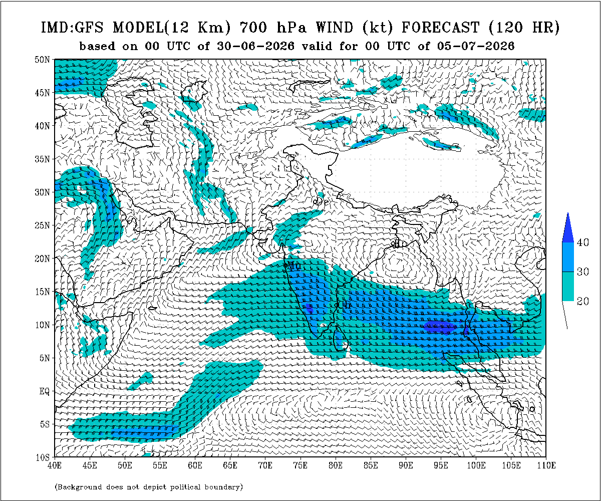
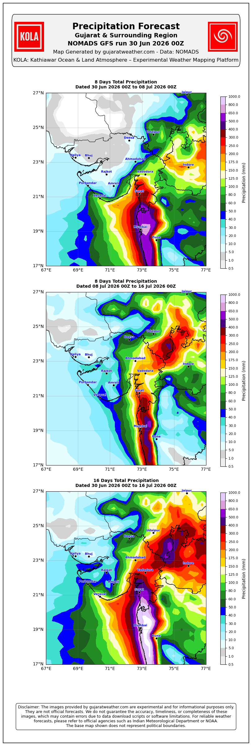
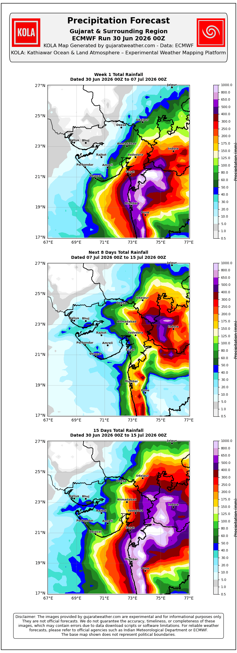
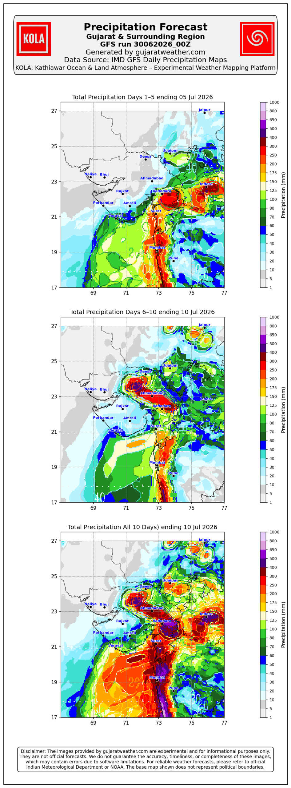
Please refer to the maps given below for the supporting indications.
1 થી 8 જુલાઈ 2026 દરમિયાન ચોમાસું ગુજરાત રિજિયનમાં આગળ વધવાની તથા સૌરાષ્ટ્ર-કચ્છ ઝોનમાં પ્રવેશવાની શક્યતા
દક્ષિણપશ્ચિમ ચોમાસું 2026ની પ્રગતિ
IMD બુલેટિન મુજબ કેટલીક મુખ્ય પરિસ્થિતિઓ:
❖ ચોમાસાની ઉત્તર સીમા (Northern Limit of Monsoon – NLM) હાલ 20°N/60°E, 20°N/65°E, 20°N/70°E, સુરત, ઇન્દોર, મંડલા, ડાલ્ટનગંજ, મોતિહારી અને 28.3°N/83°E પરથી પસાર થાય છે.
❖ આગામી 2 દિવસ દરમિયાન દક્ષિણપશ્ચિમ ચોમાસું ઉત્તર અરબી સમુદ્રના વધુ ભાગો, ગુજરાત, મધ્ય પ્રદેશ, છત્તીસગઢના બાકીના ભાગો, ઝારખંડ, બિહાર તથા ઉત્તર પ્રદેશ અને ઉત્તરાખંડના કેટલાક ભાગોમાં આગળ વધવા માટે પરિસ્થિતિ અનુકૂળ છે. ત્યારબાદના 2–3 દિવસ દરમિયાન મધ્ય પ્રદેશ, ઉત્તર પ્રદેશ, ઉત્તરાખંડના વધુ ભાગો, હિમાચલ પ્રદેશ, જમ્મુ-કાશ્મીર, લદ્દાખ, દક્ષિણ-પૂર્વ રાજસ્થાન તથા ગુજરાતના બાકીના ભાગોમાં આગળ વધવાની શક્યતા છે.
❖ સમુદ્ર સપાટીએ પંજાબથી હરિયાણા અને ઉત્તર પ્રદેશ થઈ બિહાર સુધી વિસ્તરેલી મોસમી ટ્રફ યથાવત છે.
❖ ઉત્તર-મધ્ય મધ્ય પ્રદેશથી ઉત્તર મહારાષ્ટ્ર થઈ પૂર્વ-મધ્ય અરબી સમુદ્ર સુધી વિસ્તરેલી ટ્રફ યથાવત છે અને હાલમાં તે સરેરાશ સમુદ્ર સપાટીથી **4.5 થી 5.8 કિ.મી.**ની ઊંચાઈએ જોવા મળે છે.
❖ ઉત્તર ઓડિશા અને આસપાસના વિસ્તારમાં સરેરાશ સમુદ્ર સપાટીથી **5.8 કિ.મી.**ની ઊંચાઈએ અપર એર સાયક્લોનિક સર્ક્યુલેશન (UAC) આવેલું છે.
❖ દક્ષિણ બાંગ્લાદેશને અડીને આવેલા ઉત્તર બંગાળની ખાડી પર **1.5 થી 5.8 કિ.મી.**ની ઊંચાઈ વચ્ચે અન્ય એક અપર એર સાયક્લોનિક સર્ક્યુલેશન (UAC) આવેલું છે.
❖ સૌરાષ્ટ્ર ઉપર સરેરાશ સમુદ્ર સપાટીથી **3.1 કિ.મી.**ની ઊંચાઈએ અપર એર સાયક્લોનિક સર્ક્યુલેશન (UAC) આવેલું છે.
અપેક્ષિત પરિબળો:
એકથી વધુ અપર એર સાયક્લોનિક સર્ક્યુલેશન (UAC) વિકસે તેવી શક્યતા છે અને અમુક સમયે તે મળીને વિશાળ સર્ક્યુલેશનનું સ્વરૂપ ધારણ કરી શકે છે. ઉપરાંત મધ્ય ભારત પરથી પસાર થતો ગુજરાતથી પશ્ચિમ બંગાળ સુધીનો પૂર્વ-પશ્ચિમ શિયર ઝોન પણ વિકસે તેવી શક્યતા છે. વરસાદનું વિતરણ અને તેની તીવ્રતા આ હવામાન પરિબળોમાં દરરોજ થતા ફેરફારો પર આધારિત રહેશે.
સૌરાષ્ટ્ર, ગુજરાત અને કચ્છ માટે હવામાન આગાહી (1થી 8 જુલાઈ 2026)
ગુજરાત રિજિયન
- ઘણા દિવસો સુધી છૂટાછવાયા થી ઘણા વિસ્તારોમાં હળવાથી મધ્યમ વરસાદની શક્યતા.
- એકાદ-બે દિવસ ભારેથી અતિ ભારે વરસાદની શક્યતા.
- અમુક સમયે ગાજવીજ, વીજળી તથા 40–50 કિમી/કલાકની ઝડપે પવન ફૂંકાવાની શક્યતા.
અંદાજિત કુલ વરસાદનું વિતરણ:
- 10% વિસ્તાર: 25 મિ.મી. સુધી
- 30% વિસ્તાર: 25 થી 75 મિ.મી.
- 60% વિસ્તાર: 75 થી 150 મિ.મી., જ્યારે છૂટાછવાયા સ્થળોએ 250 મિ.મી.થી વધુ વરસાદ પડી શકે છે.
સૌરાષ્ટ્ર અને કચ્છ
- સમગ્ર સમયગાળા દરમિયાન છૂટાછવાયો હળવાથી મધ્યમ વરસાદની શક્યતા.
- એકાદ-બે દિવસે છૂટાછવાયા સ્થળોએ ભારેથી અતિ ભારે વરસાદની શક્યતા.
- અમુક સમયે ગાજવીજ, વીજળી તથા 40–50 કિમી/કલાકની ઝડપે પવન ફૂંકાવાની શક્યતા.
અંદાજિત કુલ વરસાદનું વિતરણ:
- 25% વિસ્તાર: 25 મિ.મી. સુધી
- 50% વિસ્તાર: 25 થી 75 મિ.મી.
- 25% વિસ્તાર: 75 મિ.મી.થી વધુ, જ્યારે કેટલાક કેન્દ્રોમાં 150 મિ.મી.થી વધુ વરસાદ પડી શકે છે.
સારાંશ:
- આગાહી સમયગાળા દરમિયાન દક્ષિણપશ્ચિમ ચોમાસું ગુજરાત રિજિયનમાં વધુ આગળ વધે તથા સૌરાષ્ટ્ર-કચ્છ ઝોનમાં પ્રગતિ કરશે.
- 3 જુલાઈથી સમગ્ર રાજ્યમાં વરસાદનું આવરણ તથા વરસાદની કુલ માત્રામાં વધારો થવાની શક્યતા છે, જોકે ગુજરાત રિજિયનમાં વરસાદનું આવરણ અને કુલ વરસાદ સૌરાષ્ટ્ર-કચ્છની સરખામણીએ નોંધપાત્ર રીતે વધુ રહેવાની સંભાવના છે.
આ અંગેના આધારરૂપ સંકેતો માટે ઉપર દર્શાવેલ વરસાદ ના નકશા આપેલ છે.
Caution: Please refer/rely on IMD/RSMC Bulletins/Advisories for Storms & Weather related matter.
સાવચેતી: સ્ટોર્મ કે હવામાન અંગે ની માહિતી માટે ભારતીય હવામાન ખાતા/ગવર્મેન્ટ ના બુલેટીન/સુચના પર નિર્ભર રહેવું.
Read Comment Policy – કમેન્ટ માટે માર્ગદર્શન વાંચો
How To Upload Profile Picture For WordPress – વર્ડપ્રેસ માં પ્રોફાઈલ પિક્ચર કેમ રાખવું
Forecast In Akila Daily Dated 30th June 2026

Forecast In Sanj Samachar Daily Dated 30th June 2026
Amare kalno 3 inch ajano 2 inch varasad
સર અમારે હવે ક્યારે ટેંકર ઠલવાસે હવે વાટ જોઈને થાકી ગયા
Sarji amare haju 1 chanto pan padiyo nathi bapu amari daxin said porbandar Ane purv baju bhanvad sudhi varsad pugi gayo . Have apni agahi na divso ma amare vavni layak varsad avi sake ? Sarji ecm. To have saurast ma kalno divas j varsad batave amari said ,have avi Jay to saru. Bapu haju asha rakhi sakay ne?
No apde ky bhag ma ave avu se ny khoti asa rakhvi ny 9 thi 16 joye su thy e
આઈકોન ની અત્યાર ની અપડેટ જોરદાર જ છે.. જોરદાર ૧૦-૧૦ ઈંચ વરસાદ આવી જશે.. તારીખ ૪-૫-૬ માં.. આનો સ્ક્રીન શોટ પાડી લે જો..
KOLA special update ICON ni karel chhe
Special icon update kariyu che to sir tamne pan hal icon satiay ni najik lage che…?
ICON ni bol baala chhe etle
Wah …. Milanbhai, Full Confidence, kevu pade ho…..
Aje lagbhag akha upleta taluka ma vavni thay gay che…
Sir amare botad na ugamedi ma 4 ich
Sir junagadh. Ane girsomnath ma aje varsad padyo te kay paribad ne karne padyo che
East West shear zone 21N par chhe
Gadu talala Tulsi shyam upar
એ સ્થળો ના નામ મે મારી રીતે 21°N પર કે તેની આસપાસના છે જે મિત્રો ને સમજવામાં સરળતા રહે તે માટે ભારતીય હવામાન વિભાગ તેમના બુલેટિન માં શીયરઝોન માં કોઈ સ્થળો નો ઉલ્લેખ કરેલો નથી
Jsk સર… ઇનો લાભ ક્રમશ ઉત્તર તરફ મળી શકે ખરો?
Have dwarka varav no varo aave aevu lage che night / early morning & yesterday day .☔
Sir amare Jasdan na Lilapur ma haji chata pan nathi to avavani shakyata se
Sir Keshod Ma Megh Tandav kal thi ajana Sanj na 8 vagya sudhi no 404 mm kul varsad thai gayo chhe.. Have bhandh thay to saru bhagwan… Sir amara vistar ma atla varsad no tamne andaj hato?ke pachhi paribalo change thaya chhe.Jay Shree Radhe Krishna Ji…
Bas મેહુલીયા વરસીયા ભલા હૉ
It’s true?
Ahi ni update ma lakhel vaat lakhel chhe.
સર, અમારે જામટીબડી મા ( ભાયાવદર પાસે ) ખુબ સારો વરસાદ તમામ નાના મોટા ચેકડેમ ઓવરફ્લો, નદી પણ આવી તા – 1/7/26 ના 2.5 ઇંચ અને 2/7/26 ના 4.5 ઇંચએમ બે દિવસ નો કુલ 7 ઇંચ વરસાદ
મોરબી 2mm, માળિયા 9mm
સવાર ના 8 થી સાંજ ના 8 સુધી
Ahmedabad , Satellite area , Madhayam sari gati a varsad ni sharuat thai , Pavan bilkul nathi..
Amarey Vadiye Varsad saro thai gayo.
240 Kilo. Daana kora ma 30 Tarikhey vavya hata. Baaki Orvel hatu.
Dungadi Vavavani baaki.
સર તમે આત્મ નિર્ભર છો. તમને પૂરો વિશ્વાસ હતો વરસાદ થશે. અમે તૈયાર ભજીયા વાળા છીએ. એટલે અમારે ઘાણવો તૈયાર નથી થયો. કોરા મા વાવણી સારી બે દિવસ વેલુ ઉગે.
ડુંગળી ક્યારે વાવવી છે સર અને કયું બિયારણ વાવવું સે
Havey nakki thashe.
Wah, Saheb …. khoob sara samachar,
Jay mataji sir…mare pan tamara jevu j 6e kapas 4 divas pela kora ma chopi ne mukyo 6e aek khetar ma Ane bija aek khetar ma 5 divas pela ugadi ne taiyar kryo 6e baki amara vistar ma kheduto ne 8 pan(piyat) thai gya hve aavi jay to saru…baki aaje pan sanje 5 vagya thi 7 vagya sudhi gajvij ane pavan funkayo pan aek santo na aavyo varsad no….
જૂનાગઢ અને ગીર સોમનાથમાં ક્યારેય દુષ્કાળની સ્થિતિ સર્જાઈ શકે જ નહીં — પછી ભલે ‘એલ નીનો’ હોય કે નહીં
અમારે કેશોદ આજે 11 ઇંચ જેટલો વરસાદ છે
શર અમારો વારો આવશે કે શું અમારે હજી સુધી એક છાંટો વરસાદ નથી પડી યો
chomamasu aagad vadhshe etle varo aavi jashe.
Tamaro abhar sar
Sir dhrol taluka ma varsad nathi to aa round varo aavse ke Kem gya varas ma amara vistar ma bov j ochho varsad hato akha vars ma khetar mathi pani bar nota nikadya ane haji varsad ma varo nathi aavyo etale badha khedut mitro ne andar thi dar Lage chhe sir please javab aapjo
Namaste sar amare aje
2 pm thi 5 pm jor dar varsad
Padiyo 8.5 ich varsad che
Ashok sir.katla mm a 1 inch thay.
25 mm aashare
સૌરાષ્ટ્રમાં હમારે માળીયા હાટીનામા 12થી14 ઇંચ સુધી વરસાદ પડ્યો તમને આટલો અંદાજ હતો. ને હજી આટલો થયશકે આ રાઉન્ડ માં?
Kalavad taluka na nulila gam ma adjit.4inch jevo varsad 12thi2sudhi
જય માતાજી
અશોકભાઈ
અમારે પવન ફૂંકાઈ રહ્યો છે
Sir અમારે ધ્રાંગધ્રા તાલુકા મા 4તારીખ પસી વધૂ ચાન્સ ગણાય ને વરસાદ માટે
Update vancho
સર જે ભગવાન સુપેડી મા ગઈકાલે તથા આજે 2 દિવસ નો કુલ 4 ઈચ વરસાદ ખુબ સરસ વાવણી થઈ ગઈ
Vavni layk varsad
Rajkot ma 1.22 inch ,! Hase atlo badho sir ?
સર આજે અમારે ભુકા બોલાવ્યા વરસાદે ૩ કલાક સતત ધોધમાર પડ્યો અમારી વેણુ નદીમાં પુર આવ્યું હું શેઠ વડાળા કામ ઉપર હતો ત્યાથી અમારા ગીગણી સુધી ધોમધોકાર વરસાદ પડ્યો ૩ થી ૪ ઇંચ સુધી નો આકડો હોઈ શકે
Sir rajkot vada ne gya varas ni jem akash ma jovanu rese evu lagi rahyu 6
Sir…aje meghraja e super alnino no bakvas karanara na dhajagara udavya…!
Sir Keshod, Mangrol Ane Maliya Hatina ma news vara no super al nino futyo bhayankar megh tandav keshod ma kal thi ajna bapor na 4 vagya sudhima 281mm varsad khabakyo.. Have jene joto hoy te bhale lai jay.. Jay Radhe Mohan
Sir,tmari aa update pehle agad ni update ma me comment Kari hati te mare joyti hoy to madi shake ..?
Atyare na med padey.
Nirante vaat.
Sir, Aaje Chomasani Pankh Saurashtra Baju aagal vadhi nathi pn gujarat baju aagal vadhi 6. evu 6???
Yes.
કુતિયાણામાં 2 કલાકમાં 4 થી 6 વાગ્યા સુધીમાં ધોધમાર 101 MM વરસાદ(4 ઇંચ) …સવારથી સાંજના 6 વાગ્યા સુધીમાં દિવસ દરમિયાન 131 MM વરસાદ નોંધાયો
shihor taluka ma kai nathi.
Imd e kalak pela you tube ma video upload karyo ema 2 3 4 tarikh ma saurashtra Gujarat ma isolated ma red warning ⚠️ aapi didhu hve warning ma kono varo aave jamnagar hji koru chhe full taiyari chhe pan varsasto nathi
Sarapdad paddhari kedi varo avse
માળિયા હાટીના અવિરત અનરાધાર..લાગે છે જૂન ની ખોટ પુરી થઈ ગઇ છે…
વિજાપુર મા ધીમી ધારે વરસાદ ચાલુ 5:20 મિનિટ
અશોકભાઈ નમસ્તે ! જય શ્રીકૃષ્ણ જય ઉમિયાજી
અમારે વડાળી માં ગઈ કાલ અને આજનો લગભગ જોરદાર છ ઈંચ થી વધારે વરસાદ છે. વાવણી જોરદાર….
સર અમારે તો ICON મોડેલ મુજબ વાદળ વરસે તો જ વરસાદ ભાગમાં આવે એવું હતું.આજે એ મુજબ હાલયુ હોય એવું લાગે છે.બપોર થી અત્યાર સુધીમાં એટલે કે 5 વાગ્યા સુધીમાં 4 થી 5 ઈસ જેવો વરસાદ પડ્યો છે.હજુ ચાલુ પણ છે.અમોને આ બધા મોડેલ જોતા આટલી આશા નહોતી.પક્ષિમ સૌરાષ્ટ્ર વિસ્તારમાં.પણ ઘણો વરસાદ પડ્યો.આજે એક વાત સાબિત થઈ કે ecmwf.gfs.imd.બીજા ઘણા બધા મોડેલો હોય પણ ભગવાન થી આગળ કોઈ નહિ.
Kal thi haji varsad vadhse k Saurasta ma?…
ગામ માં બે સામાન્ય રેડા અને વાડીએ છાંટો પણ નથી બપોર ના ૧૨:૩૦ થી ગાજવીજ ચાલુ છે .
સર અમારે 4 પી. એમ. થી 1 કલાક થી વરસાદ ચાલુ છે હજુ પણ વરસાદ ચાલુ જ છે 25 મિલ પડી ગયો ખેતરમાં પાણી ભરાઈ ગયા જય શ્રી કૃષ્ણ
sir Bob માં આજે low બતાવે છે સાચું low છે કે 997 માં થી પાછું 1001 માં આવી જાય એવું છે
BOB ma jovani jarur nathi.
Ghar aangane je aavya hoy tene Aawkaar devay !
Sir mota vadala nikava aaspaas varsad nathi
Varsad aave avi sakyata khari
Sir amare tatha aaspas ma khub Saro varsad chalu che 12pm thi.andajit…..6+ hase……Ane atyare pan chalu j che Lage che k aaje Amaro moj dem bhari dese….
sir vav tharad bhaju kevi sakyta che
Geberal Varsad Dakshin thi Uttar baju pragati karey chhe. Time thay etle varo aavi jaay.
સર અમારી બાજુ વાવણી કરાય તેવી વરાપ કયારે થાસે ? કારણ કે આ વર્ષે મગફળી નુ વાવેતર ઘણુ મોળુ (લેટ) થઈ ગયુ છે.
અરણી માં 100 mm થી વધુ વરસાદ આજનો
Chotila ane bajuna gam ma vavani layak saro varsad padi gayo
Porbandar City ma savar thi bapor sudhi ma 2 jordar zapta 10 thi 15 min na padya pan rainfall data 0 mm Dar varsh ni jem Varsad na data update j nathi krtu Porbandar.
હારીજ વરસાદ ક્યારે આવશે?