Monsoon Expected To Progress Over Gujarat Region & Enter Saurashtra & Kutch Zone During Forecast Period 1st-8th July 2026
Advance of Southwest Monsoon 2026
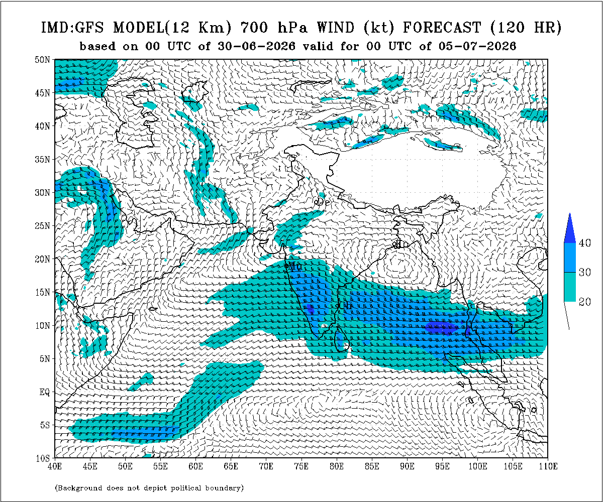
Some conditions as per the IMD Bulletin:
- The Northern Limit of Monsoon (NLM) continues to pass through 20°N/60°E, 20°N/65°E, 20°N/70°E, Surat, Indore, Mandla, Daltonganj, Motihari and 28.3°N/83°E.
- Conditions are favorable for the further advance of the Southwest Monsoon into some more parts of the North Arabian Sea, Gujarat, Madhya Pradesh, remaining parts of Chhattisgarh, Jharkhand & Bihar, and parts of Uttar Pradesh & Uttarakhand during the next two days, and thereafter into some more parts of Madhya Pradesh, Uttar Pradesh, Uttarakhand, parts of Himachal Pradesh, Jammu & Kashmir, Ladakh, southeast Rajasthan and the remaining parts of Gujarat during the subsequent 2–3 days.
- The seasonal trough at mean sea level from Punjab to Bihar across Haryana and Uttar Pradesh persists.
- The trough extending from north-central Madhya Pradesh to the East-Central Arabian Sea across north Maharashtra persists and is now seen between 4.5 km and 5.8 km above mean sea level.
- An upper air cyclonic circulation (UAC) lies over north Odisha and neighborhood at 5.8 km above mean sea level.
- Another upper air cyclonic circulation lies over the north Bay of Bengal adjoining south Bangladesh between 1.5 km and 5.8 km above mean sea level.
- An upper air cyclonic circulation lies over Saurashtra at 3.1 km above mean sea level.
Expected Parameters:
Multiple Upper Air Cyclonic Circulations (UACs) are expected to develop, and at times may combine into a broader circulation. An east-west shear zone extending from Gujarat to West Bengal across Central India is also expected to develop. The distribution and intensity of rainfall will depend on the day-to-day evolution of these weather systems.
Weather Forecast for Saurashtra, Gujarat & Kutch (1st–8th July 2026)
Gujarat Region:
- Scattered to fairly widespread light to moderate rainfall on many days.
- Heavy to very heavy rainfall is likely on a few days.
- Thunderstorms, lightning and gusty winds of 40–50 kmph are likely at times.
Expected Total Rainfall Distribution
- 10% of the area: Up to 25 mm
- 30% of the area: 25–75 mm
- 60% of the area: 75–150 mm, with isolated places exceeding 250 mm
Saurashtra & Kutch
- Scattered light to moderate rainfall during the period.
- Isolated heavy to very heavy rainfall is likely on a day or two
- Thunderstorms, lightning and gusty winds of 40–50 kmph are likely at times.
Expected Total Rainfall Distribution:
- 25% of the area: Up to 25 mm
- 50% of the area: 25–75 mm
- 25% of the area: Above 75 mm, with some centers exceeding 150 mm
Summary:
- The Southwest Monsoon is expected to make further progress across Gujarat Region and advance into Saurashtra & Kutch during the forecast period.
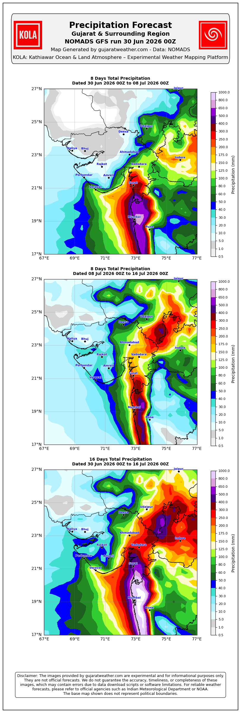
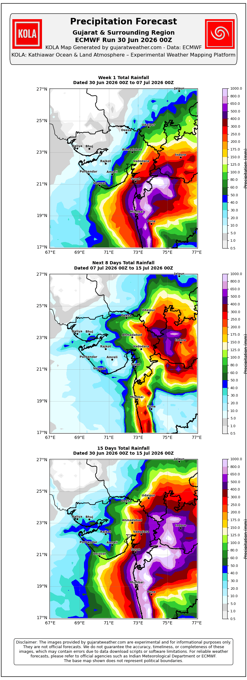
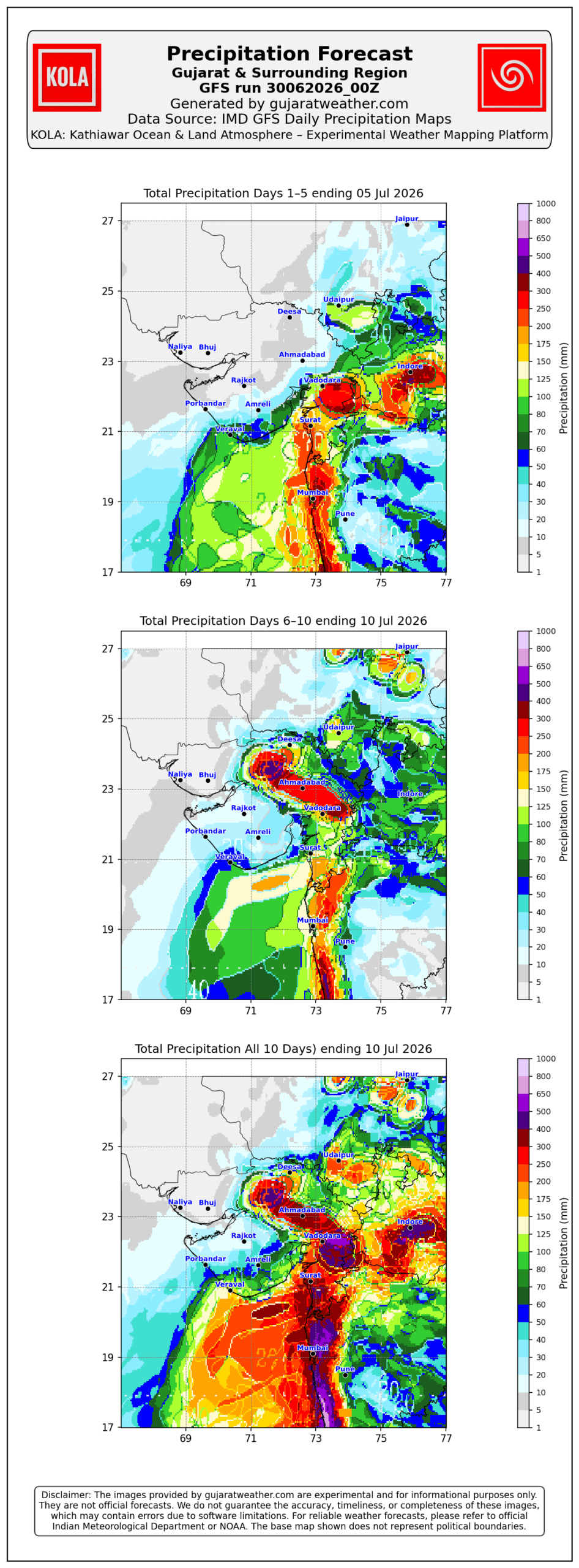
- Rainfall coverage and overall rainfall amounts are expected to increase across the entire State from 3rd July onward and will be significantly higher over Gujarat Region than over Saurashtra & Kutch.
Please refer to the maps given below for the supporting indications.
1 થી 8 જુલાઈ 2026 દરમિયાન ચોમાસું ગુજરાત રિજિયનમાં આગળ વધવાની તથા સૌરાષ્ટ્ર-કચ્છ ઝોનમાં પ્રવેશવાની શક્યતા
દક્ષિણપશ્ચિમ ચોમાસું 2026ની પ્રગતિ
IMD બુલેટિન મુજબ કેટલીક મુખ્ય પરિસ્થિતિઓ:
❖ ચોમાસાની ઉત્તર સીમા (Northern Limit of Monsoon – NLM) હાલ 20°N/60°E, 20°N/65°E, 20°N/70°E, સુરત, ઇન્દોર, મંડલા, ડાલ્ટનગંજ, મોતિહારી અને 28.3°N/83°E પરથી પસાર થાય છે.
❖ આગામી 2 દિવસ દરમિયાન દક્ષિણપશ્ચિમ ચોમાસું ઉત્તર અરબી સમુદ્રના વધુ ભાગો, ગુજરાત, મધ્ય પ્રદેશ, છત્તીસગઢના બાકીના ભાગો, ઝારખંડ, બિહાર તથા ઉત્તર પ્રદેશ અને ઉત્તરાખંડના કેટલાક ભાગોમાં આગળ વધવા માટે પરિસ્થિતિ અનુકૂળ છે. ત્યારબાદના 2–3 દિવસ દરમિયાન મધ્ય પ્રદેશ, ઉત્તર પ્રદેશ, ઉત્તરાખંડના વધુ ભાગો, હિમાચલ પ્રદેશ, જમ્મુ-કાશ્મીર, લદ્દાખ, દક્ષિણ-પૂર્વ રાજસ્થાન તથા ગુજરાતના બાકીના ભાગોમાં આગળ વધવાની શક્યતા છે.
❖ સમુદ્ર સપાટીએ પંજાબથી હરિયાણા અને ઉત્તર પ્રદેશ થઈ બિહાર સુધી વિસ્તરેલી મોસમી ટ્રફ યથાવત છે.
❖ ઉત્તર-મધ્ય મધ્ય પ્રદેશથી ઉત્તર મહારાષ્ટ્ર થઈ પૂર્વ-મધ્ય અરબી સમુદ્ર સુધી વિસ્તરેલી ટ્રફ યથાવત છે અને હાલમાં તે સરેરાશ સમુદ્ર સપાટીથી **4.5 થી 5.8 કિ.મી.**ની ઊંચાઈએ જોવા મળે છે.
❖ ઉત્તર ઓડિશા અને આસપાસના વિસ્તારમાં સરેરાશ સમુદ્ર સપાટીથી **5.8 કિ.મી.**ની ઊંચાઈએ અપર એર સાયક્લોનિક સર્ક્યુલેશન (UAC) આવેલું છે.
❖ દક્ષિણ બાંગ્લાદેશને અડીને આવેલા ઉત્તર બંગાળની ખાડી પર **1.5 થી 5.8 કિ.મી.**ની ઊંચાઈ વચ્ચે અન્ય એક અપર એર સાયક્લોનિક સર્ક્યુલેશન (UAC) આવેલું છે.
❖ સૌરાષ્ટ્ર ઉપર સરેરાશ સમુદ્ર સપાટીથી **3.1 કિ.મી.**ની ઊંચાઈએ અપર એર સાયક્લોનિક સર્ક્યુલેશન (UAC) આવેલું છે.
અપેક્ષિત પરિબળો:
એકથી વધુ અપર એર સાયક્લોનિક સર્ક્યુલેશન (UAC) વિકસે તેવી શક્યતા છે અને અમુક સમયે તે મળીને વિશાળ સર્ક્યુલેશનનું સ્વરૂપ ધારણ કરી શકે છે. ઉપરાંત મધ્ય ભારત પરથી પસાર થતો ગુજરાતથી પશ્ચિમ બંગાળ સુધીનો પૂર્વ-પશ્ચિમ શિયર ઝોન પણ વિકસે તેવી શક્યતા છે. વરસાદનું વિતરણ અને તેની તીવ્રતા આ હવામાન પરિબળોમાં દરરોજ થતા ફેરફારો પર આધારિત રહેશે.
સૌરાષ્ટ્ર, ગુજરાત અને કચ્છ માટે હવામાન આગાહી (1થી 8 જુલાઈ 2026)
ગુજરાત રિજિયન
- ઘણા દિવસો સુધી છૂટાછવાયા થી ઘણા વિસ્તારોમાં હળવાથી મધ્યમ વરસાદની શક્યતા.
- એકાદ-બે દિવસ ભારેથી અતિ ભારે વરસાદની શક્યતા.
- અમુક સમયે ગાજવીજ, વીજળી તથા 40–50 કિમી/કલાકની ઝડપે પવન ફૂંકાવાની શક્યતા.
અંદાજિત કુલ વરસાદનું વિતરણ:
- 10% વિસ્તાર: 25 મિ.મી. સુધી
- 30% વિસ્તાર: 25 થી 75 મિ.મી.
- 60% વિસ્તાર: 75 થી 150 મિ.મી., જ્યારે છૂટાછવાયા સ્થળોએ 250 મિ.મી.થી વધુ વરસાદ પડી શકે છે.
સૌરાષ્ટ્ર અને કચ્છ
- સમગ્ર સમયગાળા દરમિયાન છૂટાછવાયો હળવાથી મધ્યમ વરસાદની શક્યતા.
- એકાદ-બે દિવસે છૂટાછવાયા સ્થળોએ ભારેથી અતિ ભારે વરસાદની શક્યતા.
- અમુક સમયે ગાજવીજ, વીજળી તથા 40–50 કિમી/કલાકની ઝડપે પવન ફૂંકાવાની શક્યતા.
અંદાજિત કુલ વરસાદનું વિતરણ:
- 25% વિસ્તાર: 25 મિ.મી. સુધી
- 50% વિસ્તાર: 25 થી 75 મિ.મી.
- 25% વિસ્તાર: 75 મિ.મી.થી વધુ, જ્યારે કેટલાક કેન્દ્રોમાં 150 મિ.મી.થી વધુ વરસાદ પડી શકે છે.
સારાંશ:
- આગાહી સમયગાળા દરમિયાન દક્ષિણપશ્ચિમ ચોમાસું ગુજરાત રિજિયનમાં વધુ આગળ વધે તથા સૌરાષ્ટ્ર-કચ્છ ઝોનમાં પ્રગતિ કરશે.
- 3 જુલાઈથી સમગ્ર રાજ્યમાં વરસાદનું આવરણ તથા વરસાદની કુલ માત્રામાં વધારો થવાની શક્યતા છે, જોકે ગુજરાત રિજિયનમાં વરસાદનું આવરણ અને કુલ વરસાદ સૌરાષ્ટ્ર-કચ્છની સરખામણીએ નોંધપાત્ર રીતે વધુ રહેવાની સંભાવના છે.
આ અંગેના આધારરૂપ સંકેતો માટે ઉપર દર્શાવેલ વરસાદ ના નકશા આપેલ છે.
Caution: Please refer/rely on IMD/RSMC Bulletins/Advisories for Storms & Weather related matter.
સાવચેતી: સ્ટોર્મ કે હવામાન અંગે ની માહિતી માટે ભારતીય હવામાન ખાતા/ગવર્મેન્ટ ના બુલેટીન/સુચના પર નિર્ભર રહેવું.
Read Comment Policy – કમેન્ટ માટે માર્ગદર્શન વાંચો
How To Upload Profile Picture For WordPress – વર્ડપ્રેસ માં પ્રોફાઈલ પિક્ચર કેમ રાખવું
Forecast In Akila Daily Dated 30th June 2026

Forecast In Sanj Samachar Daily Dated 30th June 2026
Sir જામજોધપુર મા 2 વાગ્યા થી ચાલુ છે અંદાજે 50 mm જેવો
Sir amare kale rat thi khub sharo varshad pade se haju chalu se nadi ma poor avi gayu.
વીજળીના કડાકા ભડાકા સાથે 3:00 વાગ્યાથી ધોધમાર વરસાદ ચાલુ
Good afternoon..sir maru gam rafala ta.ji. rajkot
Khoob saro varsad..baporna 2.40 thi 4.haji chalu che..khetar bara pani kadhi nakhya…your aagahi is perfect..
હાસ !હવે વાવણીલાયક થઈ ગયો
Icon સિવાય આટલો વરસાદ એક પણ મોડેલ બતાવતું નહોતું
બાકી બધા મોડેલ 10 દિવસ નો માત્ર એક થી બે ઇંચ બતાવતાંહતાં
માત્ર icon એક જ મોડેલ કેટલા દિવસો થી ફૂલ વરસાદ માટે અડગ હતું
Icon જિંદાબાદ
સર જય શ્રીકૃષ્ણ જામ જોધપુર મા બીજો રાઉન્ડ ચાલુ વાવણી પાકી…
Aaje amara gam ma jordar varsad vavni layak varsad thi pani pani 2 inch thi vadhare haji chalu che
Chotila ma vaveni layek versad aavi gayao sir
Sir, Inset Satellite images ma khoob j saras aavkardayak ferfar karel chhe, aapni nishtha and mahenat ne salute chhe, Sir,….
ashok sir
rajkot ma kem varshad nhi aavato weather toek dum saras chhe rajkot mate su ghate ??
ધોરાજી માં સારો વરસાદ આવે છે ૨.૩o વાગ્યા thi
Kutiyana ni east aaju baju dhodhmar
Jsk sir, forcast mujab labh madvanu chalu, dil thi aabhar. Aasha rakhi aagahi samay gada ma avirat labh aapiya rakhe mehulo.
Jsk Varsad Premi Mitro chomasu varsh 2026-27 na. aaje moj padi gai…….
સાબરકાંઠા જિલ્લાના પોલોફોરેસ્ટ ગામમાં હજુ સુધી કોરું જ છે તો ક્યારે આવશે વરસાદ
રબારીકા મોટાવડીયા તા જામજોધપુર મા ધોધમાર 2કલાકથી ફુલ વાવણી
Icon pramane sistam chale chhe varsad jota haji 2 k 3 di hali gyu to El nino goito nay jade
સર અમારે બાબરાના જામ બરવાળા ગામમાં વાવણીલાયક વરસાદ થઈ ગયો
તારીખ:- 02 જુલાઈ 2026 આજની પરિસ્થિતિ ભારતીય હવામાન વિભાગ અનુસાર મીડ ડે બુલેટિન ❖ દક્ષિણપશ્ચિમ ચોમાસું આજે 02 જુલાઈ 2026ના રોજ ગુજરાતના વધુ કેટલાક ભાગોમાં, ઉત્તર પ્રદેશના બાકીના ભાગોમાં, સમગ્ર દિલ્હી, મધ્ય પ્રદેશના મોટા ભાગોમાં, હરિયાણા અને પંજાબ તેમજ રાજસ્થાનના કેટલાક ભાગોમાં આગળ વધ્યું છે. ❖ ચોમાસાની ઉત્તર સીમા (NLM) હાલ 22°N/60°E, 22°N/65°E, Porbandar (પોરબંદર), Vallabh Vidyanagar (વલ્લભ વિદ્યાનગર), Neemuch (નીમચ), Tonk (ટોંક), Bhiwani (ભિવાની), Bathinda (બઠિંડા) અને 32.5°N/70°E પરથી પસાર થાય છે. ❖ આગામી 2 થી 3 દિવસ દરમિયાન દક્ષિણપશ્ચિમ ચોમાસું ઉત્તર અરબી સમુદ્રના વધુ કેટલાક ભાગોમાં, ગુજરાત, મધ્ય પ્રદેશના બાકીના ભાગોમાં, હરિયાણા, પંજાબ અને રાજસ્થાનના વધુ કેટલાક ભાગોમાં… Read more »
Sidsar ma de dhanadhn 1.30 thi. Mojpadigay
Good afternoon sir..sir paschim saurashtra and tankara morbi side kyre rain ni sari saruaat thase.. please answer apjo
Sanala saro varshad chalu Che 11 vagya no chalu kale no 4 inch
બે દિવસથી સારો વરસાદ
જસદણમાં વરસાદ ચાલુ છે
Jasdan ma saro varshad chhalu
Sir,ICON ane UK Saurashtra/Kutch mate pehle thi positive hata ane haju pan chhe.
Badha modal nu soda lemon karai varasad akey modal mujab no Chale badha modal nu joi e aeni mastima Chale chhe.
Upleta ma bapor na 12:30 thi 1:30 vagya sudhima saro varsad aavi gayo 25 mm jevo hase aashre
ગામ_ઉમરાળા, તા.કાલાવડ, જી. જામનગર
ધોધમાર વરસાદ
A spasht che ke koi weather model proper rain predict nathi kari rahyu
E to evuj hoy bhai. Koi pan weather model khali andaaj matej hoy emathi 50 percent sachu padtu hoy che. Jyare jameen par pani pade tyarej sachu manvanu.
Kalavad temaj aaju baju ma vavani layak varsad shalu she.
ગોંડલ મા ફૂલ વરસાદ
Sir amare kale 4.30vage varsad chalu thayo hato aakhi rat Ane atyare bapore 1.15min e pn chalu j se,vache kyarek thodi var band rey total 5inch jetlo thay gyo
Sir…40 minutes thi saro varsad padi rahyo chhe…!
ગોંડલ મા છેલ્લી 10 મિનિટ થી સારો વરસાદ ચાલુ છે.
Sir keshod ma gai kal savar na 10 vagya thi aj na 10 vagya sudhi ma 177 mm varsad khabakyo have amare khamma kare ane jya nathi tya thay to saru Jay Shree Radhe Krishna Ji…
સર અમારે પાલીતાણા તાલુકો સાવ કોરો ધાકોડ સે આશા રાખીયે મેળ પડી જાય
10 vagya zordar zhapta thi sharuat
dholka ma 2 July ae
vadhare ave tevi aasha
Vavani layak varsad thai gyo, sir tamare tyabhi vavani thai javi joi km k amare varsad ae baju thi aavyo to??
Haju khas kai nathi.
Okay, amare aa baju aavi gaj vij sathe intensity maa vadharo thayo to
sar morbi ma to tadko che kyare avsr
મેહુલિયો 2 કલાક થી અનરાધાર ચાલુ ખેતરૂ બાર પાણી નિકળી ગયા અંદાજે 2ઇંચ જેવો
સર અમારે ચોવીસ કલાક માં 150 mm વરસાદ પડી ગયો.હજુય રેડે રેડે ચાલુ જ છે
Imd wrf saru batave che 3 divas & te satiy ni khub najik rahe che … dwarka thi veraval dariya pati ma batave che joye have kevuk rahe che… ☔
Sir, Atyare Rajkot ma Ddhimo Dhimo varsad pade 6.. aa Varsad GFS & ACC model mujab atyare to batave 6.
કેશોદ માં કાલ બપોરે ૧૨ વાગ્યા થી આજ બપોર ના ૧૨ વાગ્યા સુધી અંદાજે ૭ ઇંચ જેટલો વરસાદ પડયો.
Morbiમાં આજથી ધાબળછાયું વાતાવરણ છે.
માળિયા હાટીનામાં અનરાધાર વરસાદ કાલથી અવિરત ધોધમાર ચાલુ … સ્થાનિક નદીઓ માં પુર
Sir icon model kaya desh nu model che
Halma atayrni position pramane bhare varsad gujrat par batave che.avavata divsoma
The ICON modelling framework is a joint project between the German Weather Service and the Max Planck Institute for Meteorology for developing a unified next-generation global numerical weather.
Mtlb German nu che ne..?
Yes.
ICON mujab haale toe aakha Varash na Varsad maate med padi jaay Athvadiya ma !
Sir icon 50 tak sachu padtu hoy che ke kem avreg biju sir kiyarey sistam icon prmane chayli che jnavjo ne sir
Sir e ritnu hale em ta nathi lagtu sir
Bhagvan karene jo halijay to bov saru kevay
ICON મોડલ તો તો ગુજરાત માટે IDEAL સાબિત થાય….હાલ માં FIFA football tournament માં નાની ટીમ મોટી ટીમ ને ભારી પડી છે…નજરઅંદાજ ન કરી શકાય.
Jay mataji sir to pachi icon model par chlavani sakyata khari …?
Chaley Toe El Nino ni ‘MAA’ mari jaay !
દસ વાગ્યે એક રેડો આવીયો વાતાવરણમાં પલટો આવ્યો છે
Gamnu nam aakhu lakho
Tamari agahi mujab Keshod taluka na badha gamda ma saro varsad che Thanks Ashok bhai patel
Vavni layak varsad thay gayo
Kharchiya vankna