Monsoon Expected To Progress Over Gujarat Region & Enter Saurashtra & Kutch Zone During Forecast Period 1st-8th July 2026
Advance of Southwest Monsoon 2026
Some conditions as per the IMD Bulletin:
- The Northern Limit of Monsoon (NLM) continues to pass through 20°N/60°E, 20°N/65°E, 20°N/70°E, Surat, Indore, Mandla, Daltonganj, Motihari and 28.3°N/83°E.
- Conditions are favorable for the further advance of the Southwest Monsoon into some more parts of the North Arabian Sea, Gujarat, Madhya Pradesh, remaining parts of Chhattisgarh, Jharkhand & Bihar, and parts of Uttar Pradesh & Uttarakhand during the next two days, and thereafter into some more parts of Madhya Pradesh, Uttar Pradesh, Uttarakhand, parts of Himachal Pradesh, Jammu & Kashmir, Ladakh, southeast Rajasthan and the remaining parts of Gujarat during the subsequent 2–3 days.
- The seasonal trough at mean sea level from Punjab to Bihar across Haryana and Uttar Pradesh persists.
- The trough extending from north-central Madhya Pradesh to the East-Central Arabian Sea across north Maharashtra persists and is now seen between 4.5 km and 5.8 km above mean sea level.
- An upper air cyclonic circulation (UAC) lies over north Odisha and neighborhood at 5.8 km above mean sea level.
- Another upper air cyclonic circulation lies over the north Bay of Bengal adjoining south Bangladesh between 1.5 km and 5.8 km above mean sea level.
- An upper air cyclonic circulation lies over Saurashtra at 3.1 km above mean sea level.
Expected Parameters:
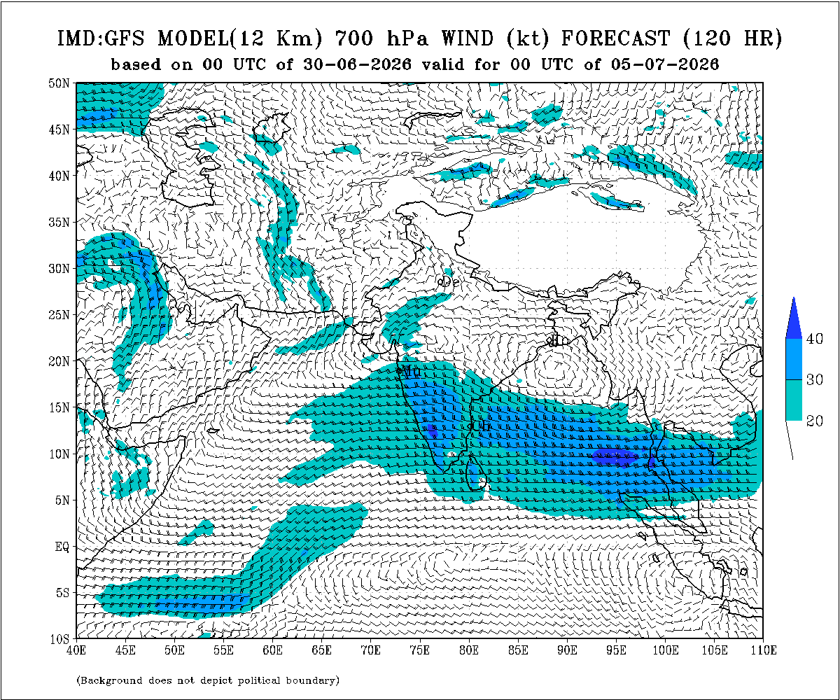
Multiple Upper Air Cyclonic Circulations (UACs) are expected to develop, and at times may combine into a broader circulation. An east-west shear zone extending from Gujarat to West Bengal across Central India is also expected to develop. The distribution and intensity of rainfall will depend on the day-to-day evolution of these weather systems.
Weather Forecast for Saurashtra, Gujarat & Kutch (1st–8th July 2026)
Gujarat Region:
- Scattered to fairly widespread light to moderate rainfall on many days.
- Heavy to very heavy rainfall is likely on a few days.
- Thunderstorms, lightning and gusty winds of 40–50 kmph are likely at times.
Expected Total Rainfall Distribution
- 10% of the area: Up to 25 mm
- 30% of the area: 25–75 mm
- 60% of the area: 75–150 mm, with isolated places exceeding 250 mm
Saurashtra & Kutch
- Scattered light to moderate rainfall during the period.
- Isolated heavy to very heavy rainfall is likely on a day or two
- Thunderstorms, lightning and gusty winds of 40–50 kmph are likely at times.
Expected Total Rainfall Distribution:
- 25% of the area: Up to 25 mm
- 50% of the area: 25–75 mm
- 25% of the area: Above 75 mm, with some centers exceeding 150 mm
Summary:
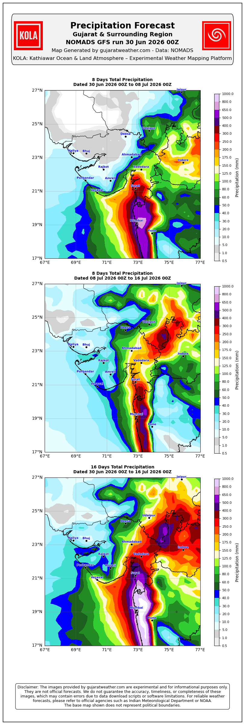
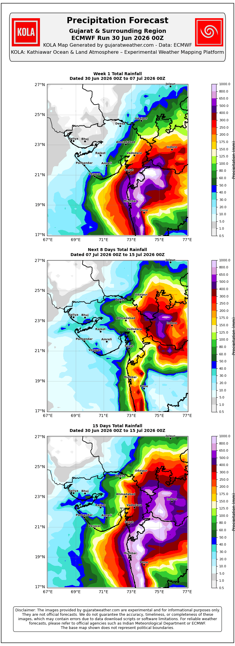
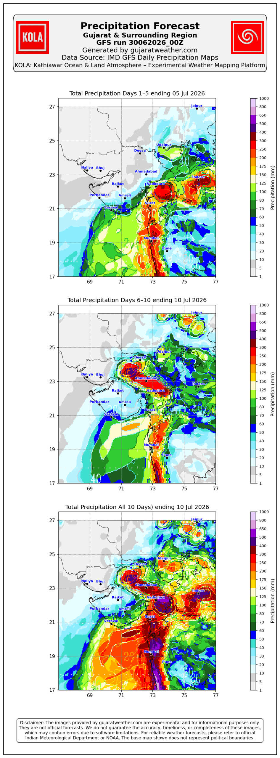
- The Southwest Monsoon is expected to make further progress across Gujarat Region and advance into Saurashtra & Kutch during the forecast period.
- Rainfall coverage and overall rainfall amounts are expected to increase across the entire State from 3rd July onward and will be significantly higher over Gujarat Region than over Saurashtra & Kutch.
Please refer to the maps given below for the supporting indications.
1 થી 8 જુલાઈ 2026 દરમિયાન ચોમાસું ગુજરાત રિજિયનમાં આગળ વધવાની તથા સૌરાષ્ટ્ર-કચ્છ ઝોનમાં પ્રવેશવાની શક્યતા
દક્ષિણપશ્ચિમ ચોમાસું 2026ની પ્રગતિ
IMD બુલેટિન મુજબ કેટલીક મુખ્ય પરિસ્થિતિઓ:
❖ ચોમાસાની ઉત્તર સીમા (Northern Limit of Monsoon – NLM) હાલ 20°N/60°E, 20°N/65°E, 20°N/70°E, સુરત, ઇન્દોર, મંડલા, ડાલ્ટનગંજ, મોતિહારી અને 28.3°N/83°E પરથી પસાર થાય છે.
❖ આગામી 2 દિવસ દરમિયાન દક્ષિણપશ્ચિમ ચોમાસું ઉત્તર અરબી સમુદ્રના વધુ ભાગો, ગુજરાત, મધ્ય પ્રદેશ, છત્તીસગઢના બાકીના ભાગો, ઝારખંડ, બિહાર તથા ઉત્તર પ્રદેશ અને ઉત્તરાખંડના કેટલાક ભાગોમાં આગળ વધવા માટે પરિસ્થિતિ અનુકૂળ છે. ત્યારબાદના 2–3 દિવસ દરમિયાન મધ્ય પ્રદેશ, ઉત્તર પ્રદેશ, ઉત્તરાખંડના વધુ ભાગો, હિમાચલ પ્રદેશ, જમ્મુ-કાશ્મીર, લદ્દાખ, દક્ષિણ-પૂર્વ રાજસ્થાન તથા ગુજરાતના બાકીના ભાગોમાં આગળ વધવાની શક્યતા છે.
❖ સમુદ્ર સપાટીએ પંજાબથી હરિયાણા અને ઉત્તર પ્રદેશ થઈ બિહાર સુધી વિસ્તરેલી મોસમી ટ્રફ યથાવત છે.
❖ ઉત્તર-મધ્ય મધ્ય પ્રદેશથી ઉત્તર મહારાષ્ટ્ર થઈ પૂર્વ-મધ્ય અરબી સમુદ્ર સુધી વિસ્તરેલી ટ્રફ યથાવત છે અને હાલમાં તે સરેરાશ સમુદ્ર સપાટીથી **4.5 થી 5.8 કિ.મી.**ની ઊંચાઈએ જોવા મળે છે.
❖ ઉત્તર ઓડિશા અને આસપાસના વિસ્તારમાં સરેરાશ સમુદ્ર સપાટીથી **5.8 કિ.મી.**ની ઊંચાઈએ અપર એર સાયક્લોનિક સર્ક્યુલેશન (UAC) આવેલું છે.
❖ દક્ષિણ બાંગ્લાદેશને અડીને આવેલા ઉત્તર બંગાળની ખાડી પર **1.5 થી 5.8 કિ.મી.**ની ઊંચાઈ વચ્ચે અન્ય એક અપર એર સાયક્લોનિક સર્ક્યુલેશન (UAC) આવેલું છે.
❖ સૌરાષ્ટ્ર ઉપર સરેરાશ સમુદ્ર સપાટીથી **3.1 કિ.મી.**ની ઊંચાઈએ અપર એર સાયક્લોનિક સર્ક્યુલેશન (UAC) આવેલું છે.
અપેક્ષિત પરિબળો:
એકથી વધુ અપર એર સાયક્લોનિક સર્ક્યુલેશન (UAC) વિકસે તેવી શક્યતા છે અને અમુક સમયે તે મળીને વિશાળ સર્ક્યુલેશનનું સ્વરૂપ ધારણ કરી શકે છે. ઉપરાંત મધ્ય ભારત પરથી પસાર થતો ગુજરાતથી પશ્ચિમ બંગાળ સુધીનો પૂર્વ-પશ્ચિમ શિયર ઝોન પણ વિકસે તેવી શક્યતા છે. વરસાદનું વિતરણ અને તેની તીવ્રતા આ હવામાન પરિબળોમાં દરરોજ થતા ફેરફારો પર આધારિત રહેશે.
સૌરાષ્ટ્ર, ગુજરાત અને કચ્છ માટે હવામાન આગાહી (1થી 8 જુલાઈ 2026)
ગુજરાત રિજિયન
- ઘણા દિવસો સુધી છૂટાછવાયા થી ઘણા વિસ્તારોમાં હળવાથી મધ્યમ વરસાદની શક્યતા.
- એકાદ-બે દિવસ ભારેથી અતિ ભારે વરસાદની શક્યતા.
- અમુક સમયે ગાજવીજ, વીજળી તથા 40–50 કિમી/કલાકની ઝડપે પવન ફૂંકાવાની શક્યતા.
અંદાજિત કુલ વરસાદનું વિતરણ:
- 10% વિસ્તાર: 25 મિ.મી. સુધી
- 30% વિસ્તાર: 25 થી 75 મિ.મી.
- 60% વિસ્તાર: 75 થી 150 મિ.મી., જ્યારે છૂટાછવાયા સ્થળોએ 250 મિ.મી.થી વધુ વરસાદ પડી શકે છે.
સૌરાષ્ટ્ર અને કચ્છ
- સમગ્ર સમયગાળા દરમિયાન છૂટાછવાયો હળવાથી મધ્યમ વરસાદની શક્યતા.
- એકાદ-બે દિવસે છૂટાછવાયા સ્થળોએ ભારેથી અતિ ભારે વરસાદની શક્યતા.
- અમુક સમયે ગાજવીજ, વીજળી તથા 40–50 કિમી/કલાકની ઝડપે પવન ફૂંકાવાની શક્યતા.
અંદાજિત કુલ વરસાદનું વિતરણ:
- 25% વિસ્તાર: 25 મિ.મી. સુધી
- 50% વિસ્તાર: 25 થી 75 મિ.મી.
- 25% વિસ્તાર: 75 મિ.મી.થી વધુ, જ્યારે કેટલાક કેન્દ્રોમાં 150 મિ.મી.થી વધુ વરસાદ પડી શકે છે.
સારાંશ:
- આગાહી સમયગાળા દરમિયાન દક્ષિણપશ્ચિમ ચોમાસું ગુજરાત રિજિયનમાં વધુ આગળ વધે તથા સૌરાષ્ટ્ર-કચ્છ ઝોનમાં પ્રગતિ કરશે.
- 3 જુલાઈથી સમગ્ર રાજ્યમાં વરસાદનું આવરણ તથા વરસાદની કુલ માત્રામાં વધારો થવાની શક્યતા છે, જોકે ગુજરાત રિજિયનમાં વરસાદનું આવરણ અને કુલ વરસાદ સૌરાષ્ટ્ર-કચ્છની સરખામણીએ નોંધપાત્ર રીતે વધુ રહેવાની સંભાવના છે.
આ અંગેના આધારરૂપ સંકેતો માટે ઉપર દર્શાવેલ વરસાદ ના નકશા આપેલ છે.
Caution: Please refer/rely on IMD/RSMC Bulletins/Advisories for Storms & Weather related matter.
સાવચેતી: સ્ટોર્મ કે હવામાન અંગે ની માહિતી માટે ભારતીય હવામાન ખાતા/ગવર્મેન્ટ ના બુલેટીન/સુચના પર નિર્ભર રહેવું.
Read Comment Policy – કમેન્ટ માટે માર્ગદર્શન વાંચો
How To Upload Profile Picture For WordPress – વર્ડપ્રેસ માં પ્રોફાઈલ પિક્ચર કેમ રાખવું
Forecast In Akila Daily Dated 30th June 2026

Forecast In Sanj Samachar Daily Dated 30th June 2026
Very good rainfall figures from Junagadh, Gir Somnath, Rajkot and Amreli districts
Padodar Ta. Keshod.. dis. Junagadh 1/7/2026 na rat na 8.00 thi 2/7/2026 na savar na 8.00 sudhi ma 5 inch varsad…
Aaje vatavaran thodu change thayu joyi have shu thay
Bhej ghte dwarka baju aa raund bhuli java nu
ભેજ વધારનાર ધ્વારકાધીશ તો છે ને આપણી પાસે.
ના ભાઈ તમારે પણ આવી જશે એક બે દિવસમાં
અમારે કાલ બપોર થી આજ સવાર સુધી નો ચાર ઇંચ વરસાદ
Ramsinhbhai zala kaj vala tame korama vavetar karelu k ?
Junagadh city ma aakhi rath thi dhimo dhimo varsad chalu ane hju pan chalu
Sir Akhi Rat Varsad Varasyo Haji Pan Chalu J Chhe… Jay Jay Radhe Krishna Ji
ઘેડ માં જામી ગયું 5 વાગ્યાં નું હજુ ચાલુ જ છે 80 mm ++ ધમાકેદાર એન્ટ્રી
1 July Bhi kori Dholka ma
Sir, ડેમ ના ડેટા 1/6/26 ના છે અપડેટ કરોને!
Aavati kaale
અમારે આજે જોરદાર વરસાદ થઈ ગયો, નદી નાળા ચેકડેમ બધુ છલકાવી દીધું.
સર અમારે આજે 75 mm પ્લસ વરસાદ હસે.વિસ્તાર ટૂંકો હસે.સેટેલાઇટ જોતા એવું લાગે છે
Jay mataji sir…aaje amare pan dhimi dhare sharuvat thai…sami sanje 15 minit hadvu zaptu padyu…
સાયલા — લીંબડી વચ્ચે ચાર, પાંચ ગામડામાં સારો વરસાદ છે,
અમારે ચુડા માં જેવું તેવું ઝાપટું આવ્યું.
અમે આખા ગુજરાત ના નકશા મા સેન્ટર મા આવવી બધા મોડેલ જોતા અમારે 4ઇંચ જેવા થવો જોઈએ જોવી હવે શુ થાય સે
Lpa Jun 2026 43% ghattt ni agahi koi aesnsi ke imd vala e kari nay hu lanba gala ni aagahi nathi karto ni jit Thai
સર અમારે બાબરા ના જામ બરવાળા વરસાદ કેમ નથી પડતો એક વાર કપાસીયા ફેલ થઈ ગયા આવનારા દિવસોમાં આશા કરી પ્લીઝ સર જવાબ આપજો
sir vav tharad baju ochi sakyta che ke avshe
અશોકભાઈ કોટડાસાંગાણી મા ચોમાસા ની ધમાકેદાર એન્ટ્રી!
સર અમારે છેલ્લી એક કલાક થી વરસાદ ચાલુ છે. વાવણી લાયક થઈ ગયો
Sar.atiyar ni apdet ma cola IMD GFS saurastra mate saru dekhade6
pela karta
નમસ્તે સર તથા મિત્રો,
આજે બપોરે પોણા ત્રણ વાગ્યા થી સાડા પાંચ વાગ્યા સુધીમાં જામજોધપુર તાલુકાના નરમાણા દલદેવડીયા સડોદર માંડાસણ બુટાવદર તેમજ આસપાસના ગામોમાં વધતા ઓછો વાવણીલાયક ખુબ સારો વરસાદ પડ્યો
કુદરત ની ગતિ ન્યારી છે!
Sir junagadh ma jnd city ni vars ni averg 1075 mm ane girnar ni 2430 mm atlo badho tafavat kem che
Girnar maate mahiti strot shu chhe ?
Sir aje jmc na akda aviya ta tem girnar no varsik varsad 2430 mm aem lakhelu hatu
અત્યાર સુધી ગિરનાર ઉપર ઓફિસિયલી વરસાદ માપવામાં આવતો નહોતો. કાળવા માં ને સોનરખ માં પુર આવે એટલે મીડીયા વાળા જુનાગઢ સિટી કરતા 2-3 ઈંચ વધુ એમ જ આંકડો આપી દેતા હતા. એટલે એની એવરેજ કેટલી છે એ પણ એક હમ્બક જ હોય
sar amare morabi aravudma nahi ave evu lagese
Sir amare…akad kalak..chhanta chhuti chalu rahi…amari vadi aspas 35 mm saro varsad
Sir visnagar Baju kyare aavse. Amare bilkul varsad nathi.
bhai to paldi ma kya se
Mitro 2 divas ni icon ,imd ,GFS , ecmwf modelo ni update jota aevu lage che k dhire dhire sudhare thase & j paschim saurashtra apde japta ave aavu lagtu hatu tiya pan madhiyam varsad no labh madi shake jeni hal mane shakyta 75% lage che
Modelo ni agad ni update thodi sari aavi shake che…jay Dwarkadhish
આજે imd GFS Sari દેખાડે chhe dwarka દરિયા Patti ma
KOLA update thaya atyare.
Bfs 850 hpa update kro thay aem hoy to…
BFS ghana divas thaya update ma dhandhiya chhe.
Sar amare khas kay nathi tamaru su kevu6 thoduk anuman aapo.
સર અમારે પણ વરસાદ ના શ્રી ગણેશ થયા ૫ વાગ્યાથી અડધી કલાક ધીમીધારે વરસાદ પડ્યો
સાયલા, લીમડી ની આજુ બાજુ જામ તુ જાય હે વરસાદ હૉય તૉ કેજૉ મિત્રો
Amare khali chhanta j se
Amare 2.30pm thi 4 pm dhodhmar 3 inch varasad
વરસાદ માટે windy icon nu prediction સાચું પડે..
Sidsar ma dhimidhare varsad chalu 15minit
કાલાવડ માં ધીમી ધારે વરસાદ શરૂ થયો છે ૪.૧૫થી
Good evening sir..sir… saurashtra ma and khash .. paschim saurashtra and tankara morbi side..kyre rain aavse..date 3rd pacchi aasha rakhi sakay.. please answer apjo sir..aatyre to full tadko che
Uttar Gujarat Madhya Gujarat dakshin Gujarat na Gujarat weather na member hoi tau varsad hoi Teri mahiti aapsho
akha uttar Gujarat ma kai nathi bhayankar bafaro se
Jarur…. પણ થાય તોને
Sir amare 1kalak thi full varsad chalu andajit 2inch + Ane Haji chalu che
Vani layak thay gyo.
છેલ્લી 10 મિનિટ થી ધીમી ધારે વરસાદ ચાલુ છે. ગોંડલમાં
અમરેલી /આજુ બાજુ 3 થી 4pm સુધી 1.5″સારો વરસાદ, હજુ ચાલુ છે., મોજે મોજ.
Lathi ma saro varsad padi rahyo se hal 4-15 pm dimidhare salu se
Jsk sir windy Icon forecast model sahuthi vadhare varsad batave chey.k pachhi jova ma bhul chey??Atyare 4:00 vage Rajkot Raiya Chowkdy side 5-7 mm varsad chey
Amare Aje Andaje 4 inch varsad avyo
સર અમારે ગોલાધર માં 2પી. એમ. થી એક કલાક મા દોઢ ઇંચ વરસાદ પડ્યો જય શ્રી કૃષ્ણ
1 kalak thi dhimi dhare varasad chalu
અમારે વાવણી લાયક વરસાદ થય ગયો
સવારે દંતાર ચાલુ
જય દ્વારિકા ધીશ
Varsad chalu thyo, gajvij sathe,
Mari coment dekhati nathi email aave chhe jovo ne kya gayab thay jay chhe varsad ni jem
1=30pm thi3=pm sudhi dhodhmar tyarbad dhimi dhare varsad vavni layak
Junagadh ma andajit 2inch jevo varsad, aaju bajuna gamda ma hoy to vavni layak varsad chhe…