Pre-Monsoon Activity To Continue Over Saurashtra, Gujarat & Kutch During 22nd–28th June 2026
Advance of Southwest Monsoon 2026
Some conditions as per the IMD Bulletin:
The Southwest Monsoon has further advanced into some more parts of central Arabian Sea, Maharashtra, Telangana, remaining parts of Karnataka, some parts of Chhattisgarh, some more parts of Odisha, Jharkhand & Bihar, today the 22nd June, 2026.
The Northern Limit of Monsoon passes through 19°N/60°E, 19°N/65°E, 18.8°N/70°E, Alibag, Pune, Nizamabad, Dantewada, Balangir, Sundargarh, Chatra, Gaya, Muzaffarpur and 28.3°N/83°E as on 22nd June, 2026.
Conditions are favorable for further advance of southwest monsoon into remaining parts of central Arabian Sea, some more parts of Maharashtra including Mumbai, remaining parts of Telangana and Odisha, some more parts of Chhattisgarh, Jharkhand and Bihar during next 48 hours.
The trough from north Gujarat to West Central Arabian Sea across Saurashtra at 3.1 km above mean sea level persists.
Weather Forecast For Saurashtra, Gujarat & Kutch (22nd–28th June 2026)
Pre-Monsoon Activity
Isolated pre-monsoon activity is expected to continue during the forecast period.
Isolated means rainfall activity over 1% to 25% of the area.
Winds
Predominantly Southwesterly winds are expected during the forecast period.
Wind speeds are expected to vary between 15 km/h and 40 km/h, with occasional changes in wind direction, especially during pre-monsoon activity.
Advance Indications:
During the week following the forecast period, the chances for advance of the Southwest Monsoon over parts of Gujarat State appear favorable.
Please refer to the maps given below for the supporting indications.
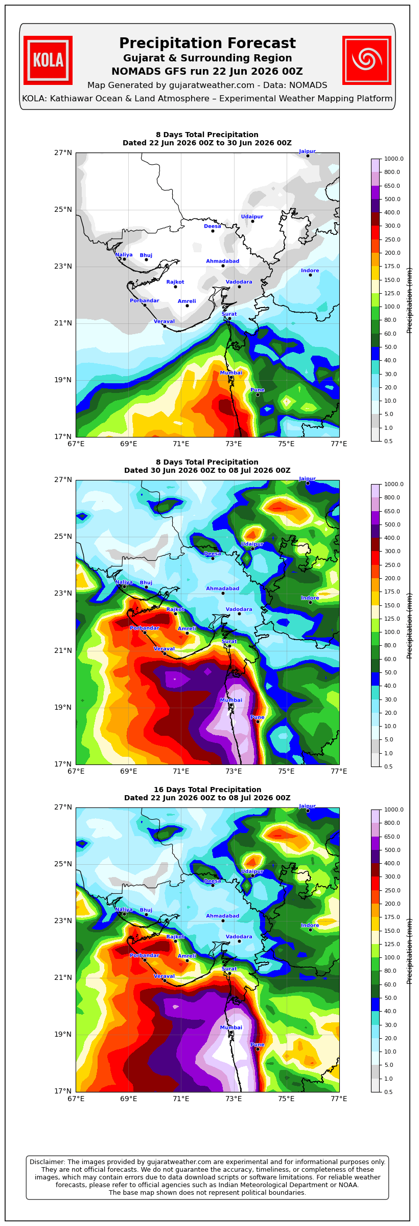
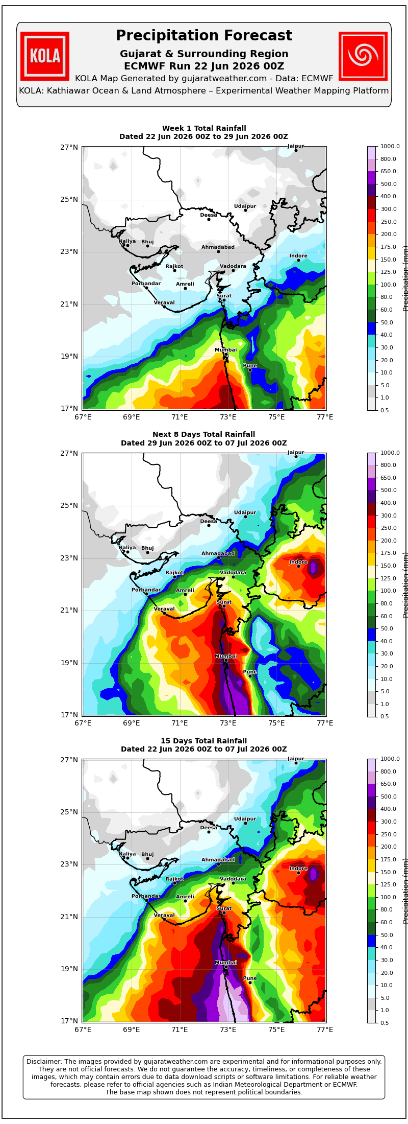
સૌરાષ્ટ્ર, ગુજરાત અને કચ્છમાં 22 થી 28 જૂન 2026 દરમિયાન પ્રી-મોન્સૂન પ્રવૃત્તિ ચાલુ રહેવાની શક્યતા
દક્ષિણ-પશ્ચિમ ચોમાસું 2026 ની આગેકૂચ
IMD બુલેટિન મુજબ કેટલીક પરિસ્થિતિઓ:
દક્ષિણ-પશ્ચિમ ચોમાસું આજે 22 જૂન 2026ના રોજ મધ્ય અરબી સમુદ્રના વધુ ભાગોમાં, મહારાષ્ટ્ર, તેલંગાણામાં, કર્ણાટકના બાકીના ભાગોમાં, છત્તીસગઢના કેટલાક ભાગોમાં તેમજ ઓડિશા, ઝારખંડ અને બિહારના વધુ કેટલાક ભાગોમાં આગળ વધ્યું છે.
22 જૂન 2026ના રોજ ચોમાસાની ઉત્તર સીમા (Northern Limit of Monsoon – NLM) 19°N/60°E, 19°N/65°E, 18.8°N/70°E, અલીબાગ, પુણે, નિઝામાબાદ, દંતેવાડા, બાલાંગીર, સુંદરગઢ, ચાત્રા, ગયા, મુઝફ્ફરપુર અને 28.3°N/83°Eમાંથી પસાર થાય છે.
આગામી 48 કલાક દરમિયાન મધ્ય અરબી સમુદ્રના બાકીના ભાગોમાં, મહારાષ્ટ્રના વધુ ભાગોમાં (મુંબઈ સહિત), તેલંગાણા અને ઓડિશાના બાકીના ભાગોમાં તેમજ છત્તીસગઢ, ઝારખંડ અને બિહારના વધુ કેટલાક ભાગોમાં દક્ષિણ-પશ્ચિમ ચોમાસાની વધુ આગેકૂચ માટે પરિસ્થિતિ અનુકૂળ છે.
ઉત્તર ગુજરાતથી સૌરાષ્ટ્ર થઈ પશ્ચિમ-મધ્ય અરબી સમુદ્ર સુધીનો ટ્રફ સરેરાશ સમુદ્ર સપાટીથી 3.1 કિ.મી. ઊંચાઈએ યથાવત્ છે.
સૌરાષ્ટ્ર, ગુજરાત અને કચ્છ માટે હવામાન આગાહી (22 થી 28 જૂન 2026)
પ્રી-મોન્સૂન પ્રવૃત્તિ
આગાહી સમયગાળા દરમિયાન આઇસોલેટેડ પ્રી-મોન્સૂન વરસાદી પ્રવૃત્તિ ચાલુ રહેવાની શક્યતા છે.
આઇસોલેટેડ (Isolated) નો અર્થ વિસ્તારના 1% થી 25% ભાગમાં વરસાદી પ્રવૃત્તિ થવાની શક્યતા.
પવનો
આગાહી સમયગાળા દરમિયાન મુખ્યત્વે દક્ષિણ-પશ્ચિમ દિશાના પવનો ફૂંકાવાની શક્યતા છે.
પવનની ઝડપ સામાન્ય રીતે 15 કિ.મી./કલાકથી 40 કિ.મી./કલાક વચ્ચે રહેવાની શક્યતા છે. પ્રી-મોન્સૂન પ્રવૃત્તિ દરમિયાન પવનની દિશામાં પણ ક્યારેક ફેરફાર થઈ શકે છે.
આગળના સંકેતો
આગાહી સમયગાળા પછીના અઠવાડિયામાં ગુજરાત રાજ્યના કેટલાક ભાગોમાં દક્ષિણ-પશ્ચિમ ચોમાસાની એન્ટ્રી માટેની શક્યતા અનુકૂળ જણાય છે.
આ અંગેના આધારરૂપ સંકેતો માટે ઉપર દર્શાવેલ વરસાદ ના નકશા આપેલ છે.
Caution: Please refer/rely on IMD/RSMC Bulletins/Advisories for Storms & Weather related matter.
સાવચેતી: સ્ટોર્મ કે હવામાન અંગે ની માહિતી માટે ભારતીય હવામાન ખાતા/ગવર્મેન્ટ ના બુલેટીન/સુચના પર નિર્ભર રહેવું.
Read Comment Policy – કમેન્ટ માટે માર્ગદર્શન વાંચો
How To Upload Profile Picture For WordPress – વર્ડપ્રેસ માં પ્રોફાઈલ પિક્ચર કેમ રાખવું
Forecast In Akila Daily Dated 22nd June 2026
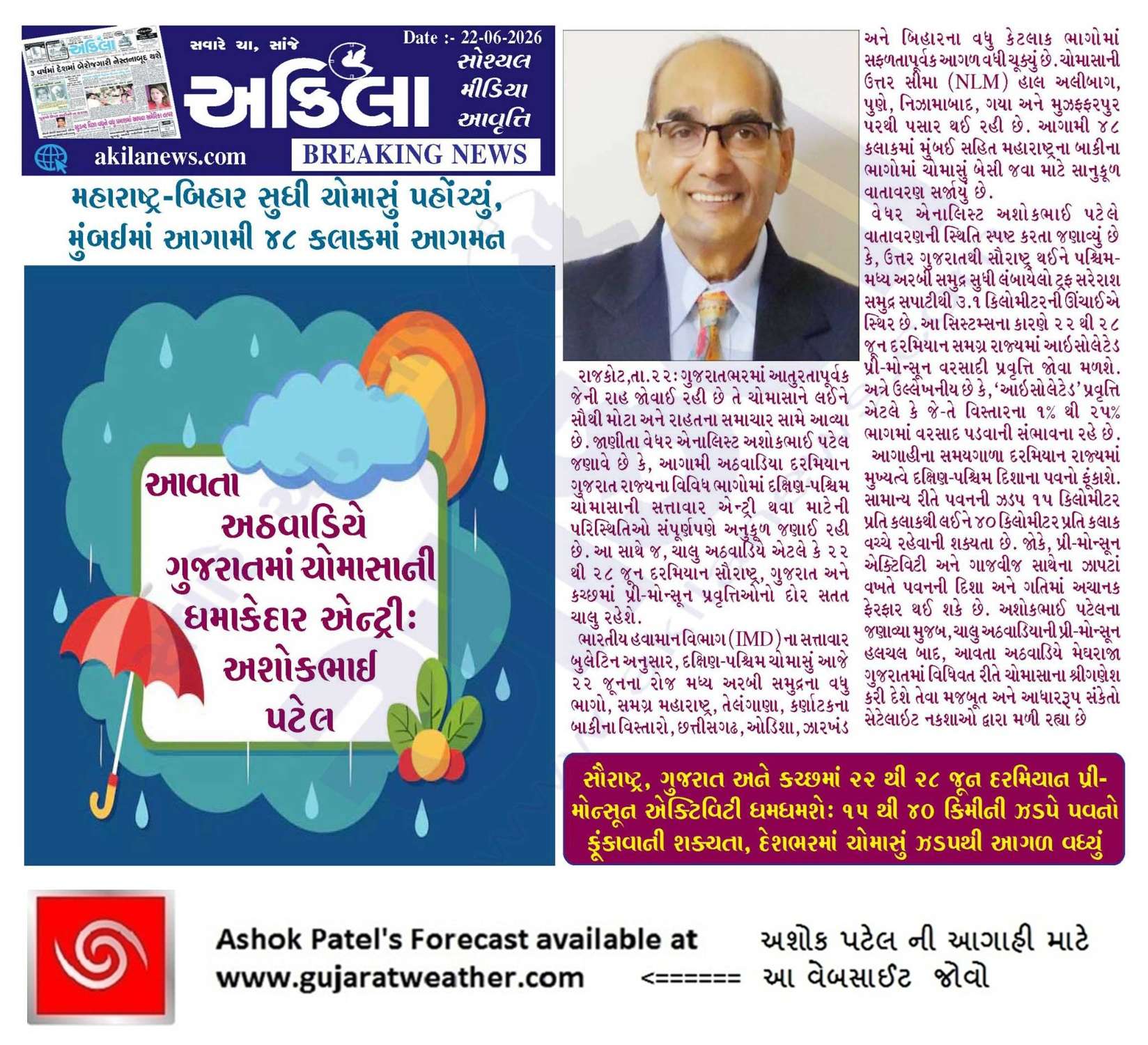
Forecast In Sanj Samachar Daily Dated 22nd June 2026
Retd Dhiren Patel.. એવી લોકવાયકા છે કે જો મલ્હાર રાગ ગાવામાં આવે તો વરસાદને વરસવું જ પડે.ધીરેનભાઈ તમને આ રાગ આવડે છે ?
Umesh bhai mane only foot ma varsad pade to mapta aavde……ane jotto fodta aavde …….baki tame master cho kane hath dai try karo ….,med pade to kejo……ha ha ha
Models pan “મૃગજળ” jeva thai gaya chhe.
ઘેન છે વાતાવરણમાં એટલું,
વરસાદને ઝોકું ન આવે તો ઘણું….
વગર વરસાદે કવિઓ Tragedy Song લખવા માંડયા છે.કવિ પૂછે છે કે Romantic song લખવું છે..જો નજીકમાં કોઈ સારા સંજોગ હોય તો..!!!
Sir ek vat nat samjati prasant maha Sagar ma.to ghana badha region chhe 3, 3.4, 4, pan alnino mate 3.4 region nu j temprature kem count thay ?
El Nino ni vyakhya te pramaney chhe.
સરળ ભાષામાં કારણો: Niño 3 વિસ્તાર પૂર્વ (Eastern Pacific) તરફ છે. અહીં તાપમાનમાં ઉતાર-ચઢાવ ઘણો વધુ થાય છે. સ્થાનિક અસરો (upwelling વગેરે)ને કારણે ક્યારેક તાપમાન બદલાય પણ ENSO મજબૂત ન હોય. Niño 4 વિસ્તાર પશ્ચિમ (Central-West Pacific) તરફ છે. અહીં ફેરફાર પ્રમાણમાં ઓછો હોય છે. ક્યારેક અહીં ગરમી વધે પણ વૈશ્વિક El Niño જેવી અસર ન થાય. Niño 3.4 વિસ્તાર આ બંનેની વચ્ચે છે. અહીં સમુદ્રનું તાપમાન અને વાતાવરણ (Trade Winds, Walker Circulation) વચ્ચેનો સંબંધ સૌથી મજબૂત જોવા મળે છે. ભારતનો મોનસૂન, અમેરિકા, ઓસ્ટ્રેલિયા સહિત વિશ્વના ઘણા ભાગોના હવામાન સાથે પણ આ વિસ્તારનો સંબંધ સૌથી વિશ્વસનીય મળ્યો છે. એટલે જ… Read more »
Nino3.4 ne El Nino na criteria ma ganel chhe. Samagra DUniya ne asar kare chhe evu kaheva ma aavey chhe.
Parantu koi ye aa babat par dhyan nathi aapyu:
Niño 3.4 = 1.7% of global oceans
Niño 3.4 = 3.5% of the 20°N–20°S tropical belt
Tropical belt is about 28× larger than Nino3.4
Global oceans are about 58× larger than Nino3.4
30-6 pachhi badha model thodu ghanu saru batave chhe ek GSF ne j vandho chhe.
Gsf pan apna raste avshe,icon model pan positive che,ECMWF સૌથી વધુ વિશ્વાસુ..એ પણ આપણા રસ્તે છે..સારી બાબત
Rainfall 4wik ma 2wik ma સારુ btave chhe joye have su thay chhe
ઠાકુર તો ગ્યો..
ઠાકુર તો આવી ગયો શાપર રાજકોટ માં
Sir Rajkot jamnagar ma el nino ni asar vadhu rese image attached karel chhe aavi sansanati kari ne khedut ne darava ni su jarur chhe
સર આજે અમારી બાજું વાતાવરણ ઘણુ બદલાય ગયું છે પવન ની ગતિ પણ ધીમી થઈ ગઈ છે કાળા વાદળો આજે ભેગા થાય છે એવું લાગે છે બફારો પણ જોરદાર છે
Gai kale rate 12 vage vijdio thti ti North – Northwest ma to achanak aasha jagiti k kaik thse 1kad kalak ma pn nothing happened 🙂
Jo k varsad aavigya krta varsad ni rah jova ma bv mja che 🙂 hahaha
તારીખ:- 26 જૂન 2026 આજની પરિસ્થિતિ ભારતીય હવામાન વિભાગ અનુસાર મીડ ડે બુલેટિન – ચોમાસાની ઉત્તર સીમા હાલ 20°N/60°E, 20°N/65°E, 20°N/70°E, સુરત, ઇન્દોર, મંડલા, ડાલ્ટોનગંજ, મોતીહારી અને 28.3°N/83°E પરથી પસાર થાય છે. – આગામી 3-4 દિવસ દરમિયાન દક્ષિણ-પશ્ચિમ ચોમાસું ઉત્તર અરબી સમુદ્રના વધુ ભાગો, ગુજરાત, મધ્ય પ્રદેશ, છત્તીસગઢના બાકીના ભાગો, ઝારખંડ, બિહાર તથા ઉત્તર પ્રદેશ અને ઉત્તરાખંડના કેટલાક વિસ્તારોમાં આગળ વધવા માટે પરિસ્થિતિ અનુકૂળ છે. – સરેરાશ સમુદ્ર સપાટી પરની મોસમી ટ્રફ હાલ રાજસ્થાનથી ઓડિશા સુધી ઉત્તર મધ્ય પ્રદેશ અને છત્તીસગઢ પરથી પસાર થાય છે. – ઉત્તર ગુજરાત અને સૌરાષ્ટ્ર ઉપર 3.1 થી 5.8 કિમી ઊંચાઈએ એક ઉપરવર્તી ચક્રવાતીય પરિભ્રમણ… Read more »
Ashok sir. 22 thi 28 ni agahi ma pri moonson activety ma 25 tarikhe thi ghatado ayvo anu karan suka pavano hoy sake.
Suka pavan june end thi nabda pde che etle 1 July thi vatavarn Sudhrse Gujarat ma Bob ma 3 July aaspas System bnvani skytao dekhai che ane Mumbai coast najik tyare UAC bnse ane Shear Zone bni ske pn main Wd tyare j Pasar thai evu dekhai che joye hve agad kevu rahe che July 1st week main che hve to.
Aje sir surat ma vatavaran ak dam garmi vadu che ne pavan zadap pan ghati gay che have sara varshad ni asha rakhi sakay agad na divso ma
Ahi KOLA Maps temaj bija Maps chhe. Te jovo and andaj karo.
Jem Windy badha jovey chhe tem.
Sir tarikh 26/27 ma Gujarat Rajasthan border
Par imd gsf pramane 700hp ek uac batave che
To teno labh madi shke
Te Border vistar ne lagu padey.
biju ke jyan tamo charts jovo chho tyan varsad na pan map hoy…ema chhe ?
સર હું ઘણા દિવસ વરસાદી મોડલ પર નજર રાખી રહીયો શું ખાસ કરીને કોરા માં વાવવા મટે ઘણા બધા મોડલ 28 થી 1 માં કોસ્ટેલ svrast માં રેન બતાવે શે અને vandear gravund માં 28 થી 4 સુધી કોસ્ટલ એરિયા દીવ કોડીનાર માં સરો વરસાદ બતાવે શે પણ canfyusan imd gaf ને લય ને સે જે 4 સુધી ખાસ કઈ હલસલ બતાવતું નથી તો મારી તમને વિનંતી સે એક વખત ટાઇમ લઈ ને કોડીનાર અને દીવ vandar gravund તમે સેક કરી જવાબ આપજો કેમ કે એક વખત વરસાદ સલું થશે તો લબો સમય વરસાદ સાલશે અને હવે મોડું થાય શે… Read more »
સર જવાબ તો આપો
Koi jawab ni apexa rakhta nahi.
Nirnay tamarey karvano chhe.
Ahi 3 thi4 Model nu ek week biju week em, temaj 5 divas and 10 divas em,
temaj dar roj na Varsad babat pan ahi aapel chhe je 15 divas and 16 divas maate chhe.
Andaj Apnaa Apnaa !
30 june kaj ma vavetar kari dyo korama , thai jase saro varsad 1 to 4 July ma
Varsad thai Jai pachi avish Tamara shop par thandu piva
અરે ભાઈ હું તો તમને ઓલક્તો નથી તમને કેમ ખબર મારે શોપ પણ સે ?
Tamara papa virabhai ne mara papa na varsho juna sabandh
મિત્રો ગુજરાત માં તો ઠીક ઠીક વરસાદ ભાગમાં આવશે એવું લાગે છે.પણ પક્ષિમ સૌરાષ્ટ્ર વિસ્તારમાં 10 જુલાઈ સુધીમાં કાંઈ પણ વરસાદ ભાગમાં આવે એવું લાગતું નથી.એટલે ખોટું જોખમ કરતા નહીં વાવેતર કરવામાં ખાસ કરીને દ્વારકા.પોરબંદર.જામનગર.
Gujarat Rajasthan Maharashtra ma el nino vathu asar batave che
Ane agad na Samy ma iod pan bav positive nathi atle week monsun manvu na mjo pan faj ma nathi system Bihar side no track vathu jukav rahai
અશોકભાઈ નમસ્તે ! જય શ્રીકૃષ્ણ જય ઉમિયાજી આજના દિવ્ય ભાસ્કર પેપર માં હેડિંગમાં છે ચોમાસાની ગુજરાતમાં એન્ટ્રી થઈ ગઈ ત્રણ દિવસ પછી ગતિ પકડશે અને દેશ ભરમાં આવી જશે.
Saru !
સાહેબ હું ચોમાસું ક્યારે આવશે એ નથી પુછતો એ તો IMD ની ઇચ્છા હશે ત્યારે ડિકલર કરી દેશે. પણ વરસાદ ક્યારે આવશે ? થાકી ગયા છી હવે તો રાહ જોઈ જોઈને અને ગરમી ખાઇ ખાઈને
Te babat Gujarati ma lakhel chhe.
1st July pachi vatavaran sudharse etle varsad ni aasha rakhvi. Tya sudhi gharmi khaavi padse
Sir kaik to આગોતરું આપો જેથી કરીને અમે બિયારણ બદલાવ કરવો કે બીજું આયોજન કરવુ જાણીએ છીએ તમે લાંબા ગાળા ની આગાહી નથી કરતા પન કંઈક તો આગોતરુ આપો 7દીવસ પછી નૂ કોઈ નક્કી ના હોય પણ તમારૂ આપેલૂ આગોતર પન 90 to 96 % હોઈ se please
Aa update ma shu aapel chhe?
આગળના સંકેતો
આગાહી સમયગાળા પછીના અઠવાડિયામાં ગુજરાત રાજ્યના કેટલાક ભાગોમાં દક્ષિણ-પશ્ચિમ ચોમાસાની એન્ટ્રી માટેની શક્યતા અનુકૂળ જણાય છે.
આ અંગેના આધારરૂપ સંકેતો માટે ઉપર દર્શાવેલ વરસાદ ના નકશા આપેલ છે.
Sar એરર bav aave gu .vedhar ma
Etle ?
Sar error aavu lakhel aave ane 1. 2. Divas nathi khultu.
Vigat thi problem hoy te janavo
સર નેટ નો ઇસ્યુ હોય એટલે તફલિક થતી હોય આપણી સાઈડ ખોલવામાં ક્યારેક ક્યારેક બાકી કય પ્રોબ્લેમ લાગતો નથી સરસ ચાલે છે
Sir IMD chart to dur bhagta jay apna thi su chhe aa badhu javab apo tme ?
IMD chart 10 divas na chhe.
Bija 15 days and 16 divas hoy chhe.
Sarji namskar bapu aa vakhte dwarka baju varsad kiyare vadhamna karse. ? Julay na pahala week ma asha rakhi sakay? Please answer sarji
IMD mujab haal kram by kram varo aavey em lakhey chhe.
Aaj ni commet vachi kudrat ne Araj karel che.
*તુ વરસે તો મન મુકીને વરસજે,*
*કોઈ તને કંઈ નહીં કહે.*
*રસ્તાના ખાડા તો અમે પુરી દઇશું,*
*પણ પેટના ખાડા તારા સિવાય કોઈ નહીં પુરે!!*
Amathu nathi kidhu “mehuliya varshya j Bhala”.
પેટ ના ખાડા તો ગમે એમ ભરાઈ જાય,
પણ
મન ના ખાડા કેમ કરી બુરાસે
kavi aaya manvi na pet na khada ni vat nathi karta……..abola pashu pakshi ni vat kare che.
A vkte to primonsoon activity bhu auchi 6
તારીખ:- 25 જૂન 2026 આજની પરિસ્થિતિ ભારતીય હવામાન વિભાગ અનુસાર મીડ ડે બુલેટિન – દક્ષિણ-પશ્ચિમ ચોમાસાની ઉત્તર સીમા હાલ 20°N/60°E, 20°N/65°E, 20°N/70°E, સુરત, ઈન્દોર, મંડલા, ડાલ્ટોનગંજ, મોતીહારી અને 28.3°N/83°E પરથી પસાર થાય છે. – આગામી 3 થી 4 દિવસ દરમિયાન ચોમાસું ઉત્તર અરબી સમુદ્ર, ગુજરાતના વધુ ભાગો, મધ્ય પ્રદેશ, છત્તીસગઢના બાકી વિસ્તારો, ઝારખંડ, બિહાર તેમજ ઉત્તર પ્રદેશ અને ઉત્તરાખંડના કેટલાક ભાગોમાં આગળ વધવા માટે પરિસ્થિતિ અનુકૂળ છે. • સમુદ્ર સપાટી પર મોસમી ટ્રફ ઉત્તર રાજસ્થાનથી બિહાર સુધી હરિયાણા અને ઉત્તર પ્રદેશ પરથી પસાર થાય છે અને સરેરાશ સમુદ્ર સપાટીથી 0.9 કિમી સુધી વિસ્તરે છે. • પૂર્વ ઉત્તર પ્રદેશ ઉપરનું ઉપરવર્તી… Read more »
Have imd ek be di ma daxin saurashra ma pan vagar varsade chomachu besadi deshe
Evi jarur na padey IMD ne. Arabian Sea mathi Surat aavi gayu etle Surat thi Indore sudhi ma gamey tyan line khechi shakey.
Jo Saurashtra Gir- SOmnath/ Amreli vigere ma varsad padshe toe Saurashtra Coastal patti declare thay.
Haal 3-4 divas nu aantaru nakhi didhu chhe Gujarat Rajya maate.
Jya sudhi suka pavan nadse tya sudhi sara varsad no chance dekhato j nathi gujarat ma and atyare to Suko Pradesh gnato Rajasthan ma darroj varsad hoi che kyay ne kyay vistar ma June month Above average thai gyo tya and Gujarat ma Pela models June end saro varsad btavta hta e to possible na thyu Hve to July first week jovanu Su thai che.
દિવસે ને દિવસે મોડલો દૂર ભાગતા જાય છે ખેડૂતો ની કઠણાઈ તો નથી બેઠી ને????
Sir .. આજ જોતા એવું લાગે 9/10 તારીખ ક્યાં નથી
Ashokbhai chomasu surat ma che to dhom tadko che vadla pan na na barobar che varsad nathi
Chomasu IMD pramaney best line khenchvani hoy. Indore baju pan besi gayu and Arabian ni line khechvi padey to ukel ma Surat mathi pass kari (varsad pan hato te baju)
સર આજ ની અપડેટ જોતા તા એવું લાગે છે કે “ઠાકુર તો ગયો ગુજરાત મુકી ને દૂર.. તમારુ શું કહેવું છે આજની અપડેટ વિશે..
Aaj ni kai update? IMD ke?
Windy ma
WINDY ma Run time shu te mahatva nu chhe. Darek model windy ma alag alag time update thay chhe.
Imd gfs ni vat kare se, saheb
Pre-Monsoon Activity vadharo thashe ke ghatado aaj thi ?
Sir, ECMWF AIFS Monday thi j varsad batave chhe.
Bija badha model ena raste chalva joiye because a vadhare accurate chhe.
ECMWF regular vadhu sachot ganay. AIF haju navu ganay and teni Vishvaniyata babat khyal nathi. Anubhav thaay tyare khabar padey.
Sir amdavad ma Kai j nathi bafaro ne taap 6 to aap janavso k aaje aavse varsad
Pre-Monsoon activity ma lottery system hoy.
Chomasu besva maate haju raah jovani thay.
Chomasu Surat & Indore sudhi avyu chhe.
Haal Chomasu kramash aagad chaley em IMD kahey chhe.
Haji raah jovani rese thoda diwas. 1st July sudhi to kai nathi. Koi diwas lottery lagi jay to nasib
kola mathi to gas nikali gayo
Bhai aa vakhate evuj che. Chomasa ni sharuat nabdi j che. Haji ek sudhi kai dekhatu nathi.
Ek week sudhi kai dekhatu nathi em
varsad vagar chomasu besadi didhu.
Kyan?
Bhavnagara ma?
અમારે દ.ગુજરાત માં.
અમારે વાવણી લાયક પણ નથી..
સરકારી આંકડા મુજબ તાલુકા મથકો એ વરસાદ હોય પણ એ સીવાય બીજા ગામોમાં વરસાદ નથી.
Chomasu line khenchvama IMD maate kathin kaam hoy chhe.
Line ne continue rakhvi padey. M.P. Baju varsad hato and Surat ma hato etle Arabian Sea mathi line sidhi Surat and Indore em khenchel chhe.
Kyarek Line khenchel hoy tyan sudhina amuk gam ma nondh patra Varsad na pan hoy chhata line continue rakhva aam karvu padey.
E to evuj che bhai. Vagar varsade chomasu besadi de ane chomasa ni vidaay pachi pan varsad padyaj kare.
IMD na amuk niyamo hoy chhe…te mujab te chaley.
Badha models jota chomasu farithi nabdu padi sake che ane Surat thi agal aavta atki sake che. 30th June sudhi to kai dekhato che nai varsad. Varsad chalu thase toy 1st July thij chalu thase evu lagi rahyu che.
Pratik bhai ae imd buletin gujrati ma mukyu nahi
1.55 na comment jovo
namaste sir
me amuk varsho thi dhyan aapyu chhe ke surat maa varsad lagbhag savar na time ma ja padto hoy chhe, bapor pachhi lagbhag nahi jevo hoy chhe to enu karan shun hoy shake….?
Evu kai mark karel nathi
Trough pendulum ni jem fare savaare anukul jgyaye hoye toh varsaad pde.
સાહેબ, હાલ ઘણા સમાચાર અને હવામાન અહેવાલોમાં દક્ષિણ સૌરાષ્ટ્ર (જેમ કે જૂનાગઢ, ગિર સોમનાથ, અમરેલી) પર વધુ ભાર મૂકવામાં આવે છે.પરંતુ જામનગર જિલ્લા નો ઘણી વખત ખાસ ઉલ્લેખ થતો નથી.તો આપના મત મુજબ આવનારા દિવસોમાં જામનગર જિલ્લામાં વરસાદનું પ્રમાણ કેવું રહેશે તે જણાવશો?
Chomasu pahela Dakshin Saurashtra patti ma besey pachhi kramash agad vadhey…tyare tamaro varo aavey.
ચોમાસા ના શ્રી ગણેશ થઈ ગયા ને સર ગુજરાતમાં?
Surat sudhi pahonchyu chhe.
Porbandar ma zapta avta e pan bandh thai gya last 5 thi 6 divas thya Hve to vaddao pn sav ocha thai gya and Bafaro ane Tadko continue chalu che.models jota hju 28 ke 29 june sudhi to kai dekhatu nathi.
Ajthi pavan nu jor vadhi gayu ketala divs rahse
હવે તો વરસાદ વગર અહક થાય છે
Ashok sir. Aaj nu vataavaran jota avo lage ke pre monnson actiy vity ma ghatado thayu hoy to kal thi pachu vadhi sake
Amare bharuch ma chomasu nti besu to pri monsoon activity possible khari
yes
South Gujarat ma Chomasu Surat sudhi aavyu.
South Gujarat ma chomasa nu aagmaan!!
Welcome south monsoon in south Gujarat- IMD