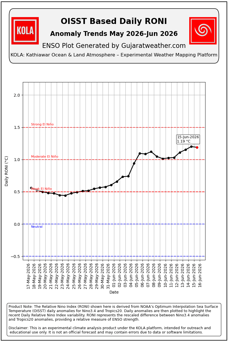
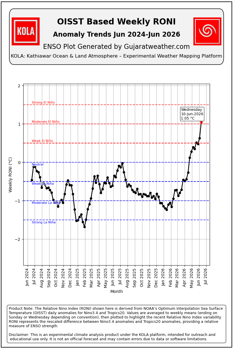
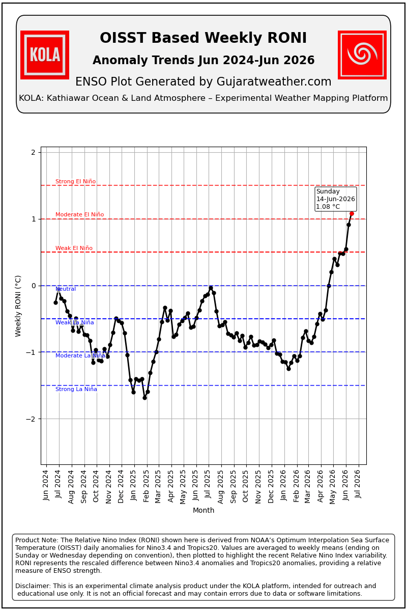
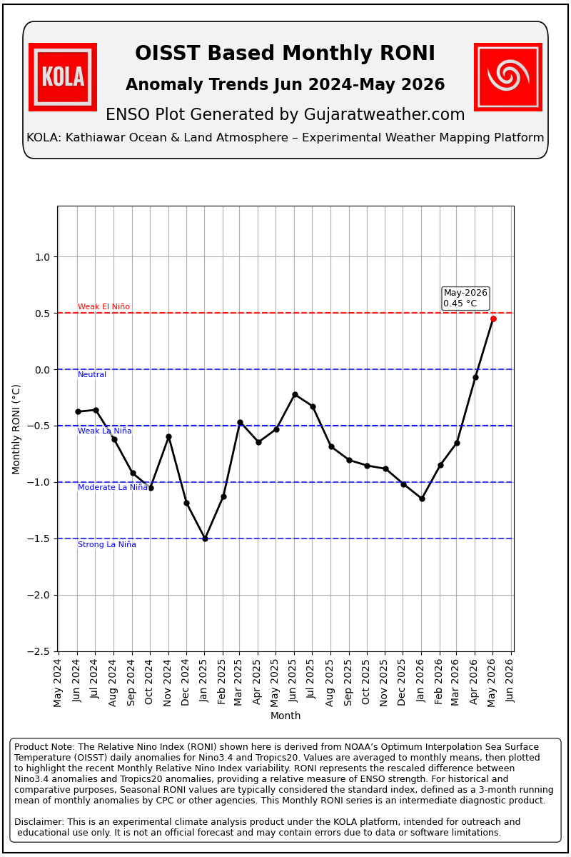
The KOLA Relative Oceanic Nino Index products based on OISST Daily SST Data
1. OISST Daily RONI
2. OISST Weekly RONI every Wednesday
3. OISST Weekly RONI every Sunday
4. OISST Monthly RONI for completed Months
5. OISST Current Month mean RONI
Date: 16-06-2026
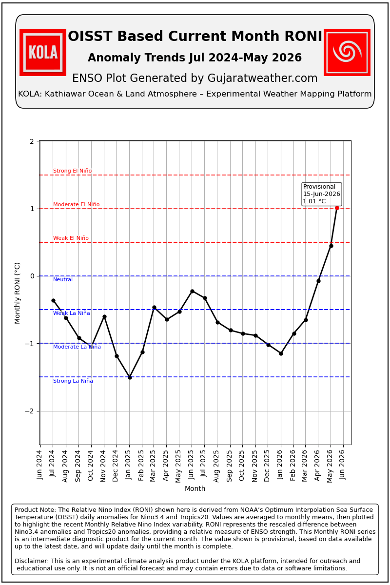
The Relative Oceanic Niño Index (RONI) is defined as the three month running average of the monthly relative Niño 3.4 anomaly. Historical El Niño and La Niña events will be categorized based on this index, specifically when there are five or more consecutive, overlapping three-month seasons where the RONI is greater than 0.5C (El Niño) or less than -0.5C (La Niña).
RONI is calculated using the ERSST.v5 monthly data.
This proposed change will have two primary benefits for ENSO monitoring and prediction: 1) the relative sea surface temperature index better identifies current and past El Niño and La Niña events because it is less sensitive to the chosen base climatology period. This allows for comparison of events across the lengthy climate record.
KOLA has developed various plots listed above for preliminary monitoring of the upcoming El Nino episode from OISST Daily Data. The same is available in the Menu at this link RONI Graphs
OISST દૈનિક SST ડેટા આધારિત KOLA Relative Oceanic Nino Index (RONI) પ્રોડક્ટ્સ
- OISST દૈનિક RONI
- OISST સાપ્તાહિક RONI (દર બુધવારે)
- OISST સાપ્તાહિક RONI (દર રવિવારે)
- પૂર્ણ થયેલા મહિનાઓ માટે OISST માસિક RONI
- OISST ચાલુ મહિનાનો સરેરાશ RONI
તારીખ: 16-06-2026
Relative Oceanic Niño Index (RONI) ની વ્યાખ્યા માસિક Relative Niño 3.4 Anomaly ના સતત ત્રણ મહિનાના ચાલતા સરેરાશ (Three-Month Running Average) તરીકે કરવામાં આવે છે. ઐતિહાસિક El Niño અને La Niña ઘટનાઓનું વર્ગીકરણ આ સૂચકાંકના આધારે કરવામાં આવશે. ખાસ કરીને, જ્યારે સતત અને એકબીજા સાથે ઓવરલેપ થતી પાંચ અથવા તેથી વધુ ત્રણ-માસીય ઋતુઓ દરમિયાન RONI +0.5°C કરતાં વધુ હોય ત્યારે તેને El Niño, અને -0.5°C કરતાં ઓછું હોય ત્યારે તેને La Niña તરીકે ગણવામાં આવશે.
RONI ની ગણતરી માસિક ERSST.v5 ડેટાના આધારે કરવામાં આવે છે.
ENSO ના મોનિટરિંગ અને આગાહીમાં આ પ્રસ્તાવિત ફેરફારના બે મુખ્ય લાભ છે:
- Relative Sea Surface Temperature Index વર્તમાન અને ભૂતકાળની El Niño તથા La Niña ઘટનાઓને વધુ સારી રીતે ઓળખે છે, કારણ કે તે પસંદ કરાયેલા આધારભૂત ક્લાઇમેટોલોજી સમયગાળાની અસર પ્રત્યે ઓછી સંવેદનશીલતા ધરાવે છે.
- આથી લાંબા ગાળાના આબોહવા રેકોર્ડમાં વિવિધ ENSO ઘટનાઓની વધુ યોગ્ય અને સીધી સરખામણી શક્ય બને છે.
KOLA દ્વારા ઉપર દર્શાવેલા વિવિધ પ્લોટ્સ OISST દૈનિક ડેટાના આધારે વિકસાવવામાં આવ્યા છે, જેથી આગામી El Niño પરિસ્થિતિના પ્રાથમિક મોનિટરિંગ માટે તેનો ઉપયોગ કરી શકાય.
Daily RONI based on OISST Daily SST Data
Weekly RONI for Week ending Wednesday based on OISST Dailly Data
Weekly RONI for Week ending Sunday based on OISST Dailly Data
OISST Based Monthly RONI (Completed Month)
Vadodara ma 10.15 pm thi saro varsad padi rahyo che.
અમેતો તૈયાર ભજીયા ખાવા વાળા છીએ સાહેબ
તમો તથા જાણકાર મીત્રો અમારા જેવા માટે જે જાણકારી આપો છો તે બદલ આભાર
Vadodara sama rasta bhina thya
Bhadli vakya pramane jo aje kyay varshad chhe to varshad khechavani ke dushkal padvani sambhavna chhe.
સર વેસ્ટર્ન ડિસ્ટબન્સ જનરલી ક્યાં સમય સુધી આવતા હોય છે.
WD te pan UAC j hoy chhe. Normally te vadhu North ma hoy.
Monsoon Low Normally North Rajasthan thi Bay of Bengal baju hoy.
Jay mataji sir…thanks for new information aapva mate…aaje amara thi South ma dhimi dhimi vijdi thay 6e…
અત્યારે પૂર્વ દિશામાં જોરદાર વીજળી થાય છે
Botad paliyad ma chanta aviya
Thankyou sirji…graph upar highlight kri didhu..
Jsk સર… અપડેટ બદલ આભાર
છેલ્લી લાઈન માં જે છે.. 18 જૂન થી ફ્રેશ wd ઉત્તર…. પક્ષિમ ભારત ને અસર કરે તો ઇનો અર્થ જો ચોમાસુ આગળ હાલવા માટે ગણીયે તો તાં આડઅસર ગણવાની કે?
Yes.
એટલે આ બધું ચોમાસા માટે સારું કે નરસું?
Aa Badha maate nathi.
Jene vadhu janvanu hoy tena maate chhe. Jene RONI ni ABCD khyal hoy tena maate chhe.
RONI etle El Nino and La Nina maate Index chhe.
અશોકભાઈ આનો મતલબ કંઇ સમજનો નથી તમારા અભ્યાસ મુજબ જરા વિસ્તૃત માહિતી આપવા નમ્ર વિનંતી
Aa graph em suchvey chhe ke El Nino taraf gadi jaay chhe.
Jsk સર… હા જુલાઈ નો ગ્રાફ જોતા એવું લાગે કે ગાડી પેલા ગીયર માં પડેહ અલનીનો બાજુ જવામાં
તારીખ: 17 જૂન 2026 આજની પરિસ્થિતિ ભારતીય હવામાન વિભાગ (IMD) મુજબ મિડ-ડે બુલેટિન અનુસાર – નૈઋત્યના ચોમાસાની ઉત્તર સીમા (NLM) હાલ 18°N/60°E, 18°N/65°E, 18°N/70°E, હરનાઈ, સોલાપુર, હૈદરાબાદ, ભદ્રાચલમ, કોરાપુટ, ફુલબાની, રાંચી, જામુઈ, મુઝફ્ફરપુર અને 28.3°N/83°E પરથી પસાર થાય છે. – આગામી 4 થી 5 દિવસ દરમિયાન નૈઋત્યનું ચોમાસું તેલંગાણા, ઓડિશા, ઝારખંડ, બિહાર અને છત્તીસગઢના કેટલાક વધુ ભાગોમાં આગળ વધવા માટે પરિસ્થિતિ અનુકૂળ છે. – સરેરાશ સમુદ્ર સપાટી પર પંજાબથી બિહાર સુધી હરિયાણા અને ઉત્તર પ્રદેશ પરથી પસાર થતી મોસમી ટ્રફ (Seasonal Trough) યથાવત છે. – એક વેસ્ટર્ન ડિસ્ટર્બન્સ ઉત્તર પાકિસ્તાન અને આસપાસના વિસ્તારો ઉપર 3.1 કિમી ઊંચાઈએ ચક્રવાતીય પરિભ્રમણ સ્વરૂપે… Read more »
Sir aavu amare study ma aavel civil ma environment subject ma but jaju yad nati kai