Monsoon Expected To Progress Over Gujarat Region & Enter Saurashtra & Kutch Zone During Forecast Period 1st-8th July 2026
Advance of Southwest Monsoon 2026
Some conditions as per the IMD Bulletin:
- The Northern Limit of Monsoon (NLM) continues to pass through 20°N/60°E, 20°N/65°E, 20°N/70°E, Surat, Indore, Mandla, Daltonganj, Motihari and 28.3°N/83°E.
- Conditions are favorable for the further advance of the Southwest Monsoon into some more parts of the North Arabian Sea, Gujarat, Madhya Pradesh, remaining parts of Chhattisgarh, Jharkhand & Bihar, and parts of Uttar Pradesh & Uttarakhand during the next two days, and thereafter into some more parts of Madhya Pradesh, Uttar Pradesh, Uttarakhand, parts of Himachal Pradesh, Jammu & Kashmir, Ladakh, southeast Rajasthan and the remaining parts of Gujarat during the subsequent 2–3 days.
- The seasonal trough at mean sea level from Punjab to Bihar across Haryana and Uttar Pradesh persists.
- The trough extending from north-central Madhya Pradesh to the East-Central Arabian Sea across north Maharashtra persists and is now seen between 4.5 km and 5.8 km above mean sea level.
- An upper air cyclonic circulation (UAC) lies over north Odisha and neighborhood at 5.8 km above mean sea level.
- Another upper air cyclonic circulation lies over the north Bay of Bengal adjoining south Bangladesh between 1.5 km and 5.8 km above mean sea level.
- An upper air cyclonic circulation lies over Saurashtra at 3.1 km above mean sea level.
Expected Parameters:
Multiple Upper Air Cyclonic Circulations (UACs) are expected to develop, and at times may combine into a broader circulation. An east-west shear zone extending from Gujarat to West Bengal across Central India is also expected to develop. The distribution and intensity of rainfall will depend on the day-to-day evolution of these weather systems.
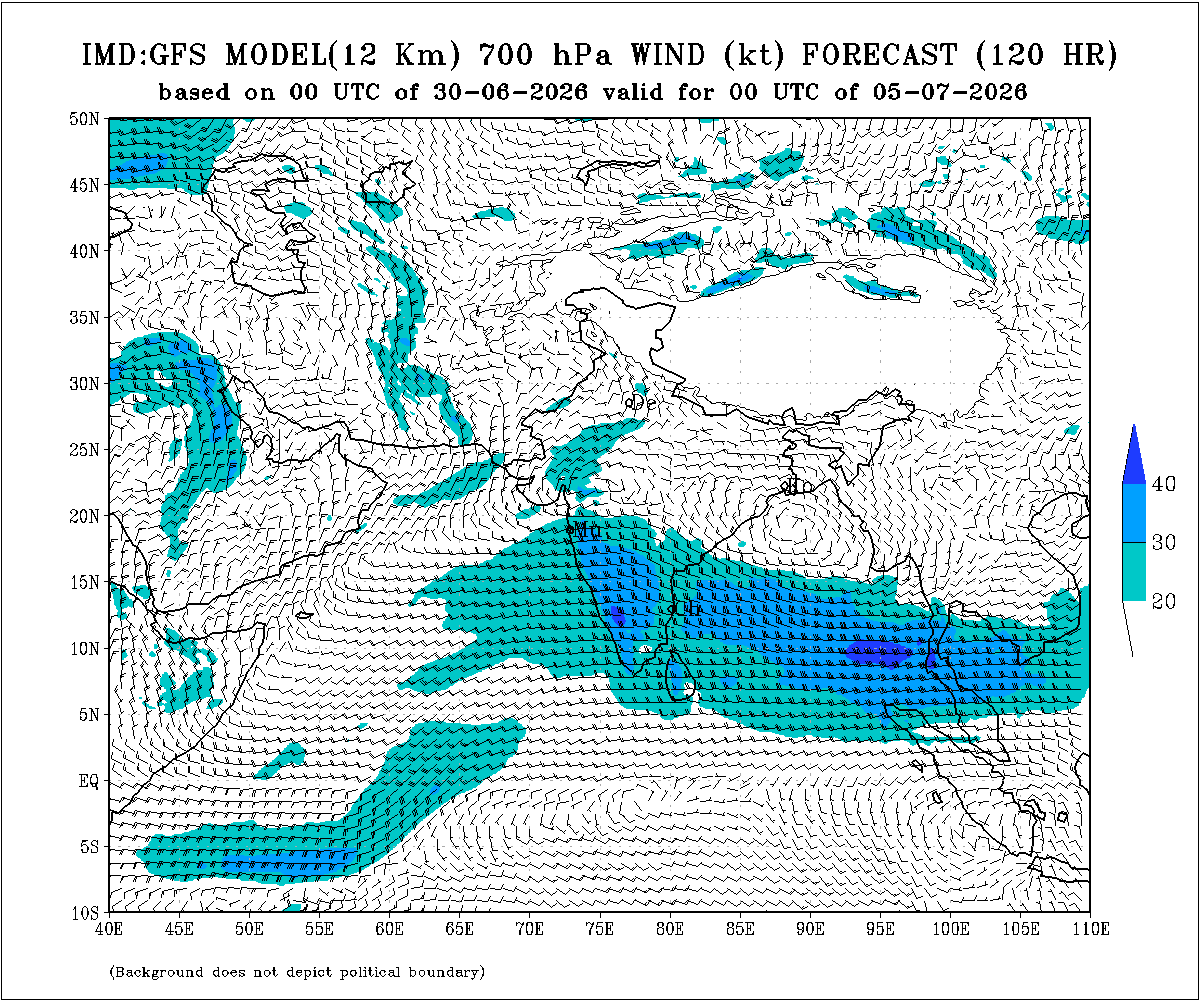
Weather Forecast for Saurashtra, Gujarat & Kutch (1st–8th July 2026)
Gujarat Region:
- Scattered to fairly widespread light to moderate rainfall on many days.
- Heavy to very heavy rainfall is likely on a few days.
- Thunderstorms, lightning and gusty winds of 40–50 kmph are likely at times.
Expected Total Rainfall Distribution
- 10% of the area: Up to 25 mm
- 30% of the area: 25–75 mm
- 60% of the area: 75–150 mm, with isolated places exceeding 250 mm
Saurashtra & Kutch
- Scattered light to moderate rainfall during the period.
- Isolated heavy to very heavy rainfall is likely on a day or two
- Thunderstorms, lightning and gusty winds of 40–50 kmph are likely at times.
Expected Total Rainfall Distribution:
- 25% of the area: Up to 25 mm
- 50% of the area: 25–75 mm
- 25% of the area: Above 75 mm, with some centers exceeding 150 mm
Summary:
- The Southwest Monsoon is expected to make further progress across Gujarat Region and advance into Saurashtra & Kutch during the forecast period.
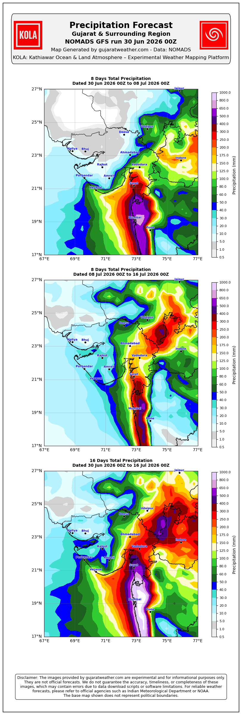
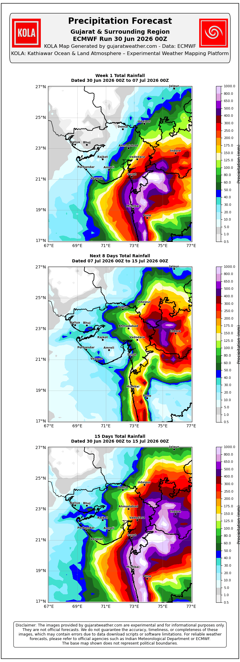
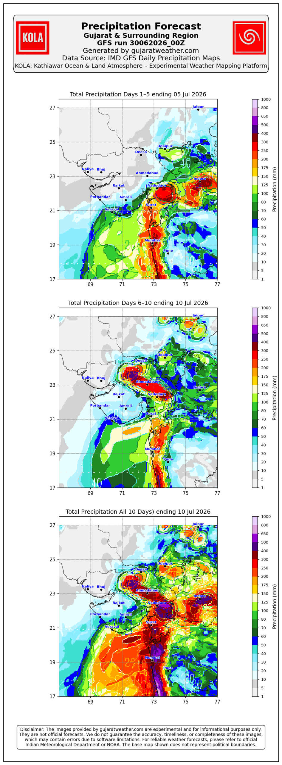
- Rainfall coverage and overall rainfall amounts are expected to increase across the entire State from 3rd July onward and will be significantly higher over Gujarat Region than over Saurashtra & Kutch.
Please refer to the maps given below for the supporting indications.
1 થી 8 જુલાઈ 2026 દરમિયાન ચોમાસું ગુજરાત રિજિયનમાં આગળ વધવાની તથા સૌરાષ્ટ્ર-કચ્છ ઝોનમાં પ્રવેશવાની શક્યતા
દક્ષિણપશ્ચિમ ચોમાસું 2026ની પ્રગતિ
IMD બુલેટિન મુજબ કેટલીક મુખ્ય પરિસ્થિતિઓ:
❖ ચોમાસાની ઉત્તર સીમા (Northern Limit of Monsoon – NLM) હાલ 20°N/60°E, 20°N/65°E, 20°N/70°E, સુરત, ઇન્દોર, મંડલા, ડાલ્ટનગંજ, મોતિહારી અને 28.3°N/83°E પરથી પસાર થાય છે.
❖ આગામી 2 દિવસ દરમિયાન દક્ષિણપશ્ચિમ ચોમાસું ઉત્તર અરબી સમુદ્રના વધુ ભાગો, ગુજરાત, મધ્ય પ્રદેશ, છત્તીસગઢના બાકીના ભાગો, ઝારખંડ, બિહાર તથા ઉત્તર પ્રદેશ અને ઉત્તરાખંડના કેટલાક ભાગોમાં આગળ વધવા માટે પરિસ્થિતિ અનુકૂળ છે. ત્યારબાદના 2–3 દિવસ દરમિયાન મધ્ય પ્રદેશ, ઉત્તર પ્રદેશ, ઉત્તરાખંડના વધુ ભાગો, હિમાચલ પ્રદેશ, જમ્મુ-કાશ્મીર, લદ્દાખ, દક્ષિણ-પૂર્વ રાજસ્થાન તથા ગુજરાતના બાકીના ભાગોમાં આગળ વધવાની શક્યતા છે.
❖ સમુદ્ર સપાટીએ પંજાબથી હરિયાણા અને ઉત્તર પ્રદેશ થઈ બિહાર સુધી વિસ્તરેલી મોસમી ટ્રફ યથાવત છે.
❖ ઉત્તર-મધ્ય મધ્ય પ્રદેશથી ઉત્તર મહારાષ્ટ્ર થઈ પૂર્વ-મધ્ય અરબી સમુદ્ર સુધી વિસ્તરેલી ટ્રફ યથાવત છે અને હાલમાં તે સરેરાશ સમુદ્ર સપાટીથી **4.5 થી 5.8 કિ.મી.**ની ઊંચાઈએ જોવા મળે છે.
❖ ઉત્તર ઓડિશા અને આસપાસના વિસ્તારમાં સરેરાશ સમુદ્ર સપાટીથી **5.8 કિ.મી.**ની ઊંચાઈએ અપર એર સાયક્લોનિક સર્ક્યુલેશન (UAC) આવેલું છે.
❖ દક્ષિણ બાંગ્લાદેશને અડીને આવેલા ઉત્તર બંગાળની ખાડી પર **1.5 થી 5.8 કિ.મી.**ની ઊંચાઈ વચ્ચે અન્ય એક અપર એર સાયક્લોનિક સર્ક્યુલેશન (UAC) આવેલું છે.
❖ સૌરાષ્ટ્ર ઉપર સરેરાશ સમુદ્ર સપાટીથી **3.1 કિ.મી.**ની ઊંચાઈએ અપર એર સાયક્લોનિક સર્ક્યુલેશન (UAC) આવેલું છે.
અપેક્ષિત પરિબળો:
એકથી વધુ અપર એર સાયક્લોનિક સર્ક્યુલેશન (UAC) વિકસે તેવી શક્યતા છે અને અમુક સમયે તે મળીને વિશાળ સર્ક્યુલેશનનું સ્વરૂપ ધારણ કરી શકે છે. ઉપરાંત મધ્ય ભારત પરથી પસાર થતો ગુજરાતથી પશ્ચિમ બંગાળ સુધીનો પૂર્વ-પશ્ચિમ શિયર ઝોન પણ વિકસે તેવી શક્યતા છે. વરસાદનું વિતરણ અને તેની તીવ્રતા આ હવામાન પરિબળોમાં દરરોજ થતા ફેરફારો પર આધારિત રહેશે.
સૌરાષ્ટ્ર, ગુજરાત અને કચ્છ માટે હવામાન આગાહી (1થી 8 જુલાઈ 2026)
ગુજરાત રિજિયન
- ઘણા દિવસો સુધી છૂટાછવાયા થી ઘણા વિસ્તારોમાં હળવાથી મધ્યમ વરસાદની શક્યતા.
- એકાદ-બે દિવસ ભારેથી અતિ ભારે વરસાદની શક્યતા.
- અમુક સમયે ગાજવીજ, વીજળી તથા 40–50 કિમી/કલાકની ઝડપે પવન ફૂંકાવાની શક્યતા.
અંદાજિત કુલ વરસાદનું વિતરણ:
- 10% વિસ્તાર: 25 મિ.મી. સુધી
- 30% વિસ્તાર: 25 થી 75 મિ.મી.
- 60% વિસ્તાર: 75 થી 150 મિ.મી., જ્યારે છૂટાછવાયા સ્થળોએ 250 મિ.મી.થી વધુ વરસાદ પડી શકે છે.
સૌરાષ્ટ્ર અને કચ્છ
- સમગ્ર સમયગાળા દરમિયાન છૂટાછવાયો હળવાથી મધ્યમ વરસાદની શક્યતા.
- એકાદ-બે દિવસે છૂટાછવાયા સ્થળોએ ભારેથી અતિ ભારે વરસાદની શક્યતા.
- અમુક સમયે ગાજવીજ, વીજળી તથા 40–50 કિમી/કલાકની ઝડપે પવન ફૂંકાવાની શક્યતા.
અંદાજિત કુલ વરસાદનું વિતરણ:
- 25% વિસ્તાર: 25 મિ.મી. સુધી
- 50% વિસ્તાર: 25 થી 75 મિ.મી.
- 25% વિસ્તાર: 75 મિ.મી.થી વધુ, જ્યારે કેટલાક કેન્દ્રોમાં 150 મિ.મી.થી વધુ વરસાદ પડી શકે છે.
સારાંશ:
- આગાહી સમયગાળા દરમિયાન દક્ષિણપશ્ચિમ ચોમાસું ગુજરાત રિજિયનમાં વધુ આગળ વધે તથા સૌરાષ્ટ્ર-કચ્છ ઝોનમાં પ્રગતિ કરશે.
- 3 જુલાઈથી સમગ્ર રાજ્યમાં વરસાદનું આવરણ તથા વરસાદની કુલ માત્રામાં વધારો થવાની શક્યતા છે, જોકે ગુજરાત રિજિયનમાં વરસાદનું આવરણ અને કુલ વરસાદ સૌરાષ્ટ્ર-કચ્છની સરખામણીએ નોંધપાત્ર રીતે વધુ રહેવાની સંભાવના છે.
આ અંગેના આધારરૂપ સંકેતો માટે ઉપર દર્શાવેલ વરસાદ ના નકશા આપેલ છે.
Caution: Please refer/rely on IMD/RSMC Bulletins/Advisories for Storms & Weather related matter.
સાવચેતી: સ્ટોર્મ કે હવામાન અંગે ની માહિતી માટે ભારતીય હવામાન ખાતા/ગવર્મેન્ટ ના બુલેટીન/સુચના પર નિર્ભર રહેવું.
Read Comment Policy – કમેન્ટ માટે માર્ગદર્શન વાંચો
How To Upload Profile Picture For WordPress – વર્ડપ્રેસ માં પ્રોફાઈલ પિક્ચર કેમ રાખવું
Forecast In Akila Daily Dated 30th June 2026

Forecast In Sanj Samachar Daily Dated 30th June 2026
તારીખ 8 જુલાઈ 2026 આજની પરિસ્થિતિ ભારતીય હવામાન વિભાગ અનુસાર મીડ ડે બુલેટિન નૈઋત્યના ચોમાસાની ઉત્તર સીમા (NLM): નૈઋત્યના ચોમાસાની ઉત્તર સીમા હાલ 24.5°N/65°E, બારમેર, જોધપુર, રાજગઢ (ચુરુ), ભટિંડા અને 32.5°N/70°E પરથી પસાર થાય છે. આગામી 2 થી 3 દિવસ દરમિયાન ઉત્તર અરબી સમુદ્રના બાકીના ભાગો, રાજસ્થાન, હરિયાણા અને પંજાબના બાકીના વિસ્તારોમાં ચોમાસું આગળ વધવા માટે પરિસ્થિતિ અનુકૂળ છે. ત્યારબાદ સમગ્ર દેશમાં નૈઋત્યનું ચોમાસું સ્થાપિત થઈ જશે. વેલ માર્ક્ડ લો પ્રેશર: ઉત્તર-પશ્ચિમ મધ્ય પ્રદેશ અને તેને અડીને આવેલા દક્ષિણ-પશ્ચિમ ઉત્તર પ્રદેશ ઉપર આવેલું વેલ માર્ક્ડ લો પ્રેશર આજે સવારે 08:30 કલાકે પણ યથાવત્ છે. તેની સાથે જોડાયેલ અપર એર સાયક્લોનિક… Read more »
Aaje Update aapi chhe.
Please post this comment there.
Thanks.
Sir ave aa round puro ke hji kai avse
Sir have aa raund to puro thay giyo toy vavni layak varsad na thiyo have navo raund aavse ke nay varsad no aavse to kedi aavse sir mahiti aapjo
Ahi 2 week na Map aaj ni Update maa chhe.
Sir…amare ajthi tadako nikali gayo chhe…aa round no total about 300 mm varsad
Jay Siyaram sir ji, Aaje Rajkot ma tau vatavaran khula jevu che thodo tadko pan nikde che.
Sir GTH-CPC ma kya koi pan colour nathi (white) che tya su samjvanu ?
Normal
Sir upleta baju varsad ma kevu rese
Ajthi viram
Kale 15mm jevo varsad padyo haju bhare varsad aviske amare?
25 mm sudhi
Kaalthi varsad no lambo viraam rese. Aaje thodi shakyata che samanya varsad ni.
Sir amare jamnagar thi Dwarka hal koi Asha rakhvani ke have bija round ma Vavani baki che.ahi 25mm thi 50mm ma pan na Arya to kaik replay apso kaik Shanti thai
Haal 25 mm sudhi samjo
જાસે ગોળો ને ગોફણ એવું લાગે છે……
અમને તો વરસાદે ધરવી દીધા ટોટલ 15ઇંચ જેવો પડી ગયો હશે
Windy premium free apk mari pase che
Free app હોય તો તેના વિશે માહિતગાર કરશો
Ane hamesa yaad rakha jo ke koy pan link open karta vichar vu atyar na dorma nakar khusima khusima badhuy vay jase aa link ma avu nathi pan aato tamne savchet karva kav su
Te link ahi prasiddh nathi kari
Moklo ne bhai
aaj savar thi pachu porbandari pawan nu ravu besi gayu che……..
Heavy rain with thunderstorm in Vadodara
sir
surat ma Aaj 13 inch approx varsad thayo che.
haju kale pan bhare varsad Na chance che ??
Yes
sir
surat ma Aaj 13 inch approx varsad thayo che.
haju kale pan bhare varsad Na chance che ??
Aje akho divas saro varsad Dholka ma…
Rainfall figures update karjo
તમારી અપડેટ કાલે આવશે કે શુ
Rainfall in Rajkot taluka in this round (1-7 July)
1 July: 8 mm
2 July: 33 mm
3 July: 10 mm
4 July: 30 mm
5 July: 24 mm
6 July: 7 mm
7 July: 4 mm
Total: 116 mm (>75 mm)
Satisfactory rainfall figures
આ રીતે ચોમાસું બેસાડવું હોય તો આ imd વાળા શું એટલું નાટક કરતા હશે કે લાઇનો ખેંચવામાં એમને ખબર છે કે હવે વિરામ આવશે અને લાઇન ખેંચવામાં ટાઈમ લાગશે તો આજે મન ફાવે તેમ ખેંચી લીધી વગર વરસાદે.
Sir amare vavni thy gyyy pn teni upr atlo bdho labh nthiii mlyo vavni thy gyyy pn hji sudhi khetar bahar Pani nthi niklya …. Sakyta khri amara vistar ma
A vkte varsad surat ti agal avtoj nti
Sachi vaat che. Surat sudhij varsad che.
દેવભૂમિ દ્વારકામાં કેટલી તારીખ સુધી મા વરસાદ આવશે
સાહેબ આમરણ ચોવિસી મા હવે વરસાદ ની આશા રાખી કે શું?
નવા રાઉન્ડ માં..
Varsad no viraam aave teni pehla IMD e Kutch ma chomasu besadi didhu!
Yes.
Nakar ghana divas raah jovi padat.
Tenathi Varsad ma koi farak nathi thayo.
Amare to raah jovani bas khali Jamnagar ma.
રાજકોટ મા સારો વરસાદ ક્યારે આવશે
Normal varsad thayo. haju ekad divas shakyata chhe.
sir amare have sakayta lagati nathi
Surat rainfall figures from 6:00 AM to 4:00 PM. Varachha Area (East Zone B) experienced extremely heavy rainfall, recording more than 17 inches of rain.
અમારે કેદી લોટરી લાગશે સર
Asadhi beej pacchi aasha rakhavi
Sir a suka pava no a varse chhe ke varso varas hoy?
Ketala divas sudhi rese
દ્વારકા માં હવે વરસાદ ક્યારે થશે
કયારે આવશે
Aje to amare bilkul varsad j nti
Haju aavashe
સુરત શહેરની હાલત ખુબજ ખરાબ છે અત્યારે…
હવે મેઘરાજા ખમૈયા કરે તો સારું બાકી ખુબજ નુકશાન કારક વરસાદ અત્યરે પડી રહ્યો છે…
KOLA Product chhe.
=== Surat ===
=== Rainfall aggregates for Surat (07072026_00Z) Forecast ===
Coverage
100% of district area
Total Rainfall
Days 1 – 5 total: 137 mm
Days 6 – 10 total: 22 mm
Days 1 – 10 total: 159 mm
Rainfall distribution (1 – 10 days):
Dry (<2 mm): 0%
(2 - 25 mm): 0%
(25 - 75 mm): 3%
(75 - 150 mm): 23%
(150 - 300 mm): 74%
સર સમગ્ર ગુજરાત કચ્છ મા ચોમાસું લાઈન ખેચાય ગઈ.
હવે પશ્ચિમ મા વારા ને વાવણી લાયક થઈ જાય એવી આશા રાખી કે શું?
Genral maatra ochhi batavey chhe.
Sir 2026monsun not sapota pachim savrast
Amare haju sidhi varsad nathi. Kachchh ma matra Rapar, Bhavhau and Gandhidham ma thodu varsad chhe. Bije chhantoy nathi
Guruvaar thi farithi suka pawano chalu thase ane chomasa ma avrodh nakhse etle varsad no viraam thase jase ghana diwaso sudhi
7:00am to 2:50pm heavy to very heavy rain in surat city haju continue chalu chhe
Sir, Ajje Monsoon ne to speed pakdi. 6k pakistan sudhi pochi gyu. have khali thodu rajsthan baki 6
Akha gujarat ma chomasu bethu aje
Aaje besi gayu chomasu, Guruvaar thi paacho varsad no laambo viraam
Monsoon on set on entire gujarat state , Imd declared in noon bulletin
Sir,Amara vistarma aaje savarthi zarmar varsad chalu thayo.
Porbandar city ma aa round ma Zapta rupi 30 mm jetlo varsad avyo Sir ni update mujab 30% vistar ma avya hju next 10 thi 15 kalak varsadi vatavarn rehse 1 pn saro spell avyo nai.
Models jota 9 to 18 july sudhi Varsad ma break avse dry weather rehi ske.
Lgbhg kalak dodh kalak thi mota hdvo mdhyam evo varsad chalu che 🙂
Sir,ek kalak thi dheemi dhare varsad chalu chhe.
તારીખ :-07 જુલાઈ 2026 આજની પરિસ્થિતિ ભારતીય હવામાન વિભાગ અનુસાર મીડ ડે બુલેટિન – દક્ષિણ-પશ્ચિમ ચોમાસું આજે, 07 જુલાઈ 2026 ના રોજ ઉત્તર અરબી સમુદ્રના વધુ ભાગો, ગુજરાતના બાકીના તમામ ભાગો તેમજ રાજસ્થાન અને હરિયાણાના વધુ ભાગોમાં આગળ વધ્યું છે. – ચોમાસાની ઉત્તર સીમા (Northern Limit of Monsoon – NLM) હાલ 24.5°N/65°E, બારમેર, જોધપુર, રાજગઢ (ચુરુ જિલ્લો), ભટિંડા અને 32.5°N/70°E પરથી પસાર થાય છે. – આગામી 2-3 દિવસ દરમિયાન ઉત્તર અરબી સમુદ્રના બાકીના ભાગો, રાજસ્થાન, હરિયાણા અને પંજાબના બાકીના ભાગોમાં ચોમાસું આગળ વધવા માટે પરિસ્થિતિ અનુકૂળ છે. જેના પરિણામે આગામી 2-3 દિવસમાં સમગ્ર દેશમાં દક્ષિણ-પશ્ચિમ ચોમાસું સ્થાપિત થઈ જશે. –… Read more »
Sir 17 mm thiyo to kal pn aema vavni nathi thay aagar have kedi thase sir
Bey divas ma thay tevi shakyata chhe haju.
Amarey rede rede aavya raakhe chhe. Jetlo ડોળ chhe etlo varsad nathi pan chaley.
Hello sir amran baju kale saro hto ek redo avyo hto
have ki shakyta chhe k nai ?
Surendranagar baju haju shakyata chhe etle kaink aavi shakey
Thank u sir
Hello sir amare tankara maa haji vavni layk varsad nathi thiyo to aagar have kedi thay am che mahiti aapjo sir
Gai kale 17 mm j hato