Monsoon Expected To Progress Over Gujarat Region & Enter Saurashtra & Kutch Zone During Forecast Period 1st-8th July 2026
Advance of Southwest Monsoon 2026
Some conditions as per the IMD Bulletin:
- The Northern Limit of Monsoon (NLM) continues to pass through 20°N/60°E, 20°N/65°E, 20°N/70°E, Surat, Indore, Mandla, Daltonganj, Motihari and 28.3°N/83°E.
- Conditions are favorable for the further advance of the Southwest Monsoon into some more parts of the North Arabian Sea, Gujarat, Madhya Pradesh, remaining parts of Chhattisgarh, Jharkhand & Bihar, and parts of Uttar Pradesh & Uttarakhand during the next two days, and thereafter into some more parts of Madhya Pradesh, Uttar Pradesh, Uttarakhand, parts of Himachal Pradesh, Jammu & Kashmir, Ladakh, southeast Rajasthan and the remaining parts of Gujarat during the subsequent 2–3 days.
- The seasonal trough at mean sea level from Punjab to Bihar across Haryana and Uttar Pradesh persists.
- The trough extending from north-central Madhya Pradesh to the East-Central Arabian Sea across north Maharashtra persists and is now seen between 4.5 km and 5.8 km above mean sea level.
- An upper air cyclonic circulation (UAC) lies over north Odisha and neighborhood at 5.8 km above mean sea level.
- Another upper air cyclonic circulation lies over the north Bay of Bengal adjoining south Bangladesh between 1.5 km and 5.8 km above mean sea level.
- An upper air cyclonic circulation lies over Saurashtra at 3.1 km above mean sea level.
Expected Parameters:
Multiple Upper Air Cyclonic Circulations (UACs) are expected to develop, and at times may combine into a broader circulation. An east-west shear zone extending from Gujarat to West Bengal across Central India is also expected to develop. The distribution and intensity of rainfall will depend on the day-to-day evolution of these weather systems.
Weather Forecast for Saurashtra, Gujarat & Kutch (1st–8th July 2026)
Gujarat Region:
- Scattered to fairly widespread light to moderate rainfall on many days.
- Heavy to very heavy rainfall is likely on a few days.
- Thunderstorms, lightning and gusty winds of 40–50 kmph are likely at times.
Expected Total Rainfall Distribution
- 10% of the area: Up to 25 mm
- 30% of the area: 25–75 mm
- 60% of the area: 75–150 mm, with isolated places exceeding 250 mm
Saurashtra & Kutch
- Scattered light to moderate rainfall during the period.
- Isolated heavy to very heavy rainfall is likely on a day or two
- Thunderstorms, lightning and gusty winds of 40–50 kmph are likely at times.
Expected Total Rainfall Distribution:
- 25% of the area: Up to 25 mm
- 50% of the area: 25–75 mm
- 25% of the area: Above 75 mm, with some centers exceeding 150 mm
Summary:
- The Southwest Monsoon is expected to make further progress across Gujarat Region and advance into Saurashtra & Kutch during the forecast period.
- Rainfall coverage and overall rainfall amounts are expected to increase across the entire State from 3rd July onward and will be significantly higher over Gujarat Region than over Saurashtra & Kutch.
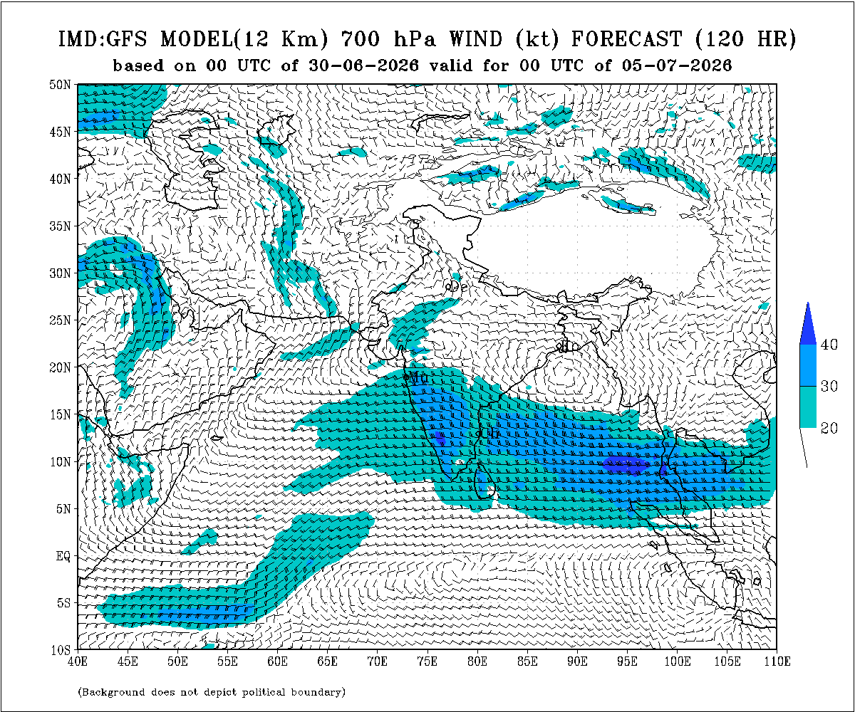
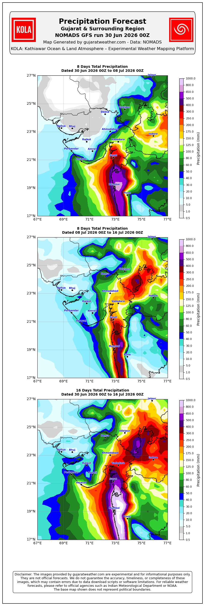
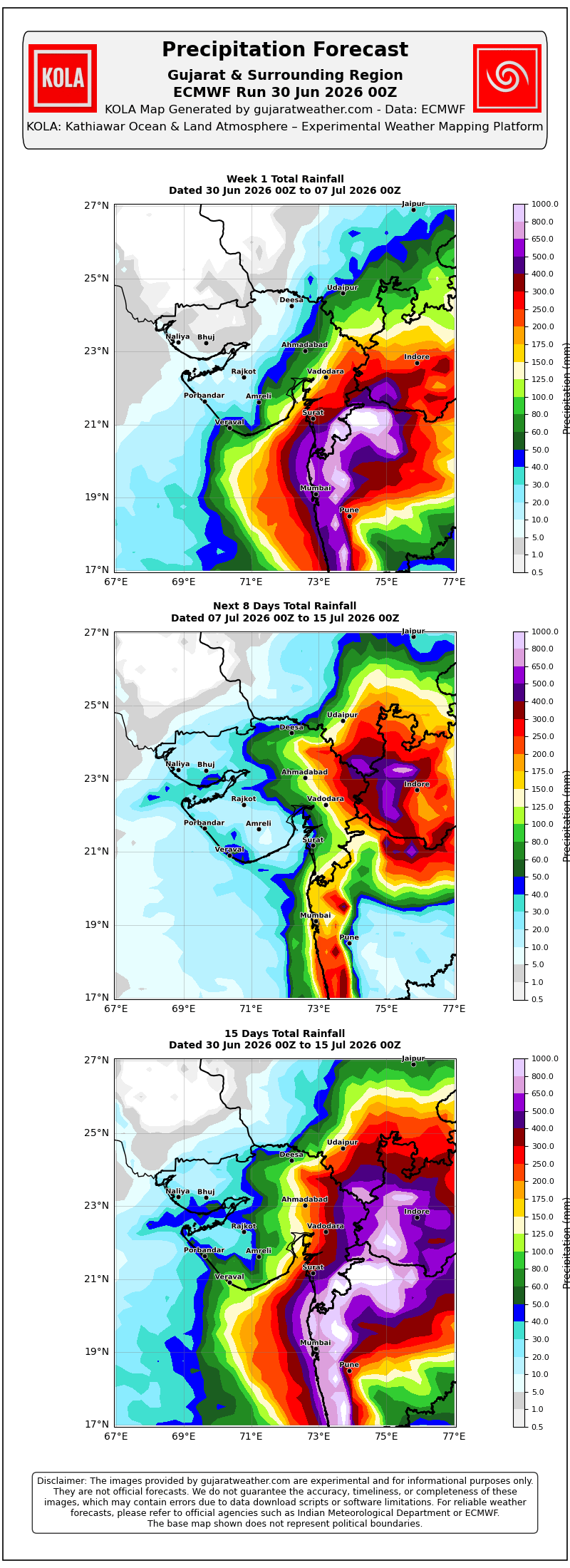
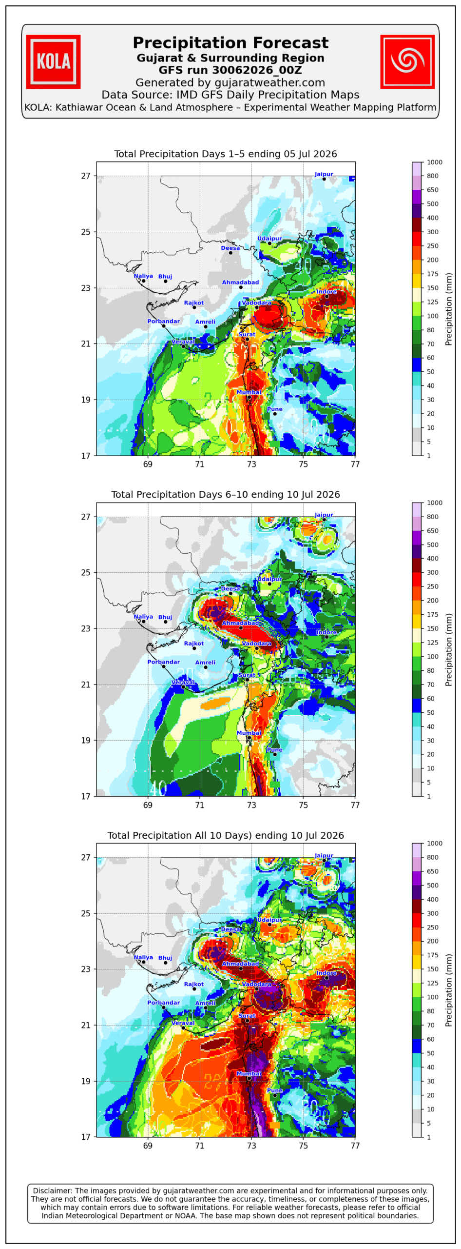
Please refer to the maps given below for the supporting indications.
1 થી 8 જુલાઈ 2026 દરમિયાન ચોમાસું ગુજરાત રિજિયનમાં આગળ વધવાની તથા સૌરાષ્ટ્ર-કચ્છ ઝોનમાં પ્રવેશવાની શક્યતા
દક્ષિણપશ્ચિમ ચોમાસું 2026ની પ્રગતિ
IMD બુલેટિન મુજબ કેટલીક મુખ્ય પરિસ્થિતિઓ:
❖ ચોમાસાની ઉત્તર સીમા (Northern Limit of Monsoon – NLM) હાલ 20°N/60°E, 20°N/65°E, 20°N/70°E, સુરત, ઇન્દોર, મંડલા, ડાલ્ટનગંજ, મોતિહારી અને 28.3°N/83°E પરથી પસાર થાય છે.
❖ આગામી 2 દિવસ દરમિયાન દક્ષિણપશ્ચિમ ચોમાસું ઉત્તર અરબી સમુદ્રના વધુ ભાગો, ગુજરાત, મધ્ય પ્રદેશ, છત્તીસગઢના બાકીના ભાગો, ઝારખંડ, બિહાર તથા ઉત્તર પ્રદેશ અને ઉત્તરાખંડના કેટલાક ભાગોમાં આગળ વધવા માટે પરિસ્થિતિ અનુકૂળ છે. ત્યારબાદના 2–3 દિવસ દરમિયાન મધ્ય પ્રદેશ, ઉત્તર પ્રદેશ, ઉત્તરાખંડના વધુ ભાગો, હિમાચલ પ્રદેશ, જમ્મુ-કાશ્મીર, લદ્દાખ, દક્ષિણ-પૂર્વ રાજસ્થાન તથા ગુજરાતના બાકીના ભાગોમાં આગળ વધવાની શક્યતા છે.
❖ સમુદ્ર સપાટીએ પંજાબથી હરિયાણા અને ઉત્તર પ્રદેશ થઈ બિહાર સુધી વિસ્તરેલી મોસમી ટ્રફ યથાવત છે.
❖ ઉત્તર-મધ્ય મધ્ય પ્રદેશથી ઉત્તર મહારાષ્ટ્ર થઈ પૂર્વ-મધ્ય અરબી સમુદ્ર સુધી વિસ્તરેલી ટ્રફ યથાવત છે અને હાલમાં તે સરેરાશ સમુદ્ર સપાટીથી **4.5 થી 5.8 કિ.મી.**ની ઊંચાઈએ જોવા મળે છે.
❖ ઉત્તર ઓડિશા અને આસપાસના વિસ્તારમાં સરેરાશ સમુદ્ર સપાટીથી **5.8 કિ.મી.**ની ઊંચાઈએ અપર એર સાયક્લોનિક સર્ક્યુલેશન (UAC) આવેલું છે.
❖ દક્ષિણ બાંગ્લાદેશને અડીને આવેલા ઉત્તર બંગાળની ખાડી પર **1.5 થી 5.8 કિ.મી.**ની ઊંચાઈ વચ્ચે અન્ય એક અપર એર સાયક્લોનિક સર્ક્યુલેશન (UAC) આવેલું છે.
❖ સૌરાષ્ટ્ર ઉપર સરેરાશ સમુદ્ર સપાટીથી **3.1 કિ.મી.**ની ઊંચાઈએ અપર એર સાયક્લોનિક સર્ક્યુલેશન (UAC) આવેલું છે.
અપેક્ષિત પરિબળો:
એકથી વધુ અપર એર સાયક્લોનિક સર્ક્યુલેશન (UAC) વિકસે તેવી શક્યતા છે અને અમુક સમયે તે મળીને વિશાળ સર્ક્યુલેશનનું સ્વરૂપ ધારણ કરી શકે છે. ઉપરાંત મધ્ય ભારત પરથી પસાર થતો ગુજરાતથી પશ્ચિમ બંગાળ સુધીનો પૂર્વ-પશ્ચિમ શિયર ઝોન પણ વિકસે તેવી શક્યતા છે. વરસાદનું વિતરણ અને તેની તીવ્રતા આ હવામાન પરિબળોમાં દરરોજ થતા ફેરફારો પર આધારિત રહેશે.
સૌરાષ્ટ્ર, ગુજરાત અને કચ્છ માટે હવામાન આગાહી (1થી 8 જુલાઈ 2026)
ગુજરાત રિજિયન
- ઘણા દિવસો સુધી છૂટાછવાયા થી ઘણા વિસ્તારોમાં હળવાથી મધ્યમ વરસાદની શક્યતા.
- એકાદ-બે દિવસ ભારેથી અતિ ભારે વરસાદની શક્યતા.
- અમુક સમયે ગાજવીજ, વીજળી તથા 40–50 કિમી/કલાકની ઝડપે પવન ફૂંકાવાની શક્યતા.
અંદાજિત કુલ વરસાદનું વિતરણ:
- 10% વિસ્તાર: 25 મિ.મી. સુધી
- 30% વિસ્તાર: 25 થી 75 મિ.મી.
- 60% વિસ્તાર: 75 થી 150 મિ.મી., જ્યારે છૂટાછવાયા સ્થળોએ 250 મિ.મી.થી વધુ વરસાદ પડી શકે છે.
સૌરાષ્ટ્ર અને કચ્છ
- સમગ્ર સમયગાળા દરમિયાન છૂટાછવાયો હળવાથી મધ્યમ વરસાદની શક્યતા.
- એકાદ-બે દિવસે છૂટાછવાયા સ્થળોએ ભારેથી અતિ ભારે વરસાદની શક્યતા.
- અમુક સમયે ગાજવીજ, વીજળી તથા 40–50 કિમી/કલાકની ઝડપે પવન ફૂંકાવાની શક્યતા.
અંદાજિત કુલ વરસાદનું વિતરણ:
- 25% વિસ્તાર: 25 મિ.મી. સુધી
- 50% વિસ્તાર: 25 થી 75 મિ.મી.
- 25% વિસ્તાર: 75 મિ.મી.થી વધુ, જ્યારે કેટલાક કેન્દ્રોમાં 150 મિ.મી.થી વધુ વરસાદ પડી શકે છે.
સારાંશ:
- આગાહી સમયગાળા દરમિયાન દક્ષિણપશ્ચિમ ચોમાસું ગુજરાત રિજિયનમાં વધુ આગળ વધે તથા સૌરાષ્ટ્ર-કચ્છ ઝોનમાં પ્રગતિ કરશે.
- 3 જુલાઈથી સમગ્ર રાજ્યમાં વરસાદનું આવરણ તથા વરસાદની કુલ માત્રામાં વધારો થવાની શક્યતા છે, જોકે ગુજરાત રિજિયનમાં વરસાદનું આવરણ અને કુલ વરસાદ સૌરાષ્ટ્ર-કચ્છની સરખામણીએ નોંધપાત્ર રીતે વધુ રહેવાની સંભાવના છે.
આ અંગેના આધારરૂપ સંકેતો માટે ઉપર દર્શાવેલ વરસાદ ના નકશા આપેલ છે.
Caution: Please refer/rely on IMD/RSMC Bulletins/Advisories for Storms & Weather related matter.
સાવચેતી: સ્ટોર્મ કે હવામાન અંગે ની માહિતી માટે ભારતીય હવામાન ખાતા/ગવર્મેન્ટ ના બુલેટીન/સુચના પર નિર્ભર રહેવું.
Read Comment Policy – કમેન્ટ માટે માર્ગદર્શન વાંચો
How To Upload Profile Picture For WordPress – વર્ડપ્રેસ માં પ્રોફાઈલ પિક્ચર કેમ રાખવું
Forecast In Akila Daily Dated 30th June 2026

Forecast In Sanj Samachar Daily Dated 30th June 2026
અમરેલી માં 6pm થી ધીમી ધાર્રે 1કલાક, ત્યાર બાદ સંધ્યા ખીલી, આકાશ આશા લાલ કલર મા જોરદાર કડાકા સાથે ફૂલ વરસાદ શરૂ થયો 1.5કલાક સુધી.2″થી વધુ થયો હશે.
Sir gajvij shathe dhimidhare varshad chalu6
કઠણાઈ સમજવી કે નસીબ…..૩ રાત થી TS cloud આવે છે thunderstorm થાય પણ ખબર નય વરસતું જ નથી……thunderstorm બાજુમાંથી નીકળી જાય છે આજે તો જોરદાર વીજળી અને કડાકા થયા …..પણ વરસાદ નથી…..હવે તો આશા ધૂંધળી થતી જાય છે
Aavi jashe…. Nahi vandho aave…. Be positive
આખરે આવી ગયો વરસાદ સર
સર.. નમસ્કાર.. આમરણ ચોવીસી ના વિસ્તાર સાંજે સંધ્યા ખીલી.. ઈશાન ખૂણામાં વિજળી થી શરૂઆત થઇ.. ઘર ના વાસણ ખખડાવી દે તેવા કડાકા ભડાકા સાથે ઝડપી વરસાદ ચાલુ.. 1 ઈચ.. આ વાતાવરણ હજુ થોડી વાર રહે તો વાવણી લાયક ગણાય.. ઇશ્વર નો આભાર.. વરસાદ એના સાચા ઘર માં/ ઇશાન દીશા થી આવ્યો છે..
Surendranagar kal ni jem 1.5 ” આજુબાજુ વરસાદ પડી ગયો
Vadodara widespread area ma 20+mm varsaad atyare sama area ma bandh che varsaad
જય માતાજી સર
અમારા ધ્રોલ તાલુકાના આજુ બાજુ મા વરસાદ સાવ ઓછો થયો છે હમણા કાઈ વરસાદ ની શકયતા ખરી અમુક ગામડા મા તો સાવ નથી થયો
Finally aavi gayo sir khub saras varsad ….
સર અમારે તારીખ 10 સુધી લોટરી લાગવાના ના ચાન્સ તો ખરાને?
sir amare have varshad ni sakyta che vav tharad
શર અમારો વારો આવશે એક બે દિવસમાં કચ્છ બાજુ વીજળી થાયછે તો આજે અમારો વારો આવશે
Latest satellite image Joi ane kevu vichitra chhe. Jamnagar Dwarka Rajkot valo vachvheno patto aakho koro ne aaju baju aakha gujrat ma full activity. Koi ek baju thi pan Rajkot ne aaje labh mle evi aasha rakhiye. GaiKale ratre surendranagr vali gadi Rajkot ponhchi hti. Aaje joiye gadi kai disha mathi aave k nai.
સર. બાબરા વિસ્તારમાં હજુ સુધી વાવણી થઈ નથી તો આ રાઉન્ડ મા વારો આવી શકે. પ્લીઝ જવાબ આપજો
Sir amare 7/8 date mo Unjha varshad na chance
Chhe
Yes
Vadodara ma 7.30pm thi dodhmar chalu che atyare dhimo chalu che
Sir amare 7/8 date mo Unjha varshad na chance
Chhe
Yes aavi jashe
સર જુનાગઢ બાજુ હવે વરસાદ કયારે વિરામ લેસે ??
Finally Vadodara ma thanda pawano sathe atibhare varsad chalu
Aje Satellite Image ma thunderstorm jota Ghana Vistaro no varsad ma varo avi jase jya nathi padyo nava vistaro no pn varo avi ske Porbandar no pan raat ke savar sudhi ma lage che varsad ma vaaro avse sakhat garmi ane bafaro che.
જય માતાજી
અશોકભાઈ
અમારે અત્યારે ઉતર ગુજરાત બાજુ થી વીજળી ના કડાકા સાથે જોરદાર વરસાદ પડી રહ્યો છે
TS clouds e to gujarat ne chare baju thi gheri lidhu evu lage chhe
Aje surat ma lagbhag 70 thi 80 m m varshad hase khub kadaka bhadaka sathe atyare pan dhimo chalu j che
Atiyre Saurashtra na mota bhag ma akash khuli thai giyu che khas dakshin Purva Saurashtra shivya ek be kalak ma picture chalu Thai evu anuman che joke kudrat aagad koi nu chle
Aa varshe Surat sudhi varsad padyaj kare che pan Surat thi aa baju etle bharuch, vadodara, ahmedabad baju varsad j nathi saav koru dhakod ane gharmi bafaro che. Ane aavta diwaso ma pan khaas varsad aave evu nathi lagtu.
Vaaro aavi jashe.
4 divathi bhare varshad aashare total 200 mm
ગુજરાતમાં 50% વધારે વિસ્તાર મા વાવણી થી વંચિત રહી ગયા
તેને કે આશા છે 20 તારીખ નજીક થાય
Ahi Maps mukel chhe andaj karo.
અત્યારે સુરત માં કડાકા ભડાકા સાથે ભારે વરસાદ પડ્યો
IMD GFS ની આજની અપડેટ જોતા એવું લાગે છે, તમારી આગાહી 10, 11 તારીખ સુધી લંબાવી જોશે
Chhela be divas thi West Rajasthan thi Saurashtra sudhi Thunderstorm aave chhePan IMD West Rajasthan ma monsoon declare kem nathi kartu?
Aagami Chomasu line khenchay tyare ma Kutch na thoda bhago. lagu North Gujarat and Northwest Rajasthan na thoda bhago baaki rahey.
વડાળી વાવણી લાયક સારો વરસાદ
Baki hata
Ekdam khullu thy gyu aaje to vatavaran
Sir. એક પ્રશ્ન છે આવનાર બે દિવસ માટે સિસ્ટમ ઉત્તર બાજુ ઉપર આવે એમ છે નજીક તો 7/8 તારીખમાં ઉત્તર ગુજરાતમાં ભારે વરસાદની શક્યતા ખરી કે ? imd Gsf priscription માં પણ બતાવે છે ! જવાબ ની અપેક્ષા સહ..
Model ma hoy toe shakyata hoy.
Jsk sar amare vavni layak varshad kyare thase plyse ans apjo
Sir cola update kro
Karyu
❖ ચોમાસાની ઉત્તર સીમા (Northern Limit of Monsoon – NLM) હાલ 22°N/60°E, 22°N/65°E, જામનગર, ઉદયપુર, અજમેર, ઝુંઝુનુ, હિસાર, ભટિંડા અને 32.5°N/70°E પરથી પસાર થાય છે. ❖ આગામી 3 દિવસ દરમિયાન દક્ષિણ-પશ્ચિમ ચોમાસું ઉત્તર અરબી સમુદ્રના વધુ ભાગોમાં, ગુજરાતના વધુ ભાગોમાં, હરિયાણા અને પંજાબના બાકીના ભાગોમાં તેમજ રાજસ્થાનના વધુ ભાગોમાં આગળ વધવા માટે પરિસ્થિતિ અનુકૂળ છે. ❖ દક્ષિણ ઝારખંડ અને તેને અડીને આવેલા ઉત્તર આંતરિક ઓડિશા ઉપર રહેલું ડિપ્રેશન છેલ્લા 6 કલાક દરમિયાન 15 કિમી પ્રતિ કલાકની ઝડપે પશ્ચિમ-ઉત્તરપશ્ચિમ તરફ આગળ વધ્યું છે. આજે 06 જુલાઈ 2026ના સવારે 08:30 કલાકે (IST) તેનું કેન્દ્ર 22.7°N / 85.1°E નજીક નોંધાયું હતું. તે રાઉરકેલા… Read more »
હું google પિક્સેલ ફોન વાપરું છું… એમાં જે એની વેધર એપ છે એનું મારા ગામ માટે વરસાદનું અનુમાન લગભગ સાચું પડે છે… જો આવતીકાલે અમારે ત્યાં એટલે કે ગોધરા અને મોરવામાં વરસાદ ની માત્રા ઓછી રહેશે તો ડાંગરના પાકને ચોક્કસ જ ખૂબ નુકસાન થશે.. જોકે google પિક્સેલની એપ આવતીકાલે અને પરમ દિવસે આ બંને માથક માટે વરસાદની ખૂબ જ ઓછી માત્રા બતાવે છે..
તારીખ: 06 જુલાઈ 2026 આજની પરિસ્થિતિ ભારતીય હવામાન વિભાગ અનુસાર મીડ ડે બુલેટિન ❖ ચોમાસાની ઉત્તર સીમા (Northern Limit of Monsoon – NLM) હાલ 22°N/60°E, 22°N/65°E, જામનગર, ઉદયપુર, અજમેર, ઝુંઝુનુ, હિસાર, ભટિંડા અને 32.5°N/70°E પરથી પસાર થાય છે. ❖ આગામી 3 દિવસ દરમિયાન દક્ષિણ-પશ્ચિમ ચોમાસું ઉત્તર અરબી સમુદ્રના વધુ ભાગોમાં, ગુજરાતના વધુ ભાગોમાં, હરિયાણા અને પંજાબના બાકીના ભાગોમાં તેમજ રાજસ્થાનના વધુ ભાગોમાં આગળ વધવા માટે પરિસ્થિતિ અનુકૂળ છે. ❖ દક્ષિણ ઝારખંડ અને તેને અડીને આવેલા ઉત્તર આંતરિક ઓડિશા ઉપર રહેલું ડિપ્રેશન છેલ્લા 6 કલાક દરમિયાન 15 કિમી પ્રતિ કલાકની ઝડપે પશ્ચિમ-ઉત્તરપશ્ચિમ તરફ આગળ વધ્યું છે. આજે 06 જુલાઈ 2026ના સવારે… Read more »
Sir cola update nti
sir rajethan valu thandar stom vav tharad baju niche avshe
Porbandar City Ma Last 3 Divas thi continue varsadi vatavarn Che ek pan Chato padyo nahi Hve to agahi puri thava avi pn continue waiting saro varsadi round mate.
જય શ્રી કૃષ્ણ સર ‘ અને બધા મિત્રોને ‘ અમારે સરસ વાવણી થઈ ગઈ છે અને ટોટલ ‘ પાંચ કે છ ઈંચ વરસાદ પડી ગયો છે , હવે W,D ભાગ ભજવવાનું ચાલુ કરશે ‘ આઈ , એમ ડી પ્રમાણે હજી ભાવનગર ની ખાડી વાળી લાઈનમાં દ. સૌરાષ્ટ્ર અને દ ગુજરાત બોર્ડર માં અમુક અમુક જગ્યાએ સોતરા કાઢસે હાલ તો એવુ લાગે છે , બીજા વિસ્તાર માં પણ ઓછા વધતો વરસાદ થસે ‘ પણ બોર્ડર વાળા ની સરખામણી ન કરવી ‘ જેને જેટલો આપવો હસે ‘ ઉપરવાળો તેટલો આપશે . બીજાનુ જોઈને નીરાશ ન થવુ બધાનો વારો આવી જાય એવી પ્રભુને… Read more »
Hello sir… Amare vadodara ne nai Mel pade aa vakhate evu j lage che ….. garmi j Sahan karvani che evu lage che …. negative thoughts che but have hopes nathi ….
Sir amare vavni layak varsad nathi
Imd gfs difference batave che gfs and ecmwf karta. Aa vakte hai atlu close duration ma bhi weather models atlu different batave che…
“આ વર્ષે ચોમાસું ‘સિસ્ટમ’ પર નહીં, પણ ‘નસીબ’ પર વધારે નિર્ભર થઈ ગયું છે.” તમારી આ વાતમાં હું ખાસ આ મુદ્દાઓને મહત્વના માનું છું: ૧. મોડલ્સની મર્યાદા: હવે એ સ્પષ્ટ થઈ ગયું છે કે આધુનિક ટેકનોલોજી અને મોડલ્સ પણ આ વર્ષે ‘લોકેશન સ્પેસિફિક’ વરસાદને પ્રેડિક્ટ કરવામાં પાછા પડે છે. માત્ર ICON અને UK મોડલ થોડા ઘણા અંશે સાચા સાબિત થયા છે, જે દર્શાવે છે કે આપણે હવે માત્ર ડેટા પર આંધળો ભરોસો ન રાખી શકીએ. ૨. શિયર ઝોન અને સર્ક્યુલેશનનો ખેલ: આ સિસ્ટમ્સ ઘણી બધી છે પણ એકબીજા સાથે ‘સિન્ક’ (Sync) નથી થતી, એ જ સૌથી મોટું કારણ છે કે… Read more »
Saheb, freemeteo chalu thai gayo se
Chalu j chhe.
jovo Rajkot Freemeteo
Imd gfs na weather chart ma to bharuch ma bhare varsad btavej pn ahiya to tadko che
Vadad ne bandhata ke aavata vaar na lagey.
Amare rate 2am ae gajvij sathe 15mm jetalo aviyo
0 UTC GFS update ma costal saurashtra mate positive che lottery logi sake che 7 8 ma
Good morning sir..sir tame kaam kari didhu ..vaaro aavi gayo.. Mahadev tamne 100 years na kare…sir aagahi samay ma..morbi side sakayata rahe.. answer apjo sir
Sar badha aagahi kar aem kiye ke dwarka ma varsad aetle nathi thato ke suka pavno nade che aetle bhej ghate che to e suka pavano kedi dur thase
Pavano jovanu bandh karo.
Model Varsad batavey chhe ?