Rainfall Quantum & Area For Saurashtra & Kutch To Decrease From Today – Gujarat Region Will See Similar Trend From Tomorrow – Update 8th July 2026
સૌરાષ્ટ્ર-કચ્છમાં આજથી વરસાદનું પ્રમાણ અને વિસ્તાર ઘટશે – ગુજરાત રિજિયનમાં આવતીકાલથી સમાન વલણ જોવા મળશે – અપડેટ 8 જુલાઈ 2026
Advance of Southwest Monsoon 2026
Some conditions as per the IMD Morning Bulletin:
- The Northern Limit of Monsoon (NLM) continues to pass through 24.5°N/65°E, Barmer, Jodhpur, Rajgarh (Churu), Bhatinda and 32.5°N/70°E.
- Conditions are favorable for further advance of the Southwest Monsoon into the remaining parts of the North Arabian Sea, Rajasthan, Haryana and Punjab, thereby covering the entire country during the next 2–3 days.
- The Well-Marked Low Pressure Area over Northeast Madhya Pradesh & adjoining Southeast Uttar Pradesh lay over Northwest Madhya Pradesh & adjoining Southwest Uttar Pradesh at 0530 IST today (8th July 2026). The associated cyclonic circulation extends up to 9.6 km above mean sea level, tilting southwards with height. It is very likely to weaken during the next 12 hours.
- The seasonal monsoon trough at mean sea level now extends from Southwest Rajasthan to Bangladesh, passing through the center of the Well-Marked Low Pressure Area over Northwest Madhya Pradesh & adjoining Southwest Uttar Pradesh, North Chhattisgarh, Jharkhand and Gangetic West Bengal.
- The off-shore trough at mean sea level from South Gujarat to Central Kerala persists.
- The upper-air trough extending from the Northeast Arabian Sea to Bangladesh, passing through the Well-Marked Low Pressure Area, North Chhattisgarh, Jharkhand and Gangetic West Bengal between 0.9 km and 7.6 km above mean sea level, also persists.
Expected Parameters
- The Monsoon Trough is expected to shift towards the foothills of the Himalayas by 10th July and remain there during the forecast period.
- Once the Southwest Monsoon covers the entire country, the Monsoon Trough will be referred to as the Axis of Monsoon.
Weather Forecast for Saurashtra, Gujarat & Kutch (8th–15th July 2026)
Gujarat Region
- Fairly Widespread rainfall with Isolated Heavy rainfall: 8th–9th July
- Isolated to Scattered light to moderate rainfall: 10th–15th July
- Thundersquall: 35–50 km/h, gusting to 60 km/h on 8th–9th JulyExpected Total Rainfall Distribution
- 60% of the area: Up to 25 mm
- 30% of the area: 25–75 mm
- 10% of the area: 75–150 mm, with isolated places exceeding 250 mm
Saurashtra
- Isolated showers/light rainfall: 8th–15th July
Expected Total Rainfall Distribution:- 90% of the area: Up to 25 mm
- 10% of the area: 25–75 mm
Kutch
- Isolated showers/light rainfall: 8th–15th July
Expected Total Rainfall Distribution:- 10% of the area: 2 to 25 mm
- 90% of the area: Less than 2 mm
Summary
The well-marked low pressure area over central India is expected to weaken today, while the monsoon trough gradually shifts northwards towards the Himalayan foothills around 10th July onwards. As a result, the widespread and heavy rainfall over Gujarat State is expected to decrease.
- Saurashtra & Kutch: Rainfall activity has already reduced from 8th July, with only isolated light showers expected during the forecast period.
- Gujarat Region: Fairly widespread to widespread rainfall with isolated heavy falls is likely to continue through 9th July, after which rainfall is expected to become isolated to scattered with lower intensity from 10th July onwards.
- Strong thundersqualls with gusty winds of 35–50 km/h, gusting to 60 km/h, are possible over Gujarat Region on 8th–9th July.
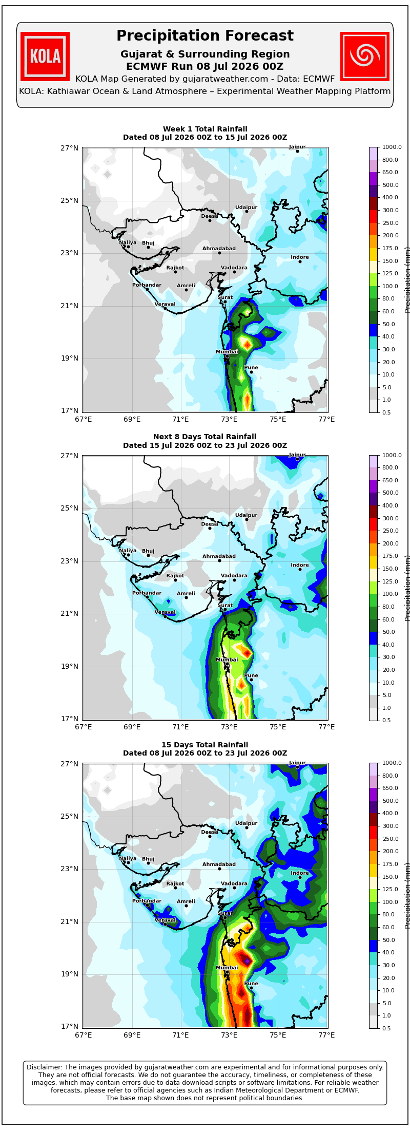
Please refer to the maps given below for the supporting indications.
સૌરાષ્ટ્ર-કચ્છમાં આજથી વરસાદનું પ્રમાણ અને વિસ્તાર ઘટશે – ગુજરાત રિજિયનમાં આવતીકાલથી સમાન વલણ જોવા મળશે – અપડેટ 8 જુલાઈ 2026
દક્ષિણપશ્ચિમ ચોમાસું 2026 ની પ્રગતિ
IMD ના સવારના બુલેટિન મુજબ કેટલીક પરિસ્થિતિઓ:
- ચોમાસાની ઉત્તર સીમા (NLM) હાલમાં 24.5°N/65°E, બારમેર, જોધપુર, રાજગઢ (ચુરુ), ભટિંડા અને 32.5°N/70°E પરથી પસાર થાય છે.
- આગામી 2–3 દિવસ દરમિયાન દક્ષિણપશ્ચિમ ચોમાસું ઉત્તર અરબી સમુદ્રના બાકીના ભાગો, રાજસ્થાન, હરિયાણા અને પંજાબના બાકીના ભાગોમાં આગળ વધવા માટે પરિસ્થિતિ અનુકૂળ છે. આ સાથે સમગ્ર દેશમાં ચોમાસું બેસી જશે.
- ઉત્તર-પૂર્વ મધ્ય પ્રદેશ અને લાગુ દક્ષિણ-પૂર્વ ઉત્તર પ્રદેશ ઉપર રહેલું સુસ્પષ્ટ લો-પ્રેશર આજે 8 જુલાઈ 2026 ના રોજ સવારે 05:30 કલાકે ઉત્તર-પશ્ચિમ મધ્ય પ્રદેશ અને લાગુ દક્ષિણ-પશ્ચિમ ઉત્તર પ્રદેશ ઉપર સ્થિત હતું. તેની સાથેનું અપર એર સાયક્લોનિક સર્ક્યુલેશન સરેરાશ સમુદ્ર સપાટીથી 9.6 કિ.મી. સુધી વિસ્તરેલું છે અને ઊંચાઈ સાથે દક્ષિણ તરફ ઝુકે છે. આગામી 12 કલાક દરમિયાન તે નબળું પડવાની સંભાવના છે.
- સરેરાશ સમુદ્ર સપાટી પરનો ચોમાસાનો ટ્રફ હવે દક્ષિણ-પશ્ચિમ રાજસ્થાનથી બાંગ્લાદેશ સુધી, ઉત્તર-પશ્ચિમ મધ્ય પ્રદેશ અને લાગુ દક્ષિણ-પશ્ચિમ ઉત્તર પ્રદેશ ઉપર આવેલા સુસ્પષ્ટ લો-પ્રેશરના કેન્દ્ર, ઉત્તર છત્તીસગઢ, ઝારખંડ અને ગંગીય પશ્ચિમ બંગાળ થઈને પસાર થાય છે.
- દક્ષિણ ગુજરાતથી મધ્ય કેરળ સુધીનો ઓફ-શોર ટ્રફ યથાવત છે.
- ઉત્તર-પૂર્વ અરબી સમુદ્રથી બાંગ્લાદેશ સુધીનો અપર એર ટ્રફ, જે સુસ્પષ્ટ લો-પ્રેશર વિસ્તાર, ઉત્તર છત્તીસગઢ, ઝારખંડ અને ગંગીય પશ્ચિમ બંગાળમાંથી પસાર થાય છે તથા **0.9 થી 7.6 કિ.મી.**ની ઊંચાઈ વચ્ચે આવેલો છે, તે પણ યથાવત છે.
અપેક્ષિત પરિબળો
- 10 જુલાઈ સુધીમાં ચોમાસાનો ટ્રફ હિમાલયની તળેટી તરફ ખસે તેવી શક્યતા છે અને આગાહી સમયગાળા દરમિયાન ત્યાં જ રહેવાની સંભાવના છે.
- સમગ્ર દેશમાં દક્ષિણપશ્ચિમ ચોમાસું બેસી ગયા પછી Monsoon Trough ને Axis of Monsoon તરીકે ઓળખવામાં આવશે.
સૌરાષ્ટ્ર, ગુજરાત અને કચ્છ માટે હવામાન આગાહી (8–15 જુલાઈ 2026)
ગુજરાત રિજિયન:
- ઠીક ઠીક વ્યાપક વિસ્તારોમાં હળવાથી મધ્યમ વરસાદ, સાથે છૂટાછવાયા સ્થળોએ ભારે વરસાદ: 8–9 જુલાઈ
- આઇસોલેટેડ થી છુટા છવાયા વિસ્તારો માં હળવાથી મધ્યમ વરસાદ: 10–15 જુલાઈ
- ગાજ વીજ પવન (35–50 કિમી/કલાક, ઝાપટા સાથે 60 કિમી/કલાક સુધી): 8–9 જુલાઈ
અપેક્ષિત કુલ વરસાદનું વિતરણ:
- 60% વિસ્તાર: 25 મિમી સુધી
- 30% વિસ્તાર: 25–75 મિમી
- 10% વિસ્તાર: 75–150 મિમી, જ્યારે અમુક સ્થળોએ 250 મિમીથી વધુ વરસાદ પડી શકે.
સૌરાષ્ટ્ર:
- છૂટાછવાયા ઝાપટાં / હળવો વરસાદ: 8–15 જુલાઈ
અપેક્ષિત કુલ વરસાદનું વિતરણ:
- 90% વિસ્તાર: 25 મિમી સુધી
- 10% વિસ્તાર: 25–75 મિમી
કચ્છ:
- છૂટાછવાયા ઝાપટાં / હળવો વરસાદ: 8થી 15 જુલાઈ
અપેક્ષિત કુલ વરસાદનું વિતરણ:
- 30% વિસ્તાર: 2 થી 25 મિમી
- 70% વિસ્તાર: 2 મિમીથી ઓછો
સારાંશ
મધ્ય ભારત ઉપર આવેલું સુસ્પષ્ટ લો-પ્રેશર આજે નબળું પડવાની સંભાવના છે, જ્યારે ચોમાસાનો ટ્રફ ધીમે ધીમે 10 જુલાઈ આસપાસથી હિમાલયની તળેટી તરફ ખસે તેવી શક્યતા છે. તેના પરિણામે ગુજરાત રાજ્યમાં વ્યાપક અને ભારે વરસાદનું પ્રમાણ ધીમે ધીમે ઘટવાની શક્યતા છે.
- સૌરાષ્ટ્ર અને કચ્છ: 8 જુલાઈથી વરસાદની પ્રવૃત્તિમાં ઘટાડો નોંધાયો છે અને આગાહી સમયગાળા દરમિયાન માત્ર છૂટાછવાયા હળવા વરસાદ અથવા ઝાપટાંની શક્યતા છે.
- ગુજરાત રિજિયન: 9 જુલાઈ સુધી ઘણા વિસ્તારોમાં વરસાદ સાથે છૂટાછવાયા ભારે વરસાદની શક્યતા રહેશે. ત્યારબાદ 10 જુલાઈથી વરસાદનું પ્રમાણ અને વિસ્તાર બંને ઘટશે અને છૂટાછવાયા થી થોડા વિસ્તારોમાં હળવાથી મધ્યમ વરસાદની શક્યતા રહેશે.
- 8–9 જુલાઈ દરમિયાન ગુજરાત રિજિયનમાં 35–50 કિમી/કલાકની ઝડપે, ઝાપટા સાથે 60 કિમી/કલાક સુધીના પવન સાથે ગાજ વીજ ની શક્યતા છે.
આ અંગેના આધારરૂપ સંકેતો માટે ઉપર દર્શાવેલ વરસાદ ના નકશા આપેલ છે.
Caution: Please refer/rely on IMD/RSMC Bulletins/Advisories for Storms & Weather related matter.
સાવચેતી: સ્ટોર્મ કે હવામાન અંગે ની માહિતી માટે ભારતીય હવામાન ખાતા/ગવર્મેન્ટ ના બુલેટીન/સુચના પર નિર્ભર રહેવું.
Read Comment Policy – કમેન્ટ માટે માર્ગદર્શન વાંચો
How To Upload Profile Picture For WordPress – વર્ડપ્રેસ માં પ્રોફાઈલ પિક્ચર કેમ રાખવું
Forecast In Akila Daily Dated 8th July 2026

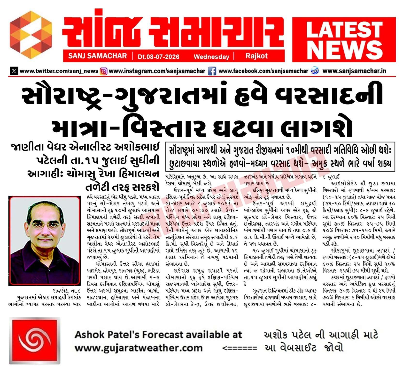
Forecast In Sanj Samachar Daily Dated 8th July 2026
Sar 15 tarikh thi bhej vdhe amari baju to sar aavi sake vrsad ?
આ મિત્રો ની માહિતી માટે મુકેલ છે
IMD Mujab CHomasu thodu vahelu chalu thaay chhe havey.
Aajthi varsad no lambo viraam
Ketlo lambo viram raheshe amare haju vavni nathi thy lodhika baju
Thanks for New update
તા. 09 જુલાઈ 2026 આજની પરિસ્થિતિ ભારતીય હવામાન વિભાગ અનુસાર મીડ ડે બુલેટિન નૈઋત્યનું ચોમાસું આજે 09 જુલાઈ, 2026ના રોજ ઉત્તર અરબી સમુદ્રના બાકીના ભાગો, રાજસ્થાન, હરિયાણા અને પંજાબના બાકીના ભાગોમાં આગળ વધ્યું છે. આ સાથે આજે સમગ્ર ભારત દેશમાં નૈઋત્યનું ચોમાસું પૂર્ણ રીતે છવાઈ ગયું છે. સામાન્ય તારીખ 08 જુલાઈની સરખામણીએ આ વર્ષે ચોમાસું 1 દિવસ મોડું સમગ્ર દેશમાં પહોંચ્યું છે. ઉત્તર-પશ્ચિમ મધ્ય પ્રદેશ અને લાગુ દક્ષિણ-પશ્ચિમ ઉત્તર પ્રદેશ પરનુ વેલ માર્કડ લો પ્રેશર આજે સવારે 08:30 કલાકે દક્ષિણ-પશ્ચિમ ઉત્તર પ્રદેશ અને આસપાસના વિસ્તારો પર સ્થિત છે. તેની સાથે સંકળાયેલ સાયક્લોનિક સર્ક્યુલેશન સરેરાશ સમુદ્ર સપાટીથી 7.6 કિ.મી. સુધી વિસ્તરેલું… Read more »
સર.
ડાયકૃન બાવિ વાવાઝડા ની અસર ચોમાસા ઉપર પડે ખરી ?
Satellite ma jovo. Kai maal (Vadada) te baju jaay chhe? Pavan te baaju jaay chhe?
Bay of Bengal mathi bhej upadey chhe ?
Evu khas kai dekhatu nathi
Finally Chomasu aakha Desh ma aaje besi gyu. but aakha desh ma varsad nathi padyo.
સર મેં તમને તારીખ 6/7/26 ના રોજ પુછ્યું તું ફિલીપીન્સ ના વાવાઝોડા બાબત આજે એનો જવાબ સ્કાય મેટ વારા એ વી એમ જી પી શર્મા દ્વારા યુ ટ્યુબ પર વિડિયો મુકેલ છે તેણે એવું કહ્યું કે સુપર વાવાઝોડું બાવી ભારત ના ચોમાસા ને અસર કરે
Sari ritey ke kharab ritey?
સર આમા 90 ટકા વિસ્તાર છે તેમાં છૂટો સવાયો વરસાદ સમજવો કે 90ટકા માં બધે સમજવો
Total 90 vistar maate badhe.
Badhe shu te samjo?
25 mm sudhi etle?
Thanks for update
સૌરાષ્ટ્ર અને કચ્છમાં વરસાદના પ્રથમ રાઉન્ડ બાદ કુલ વરસાદનું વિતરણ. (GSDMA ના ડેટા પ્રમાણે)
Saras mahiti che bhai
Thankyou aavi mahiti badal
Thank you sir for New Update
sir amara taluka ma che amare ocho che
15 divas na mep pramane sarvtik varshad nathi thodo gano thase pan te pan jya aaraund ma varshad pado tyaj pad she jamnagar rajkot dwarka ane katch mate mushkeli che
sir amra upar vadalo che to varshad kem nathi
Sauthi vadhu Varsad Deodar ma chhe tamara Jilla ma
117 mm
Thanks sir for new update apava badal amare to a raund ma lotari lagi gay hati 1 divash ma 6 thi 7 inch jevo varsad padi gayo tame kidhu tu am amuk jagya a 150mm padse ama ame avi gya tamari sachot agahi Amare kheti mate khub upyogi thayse tamaro khub khub abhar sir
15tarikhh pashi rah jova ni su thay se
Sir gaya round maa Amare 2 thi 6 Julay sudhi maa katake katake total 135 mm varsad thayo
સર,map જોતા આહક એ છે approx સુરેન્દ્રનગર ઉપર કલર જ નથી બતાવતું….
પછી આગળ ના દિવસો માં વાતાવરણ માં જે કઈ ફેરફાર થાય તે….
Thanks sir
Sir pavan ketla divas rese
Pavan bov che.
Total aagahi samay darmiyan.
Sir July month no rainfall below normal rai ske 6e?
Kai nakki na hoy.
Mumbai ne 8 divas ma 2 mahina nu aapi didhu.
30 જૂન થી 8 જુલાઈ
લગભગ 45 ઇંચ
જય સીયારામ
Sir ji, Rajkot , Jamnagar, surendranagar, morbi, Dev bhumi Dwarka, district mota bhage Varsad nathi and Vavni latak pan nathi. Aashaa AMAR Che, aavya divsoma badhe khub saro varsad thay tevi ishwar ne pratharna che.
25% ne 25 mm sudhi ni vaat hati aagali update ma.
Ahi aaje comment ma te mukel chhe.
Sir Aa round ma varsad ma evu che Jya pdyo tya Atibhare pdyo etle 20 inch 30 inch pdyo E j dekhai che jya Pn 1 thi 3 inch thyo e nathi dekhano ane saav nathi pdyo eni vaat judi j che ek aa vastu same avi che. State motu hoi etle Badhu j badha na fever nthi thatu Porbandar ma pn avu j che Loko ne em j lage che 1.5 inch jevo varsad pdyo pn Porbandar ma varsad j nathi pdyo Mangrol ma 40 inch pdyo evu j udaharn ape apde kem na pdyo Hju chomasu chalu che… Read more »
Aagali update 1-8 July maate hati
te aa pramaney hati:
સૌરાષ્ટ્ર અને કચ્છ
સમગ્ર સમયગાળા દરમિયાન છૂટાછવાયો હળવાથી મધ્યમ વરસાદની શક્યતા.
એકાદ-બે દિવસે છૂટાછવાયા સ્થળોએ ભારેથી અતિ ભારે વરસાદની શક્યતા.
અમુક સમયે ગાજવીજ, વીજળી તથા 40–50 કિમી/કલાકની ઝડપે પવન ફૂંકાવાની શક્યતા.
અંદાજિત કુલ વરસાદનું વિતરણ:
25% વિસ્તાર: 25 મિ.મી. સુધી
50% વિસ્તાર: 25 થી 75 મિ.મી.
25% વિસ્તાર: 75 મિ.મી.થી વધુ, જ્યારે કેટલાક કેન્દ્રોમાં 150 મિ.મી.થી વધુ વરસાદ પડી શકે છે.
Yes right sir Perfect j htu tmaru anuman.
એકદમ સચોટ હતી આપની આગાહી સર,,અમારે 170mm આગાહી સમય દરમ્યાન કટકે કટકે કોઈ નુકશાની વગર,અને અમે બોર્ડર મા આવીએ અમરેલી જિલ્લા ની રાજકોટ જિલ્લો અને જૂનાગઢ જિલ્લો બન્ને ની બોર્ડર,,
Thanks sir new update and sir jamnagar jilla ne Haji ketlik raah jovi padse varsad mate
મોરબી જિલ્લા મા છૂટા છવાયા વિસ્તાર બાદ કરતા વાવણી લાયક વરસાદ નથી…… માટે આ વર્ષ ખેડૂતો માટે અઘરું છે
Thank you sir
Aa update ma varsad mate kya paribal hase k japta svarupe hase ?
સર આ ગોતરુ એંધાણ બતાવો ને અમારે હજી લાલપુર તાલુકામાં વાવણી નથી થઈ
Aagotaru maate 2 week na Map aapel chhe update ma.
Thanks for new update sir
2019 ma chomasu Modu htu.19/7/2019 na roj chomasu sthapit thyu htu.july aatma varsad thyo hto.ogast ma Vavni Thai hti.amara eriya ni vat che.evi j pristithi che aje sav koru che Pavan fukay che.tyre tumari apdate ma agotru endhan Mikel htu Ema jordar varsad hto.
Tenks
મારા જિલ્લા પંચમહાલ માટે આ રાઉન્ડ માં વરસાદ ધાર્યા કરતા ખૂબ ઓછો થયો છે… જેને વધારે પાણી ની જરૂર પડશે તેવા પાકોને ચોક્કસ તકલીફ પડશે
Forecast
=== Panch Mahals ===
=== Rainfall aggregates for Panch Mahals (08072026_00Z) ===
Coverage
100% of district area
Total Rainfall
Days 1 – 5 total: 55 mm
Days 6 – 10 total: 5 mm
Days 1 – 10 total: 60 mm
Rainfall distribution (1 – 10 days):
Dry (<2 mm): 0%
(2 - 25 mm): 21%
(25 - 75 mm): 56%
(75 - 150 mm): 23%
સાહેબ અત્યારે તો વરસાદના ડિસ્ટ્રિબ્યુશન ચાર્ટમાં જોઈએ તો પંચમહાલને 41% એક્સેસ બતાવે છે પરંતુ હકીકતમાં જે માવઠું થયેલ હતું જુનની શરૂઆતમાં તેને આ વરસાદની માત્રામાં ગણી લીધેલ છે.. આઈ એમ ડી એ આ યોગ્ય કર્યું છે કે નહીં તે તો આપણે જ નક્કી કરવાનું
Panchmahal ma 42% excess varsad chhe
IMD Rainfall Departure map pramane
સાહેબ એના માટે મારી ઉપર ની કોમેન્ટ માં જણાવ્યું છે તે પ્રમાણે લગભગ 100 mm જેવો વરસાદ ભારત માં ચોમાસુ આગમન પેહલારનો છે… શું તે ચોમાસુ વરસાદ ની માત્રા માં ગણી શકાય?
1st June pahela Kerala ma Chomasu besey chhe tyare Varsad 1st June thi ganay chhe. Agad na Varsad ne nahi. (31st May no Varsad 1st June Savare aavey te June ma ganey chhe)
Aa confirm karvi joiye.
Thanks sir for new apdet
આભાર સર
તારીખ 8 જુલાઈ 2026 આજની પરિસ્થિતિ ભારતીય હવામાન વિભાગ અનુસાર મીડ ડે બુલેટિન નૈઋત્યના ચોમાસાની ઉત્તર સીમા (NLM): નૈઋત્યના ચોમાસાની ઉત્તર સીમા હાલ 24.5°N/65°E, બારમેર, જોધપુર, રાજગઢ (ચુરુ), ભટિંડા અને 32.5°N/70°E પરથી પસાર થાય છે. આગામી 2 થી 3 દિવસ દરમિયાન ઉત્તર અરબી સમુદ્રના બાકીના ભાગો, રાજસ્થાન, હરિયાણા અને પંજાબના બાકીના વિસ્તારોમાં ચોમાસું આગળ વધવા માટે પરિસ્થિતિ અનુકૂળ છે. ત્યારબાદ સમગ્ર દેશમાં નૈઋત્યનું ચોમાસું સ્થાપિત થઈ જશે. વેલ માર્ક્ડ લો પ્રેશર: ઉત્તર-પશ્ચિમ મધ્ય પ્રદેશ અને તેને અડીને આવેલા દક્ષિણ-પશ્ચિમ ઉત્તર પ્રદેશ ઉપર આવેલું વેલ માર્ક્ડ લો પ્રેશર આજે સવારે 08:30 કલાકે પણ યથાવત્ છે. તેની સાથે જોડાયેલ અપર એર સાયક્લોનિક… Read more »
જય.માતાજી.સર.આભાર
આભાર આભાર સર
Thanks sir new update
Tomagali log verayati chhe biyaran na temanu tel nikali lai gharma vaperava thai je ariya ma pani ni sagavad nathi…….
Thanks for apdet
Sir thx new update
Thanks for updates
તો મોરબી જિલા માં હવે sakiyta ખરી કે માંડી વળવાનું કેમ કે અહીં 90% માં વાવની નથી તો ક્યારે થશે
જય માતાજી
અશોકભાઈ….આભાર
Jay shree Krishna
Thank you sir for New apdet
Saheb agotaru aendhan chhe kai??
2 athvadiya na map aapel cheh.
Jamnagar, Dwarka, Kutch- Himat rakhvani 6. aa divso pn vay jase..
Sir to amare porbandar baju na barda vishtar ma vavni layak varshad ni have jaji vat jovi padse aa ravund ma khali be japtaj aavya sir haveto hari kare te khari
Daily service zaapta chalu raheshe
Kheduto ne zapta thi bhegu thay em nathi
Hash…varap ni jarur hati sir..!
Amare varsad ni full jarur chhe
Sars
Matlab aa varshe Jamnagar ane ajubju vistar ma varash nablu taka.
Matthu.