Current Weather Conditions on 8th July 2015 @ 8.30 pm.
A Low pressure area has developed over North Bay of Bengal & adjoining coastal areas of Bangladesh & West Bengal. Associated upper air cyclonic circulation extends upto 5.8 km above mean sea level.
The axis of monsoon trough at mean sea level passes through Ganganagar, Hissar, Agra, Allahabad, Gaya, Bankura, centre of low pressure area over north Bay of Bengal & adjoining coastal areas of Bangladesh & West Bengal and thence southeastward to northeast Bay of Bengal extending up to 3.1 km above mean sea level.
Google Earth Map Showing Axis of Monsoon Trough on 8th July 2015
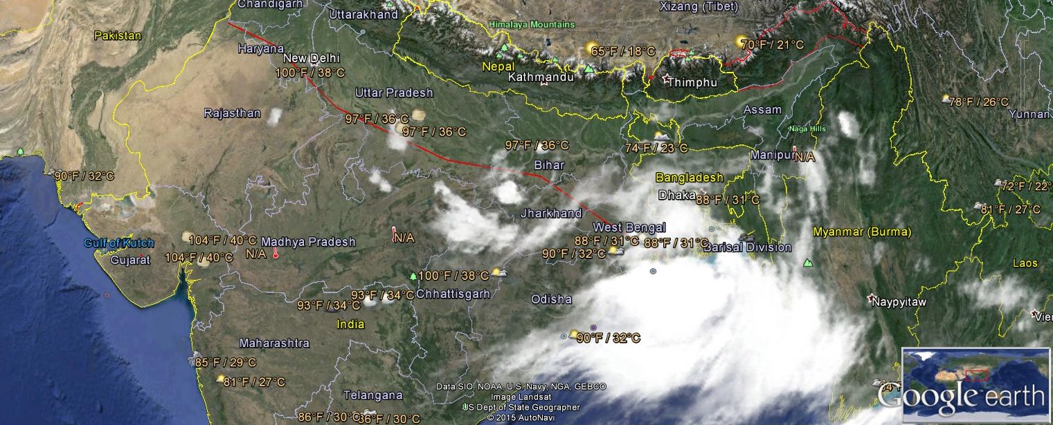
The western disturbance as an upper air cyclonic circulation over Jammu & Kashmir & neighbourhood extending upto 3.1 km above mean sea level persists.
The upper air cyclonic circulation over northwest Rajasthan & neighbourhood extending upto 3.1 km above mean sea level persists.
The other Western Disturbance as an upper air cyclonic circulation over Afghanistan & neighborhood extending up to mid tropospheric level persists.
The track of the Low Pressure System will depend up on the cumulative effects of Axis of Monsoon and the interaction with the fresh Western Disturbance over Afghanistan & neighborhood and its timing.
Forecast: 8th July to 11th July 2015
Saurashtra, Kutch & Gujarat:
Scattered showers over some places as shown in the maps above, during 8th to 11th July on most days. The indicated precipitation areas may vary.
સૌરાષ્ટ્ર ગુજરાત અને કચ્છ: છુટા છવાયા ઝાપટા તારીખ 8 જૂલાય થી 11 જૂલાય
સૂચના: આગાહી આપેલ છે તેના થી આગળ ના સમય માટે કઈ સાવલ ના કરવા. જેમ જેમ આગળ નું ચિત્ર સ્પષ્ટ થશે તેમ તેમ અપડેટ થશે. 25 જૂન 2015 થી કમેન્ટ ના જવાબ દિવસ માં એક કે બે વાર એક સાથે આપવામાં આવશે.
Weather Forecast In Akila Daily Dated 7th July 2015
Weather Forecast In Sanj Samachar Daily Dated 7th July 2015
Scroll Up