Current Weather Conditions on 3rd July 2015 @ 7.00 pm.
The feeble off-shore trough at mean sea level runs from Karnataka to Kerala coast.
The Western end of Axis of Monsoon trough passes close to the foot hills of Himalayas at mean sea level and the Eastern end passes through Bareilly, Gorakhpur, Bhagalpur, Kolkata and thence South Eastwards to East Central Bay Of Bengal.
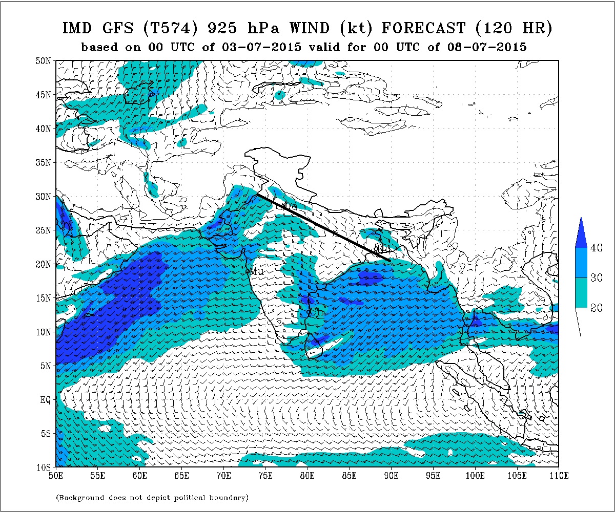
The Axis of Monsoon trough has been shown in 925 hPa IMD Map with a black line for two different days. The first map shows Axis along the foot hills of Himalayas and in the second map the Axis has tracked back half way towards its normal position. Normally the Axis of Monsoon trough passes through Barmer Rajasthan, M.P. Chhatishgarh, Odisha and thence towards the Central Bay of Bengal. Winds to the South of the Axis are Westerly and winds to the North of the Axis are Easterly.
There is a North South trough from Sub-Himalayan West Bengal & Sikkim to Northwest Bay Of Bengal across Gangetic West Bengal between 1.5 km to 3.6 km above mean sea level.
Axis Of Monsoon Trough (Black Line) Valid 00 UTC 4th July 2015 (3rd July )
Axis Of Monsoon Trough (Black Line) Valid 00 UTC 8th July 2015 (7th July )
ચોમાસું ધરી ની દક્ષીણે પવનો પશ્ચિમી હોઈ અને ઉત્તરે પૂરવાઈ (પૂર્વ તરફથી ) હોઈ. ટૂક માં આ બંને પવનો સામ સામા જ્યાં થતા હોઈ તે લાઈન ને ચોમાસું ધરી કહે. સામ સામા પવનો ને હિસાબે ત્યાં વાદળો અને વરસાદ નું પ્રમાણ વધુ હોઈ.
પહેલા નકશા માં ધરી હિમાલય બાજુ સરકી ગઈ છે. કાળી લીટી દોરેલ છે.
બીજા નકશા માં તે થોડી પરત ફરી છે. કાળી લીટી દોરેલ છે. જેમાં ધરી થી ઊત્તર માં પવનો પૂર્વ બાજુ ના જોઈ શકાય છે.
ચોમાસું ધરી ની નોર્મલ પોસીસન માં તે બારમેર રાજસ્થાન થી એમ.પી., છતીશગઢ અને ઓડીશા થઇ ને બંગાળ ની ખાડી સુધી જતી હોઈ છે.
Forecast: 4th July to 8th July 2015
COLA/IGES Forecast Precipitation Map Valid 00 UTC 7th July 2015 (6th July)
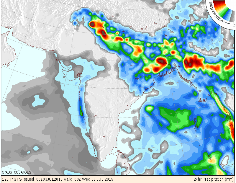
COLA/IGES Forecast Precipitation Map Valid 00 UTC 8th July 2015 (7th July)
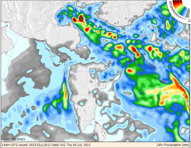
COLA/IGES Forecast Precipitation Map Valid 00 UTC 9th July 2015 (8th July)
An Upper Air Cyclonic Circulation is expected to form over West Bengal and adjoining North Bay Of Bengal around 6th July.
Saurashtra, Kutch & Gujarat:
Axis of Monsoon trough is along the foot hills of Himalaya and is expected to be in similar position for next few days. Conditions expected to improve from 6th/7th July. Scattered showers over some places as shown in the maps above, during 6th to 8th July. The indicated precipitation areas may vary.
સૌરાષ્ટ્ર ગુજરાત અને કચ્છ: છુટા છવાયા ઝાપટા તારીખ 6 જૂલાય થી 8 જૂલાય
સૂચના: આગાહી આપેલ છે તેના થી આગળ ના સમય માટે કઈ સાવલ ના કરવા. જેમ જેમ આગળ નું ચિત્ર સ્પષ્ટ થશે તેમ તેમ અપડેટ થશે. 25 જૂન 2015 થી કમેન્ટ ના જવાબ દિવસ માં એક કે બે વાર એક સાથે આપવામાં આવશે.
Weather Forecast In Akila Daily Dated 3rd July 2015
Weather Forecast In Sanj Samachar Daily Dated 3rd July 2015