Current Weather Conditions on 26th July 2015 @ 7.00 pm.
Under the influence of UAC over Madhya Pradesh a Low Pressure had formed on 25th July and strengthened further to a Well Marked Low Pressure area and is now over East Rajasthan & neighborhood. Associated upper air cyclonic circulation extends upto 5.8 km above mean sea level. It may concentrate into a depression during next 24 hours.
Under the influence of UAC over the Bay of Bengal a Low Pressure had formed yesterday. As per IMD the System is a Depression over northeast Bay of Bengal and adjoining coastal areas of Bangladesh & West Bengal remained practically stationary and lay centred at 1430 hours IST of today over the same area near Lat. 22.0°N and Long. 90.8°E, about 60 km southeast of Patuakhali (Bangladesh). The system is likely to remain practically stationary and may concentrate into a deep depression during next 48 hours.
The Axis of Monsoon trough passes through Bikaner, Centre of Well Marked Low Pressure area over East Rajasthan & neighborhood, Sidhi, Daltonganj, Purulia and thence southeastwards to Centre of Depression over Northeast Bay of Bengal & neighborhood and extends upto 5.8 km above mean sea level.
The western disturbance as an upper air cyclonic circulation over north Pakistan and neighborhood extending upto 3.1 km above mean sea level persists.
The off-shore trough at mean sea level from Karnataka coast to Kerala coast persists
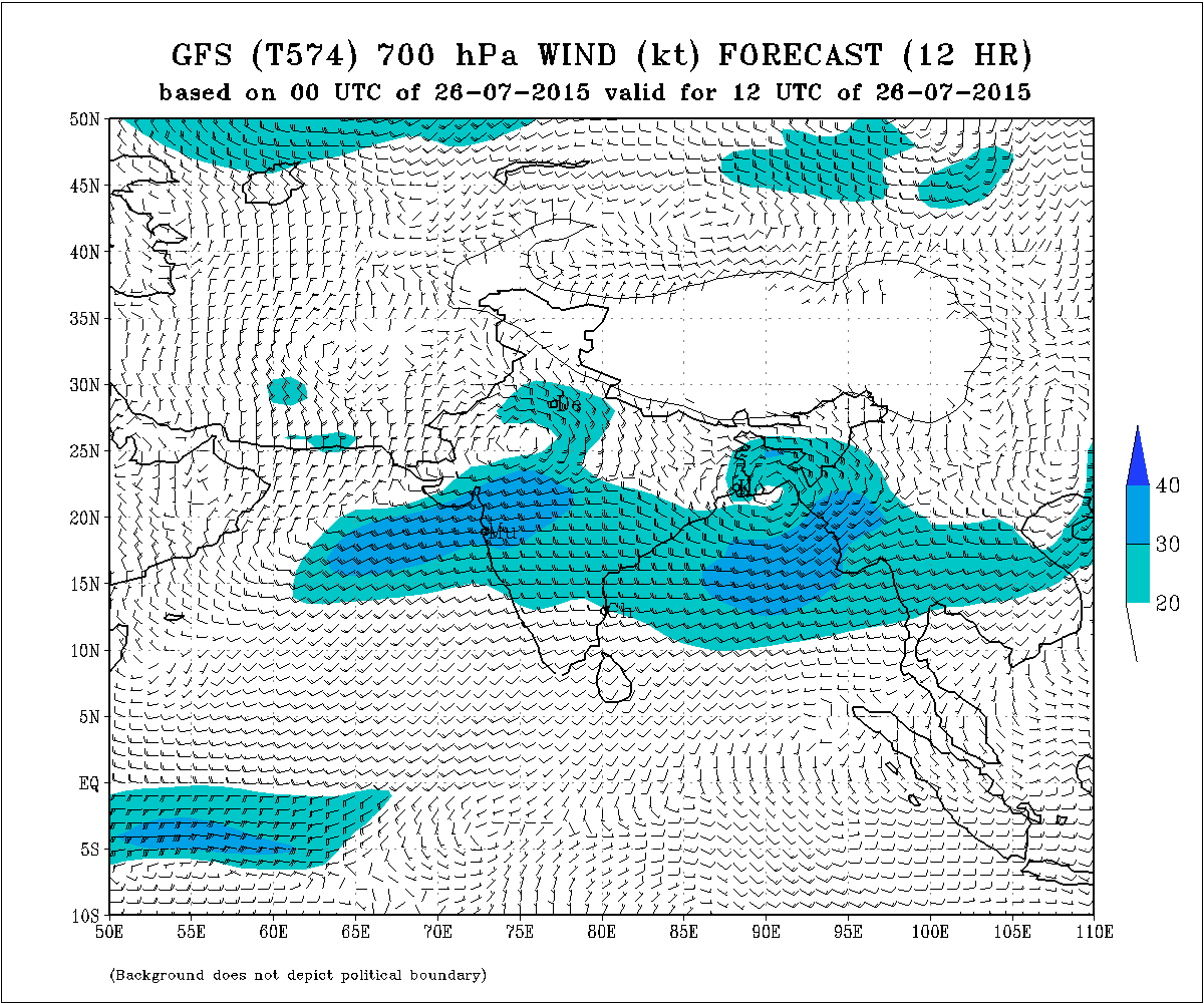
IMD GSF (T574) 700 hPa Forecast Wind Valid 1200 UTC 26th July 2015
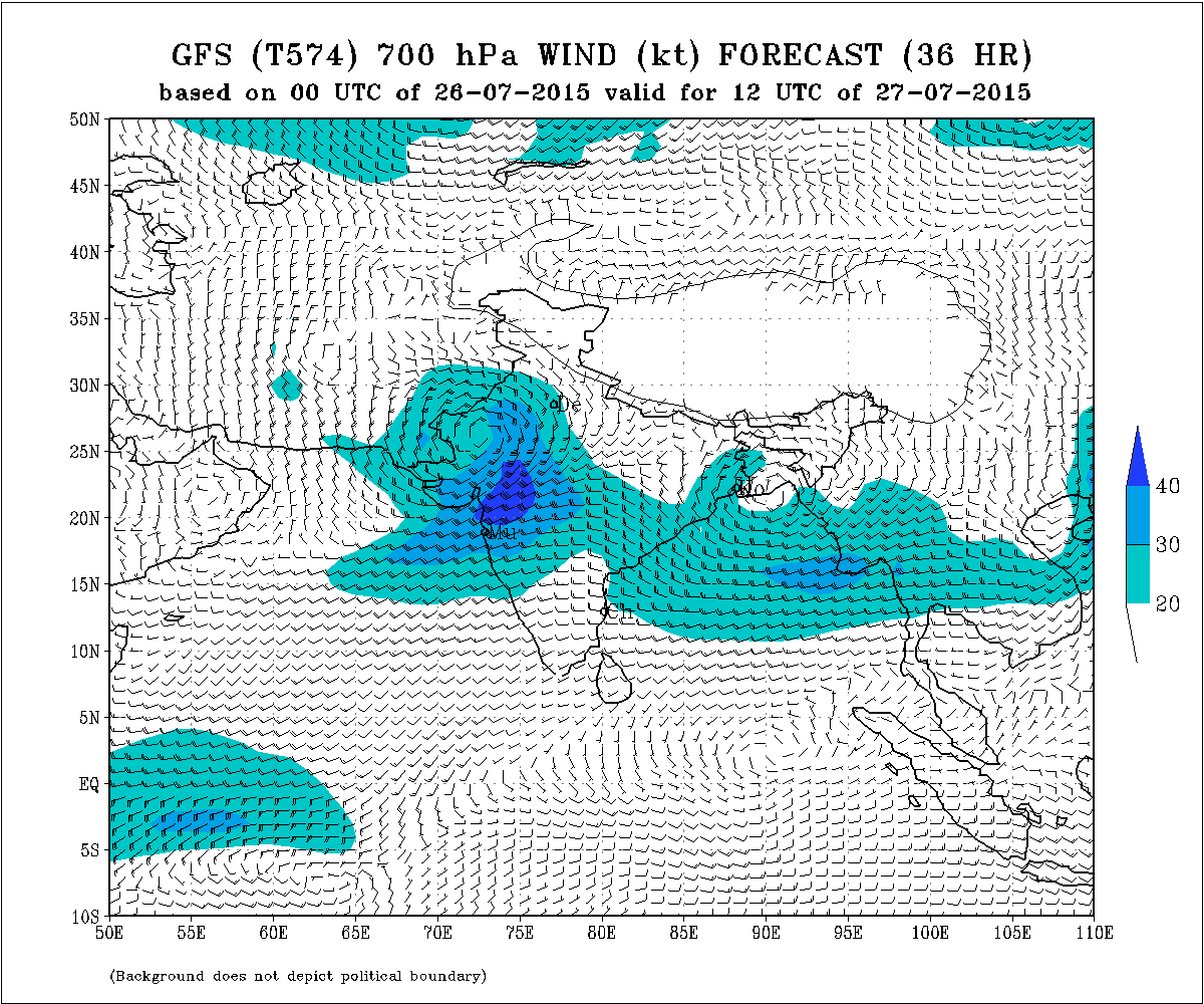
IMD GSF (T574) 700 hPa Forecast Wind Valid 1200 UTC 27th July 2015
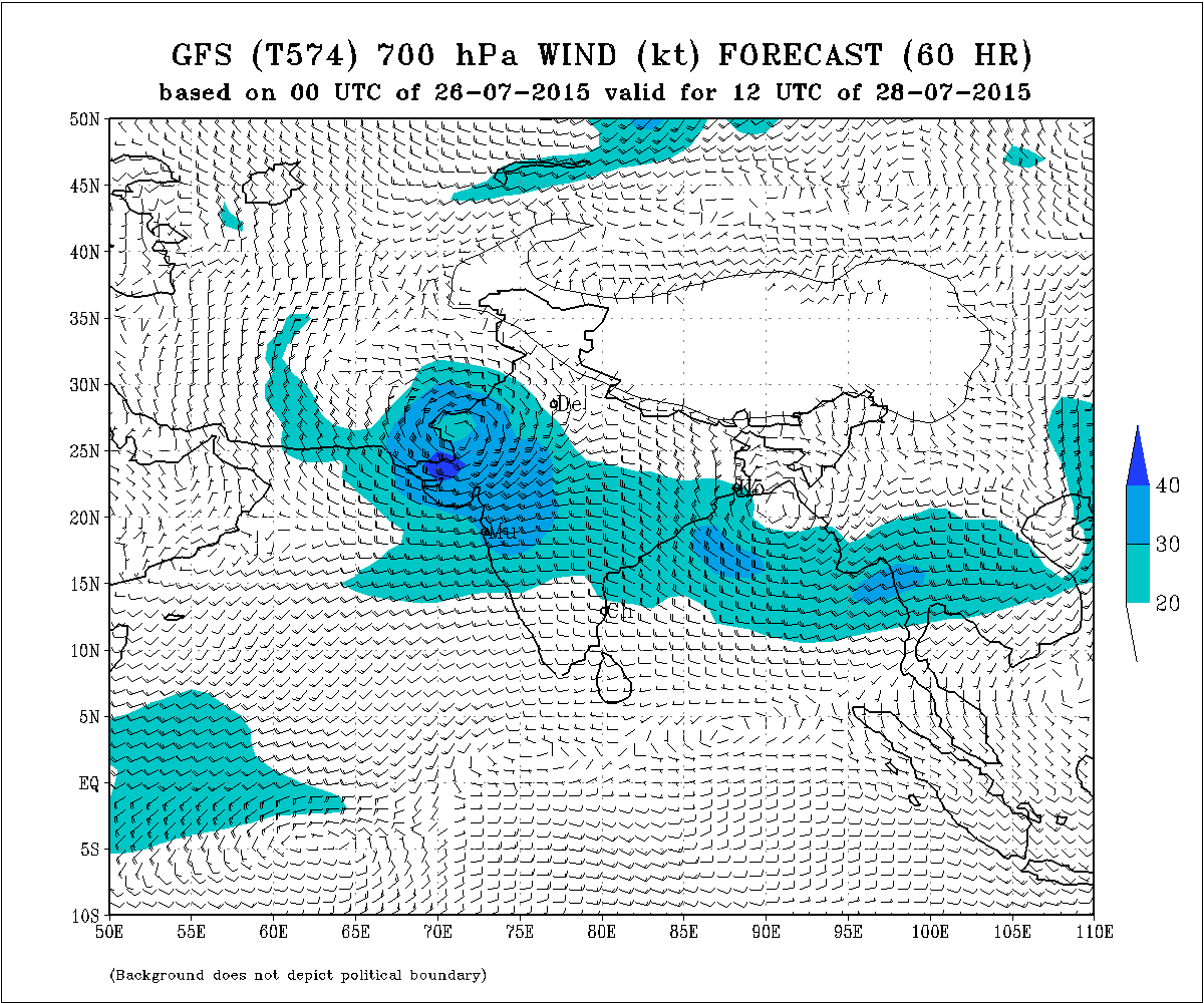
IMD GSF (T574) 700 hPa Forecast Wind Valid 00 UTC 28th July 2015
Forecast: 26th July to 29th July 2015
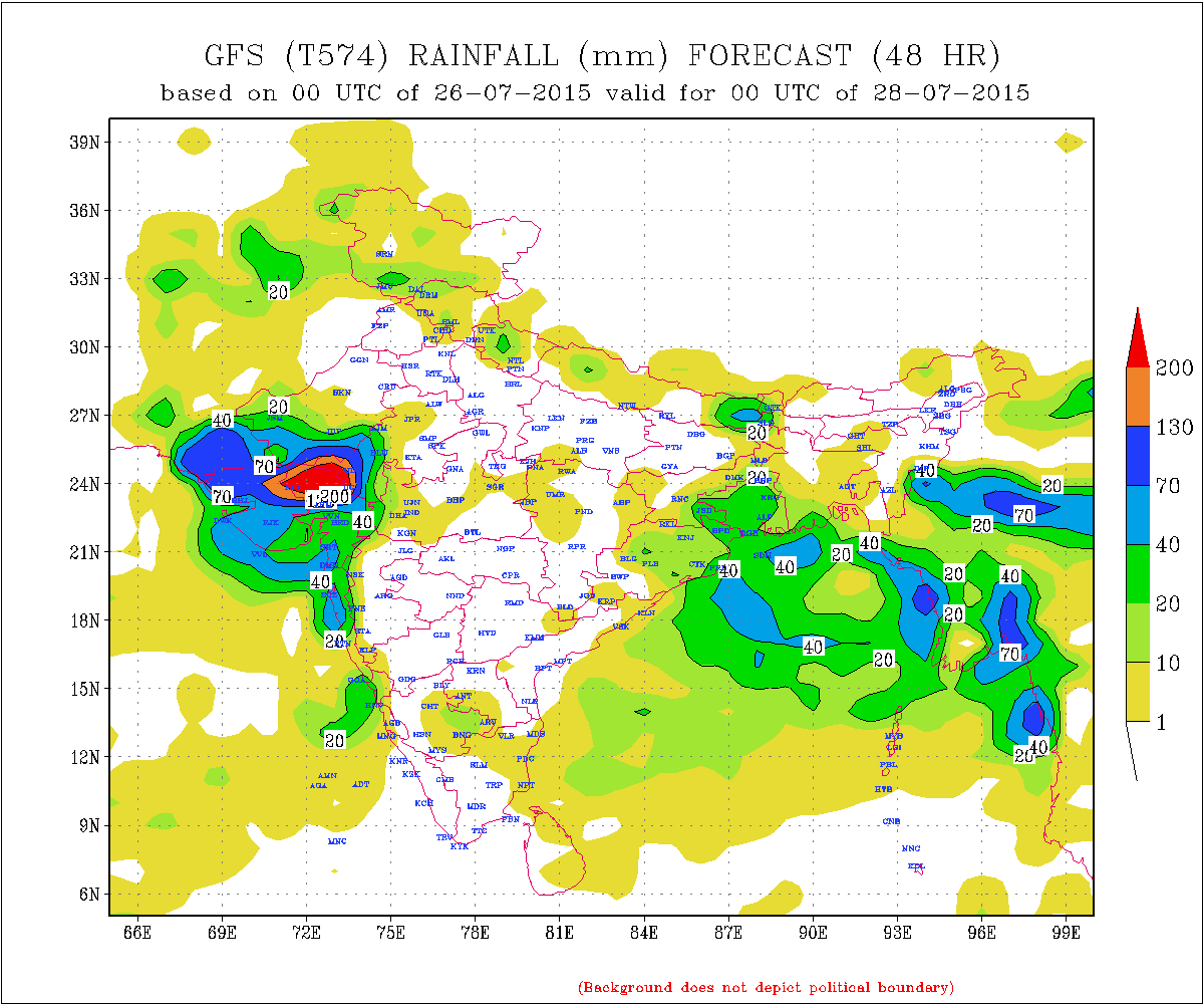
Heavy to extremely heavy rainfall expected for various parts of North Gujarat during the forecast period.
Medium to heavy to Extremely heavy rainfall expected for different parts of Kutch during the forecast period.
Medium to heavy rainfall expected for different parts of Central Gujarat during the forecast period with isolated very heavy rainfall.
Medium to heavy rainfall expected for 50% areas of Saurashtra and light to medium to heavy rainfall over rest of Saurashtra during the forecast period with isolated very heavy rainfall.
Sindh, Pakistan also expected to receive heavy rainfall with isolated heavy rainfall over some parts.
Caution: Refer/Rely on IMD/RSMC Advisories/Bulletins about heavy rain or Storms over various areas.
The quantum of rainfall over various regions of Saurashtra, Gujarat & Kutch is depicted by IMD GFS (T574) Forecast Precipitation map for all three days below.
IMD GFS (T574) Precipitation Forecast
Valid 00 UTC of 27th July 2015 ( For 26th July)

IMD GFS (T574) Precipitation Forecast
Valid 00 UTC of 28th July 2015 ( For 27th July)
IMD GFS (T574) Precipitation Forecast
Valid 00 UTC of 29th July 2015 ( For 28th July)

તારીખ 26 જૂલાઈ થી 29 જૂલાઈ :
સૌરાષ્ટ્ર ગુજરાત અને કચ્છ:
તારીખ 24 ના જણાવેલ તેમ પહેલા ઊત્તર ગુજરાત માં તેમજ મધ્ય ગુજરાત માં વરસાદ ચાલુ થયો અને પછી સૌરાષ્ટ્ર માં અને કચ્છ માં ચાલુ થયો હોઈ કે થવામાં હોઈ. જનરલ બધે ચોમાસું માહોલ છવાયેલ છે.
26 થી 29 જૂલાઈ : તારીખ 26 ના ચાલુ થતો વરસાદ નો માહોલ વધુ શક્રિય થાય અને ભારે વરસાદ પડે તેવા ઊજળા સંજોગો છે.
હાલ વેલ માર્કડ લો પ્રેસર ઊત્તર પૂર્વ રાજસ્થાન નજીક છે અને તેનું મૂકામ રાજસ્થાન ઉપર આવતા ચાર દિવસ રહેશે. સીસ્ટમ સેન્ટર હોઈ તેનાથી દક્ષીણે અને દક્ષીણ પશ્ચિમે વાદળો અને વરસાદ વધુ હોઈ. જેથી ઊતર ગુજરાત અને લાગુ વિસ્તારો ને વધુ વરસાદ થશે. આ સીસ્ટમ ને ભેજ અરબી સમુદ્ર પણ પૂરો પડે છે એટલે ભેજ યુક્ત પવનો સૌરાષ્ટ્ર અને ગુજરાત અને કચ્છ ઉપરથી પસાર થશે.
(બંગાળી ખાડી વાળી સીસ્ટમ હાલ તે વિસ્તાર માં રહેશે 3 થી 4 દિવસ. રાજસ્થાન વાળી સીસ્ટમ જગ્યા કરે પછી સિગ્નલ મળશે )
વરસાદ ની માત્રા માટે કલર ચાર્ટ નકશા માં શામેલ છે.
સૌથી વધુ વરસાદ ના સંજોગો ઊતર ગુજરાત ત્યાર બાદ કચ્છ, અને તેની વચ્ચે નો બધો ભાગ. ભારે થી અતિ ભારે વરસાદ.
મધ્ય ગુજરાત અને સૌરાષ્ટ્ર ના 50% વિસ્તાર માં તેના પછી નો ક્રમ મધ્ય થી ભારે વરસાદ અમૂક વિસ્તાર માં અતિ ભારે વરસાદ.
બાકી ના સૌરાષ્ટ્ર નો ક્રમ તેના પછી આવે. અમૂક વિસ્તાર માં હળવાથી મધ્યમ અને અમૂક વિસ્તાર માં ભારે વરસાદ.
દક્ષીણ ગુજરાત માં મધ્યમ થી ભારે વરસાદ. અમૂક વિસ્તાર માં અતિ ભારે વરસાદ.
સૂચના: ગુજરાત રાજ્ય ના ઘણા વિસ્તારો માં ભારે વરસાદ ના સંજોગો હોઈ સાવચેતી રાખવી. સરકારી સુચના તેમજ બુલેટીન ઉપર મદાર રાખવો.
નોંધ : આગાહી આપેલ છે તેના થી આગળ ના સમય માટે કઈ સાવલ ના કરવા. જેમ જેમ આગળ નું ચિત્ર સ્પષ્ટ થશે તેમ તેમ અપડેટ થશે. 25 જૂન 2015 થી કમેન્ટ ના જવાબ દિવસ માં એક કે બે વાર એક સાથે આપવામાં આવશે.
તારીખ 24થી મોટા સમૂહ ને લાગુ પડતા હોઈ તેવા યોગ્ય પ્રશ્ન ના જવાબ આપવામાં આવશે. જે. એકલ દોકલ ગામ અંગે કોઈ પૂછવું નહિ.
અલગ અલગ ફોરકાસ્ટ મોડલ તેમજ એજન્સી “આમ કહે છે તેમ કહે છે” તે તમારે સમજવા નું છે. મારે જે કહેવાનું છે તે અહી આપેલ છે.
Weather Forecast In Akila Daily Dated 27th July 2015
Weather Forecast In Sanj Samachar Daily Dated 27th July 2015