Current Weather Conditions on 19th July 2015 @ 11.30 am.
The axis of monsoon trough passes through Bikaner, Jaipur, Nowgong, Sidhi, Daltanganj, Jamshedpur, Diamond Harbour and thence South Eastwards to East central Bay of Bengal and extends upto 3.1 km above mean sea level tilting Southwards with height.
The Western Disturbance as an Upper Air Cyclonic Circulation over North Pakistan & neighborhood extending upto Mid-Tropospheric levels persists.
There is an Upper Air Cyclonic Circulation over Madhya Pradesh, Vidarbha & adjoining parts of Chhatisgarh and extends upto 5.8 km above mean sea level tilting Southwestwards with height and another Upper Air Cyclonic Circulation over West Bengal and neighborhood and extends upto 5.8 km. This has created a broad East West shear zone from West Bengal to Madhya Pradesh.
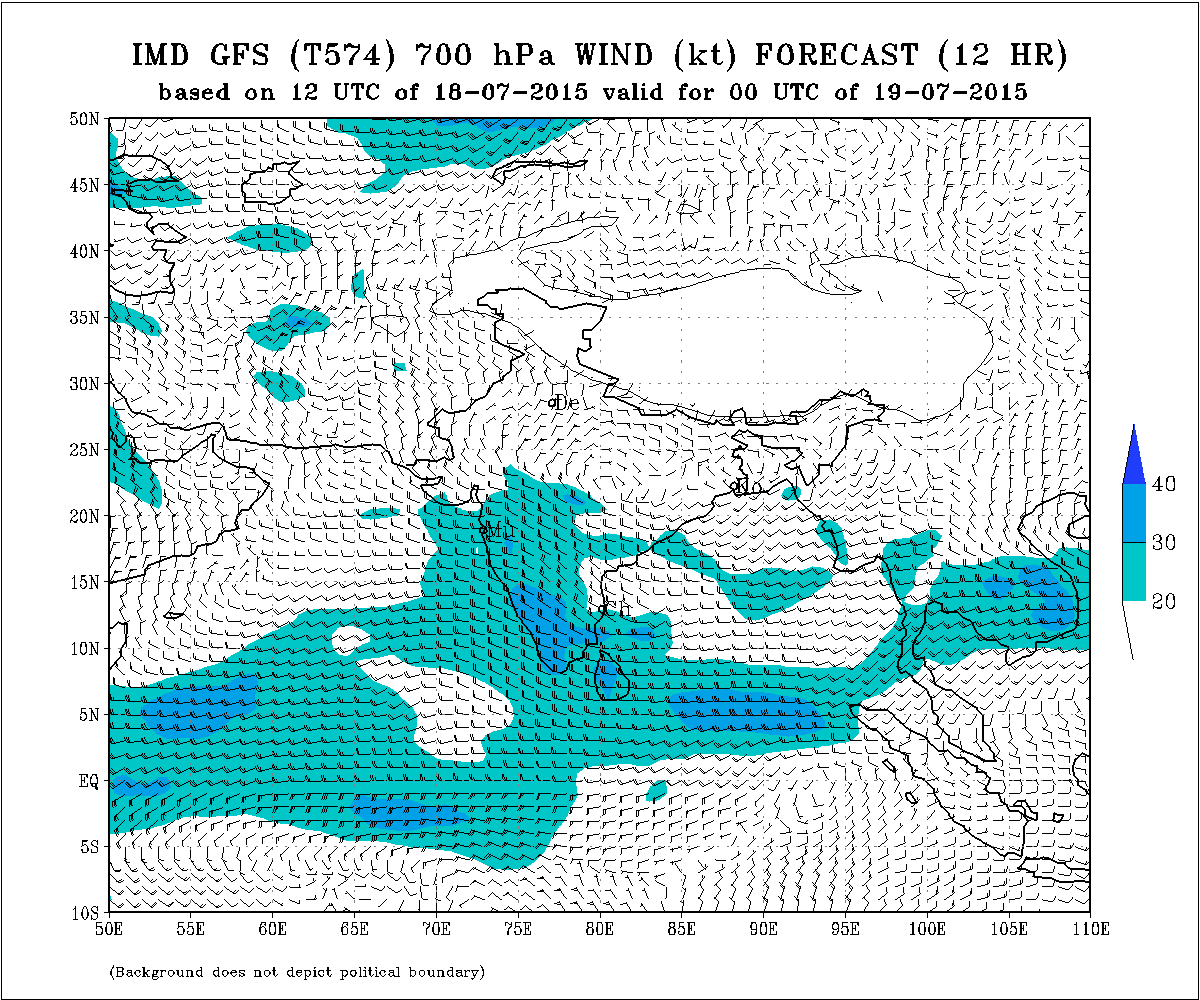
IMD GSF (T574) 700 hPa Forecast Wind Valid 00 UTC 19th July 2015
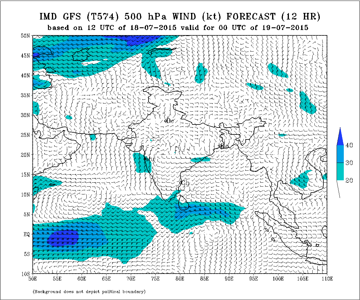
IMD GSF (T574) 500 hPa Forecast Wind Valid 00 UTC 19th July 2015
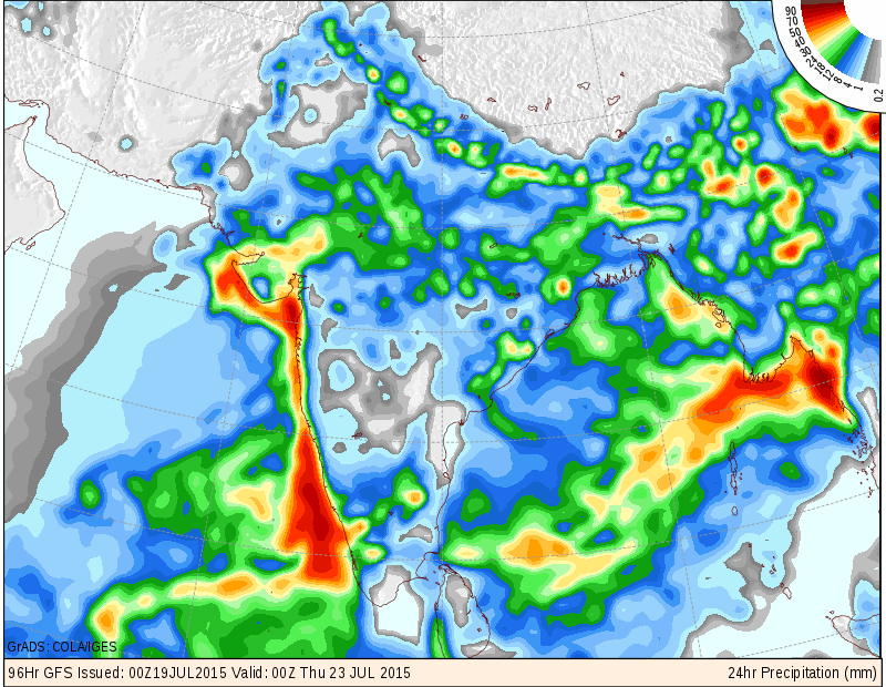
Forecast: 19th July to 23rd July 2015
Saurashtra, Gujarat & Kutch:
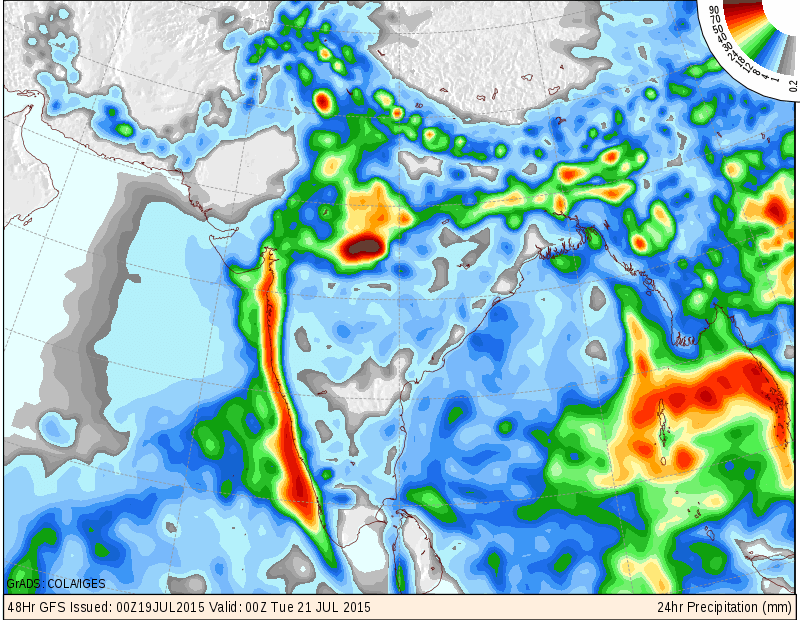
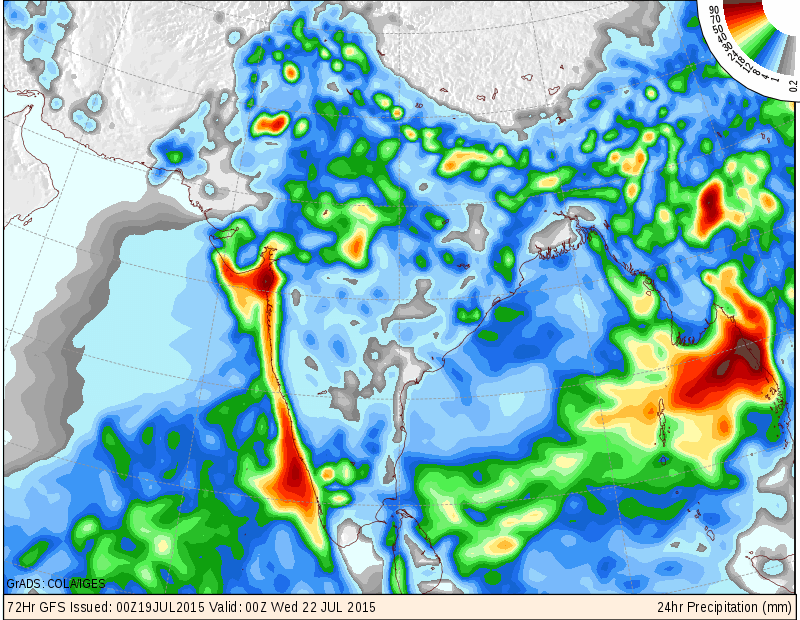
Conditions seem to improve for meaningful round of rainfall expected till 23rd July over whole Gujarat on one/two or multiple days. The main rainfall expected between 20th to 23 rd July. The quantum of rainfall over various regions of Saurashtra, Gujarat & Kutch would be 35 mm. to 60 mm (1.5 inch to 2.5 inches). with some centers getting above 100 mm (4 inches). The quantum is also depicted by Maps below.
COLA/IGES Rainfall Forecast Map valid for 00 UTC 21st July 2015 (for 20th July)
COLA/IGES Rainfall Forecast Map valid for 00 UTC 22nd July 2015 (for 21st July)
COLA/IGES Rainfall Forecast Map valid for 00 UTC 23rd July 2015 (for 22nd July)
તારીખ 19 જૂલાઈ થી 23 જૂલાઈ :
સૌરાષ્ટ્ર ગુજરાત અને કચ્છ:
સૌરાષ્ટ્ર ગુજરાત અને કચ્છ માં સવાર્ત્રિક સંતોષકારક વારસદ નો રાઉન્ડ માટે વાતાવરણ સાનૂકૂળ થતું જાય છે. મુખ્ય વરસાદ 20 જૂલાઈ થી 23 જૂલાઈ દરમ્યાન શક્યતા છે. વરસાદ ની માત્રા નો અંદાજ 35 મીમી થી 60 મીમી (1.5 થી 2.5 ઇંચ ), અને અમૂક વિસ્તાર માં 100 મીમી (4 ઇંચ ) થી પણ વધુ. ક્યાં વિસ્તાર માં હળવો, ક્યાં વિસ્તાર માં મધ્યમ, ક્યાં વિસ્તાર માં ભારે તે માટે ત્રણ દિવસ ના નકશા આપેલ છે. મોડલ આધારિત તેમજ સીસ્ટમ આધારિત વરસાદ હોઈ થોડા ફેર થતા હોઈ છે. છતાં પણ જનરલ રાઉન્ડ છે. અલગ અલગ દિવશે અલગ અલગ વિસ્તાર માં એક, કે બે, કે ત્રણે દિવસે વરસાદ થશે.
સૂચના: કોમેન્ટ માં પ્રશ્ન ઘણા લોકો વાહિયાત પૂછે છે તેમજ રીપીટ પૂછે છે. જેથી ના છૂટકે કોમેન્ટ વ્યવસ્થા બંધ કરવી પડશે. માટે સંયમ રાખો અને અધીરા ના થાઓ. 25 જૂન 2015 થી કમેન્ટ ના જવાબ દિવસ માં એક કે બે વાર એક સાથે આપવામાં આવશે. જવાબ ની રાહ જોવો અને રીપીટ પૂછો નહિ. આગાહી આપેલ છે તેના થી આગળ ના સમય માટે કઈ સાવલ ના કરવા. જેમ જેમ આગળ નું ચિત્ર સ્પષ્ટ થશે તેમ તેમ અપડેટ થશે.
Scroll Up