Current Weather Conditions on 3rd June 2019
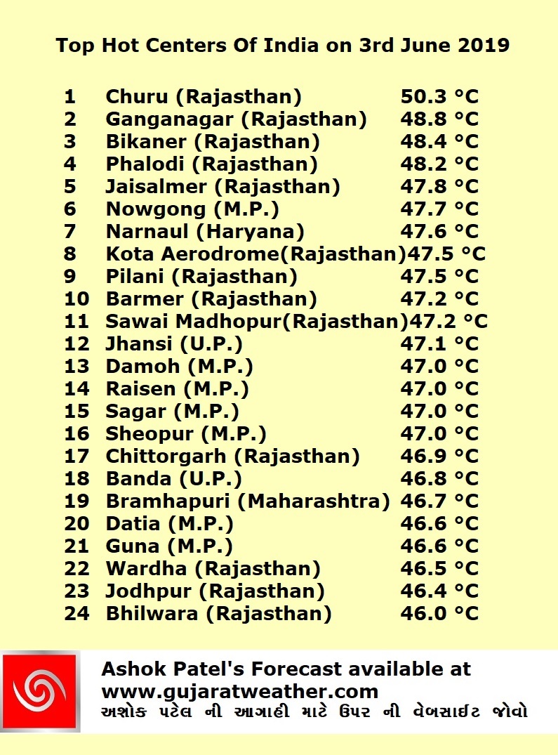
The Maximum Temperature during the last seven days over hot Centers of Saurashtra, Gujarat & Kutch ranged from 43 to 45 C. The Maximum Temperatures today the 3rd June were:
Kandala (A) 44.8 C, Gandhinagar 44.4 C, Surendranagar 44.3 C, Rajkot 44.1 C, Ahmedabad 44.0 C, Deesa 43.2 C.
Moderate windy conditions prevailed over Saurashtra, Gujarat & Kutch on many days, especially in evening period.
Forecast Saurashtra, Gujarat & Kutch 4th June to 10th June 2019
Hot Centers expected over North Gujarat, Eastern Saurashtra and some pockets of Kutch. Maximum Temperature range for Hot Centers of Saurashtra, Kutch & Gujarat are expected to be as under:
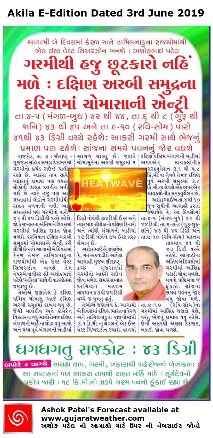
4th & 5th June : 42C to 44C
6th, 7th & 8th June : 43C to 45C
9th & 10th June : 41C to 43C
Moderate wind mainly Westerly directions during the forecast period with higher wind speed 9th/10th June. Saurashtra & Kutch expected to have higher wind speeds compared to Gujarat. Higher wind speed expected mostly in evening periods. There will be a moderate Upper Air instability over Saurashtra, Gujarat & Kutch on 7th & 9th June. Evening Humidity expected to increase during the Forecast period.
Rest Of India:
Kerala & Karnataka: Expected to receive cumulative 3 Cms. to 10 Cms. of rain during the forecast period.
Andaman & Nicobar: Expected to receive cumulative 8 Cms. to 12 Cms. of rain during the forecast period.
There is a differing outcome of development of a System and progress of Monsoon by GFS and ECMWF for the current forecast period. There would be more clarity in the next 2 days.
અરબી સમુદ્ર માં સિસ્ટમ બનવા ની તેમજ ચોમાસા ની પ્રગતિ બાબતે GFS અને ECMWF વચ્ચે મતમતાંતર છે જે બેક દિવસ માં ક્લિયર થશે.
As per IMD:
In view of the deepening of cross equatorial winds up to the Southern parts of South Arabian sea and further to the North over Bay of Bengal and persistent cloudiness over these regions, the Southwest Monsoon has further advanced into Southern most parts of Arabian sea, some more parts of Maldives-Comorin area, Southwest, Southeast and Eastcentral Bay of Bengal. The Northern Limit of Monsoon (NLM) passes through Lat. 6°N/Long. 60°E, Lat. 6°N/Long. 70°E, Lat. 6°N/Long. 81°E, Lat. 10°N/Long. 86°E, Lat. 13°N/Long. 89°E and Lat. 17°N/Long. 95°E.
Cross equatorial flow over Southern parts of South Arabian Sea (to the south of 10° N) is likely to increase gradually favoring
further advance of Southwest Monsoon over some more parts of South Arabian sea, Maldives-Comorin area, Southwest, Southeast and
Central Bay of Bengal during next 48 hours.
An East-West shear zone at 3.1 km above mean sea level is very likely to develop across extreme South Peninsula from 05th June on wards leading to favorable conditions for onset of Southwest Monsoon over Kerala subsequently.
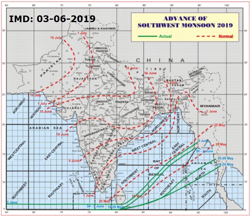
સૌથી ઉપર ની લીલી લીટી ના છેડે જે તારીખ હોઈ તે તારીખે લીટી ની નીચે ના ભાગ માં બધે ચોમાસું પોંચી ગયું છે તેમ સમજવું.
લાલ ત્રુટક લીટી જે તે વિસ્તાર માં નોર્મલ ચોમાસું બેસવાની તારીખ દર્શાવે છે
The date shown at the end of green line shows that the Southwest Monsoon has set in over areas below the green line on that date.
The red dashed line shows the normal date of onset of Southwest Monsoon over various regions
વાંચવા માટે ઇમેજ ક્લીક કરો – Click Image for reading

વાંચવા માટે ઇમેજ ક્લીક કરો – Click Image for reading
વાંચવા માટે ઇમેજ ક્લીક કરો – Click Image for reading