Update of Weather Conditions on 4th December 2017 @ 08.45 pm. IST
The Very Severe Cyclonic Storm ‘OCKHI’ over Eastcentral Arabian Sea moved further North Northeastwards has now weakened into a Severe Cyclonic Storm over East Central Arabian Sea at 17.30 IST today.
1 knot= 1.85 km./hour
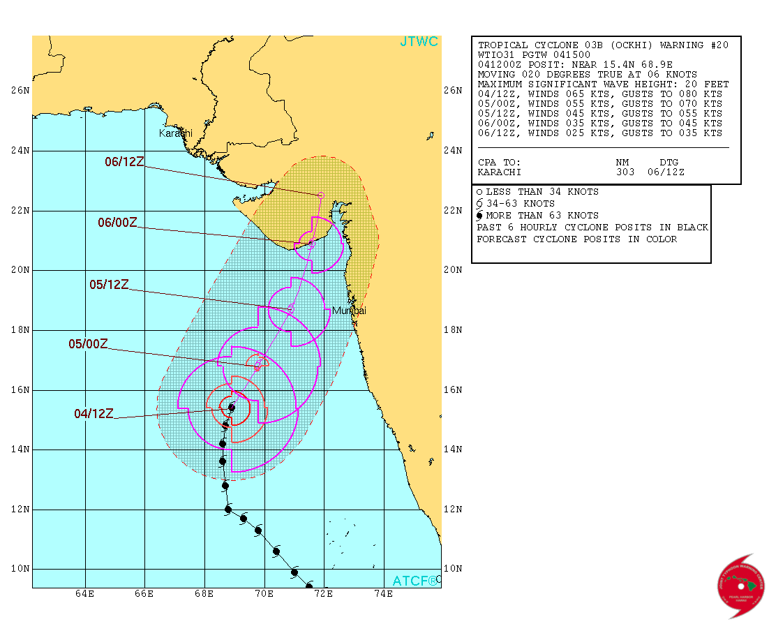
JTWC Tropical Storm 03B (OCKHI) Warning No. 20
On 4th December 2017 @ 1500 UTC ( 08.30 pm. IST) (Very Severe Cyclonic Storm ‘OCKHI’)
Update of Weather Conditions on 4th December 2017 @ 05.00 pm. IST
UW-CIMSS ‘OCKHI’ IR-WV Satellite Image With Cyclone Track & Forecast Cyclone Track
on 4th December 2017 @ 0900 UTC (02.30 pm. IST)

1 knot= 1.85 km./hour
JTWC Tropical Storm 03B (OCKHI) Warning No. 19
On 4th December 2017 @ 0900 UTC ( 02.30 pm. IST) (Very Severe Cyclonic Storm ‘OCKHI’)

નકશામાં લખેલ છે તે તારીખ અને ટાઈમ છે.
05/06Z એટલે 5 તારીખ અને 06 Z એટલે સવારે 11.30 IST
04/18Z એટલે 4 તારીખ અને 18 Z એટલે રાત્રે 11.30 IST
ઇન્ટરનૅશનલ એજન્સી મુજબ વધી ને 100 નૉટ પવન ની ઝડપ હાલ 70 નૉટ પવન ની ઝડપ છે ( જે એક મિનિટ ની શરેરાશ પવન મુજબ ગણે છે ,જયારે હવામાન ખાતા મુજબ પવન ની ઝડપ 3 મિનિટ ની શરેરાશ મુજબ ગણતરી થાય.)
INDIA METEOROLOGICAL DEPARTMENT
BULLETIN NO. : 41 (BOB 07/2017)
TIME OF ISSUE: 1620 HOURS IST DATED: 04.12.2017
Here below is a four page Document. Click Page Up Down arrows at the bottom left corner on the Document page to read all the pages.
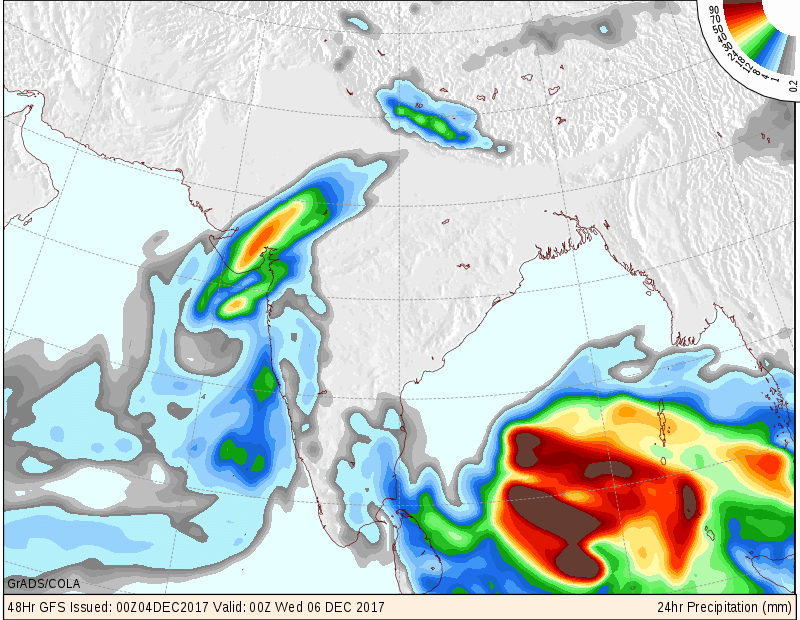
Very Severe Cyclonic Storm ‘OCKHI’ over East Central Arabian Sea has crossed 15N this afternoon. International Agencies have this System weakened from a maximum of 100 knots to currently 70 knots wind speed (based on 1 minute average wind speed) & 983 mb pressure, location Lat. 15.1 N & Long 69.0 E about 650 kms South Southwest from Saurashtra coast.The System is expected to gradually weaken as it tracks North Northeasterly direction during the next two days towards West Indian coast. System expected to pass 100 km. West of Mumbai by evening 5th December. The winds could range from 40km/hour to 60 km/hour near System affected areas of Saurashtra & Gujarat when the System nears land. Unseasonal rain for Saurashtra, Gujarat & Kutch & adjoining States during 4th to 6th December 2017 expected. The Maximum Temperature over most parts of Saurashtra, Gujarat & Kutch will decrease drastically on 4th/6th December 2017, and could be rarely observed Maximum Temperature.
Eastern Saurashtra, South Gujarat, East Central Gujarat, Northeast Gujarat expected to get from scattered showers to 7 Cm. during the forecast period 4th to 6th December 2017.
Kutch, rest of Saurashtra, rest of North Gujarat expected to get scattered showers during the forecast period.
The major quantum of rain expected before the System reaches land.
The Well Marked Low Pressure over Southeast Bay of Bengal & neighborhood with associated UAC extending up to 5.8 km above mean sea persist. It is expected to track towards South Indian Coast during the next few days while concentrating further to a Depression System.
Note: IMD considers wind speed based on 3 minute Average in their System classifications.
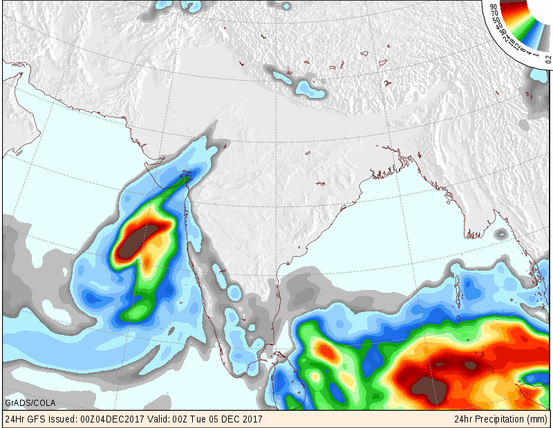
COLA Precipitation Forecast Valid for 24 hours from 4th December up to 5th December 2017 @ 05.30 am.
COLA Precipitation Forecast Valid for 24 hours from 5th December up to 6th December 2017 @ 05.30 am.
અપડેટ 4th December 2017
અતિ તીવ્ર વાવાઝોડુ OCKHI’ મધ્ય પૂર્વ અરબી સમદ્ર માં છે જે આજે બપોરે લેટિટ્યૂડ 15 ને ક્રોસ કરેલ છે. પવન 120 કિમી ની ઝડપ અને ઝાટકા ના પવનો 140 કિમી ની ઝડપે ફૂંકાય છે IMD મુજબ. સિસ્ટમ ક્રમશ નબળી પડશે. આવતી કાલે સાંજ પહેલા સિસ્ટમ મુંબઈ થી 100 કિમી પશ્ચિમ બાજુ થી પાસ થશે ત્યારે ડિપ્રેસન કે ડીપ ડિપ્રેસન જેવી માત્રા હશે. સિસ્ટમ નબળી પડતી હોવા થી પવન માત્રા ઘટશે, માત્રા 40 કિમી થી 60 કિમી સિસ્ટમ નજીક ના અસર કરતા વિસ્તારો માં. સિસ્ટમ હવે ઉત્તર ઉત્તર પૂર્વ બાજુ ટ્રેક કરશે, જે દક્ષિણ ગુજરાત અને સૌરાષ્ટ્ર ના પૂર્વ કિનારા તરફ આગળ વધે છે. વાદળ સમૂહો ગુજરાત સુધી ફેલાયેલ છે. તારીખ 4 થી 6 માં માવઠા ની શક્યતા છે. તારીખ 4થી 6 ડિસેમ્બર દરમિયાન મહત્તમ તાપમાન માં નોંધપાત્ર ઘટાડો જોવા મળશે જે જોવા મળેલ ના હોય તેવો.
આગાહી સમય 4થી 6 તારીખ સુધી માં પૂર્વ સૌરાષ્ટ્ર, દક્ષિણ ગુજરાત, માધ્ય ગુજરાત, પૂર્વ ઉત્તર ગુજરાત માં છુટા છવાયા ઝાપટા થી લઇ ને 5 – 7 CM (સેન્ટિમીટર) વરસાદ ની સંભવના છે.
કચ્છ, બાકી નું સૌરાષ્ટ્ર, બાકી નું ઉત્તર ગુજરાત માં છુટા છવાયા ઝાપટા.
તમારા વિસ્તાર ના વરસાદ ની સંભાવના માટે વન્ડર ગ્રાઉન્ડ માં જોવો, તેમજ સાથે આપેલ COLA નકશા જોવો
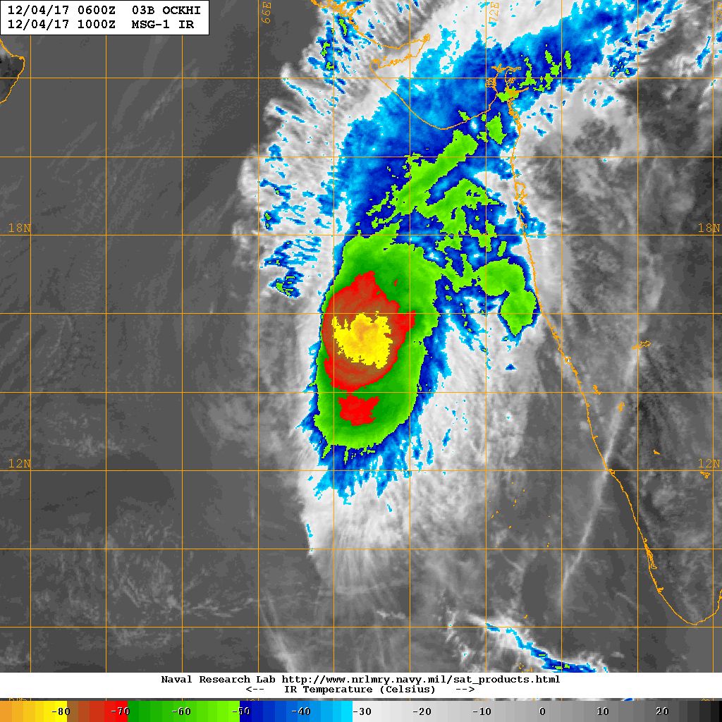
NRL IR Satellite Image of Cyclone 03B.OCKHI (Severe Cyclonic Storm ‘OCKHI’ )
on 4th December 2017 @ 1000 UTC (3.30 pm. IST)
Caution: Please refer/rely on IMD/RSMC Bulletins/Advisories for Storms & Weather related matter.
સાવચેતી:
સ્ટોર્મ કે હવામાન અંગે ની માહિતી માટે ભારતીય હવામાન ખાતા/ગવર્મેન્ટ ના બુલેટીન/સુચના પર નિર્ભર રહેવું.