Current Weather Conditions on 21st November 2013 @ 9.00 am.
Deep Depression over West Central Bay of Bengal of 19th November intensified rapidly to a Cyclonic Storm ” HELEN” on 20th morning and lay at 15.0 N. & Long. 84.0 E. with winds of 35 knots. The System has remained quazi-stationary during the last 12 to 18 hours with the Center of the System remaining within 0.5 Degree. System is expected to strengthen further and track towards Coastal Andhra Pradesh and make landfall vicinity Machilipatnam on 22nd November 2013.
As Per IMD/RSMC:
Time of issue: 0530 hours IST Dated: 21-11-2013
Bulletin No.: BOB06/2013/14
Sub: Cyclonic Storm, HELEN over westcentral Bay of Bengal
Cyclone Warning for south Andhra Pradesh and adjoining north Tamil Nadu coasts: Orange Message
The cyclonic storm ‘HELEN’ over westcentral Bay of Bengal moved slightly west-northwestwards and lay centred at 0230 hrs IST of today, the 21st November 2013 near latitude 15.50N and longitude 83.60E, about 460 km east-northeast of Chennai, 390 km east of Kavali, 270 km east-southeast of Machillipatnam and 250 km south-southeast of Vishakhapatnam. The system would further intensify into a severe cyclonic storm during next 24 hrs. It would move west-northwestwards slowly for some time, then west-southwestward and cross south Andhra Pradesh coast between Nellore and Machillipatnam, close to Ongole around afternoon of 22nd November 2013.
Warning for Andhra Pradesh, north Tamil Nadu and Puducherry coasts
(i)Rainfall
Under its influence, rainfall at most places with heavy to very heavy rainfall at a few places would occur over coastal Andhra Pradesh commencing from 21st November 2013 forenoon. Isolated extremely heavy falls (25cm or more) would occur over south coastal Andhra Pradesh on 21st and 22nd November. Rainfall at most places with isolated heavy to very heavy falls would occur over Rayalseema and adjoining north Tamil Nadu on 22nd November. Moderate rainfall would occur at many places over south Odisha on 21st November.
(ii)Squally/Gale Winds
Squally winds speed reaching 55-65 kmph gusting to 75 kmph would prevail along and off south Andhra Pradesh coast commencing from 21st November 2013 forenoon. The wind speed would gradually increase upto gale wind speed of 100-110 kmph, gusting to 120 kmph at the time of landfall. Squally winds speed reaching 55-65 kmph gusting to 75 kmph would prevail along and off north Andhra Pradesh, north Tamil Nadu and Puducherry coasts at the time of landfall.
(iii)Storm Surge
Storm surge of about 1 to 1.5m height above astronomical tide would inundate the low lying areas of Nellore, Prakasham, Guntur and Krishna districts of Andhra Pradesh at the time of landfall.
(iv)Sea condition
Sea condition will be rough to very rough along and off south Andhra Pradesh coasts from 21st November 2013 forenoon, becoming very high from 21st November 2013 morning onwards. It will be rough to very rough along and off north Andhra Pradesh, north Tamil Nadu and Puducherry coasts during the same period.
(v)Damage expected due to a cyclonic storm over south coastal Andhra Pradesh
Extensive damage to thatched roofs and huts. Minor damage to power and communication lines due to uprooting of large avenue trees. Flooding of escape roots.
(vi)Action Suggested
· South Andhra Pradesh coast
Total suspension of fishing operations. Coastal hutment dwellers to be moved to safer place. People in affected areas to remain indoors.
· North Andhra Pradesh and north Tamil Nadu coasts
Fishermen are advised not to venture into sea.
From JTWC:
WTIO31 PGTW 210300
MSGID/GENADMIN/JOINT TYPHOON WRNCEN PEARL HARBOR HI//
SUBJ/TROPICAL CYCLONE 04B (HELEN) WARNING NR 007//
RMKS/
1. TROPICAL CYCLONE 04B (HELEN) WARNING NR 007
   01 ACTIVE TROPICAL CYCLONE IN NORTHIO
   MAX SUSTAINED WINDS BASED ON ONE-MINUTE AVERAGE
   WIND RADII VALID OVER OPEN WATER ONLY
    ---
   WARNING POSITION:
   210000Z --- NEAR 15.8N 83.6E
     MOVEMENT PAST SIX HOURS - 305 DEGREES AT 04 KTS
     POSITION ACCURATE TO WITHIN 030 NM
     POSITION BASED ON CENTER LOCATED BY SATELLITE
   PRESENT WIND DISTRIBUTION:
   MAX SUSTAINED WINDS - 060 KT, GUSTS 075 KT
   WIND RADII VALID OVER OPEN WATER ONLY
   RADIUS OF 050 KT WINDS - 025 NM NORTHEAST QUADRANT
                            015 NM SOUTHEAST QUADRANT
                            025 NM SOUTHWEST QUADRANT
                            030 NM NORTHWEST QUADRANT
   RADIUS OF 034 KT WINDS - 070 NM NORTHEAST QUADRANT
                            045 NM SOUTHEAST QUADRANT
                            050 NM SOUTHWEST QUADRANT
                            070 NM NORTHWEST QUADRANT
   REPEAT POSIT: 15.8N 83.6E
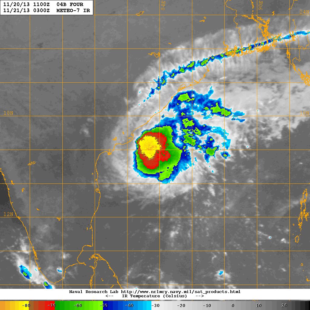
NRL IR Satellite Image Of 04B.FOUR (Cyclonic Storm “HELEN”) Over BOB
on 21st November at 0300 UTC ( 9.00 am. IST)
As Per UW-CIMSS:
| UW-CIMSS Automated Satellite-Based Advanced Dvorak Technique (ADT) Version 8.1.5 Tropical Cyclone Intensity Estimation Algorithm |
|
| Current Intensity Analysis | |
                     UW - CIMSS
              ADVANCED DVORAK TECHNIQUE
                  ADT-Version 8.1.5
         Tropical Cyclone Intensity Algorithm

             ----- Current Analysis -----
     Date :  21 NOV 2013    Time :   030000 UTC
      Lat :   15:33:00 N     Lon :   83:51:49 E


                CI# /Pressure/ Vmax
                4.3 / 979.9mb/ 72.2kt


             Final T#  Adj T#  Raw T#
                4.3     4.3     3.5

 Center Temp : -70.4C    Cloud Region Temp : -71.7C

 Scene Type : UNIFORM CDO CLOUD REGION w/ MW EYE

 Positioning Method : SPIRAL ANALYSIS

 Ocean Basin : INDIAN
 Dvorak CI > MSLP Conversion Used : PACIFIC

 Tno/CI Rules : Constraint Limits : MW ON
                   Weakening Flag : OFF
           Rapid Dissipation Flag : OFF

 C/K/Z MSLP Estimate Inputs :
  - Average 34 knot radii :   58km
  - Environmental MSLP    : 1008mb

 Satellite Name :    MET7
 Satellite Viewing Angle : 35.8 degrees
|