40°C–42.5°C Temperatures Likely Over Saurashtra, Gujarat & Kutch During 6th–11th June; Decline Expected Around 12th–13th June – Isolated Pre-Monsoon Activity Likely Over Gujarat State
સૌરાષ્ટ્ર, ગુજરાત અને કચ્છમાં 6થી 11 જૂન દરમિયાન 40°C–42.5°C તાપમાનની શક્યતા; 12મી–13મી જૂને ઘટાડો થવાની સંભાવના – ગુજરાત રાજ્યમાં છૂટાછવાયા પ્રી-મોન્સૂન એક્ટિવિટીની શક્યતા
Gujarat Temperature Observations (5th June 2026)
Maximum temperatures were around near normal to about 1°C below normal across many hot centers of Gujarat State.
- Rajkot: 40.6°C (0.4°C above normal)
- Deesa: 39.2°C (1.3°C below normal)
- Amreli: 40.1°C (0.3°C above normal)
- Ahmedabad: 41.3°C (0.4°C above normal)
- Vadodara: 39.4°C (0.1°C above normal)
- Surendranagar: 40.4°C (1.3°C below normal)
Current normal maximum temperatures across most parts of Gujarat are around 39.5°C to 40.5°C. Ahmedabad and Surendranagar have normal maximum temperatures near 41°C.
Advance of Southwest Monsoon 2026
As per the IMD Mid-Day Bulletin:
The Southwest Monsoon has further advanced into additional parts of the west-central and east-central Arabian Sea, Karnataka, the entire Goa region, parts of Maharashtra and Andhra Pradesh, most parts of Tamil Nadu and the southwest Bay of Bengal. It has also advanced into more areas of the west-central, northeast and east-central Bay of Bengal, along with parts of Mizoram and Manipur.
The Northern Limit of Monsoon (NLM) now passes through:
17.5°N/60°E, 17.5°N/65°E, 17°N/70°E, Devgad, Koppal, Anantapuramu, Chennai, 15.5°N/85°E, 20°N/89.5°E, Aizawl and 25°N/95°E.
Conditions remain favorable for further advance of the Southwest Monsoon into additional parts of the central Arabian Sea, Maharashtra, Karnataka and Andhra Pradesh, parts of Telangana, the remaining areas of Tamil Nadu and southwest Bay of Bengal, as well as more parts of the west-central and northern Bay of Bengal and the Northeastern States during the next 2–3 days.
The seasonal trough at mean sea level currently extends from Suratgarh to Rohtak, Rewa, Ranchi and Canning, and thereafter southeastwards into the northeast Bay of Bengal.
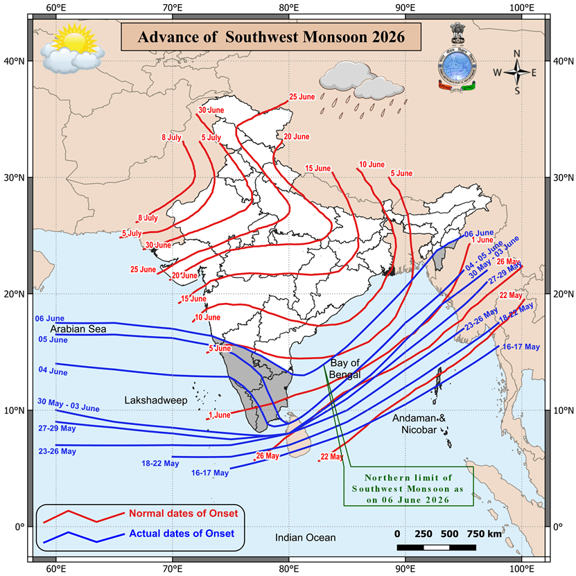
As per the Southwest Monsoon map above, the Monsoon advanced northwards by approximately 8 degrees latitude along the West Coast, from around 8°N to 16.2°N. This corresponds to a movement of roughly 880 km.
However, this does not imply that the Monsoon will continue advancing at the same pace during the remainder of its journey. Under normal conditions, as per IMD climatology, the Southwest Monsoon typically takes around 14 days to cover the entire Gujarat State, beginning with South Gujarat and coastal Saurashtra, followed by the rest of Saurashtra, Gujarat Region and Kutch. This corresponds broadly to the 14th June to 28th June period.
Weather Forecast For Saurashtra, Gujarat & Kutch (6th–13th June 2026)
Temperature Outlook
Maximum temperatures are expected to rise gradually by around 1°C during 6th–8th June and by a further 1°C during 9th–11th June, becoming above normal over most centers during that period.
Most hot centers across Gujarat are likely to record maximum temperatures in the range of 40.5°C to 42.5°C during 9th–11th June.
A marginal decline in temperatures is expected around 12th–13th June.
Winds
- Predominantly Southwest winds during the forecast period.
- Wind speeds are expected to vary between 10 km/h and 35 km/h.
Pre-Monsoon Activity
Isolated pre-monsoon activity is expected on a few days during the forecast period.
Understanding the Rainfall Coverage Forecast
The IMD Morning Bulletin dated 6th June 2026 has the rainfall coverage forecast for both Saurashtra & Kutch and Gujarat Region shows Isolated rainfall activity throughout the forecast period.
The term Isolated refers to rainfall occurring over 1% to 25% of the area. It does not indicate the amount of rainfall expected.
Therefore, even if rainfall occurs over only 1% of Saurashtra & Kutch and similarly over 1% of Gujarat Region, the forecast would be considered verified.
Saurashtra & Kutch and similarly Gujarat Region, the forecast above is validated.
સૌરાષ્ટ્ર, ગુજરાત અને કચ્છમાં 6થી 11 જૂન દરમિયાન 40°C–42.5°C તાપમાનની શક્યતા; 12મી–13મી જૂને ઘટાડો થવાની સંભાવના – ગુજરાત રાજ્યમાં છૂટાછવાયા પ્રી-મોન્સૂન એક્ટિવિટીની શક્યતા
ગુજરાતના તાપમાનના અવલોકનો (5 જૂન 2026)
ગુજરાત રાજ્યના ઘણા ગરમ કેન્દ્રોમાં મહત્તમ તાપમાન નોર્મલની આસપાસથી લઈને આશરે 1°C નોર્મલથી નીચે નોંધાયું હતું.
- રાજકોટ: 40.6°C (નોર્મલ કરતાં 0.4°C વધુ)
- ડીસા: 39.2°C (નોર્મલ કરતાં 1.3°C ઓછું)
- અમરેલી: 40.1°C (નોર્મલ કરતાં 0.3°C વધુ)
- અમદાવાદ: 41.3°C (નોર્મલ કરતાં 0.4°C વધુ)
- વડોદરા: 39.4°C (નોર્મલ કરતાં 0.1°C વધુ)
- સુરેન્દ્રનગર: 40.4°C (નોર્મલ કરતાં 1.3°C ઓછું)
ગુજરાતના મોટાભાગના વિસ્તારોમાં હાલનું નોર્મલ મહત્તમ તાપમાન આશરે 39.5°C થી 40.5°C વચ્ચે છે. અમદાવાદ અને સુરેન્દ્રનગરનું નોર્મલ મહત્તમ તાપમાન આશરે 41°C છે.
દક્ષિણપશ્ચિમ ચોમાસાની 2026ની પ્રગતિ
IMDના મીડ ડે બુલેટિન મુજબ:
IMDના 6 જૂન 2026ના મીડ ડે બુલેટિન મુજબ, દક્ષિણપશ્ચિમ ચોમાસું પશ્ચિમ મધ્ય અને પૂર્વ મધ્ય અરબી સમુદ્રના વધુ વિસ્તારો, સમગ્ર ગોવા, કર્ણાટક, મહારાષ્ટ્ર અને આંધ્ર પ્રદેશના કેટલાક ભાગો, તમિલનાડુના મોટાભાગના વિસ્તારો તથા દક્ષિણપશ્ચિમ બંગાળની ખાડીમાં વધુ આગળ વધ્યું છે. ઉપરાંત, પશ્ચિમ મધ્ય, ઉત્તરપૂર્વ અને પૂર્વ મધ્ય બંગાળની ખાડીના વધુ વિસ્તારો તેમજ મિઝોરમ અને મણિપુરના કેટલાક ભાગોમાં પણ ચોમાસું આગળ વધ્યું છે.
ચોમાસાની ઉત્તર સીમા (Northern Limit of Monsoon – NLM) હાલમાં નીચે મુજબ પસાર થાય છે:
17.5°N/60°E, 17.5°N/65°E, 17°N/70°E, દેવગઢ, કોપ્પલ, અનંતપુરમુ, ચેન્નાઈ, 15.5°N/85°E, 20°N/89.5°E, આઇઝોલ અને 25°N/95°E.
આગામી 2–3 દિવસ દરમિયાન મધ્ય અરબી સમુદ્રના વધુ વિસ્તારો, મહારાષ્ટ્ર, કર્ણાટક અને આંધ્ર પ્રદેશના કેટલાક વધુ ભાગો, તેલંગાણાના કેટલાક વિસ્તારો, તમિલનાડુ અને દક્ષિણપશ્ચિમ બંગાળની ખાડીના બાકીના વિસ્તારો તેમજ પશ્ચિમ મધ્ય અને ઉત્તર બંગાળની ખાડીના વધુ વિસ્તારો અને ઉત્તરપૂર્વીય રાજ્યોમાં દક્ષિણપશ્ચિમ ચોમાસું વધુ આગળ વધવા માટે પરિસ્થિતિ અનુકૂળ છે.
સરેરાશ સમુદ્ર સપાટીએ આવેલ મોસમી ટ્રફ (Seasonal Trough) હાલમાં સુરતગઢ, રોહતક, રીવા, રાંચી અને કેનિંગમાંથી પસાર થઈ ત્યારબાદ દક્ષિણપૂર્વ દિશામાં ઉત્તરપૂર્વ બંગાળની ખાડી તરફ વિસ્તરે છે.
ઉપર દર્શાવેલા દક્ષિણપશ્ચિમ ચોમાસાના નકશા મુજબ પશ્ચિમ કિનારે ચોમાસું આશરે 8 અક્ષાંશ ડિગ્રી ઉત્તર તરફ આગળ વધ્યું છે, એટલે કે લગભગ 8°N થી 16.2°N સુધી. આ આશરે 880 કિલોમીટર જેટલી ઉત્તર દિશાની પ્રગતિ દર્શાવે છે.
જો કે, તેનો અર્થ એવો નથી કે આગામી દિવસોમાં પણ ચોમાસું આ જ ગતિએ આગળ વધશે. સામાન્ય પરિસ્થિતિમાં, IMDના મોન્સૂન નકશા મુજબ ચોમાસુ પહેલા દક્ષિણ ગુજરાત અને સૌરાષ્ટ્રના દરિયાકાંઠાના વિસ્તારોમાં પ્રવેશ કર્યા બાદ બાકી ના સૌરાષ્ટ્ર તેમજ ગુજરાત રિજિયન અને કચ્છમાં ચોમાસું આગળ વધે છે. આ ચોમાસુ બેસવાની પ્રક્રિયા સામાન્ય રીતે 14 જૂનથી 28 જૂનના સમયગાળામાં પૂર્ણ થાય છે.
સૌરાષ્ટ્ર, ગુજરાત અને કચ્છ માટે હવામાન આગાહી (6થી 13 જૂન 2026)
તાપમાન અંગે આગાહી
મહત્તમ તાપમાનમાં 6થી 8 જૂન દરમિયાન આશરે 1°Cનો વધારો થવાની અને ત્યારબાદ 9થી 11 જૂન દરમિયાન વધુ 1°Cનો વધારો થવાની શક્યતા છે. આ સમયગાળા દરમિયાન મોટાભાગના કેન્દ્રોમાં તાપમાન નોર્મલ કરતાં ઊંચું રહેવાની સંભાવના છે.
ગુજરાતના મોટાભાગના ગરમ કેન્દ્રોમાં 9થી 11 જૂન દરમિયાન મહત્તમ તાપમાન 40.5°C થી 42.5°C વચ્ચે નોંધાવાની શક્યતા છે.
ત્યારબાદ 12મી અને 13મી જૂને તાપમાનમાં નજીવો ઘટાડો થવાની સંભાવના છે.
પવનો
- આગાહી સમયગાળા દરમિયાન મુખ્યત્વે દક્ષિણપશ્ચિમ દિશાના પવનો રહેશે.
- પવનની ઝડપ આશરે 10 કિમી/કલાકથી 35 કિમી/કલાક વચ્ચે રહેવાની શક્યતા છે.
પ્રી-મોન્સૂન એક્ટિવિટી
આગાહી સમયગાળા દરમિયાન અમુક દિવસોમાં છૂટાછવાયા વિસ્તારોમાં પ્રી-મોન્સૂન એક્ટિવિટી થવાની શક્યતા છે.
વરસાદી કવરેજની આગાહી સમજીએ
IMD ના સવાર ના બુલેટિન મુજબ સૌરાષ્ટ્ર-કચ્છ તેમજ ગુજરાત રિજિયન માટે વરસાદી કવરેજની આગાહીમાં સમગ્ર સમયગાળા દરમિયાન આઇસોલેટેડ (Isolated) વરસાદ દર્શાવવામાં આવ્યો છે.
આઇસોલેટેડ નો અર્થ એ થાય છે કે સંબંધિત વિસ્તારના આશરે 1% થી 25% વિસ્તારમાં વરસાદી પ્રવૃત્તિ થઈ શકે છે. આ શબ્દ વરસાદના જથ્થા (માત્રા ) અંગે કોઈ માહિતી આપતો નથી.
અટલે કે, જો સૌરાષ્ટ્ર-કચ્છના માત્ર 1% વિસ્તારમાં અને તે જ રીતે ગુજરાત પ્રદેશના માત્ર 1% વિસ્તારમાં વરસાદ થાય, તો પણ ઉપરોક્ત આગાહી માન્ય ગણાય.
Caution: Please refer/rely on IMD/RSMC Bulletins/Advisories for Storms & Weather related matter.
સાવચેતી: સ્ટોર્મ કે હવામાન અંગે ની માહિતી માટે ભારતીય હવામાન ખાતા/ગવર્મેન્ટ ના બુલેટીન/સુચના પર નિર્ભર રહેવું.
Read Comment Policy – કમેન્ટ માટે માર્ગદર્શન વાંચો
How To Upload Profile Picture For WordPress – વર્ડપ્રેસ માં પ્રોફાઈલ પિક્ચર કેમ રાખવું
Forecast In Akila Daily Dated 6th June 2026
Forecast In Sanj Samachar Daily Dated 6th June 2026