Isolated Pre-Monsoon Activity Likely Over Saurashtra, Gujarat & Kutch During 13th–20th June 2026 – Temperature Likely To Decline To Range 38.5°C–41.0°C
13થી 20 જૂન 2026 દરમિયાન સૌરાષ્ટ્ર, ગુજરાત અને કચ્છમાં આઇસોલેટેડ પ્રી-મોન્સૂન એક્ટિવિટીની શક્યતા – મહત્તમ તાપમાન 38.5°C થી 41.0°Cની રેન્જમાં રહેવાની સંભાવના
Gujarat Temperature Observations (12th June 2026)
Maximum temperatures were around near normal to about 3°C above normal across many hot centers of Gujarat State.
- Rajkot: 40.9°C (2.2°C above normal)
- Deesa: 39.8°C (0.2°C above normal)
- Amreli: 39.3°C (1.5°C above normal)
- Ahmedabad: 42.7°C (3.0°C above normal)
- Vadodara: 40.4°C (1.1°C above normal)
- Surendranagar: 41.8°C (2.4°C above normal)
Current normal maximum temperatures across most parts of Gujarat has now decreased to around 38.5°C to 39.5°C. Ahmedabad has normal maximum temperatures near 40°C.
Advance of Southwest Monsoon 2026
As per the IMD Bulletin:
The Northern Limit of Monsoon continues to pass through 18°N/60°E, 18°N/65°E, 18°N/70°E, Harnai, Solapur, Hyderabad, Bhadradri Kothagudem, Kalingapatnam, Paradeep, Baripada, Purulia, Dhanbad, Muzaffarpur and 28.3°N/83°E as on 13th June, 2026.
Conditions are favorable for further advance of southwest monsoon into remaining parts of Karnataka, Telangana, Andhra Pradesh, West Bengal, some more parts of Odisha and some parts of South Chhattisgarh during next 2-3 days.
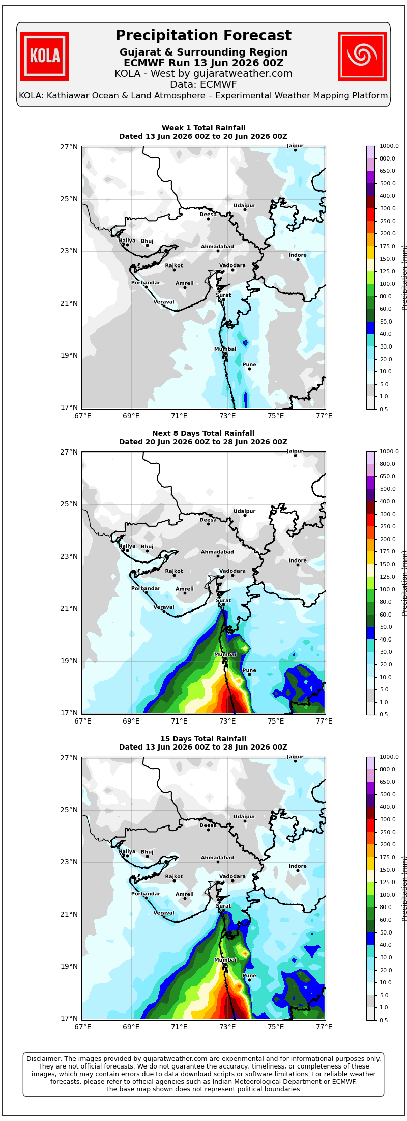
Weather Forecast For Saurashtra, Gujarat & Kutch (13th-20th June 2026)
Pre-Monsoon Activity
Isolated pre-monsoon activity is expected on some days during the forecast period.
The term Isolated refers to rainfall occurring over 1% to 25% of the area. It does not indicate the amount of rainfall expected.
Temperature Outlook
Maximum temperatures are expected to decline by around 1°C to 1.5°C in next two days and is expected to be near normal over most centers during the rest of the forecast period.
Most hot centers across Gujarat are likely to record maximum temperatures in the range of 38.5°C to 41.0°C.
Winds
- Predominantly Southwest winds during the forecast period.
- Wind speeds are expected to vary between 15 km/h and 40 km/h.
13થી 20 જૂન 2026 દરમિયાન સૌરાષ્ટ્ર, ગુજરાત અને કચ્છમાં આઇસોલેટેડ પ્રી-મોન્સૂન એક્ટિવિટીની શક્યતા – મહત્તમ તાપમાન 38.5°C થી 41.0°Cની રેન્જમાં રહેવાની સંભાવના
ગુજરાત તાપમાન અવલોકન (12 જૂન 2026)
ગુજરાત રાજ્યના ઘણા ગરમ કેન્દ્રોમાં મહત્તમ તાપમાન નોર્મલ આસપાસથી લઈને નોર્મલ કરતાં આશરે 3°C સુધી વધુ નોંધાયું હતું.
- રાજકોટ: 40.9°C (નોર્મલ કરતાં 2.2°C વધુ)
- ડીસા: 39.8°C (નોર્મલ કરતાં 0.2°C વધુ)
- અમરેલી: 39.3°C (નોર્મલ કરતાં 1.5°C વધુ)
- અમદાવાદ: 42.7°C (નોર્મલ કરતાં 3.0°C વધુ)
- વડોદરા: 40.4°C (નોર્મલ કરતાં 1.1°C વધુ)
- સુરેન્દ્રનગર: 41.8°C (નોર્મલ કરતાં 2.4°C વધુ)
હાલમાં ગુજરાતના મોટા ભાગના વિસ્તારોમાં નોર્મલ મહત્તમ તાપમાન હવે ઘટ્યું છે જે લગભગ 38.5°C થી 39.5°C ગણાય. અમદાવાદમાં નોર્મલ મહત્તમ તાપમાન લગભગ 40°C આસપાસ ગણાય.
દક્ષિણ-પશ્ચિમ ચોમાસાની પ્રગતિ 2026
IMD બુલેટિન મુજબ:
13 જૂન 2026ના રોજ ચોમાસાની ઉત્તર સીમા (Northern Limit of Monsoon) 18°N/60°E, 18°N/65°E, 18°N/70°E, હરનાઈ, સોલાપુર, હૈદરાબાદ, ભદ્રાદ્રી કોઠાગુડેમ, કાલિંગપટ્ટનમ, પારાદીપ, બારીપદા, પુરુલિયા, ધનબાદ, મુઝફ્ફરપુર અને 28.3°N/83°Eમાંથી પસાર થઈ રહી છે.
આગામી 2 થી 3 દિવસ દરમિયાન દક્ષિણ-પશ્ચિમ ચોમાસું કર્ણાટક, તેલંગાણા, આંધ્ર પ્રદેશ અને પશ્ચિમ બંગાળના બાકીના વિસ્તારોમાં તેમજ ઓડિશાના વધુ કેટલાક ભાગો અને દક્ષિણ છત્તીસગઢના કેટલાક વિસ્તારોમાં આગળ વધવા માટે પરિસ્થિતિ અનુકૂળ છે.
સૌરાષ્ટ્ર, ગુજરાત અને કચ્છ માટે હવામાન આગાહી (13થી 20 જૂન 2026)
પ્રી-મોન્સૂન એક્ટિવિટી
આગાહી સમયગાળા દરમિયાન કેટલાક દિવસોમાં આઇસોલેટેડ પ્રી-મોન્સૂન એક્ટિવિટીની શક્યતા છે.
“આઇસોલેટેડ” (Isolated) શબ્દનો અર્થ એ છે કે વિસ્તારના 1% થી 25% ભાગમાં વરસાદી પ્રવૃત્તિ થઈ શકે. તેનો અર્થ વરસાદના પ્રમાણ સાથે સંબંધિત નથી.
તાપમાન
આગામી બે દિવસ દરમિયાન મહત્તમ તાપમાનમાં આશરે 1°C થી 1.5°Cનો ઘટાડો થવાની શક્યતા છે અને ત્યારબાદ આગાહી સમયગાળા દરમિયાન મોટા ભાગના કેન્દ્રોમાં તાપમાન નોર્મલ આસપાસ રહેવાની સંભાવના છે.
ગુજરાતના મોટા ભાગના ગરમ કેન્દ્રોમાં મહત્તમ તાપમાન 38.5°C થી 41.0°Cની રેન્જમાં નોંધાવાની શક્યતા છે.
પવન
આગાહી સમયગાળા દરમિયાન મુખ્યત્વે દક્ષિણ-પશ્ચિમ દિશાના પવનો ફૂંકાવાની શક્યતા છે.
પવનની ઝડપ આશરે 15 કિમી/કલાકથી 40 કિમી/કલાક વચ્ચે રહેવાની સંભાવના છે.
Caution: Please refer/rely on IMD/RSMC Bulletins/Advisories for Storms & Weather related matter.
સાવચેતી: સ્ટોર્મ કે હવામાન અંગે ની માહિતી માટે ભારતીય હવામાન ખાતા/ગવર્મેન્ટ ના બુલેટીન/સુચના પર નિર્ભર રહેવું.
Read Comment Policy – કમેન્ટ માટે માર્ગદર્શન વાંચો
How To Upload Profile Picture For WordPress – વર્ડપ્રેસ માં પ્રોફાઈલ પિક્ચર કેમ રાખવું
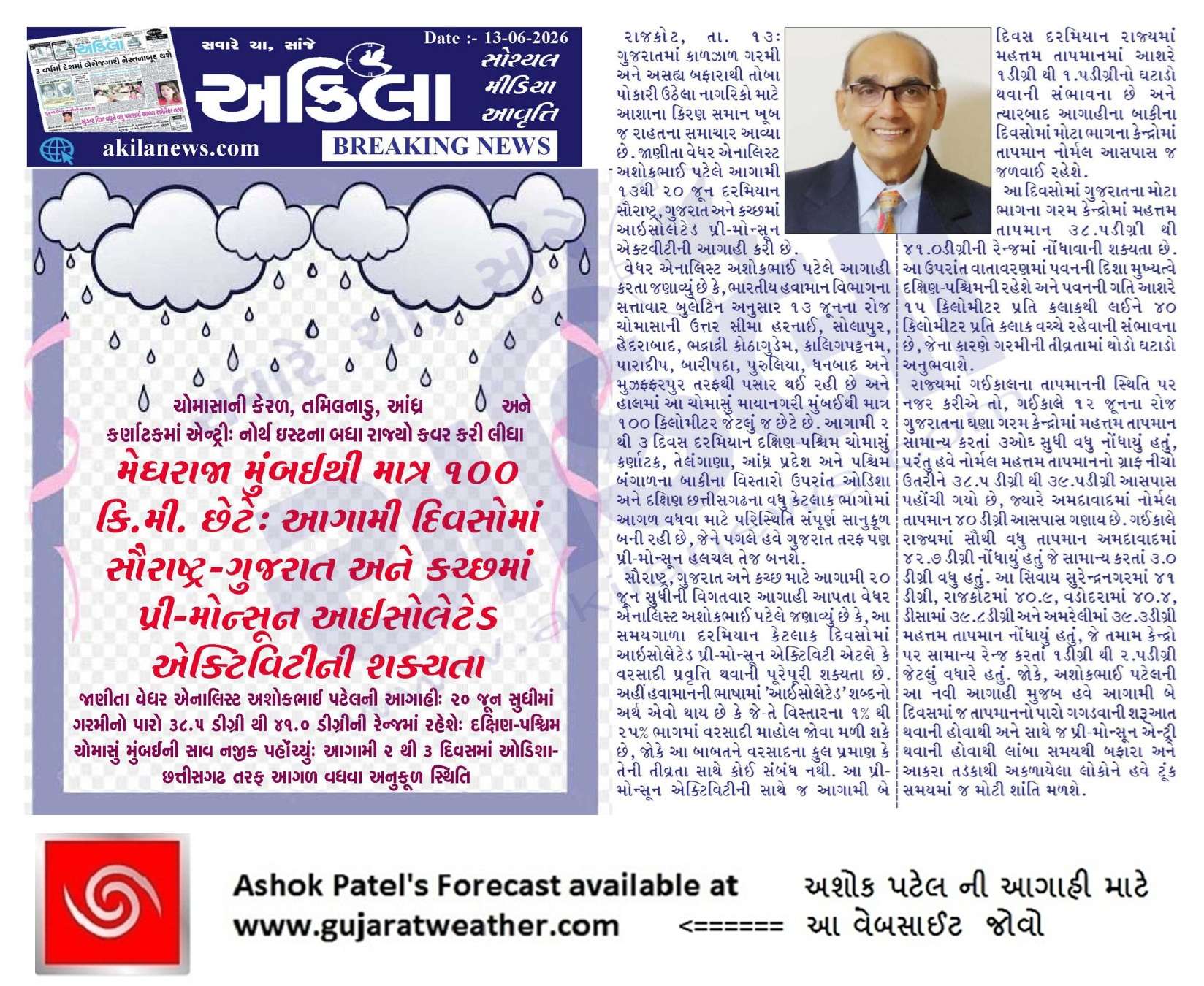
Forecast In Akila Daily Dated 13th June 2026
Forecast In Sanj Samachar Daily Dated 13th June 2026
Atiyare 15 min thi full japtu chalu thyu che road full bhina thi gya
જય શ્રી કૃષ્ણ સર ‘ આજે વહેલી સવારે સાડા ત્રણ વાગે એક ઝાપટુ અને સવારે સાડા પાંચ વાગે બીજું ઝાપટુ રોડ પલરે એવુ આવ્યુ હતુ ‘ અને અત્યારે આકાશ માં થોડોક કલર આપ્યો છે ‘ ઘાટા વાદળો ના ચોગઠા ગોઠવાય છે , જોઈએ બપોર પછી ક્યાં વરસાદ થાય છે
Ajje Akash ma chitri vadda joyu, aa positive sign chee.
Sir amuk peg ma tamari juni updet fari rahi che ne kheduto ne gumrah kare kharekhar a bav dukh thay ava loko je agahi ferve che
Aava loko ne samuhik ritey saamno karvo joiye.
Publik ne ger margey dori ne khotu nukhan karey chhe.
Sir atyar na samay ma Havaman ni agahi babate lokone tamara upar sauthi vadhu vishvas che evama tamara nam ane fota sathe agahi ape jethi loko vdhu germarge doray che. Hu to mara olkhita ne gujarat weather sivay biji koi agahi par dhyan na apava samjavu j chu. A rite badha jagruti felave to saru rahe
manso saheb ni websait mathi shikhi shiki ne potana manma mota havaman samji betha che.
Publik ne ger marge dorey chhe.
Keshod ma zapatu 7.45am
Modalo have 22 dt thi 28 thi 3 dt ma gujrat ma saro varsad thy jase ane 21 dt thi vatavaran pan sudhre che barobar ne sir
Aje Porbandar City Ma 4 thi 5 Zapta pdya Ane akho divas pavan sathe varsadi vatavrn rhyu Garmi mathi Rahat Models jota evu lage che coastal Areas ma Zaptao chalu rehse avnara divso ma
Gondal ma atyare kok kok chhata khare chhe
sir rajethan vaalu tndrarstom Gujarat shudhi avi shake
Gujarat border sudhi asar thati hoy chhe.
Multiple extended forecasts update nti sir
Every Thursday thaay chhe.
Porbandar City Ma Aje Bapore Fari Zordar Zaptu Road upr pani chalta thya Garmi mathi Thodik Rahat.
Imd Gfs a varshe accurate runs aaptu nathi…
Su Karan hoi shake
Good afternoon sir..sir aatyre pre monsoon activity ma Kyu model lagu pade ..GFS ke biju…ke pacchi other model ke mix combination.. answer apjo..sir
Varsad ke Pre-monsoon badhama badha model jovana
Sir, Model ni update jota haju to 15 divas ky khas bhare varsad jevu lagtu nathi
Samany reda japta k hadvo cotsal saurashtra & South Gujarat ma thay aevu lage che.
તારીખ: 16 જૂન 2026 આજની પરિસ્થિતિ ભારતીય હવામાન વિભાગ (IMD) અનુસાર મિડ-ડે બુલેટિન મુજબ: – નૈઋત્ય ચોમાસાની ઉત્તર સીમા (NLM) હાલ 18°N/60°E, 18°N/65°E, 18°N/70°E, હરનાઈ, સોલાપુર, હૈદરાબાદ, ભદ્રાચલમ, કોરાપુટ, ફુલબાની, રાંચી, જામુઈ, મુઝફ્ફરપુર અને 28.3°N/83°E પરથી પસાર થઈ રહી છે. – આગામી 4 થી 5 દિવસ દરમિયાન ચોમાસું તેલંગાણા, ઓડિશા, ઝારખંડ, બિહાર તથા છત્તીસગઢના કેટલાક વધુ ભાગોમાં આગળ વધવા માટે પરિસ્થિતિ અનુકૂળ છે. – સરેરાશ સમુદ્ર સપાટી પરની મોસમી ટ્રફ (Seasonal Trough) પંજાબથી હરિયાણા અને ઉત્તર પ્રદેશ મારફતે બિહાર સુધી યથાવત છે. – દક્ષિણ પંજાબ અને આસપાસ રહેલું ઉપરવાસી ચક્રવાતીય પરિભ્રમણ હવે હરિયાણા અને આસપાસ વિસ્તર્યું છે, જે સરેરાશ સમુદ્ર… Read more »
સર
મુંબઈ માં 20 જૂન થી પ્રિમોન્સુન & 23 થી
રેગ્યુલર ચોમાસું બેસે એવું વિવિધ મોડલો જોતા
આજ અંદાજ લાગે છે. આપ શ્રી નો શું અભિપ્રાય છે..
મને ખબર છે કે આપશ્રી લાંબા ગાળા નુ અનુમાન નથી આપતા.
જય દ્વારકાધીશ
IMD mujab 4-5 divas ma Maharashtra ma agad chalshe chomasu.
આજ ના બુલેટિન મા મહારાષ્ટ્ર ગાયબ છે
Monrning Bulletin mujab lakhel.
Miday ma Bulletin mathi Maharasthra gayab. Etle em samajvanu.
sir pn aaj to maharashtra nu name nathi
Monrning Bulletin mujab lakhel.
Miday ma Bulletin mathi Maharasthra gayab. Etle em samajvanu.
પોરબંદર શહેરમાં ચોમાસા ના પહેલા ઝાપટાં ની શુભ શરૂઆત આજે વાતાવરણ સારું લાગે છે.થોડોક મેળ પડી જાય તો વાવેતર માં જીવ આવી જાય
ચોમાસુ પવન કયા લેવલ માજોવાના
Surface thi 700 hPa sudhi
સાહેબ 850 થી 700, 600 hpa માં ભેજ સાથે સાથે સર્ક્યુલેશન પણ હોવું જોઈએને?
Yes.
Na hoy toe Tanker fakt zaapta naykhey jaay…moto varsad na hoy.
આજે વાતાવરણ માં ફેરફાર છે તેવું લાગે છે રાજકોટ
Sir aje jethi bij che vijdi thay 72 kadhe a vadilo ni maniyta che a su hakikat che
Te Paramparik Vara bhaiyio ne puchho.
એક દીવસ મા ગાજી ને વ્યો જાય તો
વર્ષો થી અમારી બાજુ ગામડામાં એક કહેવત છે કે હાથીયો કોલ આપે એટલે મગષર માં વાવણી થાય આ વખતે નક્કી થય જાહે જો 22/જુન પહેલા વાવણી થાય તો સાચું