Saurashtra & Kutch Rainfall Prospects Expected to Improve During 12th–16th September 2026 — Forecast for 9th–16th September 2026
સૌરાષ્ટ્ર અને કચ્છમાં 12થી 16 સપ્ટેમ્બર 2026 દરમિયાન વરસાદના સંજોગોમાં સુધારો થવાની શક્યતા — 9થી 16 સપ્ટેમ્બર 2026 માટેની આગાહી
Few parameters from IMD Bulletin — 9th September 2026:
- The western end of the Monsoon Trough is north of its normal position, while the eastern end is near its normal position at mean sea level.
- An upper-air cyclonic circulation lies over north Bay of Bengal & adjoining Bangladesh coast in the lower and middle tropospheric levels. Under its influence, a Low Pressure Area is likely to form over the North Bay of Bengal & neighbourhood around 10th September 2026.
- A trough runs from Rayalaseema to the Gulf of Mannar in the lower tropospheric levels.
- An upper-air cyclonic circulation lies over Saurashtra & neighbourhood in the lower tropospheric levels.
- An upper-air cyclonic circulation lies over north Haryana & neighbourhood in the lower tropospheric levels.
- The Western Disturbance as a cyclonic circulation lies over northwest Uttar Pradesh & neighborhood in the middle tropospheric levels.
Weather Forecast for Saurashtra, Gujarat & Kutch (9th–16th September 2026)
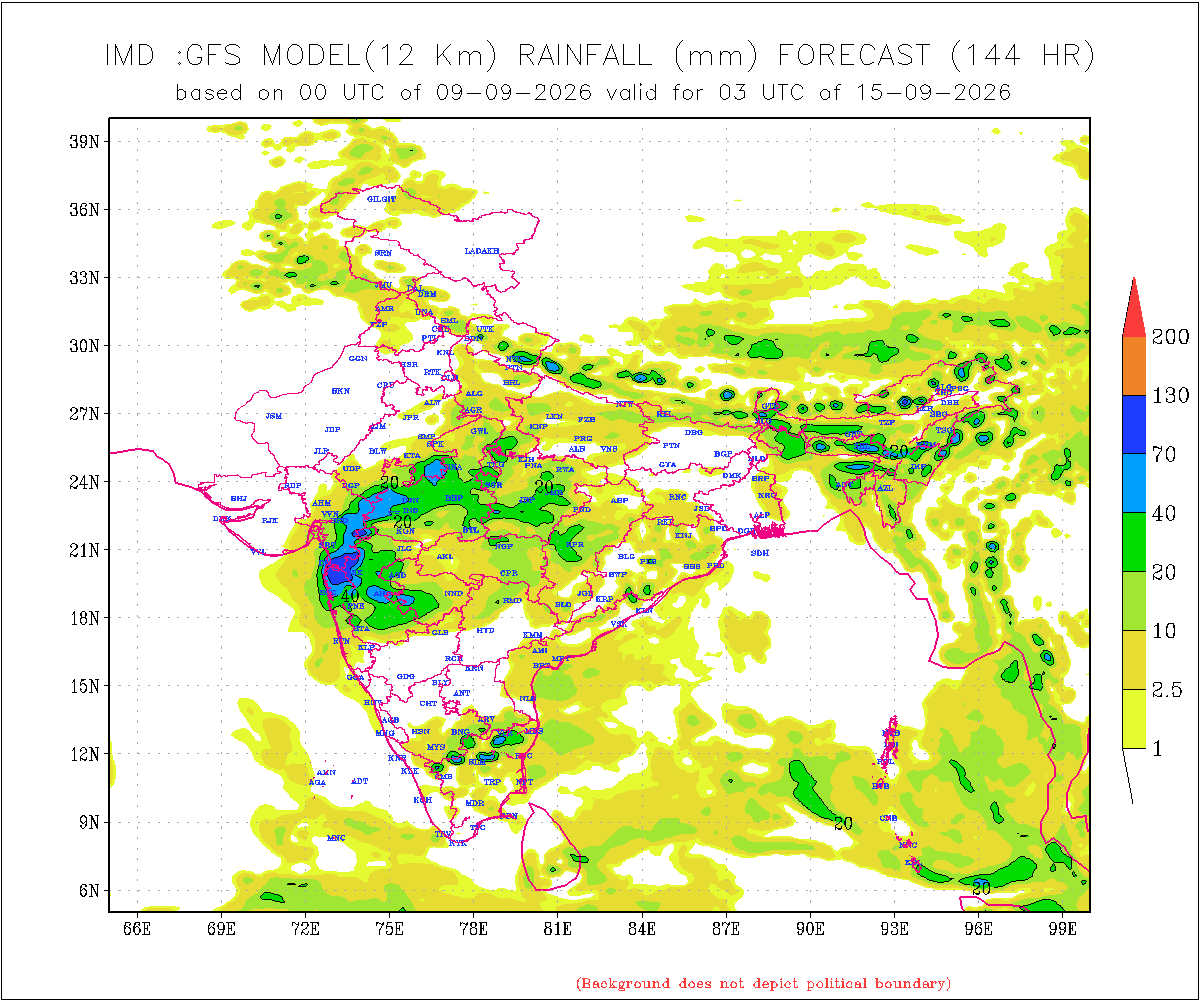
Overall: Rainfall prospects are expected to improve during the forecast period due to the upcoming Low Pressure Area and associated Upper Air Circulation (UAC) at various levels, tilting southwestward with height over Madhya Pradesh and adjoining Maharashtra areas.
There is a differing outcome in the IMD GFS output from the 09-09-2026 00 UTC run, as well as in the NOMADS GFS for the same run time. These models indicate considerably lower rainfall over Gujarat State compared to various other forecast models, including ECMWF, ICON and other international models.
The rainfall forecast given here is therefore higher than the current IMD GFS model outcome, based on various model guidance regarding the potential Low Pressure Area and its track along with Monsoon trough moving southwards towards normal.
Gujarat Region
- Rainfall: Scattered rainfall is likely over parts of Gujarat Region on different days, mainly during 12th–16th September.
- 50% of the area is expected to receive 20–35 mm of total rainfall during the forecast period.
- The remaining 50% of the area is expected to receive 35–75 mm of total rainfall during the forecast period.
- Isolated locations could receive more than 100 mm of total rainfall.
Saurashtra & Kutch
- Rainfall prospects over Saurashtra & Kutch are expected to improve during 12th–16th September 2026.
- Rainfall: Scattered rainfall is likely on different days of the forecast period, mainly during 12th–16th September.
- 50% of the area is expected to receive 25–50 mm of total rainfall during the forecast period.
- The remaining 50% of the area is expected to receive up to 25 mm of total rainfall during the forecast period.
- Isolated locations could receive more than 100 mm of total rainfall.
Note: When the Low Pressure Area develops over the Bay of Bengal and its initial location becomes established, the above forecast will be revisited if required.
Introducing: KOLA Interactive Rainfall Forecast Atlas
All India States and within each State up to District level Rainfall data is available. Select your State and subsequently all Districts will also be listed within your State in Alphabetical order. This data is based on IMD GFS Daily Precipitation Forecast for 1 to 10 days.
સૌરાષ્ટ્ર અને કચ્છમાં 12થી 16 સપ્ટેમ્બર 2026 દરમિયાન વરસાદના સંજોગોમાં સુધારો થવાની શક્યતા — 9થી 16 સપ્ટેમ્બર 2026 માટેની આગાહી
IMD બુલેટિન — 9 સપ્ટેમ્બર 2026ના કેટલાક મહત્વપૂર્ણ પરિબળો:
- મોન્સૂન ટ્રફનો પશ્ચિમ છેડો તેની સામાન્ય સ્થિતિથી ઉત્તર તરફ છે, જ્યારે તેનો પૂર્વ છેડો સમુદ્ર સપાટી પર તેની સામાન્ય સ્થિતિની નજીક છે.
- નીચલા અને મધ્ય ટ્રોપોસ્ફેરિક સ્તરે ઉત્તર બંગાળની ખાડી અને તેને અડીને આવેલા બાંગ્લાદેશના દરિયાકાંઠા વિસ્તારમાં ઉપરના વાતાવરણમાં ચક્રવાતી પરિભ્રમણ યથાવત્ છે. તેના પ્રભાવ હેઠળ 10 સપ્ટેમ્બર 2026ની આસપાસ ઉત્તર બંગાળની ખાડી અને આસપાસના વિસ્તારમાં લો પ્રેશર એરિયા રચાવાની શક્યતા છે.
- નીચલા ટ્રોપોસ્ફેરિક સ્તરે રાયલસીમાથી ગલ્ફ ઑફ મન્નાર સુધી ટ્રફ વિસ્તરેલો છે.
- નીચલા ટ્રોપોસ્ફેરિક સ્તરે સૌરાષ્ટ્ર અને આસપાસના વિસ્તારમાં ઉપરના વાતાવરણમાં ચક્રવાતી પરિભ્રમણ યથાવત્ છે.
- નીચલા ટ્રોપોસ્ફેરિક સ્તરે ઉત્તર હરિયાણા અને આસપાસના વિસ્તારમાં ઉપરના વાતાવરણમાં ચક્રવાતી પરિભ્રમણ યથાવત્ છે.
- મધ્ય ટ્રોપોસ્ફેરિક સ્તરે વેસ્ટર્ન ડિસ્ટર્બન્સ તરીકેનું ચક્રવાતી પરિભ્રમણ ઉત્તર-પશ્ચિમ ઉત્તર પ્રદેશ અને આસપાસના વિસ્તારમાં યથાવત્ છે.
સૌરાષ્ટ્ર, ગુજરાત અને કચ્છ માટે હવામાન આગાહી (9થી 16 સપ્ટેમ્બર 2026)
એકંદરે: આગાહી સમયગાળા દરમિયાન વરસાદની સંભાવનાઓમાં સુધારો થવાની શક્યતા છે. તેનું મુખ્ય કારણ આગામી લો પ્રેશર એરિયા અને વિવિધ સ્તરે તેની સાથે સંકળાયેલું અપર એર સાયક્લોનિક સર્ક્યુલેશન (UAC) છે, મધ્ય પ્રદેશ અને તેને અડીને આવેલા મહારાષ્ટ્રના વિસ્તારો પર, જે વધતી ઉંચાઈએ દક્ષિણ પશ્ચિમ તરફ ઝુકે.
09-09-2026 00 UTCના IMD GFS આઉટપુટ તેમજ સમાન રન સમયના NOMADS GFSમાં વરસાદના પરિણામમાં તફાવત જોવા મળે છે. આ મોડેલો અન્ય વિવિધ આગાહી મોડેલો, જેમાં ECMWF, ICON અને અન્ય આંતરરાષ્ટ્રીય મોડેલોનો સમાવેશ થાય છે, તેની સરખામણીએ GFS ગુજરાત રાજ્યમાં નોંધપાત્ર રીતે ઓછો વરસાદ દર્શાવે છે.
આથી અહીં આપવામાં આવેલી વરસાદની આગાહી હાલના IMD GFS મોડેલના પરિણામ કરતાં વધુ છે. આ આગાહી સંભવિત લો પ્રેશર એરિયા અને તેની ટ્રેક અંગેના વિવિધ મોડેલ માર્ગદર્શન, તેમજ મોન્સૂન ટ્રફના દક્ષિણ તરફ ખસીને તેની સામાન્ય સ્થિતિ તરફ જવાના વલણને ધ્યાનમાં રાખીને કરવામાં આવી છે.
ગુજરાત રિજન
- વરસાદ: ગુજરાત રિજનના કેટલાક વિસ્તારોમાં અલગ-અલગ દિવસોમાં છૂટાછવાયા વરસાદની શક્યતા છે, ખાસ કરીને 12થી 16 સપ્ટેમ્બર દરમિયાન.
- આગાહી સમયગાળા દરમિયાન 50% વિસ્તારમાં કુલ 20–35 મિમી વરસાદ થવાની શક્યતા છે.
- બાકીના 50% વિસ્તારમાં કુલ 35–75 મિમી વરસાદ થવાની શક્યતા છે.
- આઇસોલેટેડ સ્થળોએ કુલ વરસાદ 100 મિમીથી વધુ થઈ શકે છે.
સૌરાષ્ટ્ર અને કચ્છ
- 12થી 16 સપ્ટેમ્બર 2026 દરમિયાન સૌરાષ્ટ્ર અને કચ્છમાં વરસાદની સંભાવનાઓમાં સુધારો થવાની શક્યતા છે.
- વરસાદ: આગાહી સમયગાળા દરમિયાન અલગ-અલગ દિવસોમાં છૂટાછવાયા વરસાદની શક્યતા છે, ખાસ કરીને 12થી 16 સપ્ટેમ્બર દરમિયાન.
- આગાહી સમયગાળા દરમિયાન 50% વિસ્તારમાં કુલ 25–50 મિમી વરસાદ થવાની શક્યતા છે.
- બાકીના 50% વિસ્તારમાં કુલ 25 મિમી સુધી વરસાદ થવાની શક્યતા છે.
- આઇસોલેટેડ સ્થળોએ કુલ વરસાદ 100 મિમીથી વધુ થઈ શકે છે.
નોંધ: બંગાળની ખાડી પર લો પ્રેશર એરિયા રચાય અને તેનું પ્રારંભિક સ્થાન સ્પષ્ટ થાય ત્યારબાદ, જરૂર જણાય તો ઉપરોક્ત આગાહીની પુનઃસમીક્ષા કરવામાં આવશે.
પરિચય: KOLA Interactive Rainfall Forecast Atlas
ભારતના તમામ રાજ્યો તેમજ દરેક રાજ્યના જિલ્લા સ્તર સુધીના વરસાદના અનુમાન ઉપલબ્ધ છે. તમારું રાજ્ય સિલેક્ટ કરો અને પછી દરેક ડીસ્ટ્રીકટ ના આંકડા ઉપલબદ્ધ થશે અલ્ફાબેટિક ક્રમ માં. આ માહિતી IMD GFS મોડેલના 1 થી 10 દિવસના દૈનિક વરસાદ (Daily Precipitation)ના ફોરકાસ્ટ અનુમાન પર આધારિત છે.
Caution: Please refer/rely on IMD/RSMC Bulletins/Advisories for Storms & Weather related matter.
સાવચેતી: સ્ટોર્મ કે હવામાન અંગે ની માહિતી માટે ભારતીય હવામાન ખાતા/ગવર્મેન્ટ ના બુલેટીન/સુચના પર નિર્ભર રહેવું.
Read Comment Policy – કમેન્ટ માટે માર્ગદર્શન વાંચો
How To Upload Profile Picture For WordPress – વર્ડપ્રેસ માં પ્રોફાઈલ પિક્ચર કેમ રાખવું
Forecast In Akila Daily Dated 9th September 2026

Pending Forecast In Sanj Samachar Daily Dated 9th September 2026
KOLA Interactive Rainfall Forecast Atlas