Current Weather Conditions on 27th May 2018
As per IMD:
Southwest Monsoon further advanced into some parts of South Arabian Sea and Maldive-Comorin area; some more parts of south Bay of Bengal, Andaman & Nicobar Islands and Andaman Sea. The Northern Limit of Monsoon (NLM) passes through Lat. 5°N/Long. 70°E, Lat. 5°N/Long. 75°E, Lat.6°N/Long. 80°E, Lat. 8°N/Long. 85°E, Lat. 11°N/Long 90°E, Mayabandar, Lat.15°N/Long. 95°E and Lat.17°N/Long. 98°E.
Conditions are favorable for further advance of Southwest Monsoon into some parts of South Arabian Sea, remaining parts of Comorin-Maldives area; some parts of Kerala and Tamilnadu during next 48 hours; and into some more parts of South Bay of Bengal, remaining parts of Andaman Sea and Andaman & Nicobar Islands during next 24 hours.
IMD Advance Of Southwest Monsoon Map
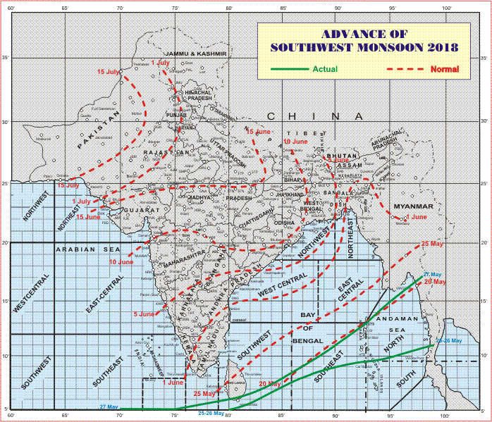
સૌથી ઉપર ની લીલી લીટી ના છેડે જે તારીખ હોઈ તે તારીખે લીટી ની નીચે ના ભાગ માં બધે ચોમાસું પોંચી ગયું છે તેમ સમજવું.
લાલ ત્રુટક લીટી જે તે વિસ્તાર માં નોર્મલ ચોમાસું બેસવાની તારીખ દર્શાવે છે
The date shown at the end of green line shows that the Southwest Monsoon has set in over areas below the green line on that date.
The red dashed line shows the normal date of onset of Southwest Monsoon over various regions
હાલ ની પરિસ્થિતિ અને નિચોડ:
દક્ષિણ પશ્ચિમ ચોમાસુ માલદિવ્સ કોમોરીન ના અમૂક ભાગો માં , આંદામાન અને નિકોબાર ટાપુઓ; આંદામાન દરિયા અને દક્ષિણ બંગાળ ની ખાડી ના થોડા વધુ ભાગો માં આગળ ચાલ્યું.
આવતા બે ત્રણ દિવસ માં ચોમાસુ કેરળ અને તામિલનાડુ પહોંચે તેવી શક્યતા છે.
દક્ષિણ પૂર્વ અરબી સમુદ્ર માં એક લો પ્રેસર થયું છે કેરળ/કર્ણાટક ના કિનારા નજીક છે. વેલ માર્કંડ થવાની શક્યતા છે.
Other Weather Conditions:
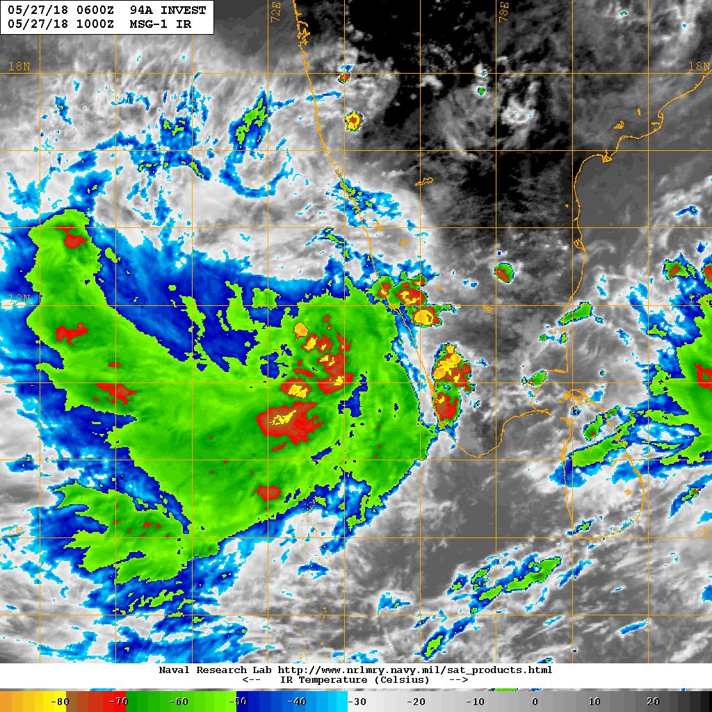
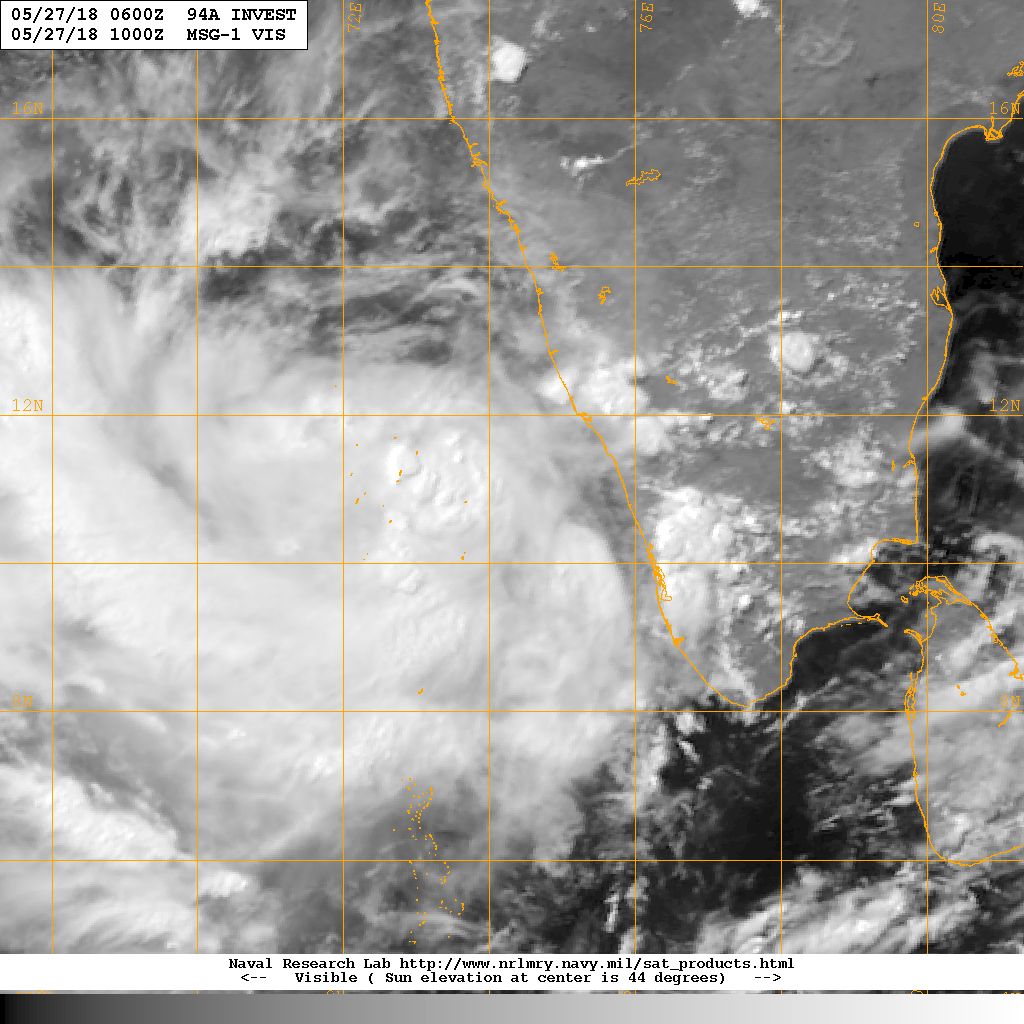
The broad Upper Air Cyclonic Circulation over Southern Peninsula has descended to mean sea level as a Low Pressure area over Southeast Arabian sea off Kerala/ Karnataka coasts with associated Cyclonic Circulation extending up to 7.6 km above mean sea level. It is expected to become a Well Marked Low Pressure area in a day or two. This System is being monitored by JTWC as 94A.INVEST
NRL IR Satellite Image of 94A.INVEST ( Low Pressure)
on 27th May 2018 @ 1000 UTC ( 03.30 pm. IST)
NRL Visible Satellite Image of 94A.INVEST ( Low Pressure)
on 27th May 2018 @ 1000 UTC ( 03.30 pm. IST)
Caution: Please refer/rely on IMD/RSMC Bulletins/Advisories for Storms & Weather related matter.
સાવચેતી:
સ્ટોર્મ કે હવામાન અંગે ની માહિતી માટે ભારતીય હવામાન ખાતા/ગવર્મેન્ટ ના બુલેટીન/સુચના પર નિર્ભર રહેવું.