Current Weather Conditions on 29 September 2015 @ 08.30 pm. IST
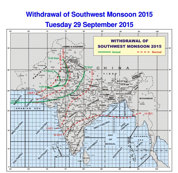
The Southwest Monsoon has further withdrawn from remaining parts of Rajasthan, Punjab, Haryana, Chandigarh & Delhi, entire Jammu & Kashmir, Himachal Pradesh, Uttarakhand, most parts of West Uttar Pradesh and some parts of West & North Madhya Pradesh, entire Kutch, most parts of North Gujarat and some parts of adjoining Saurashtra and parts of North Arabian sea.
The withdrawal line of southwest monsoon passes through Dharchula, Etawah, Guna, Ratlam, Ahmadabad, Dwarka, Lat.22.0°N/Long. 65.0°E and Lat.22.0°N/Long. 60.0°E.
IMD Map showing the Withdrawal of Southwest Monsoon till 29th September 2015.
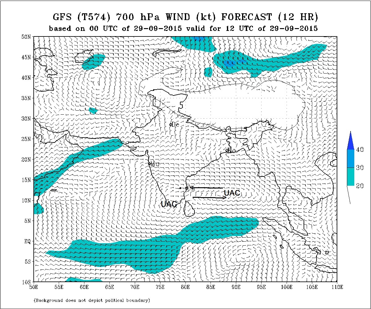
The Upper Air Cyclonic Circulation over the Bay of Bengal near Andaman & Nicobar Islands extending up to Mid-Tropospheric level persists. Under its influence a Low Pressure area could form over Bay Of Bengal and neighborhood.
There is an Upper Air Cyclonic Circulation over Kerala and adjoining Arabian Sea extending between 1.5 km & 3.1 km above mean sea level.
There is an East-West shear zone roughly along Latitude 13.0°N extending between 1.5 & 3.1 km above mean sea level.
The Western Disturbance as an Upper Air trough in the Mid-Tropospheric Westerlies roughly along Longitude 65°E and North of Latitude 30°N.
The two UAC and the East West shear zones are marked on top of IMD GFS (T574) 700 hPa chart as shown below.
IMD GFS (T574) 700 hPa Wind Forecast Valid 12 UTC 29th September 2015
Forecast: 29th September to 5th October 2015
Under the influence of the UAC over the Bay Of Bengal a Low Pressure area could develop over BOB.
Saurashtra, Gujarat & Kutch:
Mostly clear weather during the forecast period with no chance of any meaningful rainfall. The Maximum Temperature is expected to increase from tomorrow and by 1st October it is expected to be above normal at some places of Saurashtra, Gujarat & Kutch.
અપડેટ તારીખ 29 સપ્ટેમ્બર 2015 @ રાત્રે 8.30 વાગ્યે:
દક્ષીણ પશ્ચિમ ચોમાસુ રાજસ્થાન, પંજાબ હરયાણાના બાકી ના ભાગો માંથી તેમજ સમગ્ર ચંદીગઢ , દિલ્હી, જમ્મુ કાશ્મીર, હિમાચલ પ્રદેશ અને ઉત્તરાખંડ, પશ્ચિમ યુપી ના મહત્તમ ભાગો માંથી તેમજ પશ્ચિમ અને ઉત્તર એમ.પી. ના અમૂક ભાગો માંથી વિદાય લીધી છે. તેવીજ રીતે દક્ષીણ પશ્ચિમ ચોમાસા એ સમગ્ર કચ્છ, ઉત્તર ગુજરાત ના મહત્તમ ભાગો અને લાગુ સૌરાષ્ટ્ર ના અમૂક ભાગો માંથી વિદાય લીધી છે.
દક્ષીણ પશ્ચિમ ચોમાસા ની વિદાય રેખા નકશા માં બતાવેલ છે. 29 તારીખ લખેલ લીલી લીટી ની ઉત્તરે બધા વિસ્તારો માંથી ચોમાસા એ વિદાય લીધી તેમ સમજવાનું.
એક UAC બંગાળની ખાડી માં અંદામાન આસપાસ છે તે ‘UAC’ થી બતાવેલ છે. તેની અસર થી લો પ્રેસર થવાની શક્યતા છે.
બીજું UAC કેરલા અને લાગુ અરબી સમુદ્ર ઉપર છે તે ‘UAC’ થી બતાવેલ છે.
પૂર્વ પશ્ચીમ નું શિયર ઝોન Latitude 13.0°N ઉપર છે, જે એરો થી બતાવેલ છે.
વેસ્ટર્ન ડિસ્ટર્બન્સ હાલ અપર ટ્રફ તરીખે Longitude 65.0°E and North of latitude 30.0°N ઉપર છે.
સૌરાષ્ટ્ર, ગુજરાત અને કચ્છ: તારીખ 29 થી સપ્ટેમ્બર થી 5 ઓક્ટોબર;
આગાહી સમય માં કોઈ નોંધ પાત્ર વરસાદ ની શક્યતા નથી. આવતી કાલ તારીખ 30 થી ગરમી આંશિક વધશે અને તારીખ 1 લી ઓક્ટોબર થી 4 તારીખ સુધી મહત્તમ તાપમાન અમૂક સેન્ટર માં નોર્મલ થી ઊંચું જશે.
Weather Forecast In Akila Daily Dated 30th September 2015

Scroll Up