Current Weather Conditions on 15th September 2015 @ 9.00 am. IST
Weather Conditions:
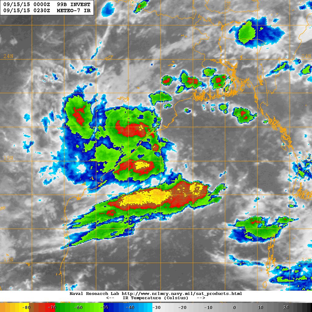
The Low Pressure area over Westcentral & adjoining Northwest Bay of Bengal has strengthened to a Well Marked Low Pressure with mean sea level pressure of 999 mb. The Associated Upper Air Cyclonic Circulation extending upto 7.6 km above mean sea level persists.
This System is being monitored by JTWC as 99B.INVEST from 13th September 1430 UTC.
The shear zone roughly along Latitude 16.0°N between 2.1 & 7.6 km above mean sea level persists.
NRL Satellite IR Image on 15th September 2015 @ 0230 UTC
There has been scattered showers, light/medium rainfall over many parts of Saurashtra & some parts of Gujarat and few places in Kutch. Some isolated exceptionally heavy rain has also been reported over few places in Saurashtra during three four days.
Forecast: 15th to 21st September 2015
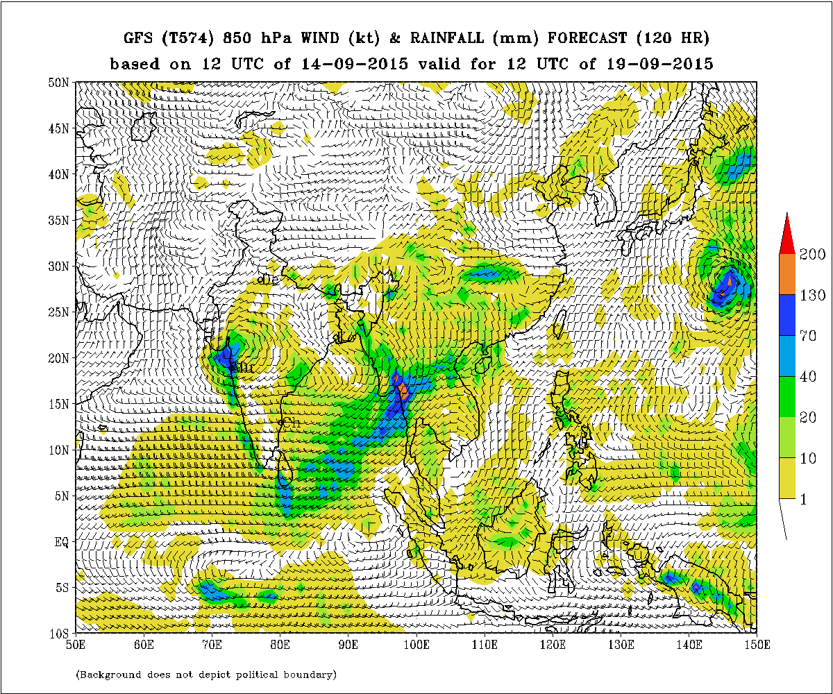
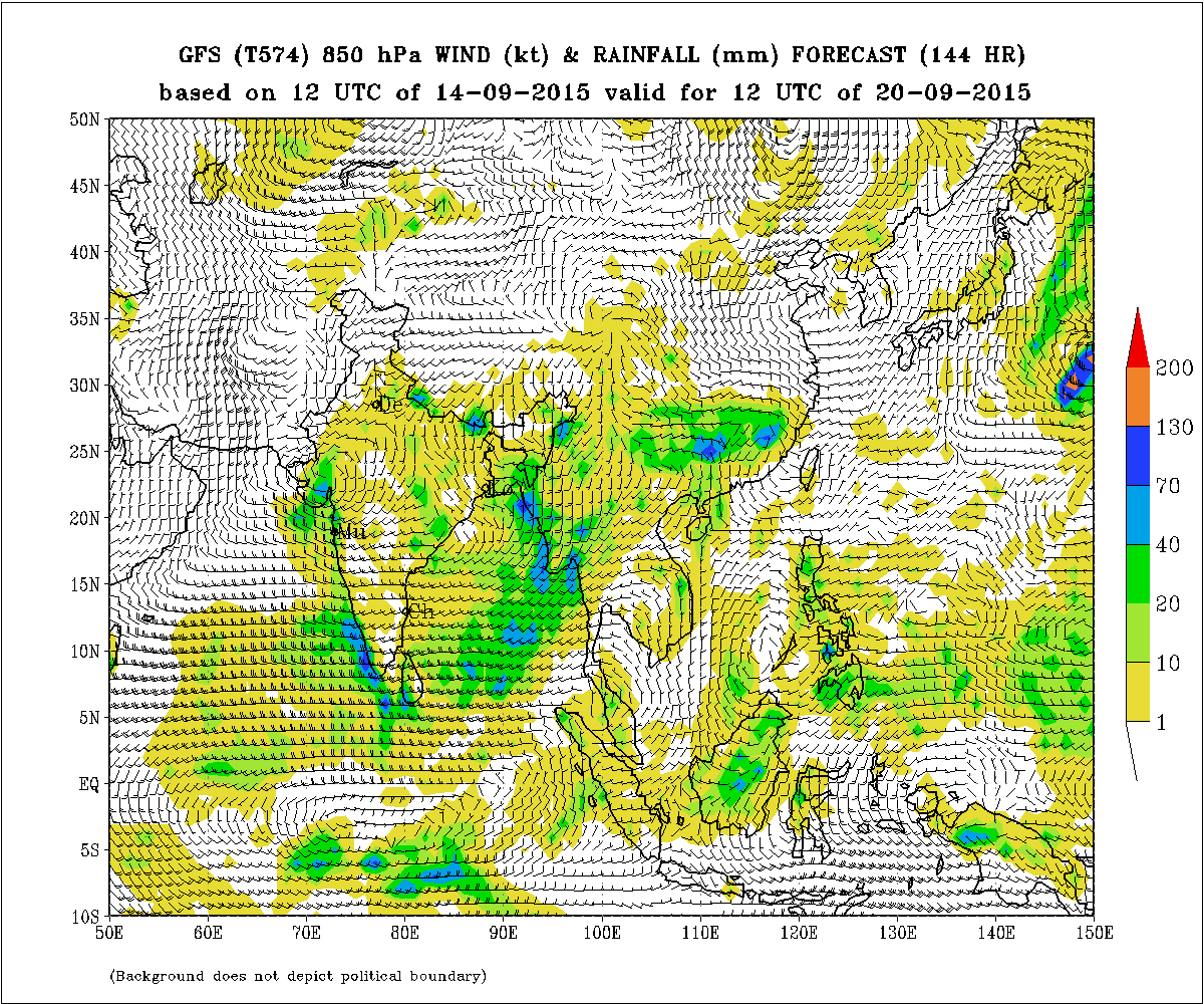
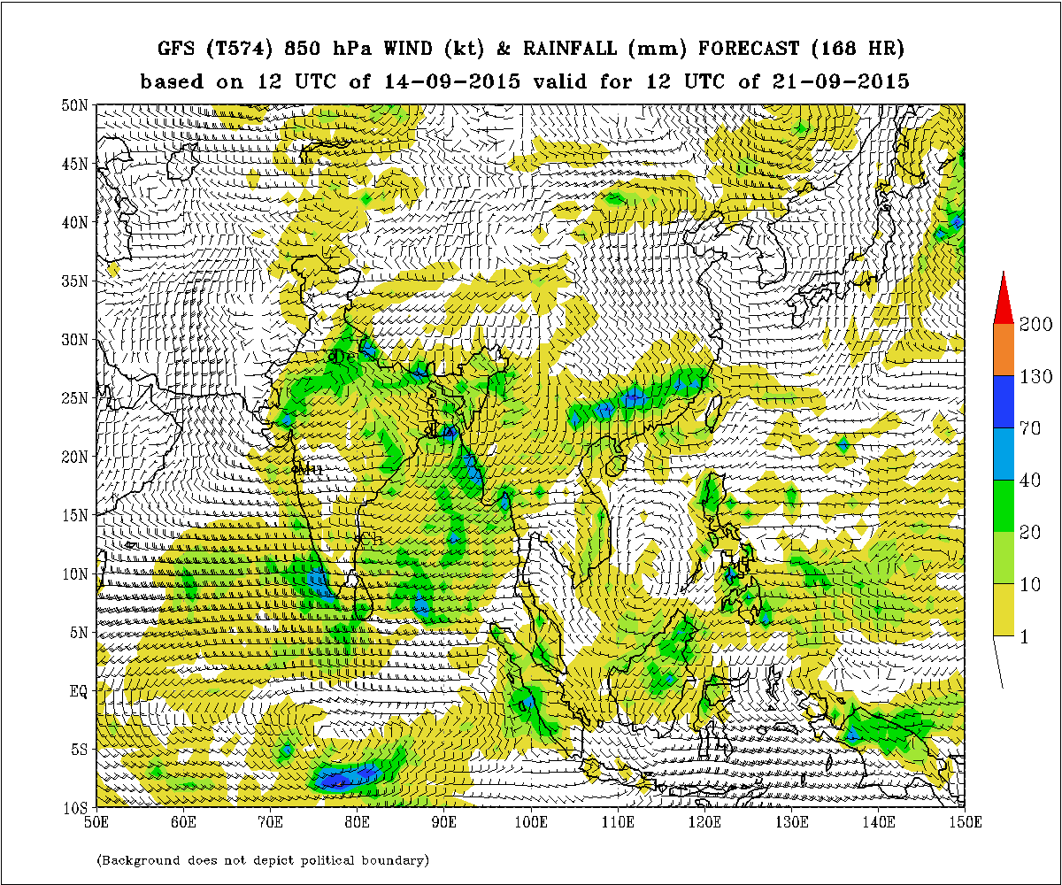
The Well Marked Low Pressure is expected to remain close to the Andhra/Odisha coast for one more day and as per GFS subsequently expected to track inland over land West Northwest direction and reach Maharashtra on 18th September and by 19th nearby Maharashtra & Gujarat areas. The System expected to be in the vicinity of Saurashtra, Gujarat and nearby Northeast Arabian Sea on 20th September. The ECMWF Forecast model takes the System towards M.P. and Central & North Gujarat.
Saurashtra, Kutch & Gujarat:
Forecast 15th to 18th September:
Scattered showers or light rain over parts of Saurashtra & Gujarat with medium rain over isolated places. The quantum of rainfall will be less than last four days in Saurashtra. However, South Gujarat & Central Gujarat could get some benefit from the peripheral clouding pertaining to the Low Pressure in the Bay of Bengal.
Kutch: No or very little rain for the area.
Under the influence of the Bay of Bengal System coming near Maharashtra & then near Gujarat & Saurashtra, there will be widespread rain during 19th to 21st September over Saurashtra, Gujarat & Kutch. The quantum of this rain is dependent on the final track of the System from the Bay of Bengal and hence it will be updated by 17th September. Yet, IMD 850 hPa & Precipitation maps are given for 19th, 20th & 21st September as an estimate of precipitation forecast of that period.
Monsoon is not yet over for Saurashtra, Gujarat & Kutch.
IMD GFS (T574) 850 hPa Winds (kt) & Rainfall (mm)
valid for 12 UTC 19th September 2015
IMD GFS (T574) 850 hPa Winds (kt) & Rainfall (mm)
valid for 12 UTC 20th September 2015
IMD GFS (T574) 850 hPa Winds (kt) & Rainfall (mm)
valid for 12 UTC 21st September 2015
તારીખ 15 સપ્ટેમ્બર 2015 સવારે 9.00 વાગ્યે
મધ્ય પશ્ચિમ અને લાગુ ઊતર પશ્ચિમ બંગાળ ની ખાડી માં જે લો પ્રેસર હતું તે મજબૂત થઇ ને વેલ માર્કડ લો પ્રેસર માં પરિવર્તિત થયું છે. તેના અનૂસંગિક અપર એર સાયક્લોનિક સર્ક્યુંલેસન છે 7.6 કિમી ની ઊંચાઈ સુધી ફેલાયેલ છે.
JTWC આ સીસ્ટમ ને 99B.INVEST તરીખે મોનીટર કરે છે.
પૂર્વ પશ્ચિમ ના સામ સામા પવનો (પૂર્વ-પશ્ચિમ) Latitude 16.0°N ઉપર 2.1 કિમી થી 7.6 કિમી ની ઊંચાયે ફેલાયેલ છે.
સૌરાષ્ટ્ર, કચ્છ અને ગુજરાત :
તારીખ 15 સપટેમ્બર થી 21 સપટેમ્બર 2015
છેલા ત્રણ ચાર દિવસ માં સૌરાષ્ટ્ર અને ગુજરાત માં ઝાપટા, હળવો મધ્યમ વરસાદ પડેલ તેમજ સૌરાષ્ટ્ર ના અમૂક સેન્ટરો માં ભારે વરસાદ થયેલ છે. કચ્છ ના એકલ દોકલ સેન્ટર માં વરસાદ ના રીપોર્ટ છે.
તારીખ 15 થી 18 સપટેમ્બર સુધી અંશત વાદળ છાયું વાતાવરણ રહેશે. આગાહી સમય માં અમૂક દિવસે ઝાપટા, હળવો /મધ્યમ વરસાદ ની શક્યતા છે જેની માત્ર અગલા ચાર દિવસ કરતા સૌરાષ્ટ્ર માં ઓછી રહેશે। જોકે દક્ષીણ ગુજરાત અને મધ્ય ગુજરાત માં બંગાળ ની સીસ્ટમ ના પૂછડિયા વાદળો થી અમૂક દિવસે થોડો ફાયદો રહેશે.
કચ્છ: તારીખ 15 થી 18 સપ્ટેમ્બર માં કચ્છ માં ખાસ કઈ વરસાદ ની શક્યતા નથી અથવા ઓછી.
બંગાળી ખાડી ની સીસ્ટમ એકાદ દિવસ આન્ધ્ર/ઓડીશા ના દરિયા નજીક રહેશે અને ત્યાર બાદ જમીન ઉપર આવી અને GFS મૂજબ પશ્ચિમ ઊત્તર પશ્ચિમ બાજુ ગતિ કરશે. તારીખ 18 સપ્ટેમ્બર સુધીમાં મહારાષ્ટ્ર ઉપર હશે અને તારીખ 19 સપ્ટેમ્બર ના મહારાષ્ટ્ર/ગુજરાત નજીક હશે. આ સીસ્ટમ તારીખ 20 ના ગુજરાત/સૌરાષ્ટ્ર અને લાગુ અરબી સમુદ્ર નજીક હશે તેવું અનુમાન ફોર્કાસ્ટ મોડેલો દર્શાવે છે.
ECMWF મૂજબ એમપી અને મધ્ય ગુજરાત અને ઊત્તર ગુજરાત બાજુ સીસ્ટમ જાય તેવો ફોરકાસ્ટ ટ્રેક બતાવે છે.
બંગાળ ની સીસ્ટમ મહારાષ્ટ્ર તેમજ ગુજરાત અને સૌરાષ્ટ્ર નજીક આવતી હોઈ તેની અસર થી તારીખ 19 થી 21 દરમિયાન સૌરાષ્ટ્ર ગુજરાત અને કચ્છ માં સાર્વત્રિક વરસાદ થાય તેવા સંજોગો થયા છે. વરસાદ ની માત્રા નું અનુમાન 17 તારીખ ના અપડેટ માં આવશે. તેમ છતાં પ્રાથમિક અંદાજ માટે IMD ના 850 hPa ના પવન અને વરસાદ ની માત્રા ના નકશા તારીખ 19 થી 21 સપ્ટેમ્બર માટે આપેલ છે.
સૌરાષ્ટ્ર, ગુજરાત અને કચ્છ માટે ચોમાસું હજુ પૂરું નથી થયું.
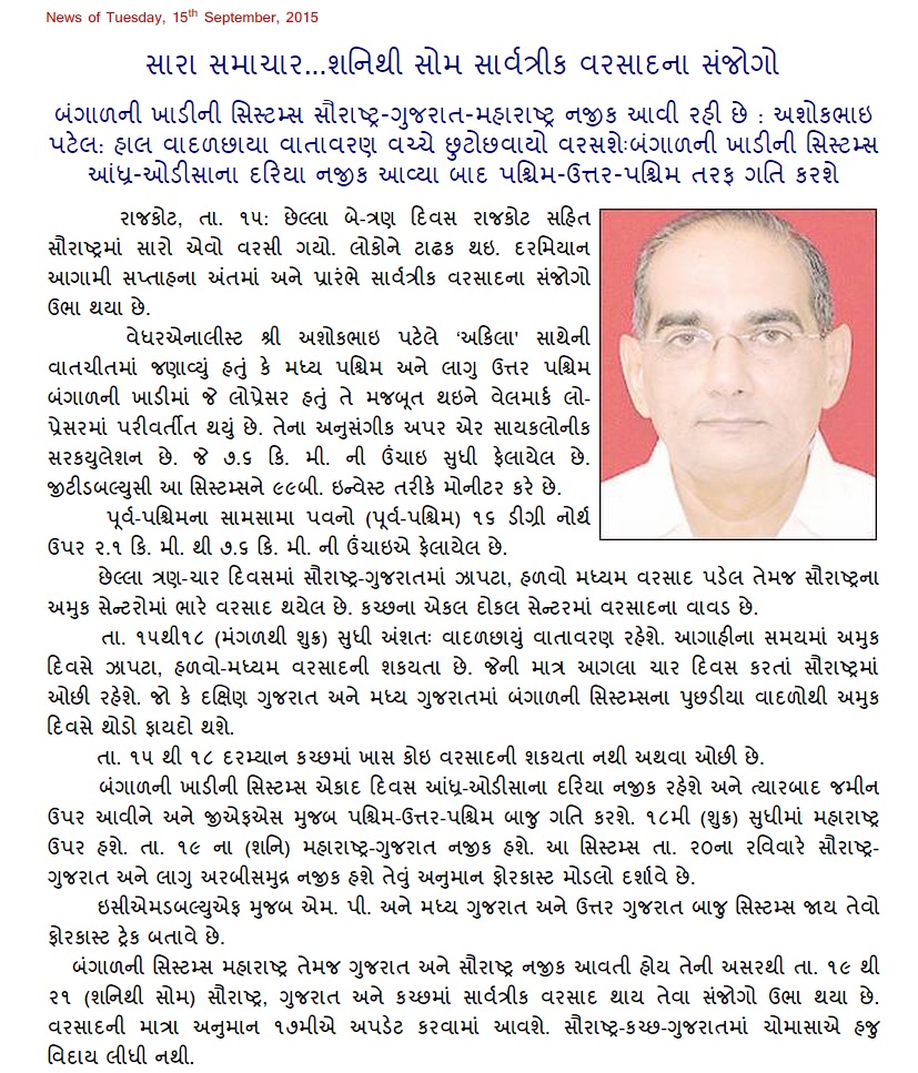
Weather Forecast In Akila Daily Dated 15th September 2015
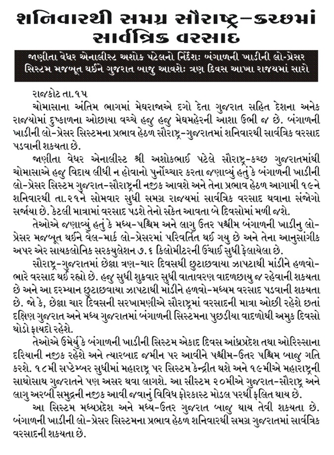
Weather Forecast In Sanj Samachar Dated 15th September 2015
Scroll Up