Current Weather Conditions on 9th June 2015 @ 11.00 am. IST
“ASHOBAA” નામ નું વાવાઝોડું મધ્ય પૂર્વ અરબી સમુદ્ર માંથી હવે આજે ઊત્તર પૂર્વ અરબી સમુદ્ર માં પ્રવેશ્યું. હાલ વાવાઝોડા નું કેન્દ્ર દ્વારકા થી 500 કિમી પશ્ચિમ દક્ષીણ પશ્ચિમે છે. આ વાવાઝોડા ના અનૂસંગિક ઘટ્ટ વાદળ સમૂહો છે તે સીસ્ટમ સેન્ટર થી મુખ્યત્વે પશ્ચિમે છે એટલે આ સીસ્ટમ ઓમાન તરફ વધુ હોઈ તેવું ઇન્સેટ માં લાગે છે. આજ રાત્રે આ સીસ્ટમ ઊત્તર પશ્ચિમ અરબી સમુદ્ર માં પ્રવેશ શે. મતલબ કે આ સીસ્ટમ ક્રમશ સૌરાષ્ટ્ર ના દરિયા કિનારા થી દૂર જશે તેવો અનુમાન છે. પવન 85 કિમી (1 મિનીટ ની શરેરાશ મૂજબ ) અને સેન્ટ્રલ પ્રેસર 989 મિલીબાર છે. આ સીસ્ટમ હજુ મજબૂત બની શકે છે તેવો અંદાજ છે.
આ સીસ્ટમ અને ચોમાસું વાદળો અલગ પડી ગયા છે માટે ચોમાસા ને આગળ ચાલવા માટે સાનૂકૂળ પરિસ્થિતિ છે. 24 કલાક માં ચોમાસું મધ્ય પૂર્વ અરબી સમુદ્ર તેમજ બંગાળ ની ખાડી ના અમૂક ભાગ અને દક્ષીણ ભારત ના રાજ્યો ના થોડા વધુ વિસ્તાર માં આગળ ચાલશે.
સૌરાષ્ટ , ગુજરાત અને કચ્છ ને એક બે દિવસ છૂટો છવાયો વરસાદ નો લાભ આ સીસ્ટમ ના પૂછડિયા વાદળા થી મળશે. ત્યાર બાદ પ્રિ મોન્સૂન એક્ટીવીટી થી તારીખ 14 સુધી સૌરાષ્ટ્ર, ગુજરાત અને કચ્છ ને થોડો ઘણો ફાયદો થશે. સૌરાષ્ટ્ર , ગુજરાત અને કચ્છ માં બેઠું નથી.
સુચના: માટે “અમારા વિસ્તાર માં ક્યારે અને કેટલો વરસાદ પડશે?” તેવા સવાલો પૂછવા નહિ અને તે પ્રશીધ્ધ નહિ થાય.
TROPICAL CYCLONE ADVISORY RSMC – TROPICAL CYCLONES, NEW DELHI
TROPICAL STORM ‘ASHOBAA’ ADVISORY NO.EIGHT ISSUED AT 0300 UTC OF 9 JUNE 2015 BASED ON 0000 UTC CHARTS. THE CYCLONIC STORM (ASHOBAA) OVER EASTCENTRAL ARABIAN SEA MOVED IN A NORTH-NORTHWESTERLY DIRECTION DURING PAST 12 HOURS AND LAY CENTRED AT 0000 UTC OF 9 JUNE 2015 NEAR LATITUDE 20.00 N AND LONGITUDE 65.00 E, ABOUT 830 KM WEST OF MUMBAI (43003), 570 KM WEST-SOUTHWEST OF VERAVAL (42909), 640 KM EAST-SOUTHEAST OF SUR (41268) (OMAN) AND 800 KM EAST-SOUTHEAST OF MUSCAT (41256) (OMAN). THE SYSTEM WOULD MOVE NORTH-NORTHWESTWARDS AND INTENSIFY FURTHER INTO A SEVERE CYCLONIC STORM DURING NEXT 24 HOURS AND IT WOULD MOVE NORTHWESTWARDS THEREAFTER. ACCORDING TO SATELLITE IMAGERIES, THE INTENSITY OF THE SYSTEM IS T 2.5. ASSOCIATED BROKEN LOW AND MEDIUM CLOUDS EMBEDDED WITH INTENSE TO VERY INTENSE CONVECTION IS SEEN OVER THE AREA BETWEEN LATITUDE 16.0 0 NORTH TO 22.00 NORTH, LONGITUDE 59.0 0 EAST TO 66.0° EAST. THE LOWEST CLOUD TOP TEMPERATURE (CTT) IS ABOUT -92 0 C. MAXIMUM SUSTAINED SURFACE WIND SPEED IS ESTIMATED TO BE ABOUT 35 KNOTS GUSTING TO 45 KNOTS AROUND THE SYSTEM CENTRE. THE STATE OF THE SEA IS VERY ROUGH AROUND THE SYSTEM CENTRE. THE ESTIMATED CENTRAL PRESSURE IS ABOUT 992 HPA.
Cyclonic Storm “ASHOBAA” has crossed over to North East Arabian Sea from East Central Arabian Sea. The System is now tracking North West and by night of 9th June it is expected to cross over to the Northwest Arabian Sea. There is a possibility of further intensification during the next 24 hours. The dense clouding associated with this System are mainly located to the West of the System center compared to the East, hence it looks as if the System is more towards Oman as compared to Saurashtra coast. The System center was 500 Kms. West Southwest from Dwarka,( Gujarat, India) in the morning.
The Monsoon clouding are now dis-associated from the Cyclonic Storm ‘ASHOBAA” and hence conditions are favorable for further advancement of Southwest Monsoon over parts of Central Arabian Sea , parts of Bay of Bengal and some more parts of South India & Konkan.
Saurashtra, Gujarat & Kutch: Scattered rainfall due to the effects of the Cyclonic activity for a day or two and then it will continue for few more days and the it will continue as pre-monsoon activity.
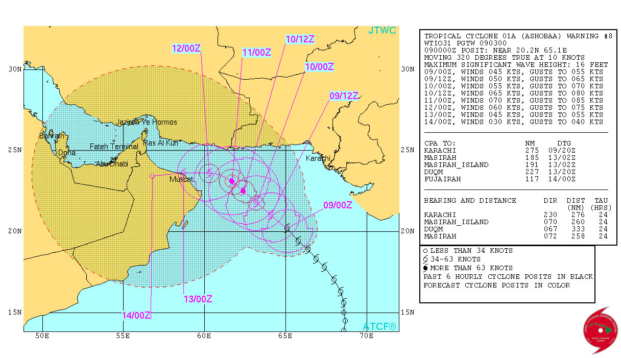
JTWC Location 20.2N & 65.1E. with 45 knots Winds & 989 mb. Central Pressure on 9th June 2015 @ 0000 UTC (05.00 am. IST)
JTWC Tropical Cyclone 01A.ASHOBAA Warning Number 8 Dated 9th June
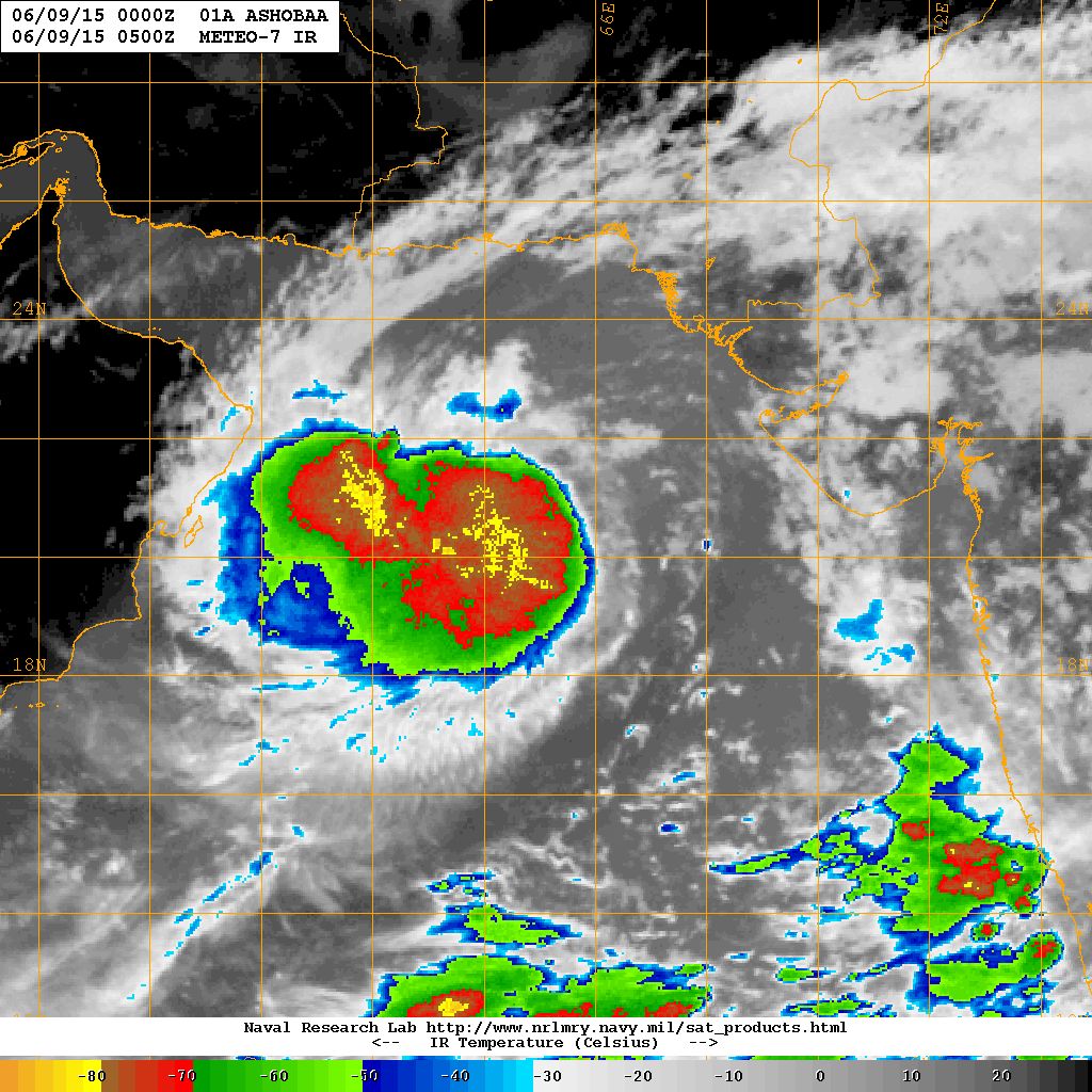
NRL IR Satellite Image on 9th June @ 0500 UTC (10.30 am. IST)
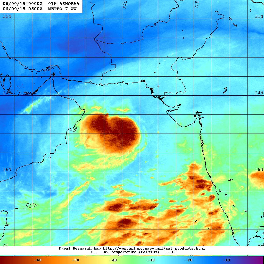
NRL Water Vapor Satellite Image on 9th June @ 0500 UTC (10.30 am. IST)
Caution:
Please refer/rely on IMD/RSMC Bulletins/Advisories for Storms & Weather related matter.
સાવચેતી:
વાવાઝોડા કે હવામાન અંગે ની માહિતી માટે ભારતીય હવામાન ખાતા/ગવર્મેન્ટ ના બુલેટીન/સુચના પર નિર્ભર રહેવું.