Current Weather Conditions on 9th June 2015 @ 8.30 pm. IST
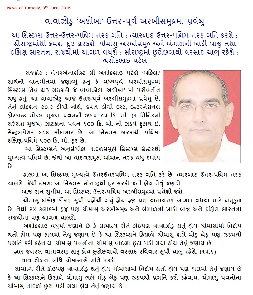
“ASHOBAA” નામ નું વાવાઝોડું આજે ઊત્તર પૂર્વ અરબી સમુદ્ર માં પ્રવેશ્યું અને આજ સાંજ પછી તે પશ્ચિમ અરબી સમુદ્ર માં પ્રવેશી ચુક્યું છે.
મતલબ કે આ સીસ્ટમ ક્રમશ સૌરાષ્ટ્ર ના દરિયા કિનારા થી દૂર જાય છે. પવન 90 કિમી (1 મિનીટ ની શરેરાશ મૂજબ ) અને સેન્ટ્રલ પ્રેસર 985 મિલીબાર છે.
આ સીસ્ટમ અને ચોમાસું વાદળો અલગ પડી ગયા છે માટે ચોમાસા ને 24 થી 48 કલાક માં આગળ ચાલવા માટે સાનૂકૂળ પરિસ્થિતિ છે.
સૌરાષ્ટ , ગુજરાત અને કચ્છ ને એક બે દિવસ છૂટો છવાયો વરસાદ નો લાભ આ સીસ્ટમ ના પૂછડિયા વાદળા થી મળશે. ત્યાર બાદ પ્રિ મોન્સૂન એક્ટીવીટી થી તારીખ 14 સુધી સૌરાષ્ટ્ર, ગુજરાત અને કચ્છ ને થોડો ઘણો ફાયદો થશે. સૌરાષ્ટ્ર , ગુજરાત અને કચ્છ માં બેઠું નથી.
સુચના: માટે “અમારા વિસ્તાર માં ક્યારે અને કેટલો વરસાદ પડશે?” તેવા સવાલો પૂછવા નહિ અને તે પ્રશીધ્ધ નહિ થાય.
Bulletin No.: 15 (ARB01/2015)
Time of issue: 1730 hours IST
Dated: 09.06.2015
FROM: INDIA METEOROLOGICAL DEPARTMENT (Fax No. 24699216/24623220)
Sub: Cyclonic Storm (ASHOBAA) over northwest Arabian Sea and adjoining area
Cyclonic Storm “ASHOBAA” has crossed over to North East Arabian Sea in the morning and subsequently crossed over to Northwest Arabian Sea. The dense clouding associated with this System are mainly located to the West of the System center compared to the East, hence it looks as if the System is more towards Oman as compared to Saurashtra coast. The System is moving away from Saurashtra coast as it has tracked Northwest and now will track West Northwest direction towards Oman.
The Monsoon clouding are now dis-associated from the Cyclonic Storm ‘ASHOBAA” and hence conditions are favorable for further advancement of Southwest Monsoon over parts of Central Arabian Sea , parts of Bay of Bengal and some more parts of South India & Konkan.
Saurashtra, Gujarat & Kutch: Scattered rainfall due to the effects of the Cyclonic activity for a day or two and then it will continue for few more days and the it will continue as pre-monsoon activity.
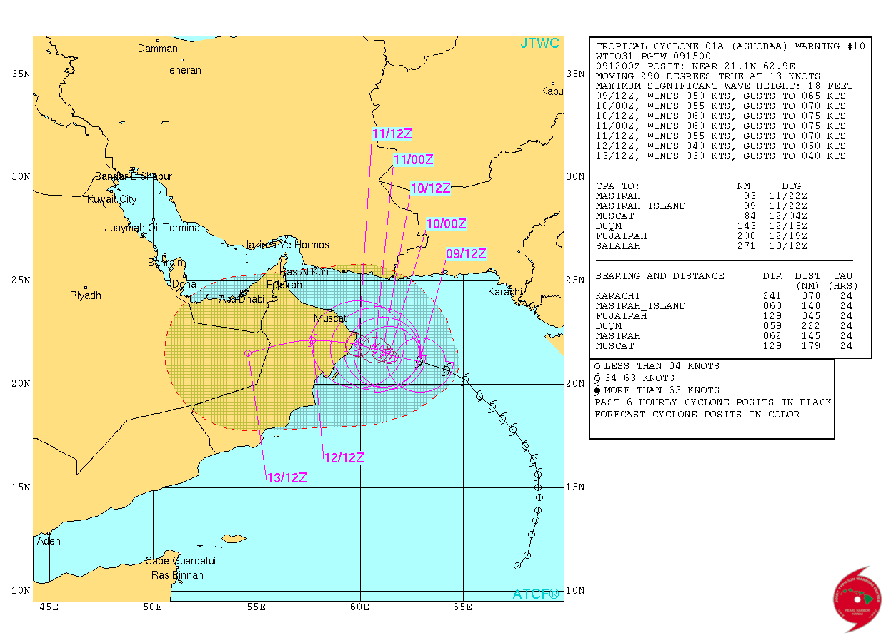
JTWC Location 21.1N & 62.9E. with 50 knots Winds & 985 mb. Central Pressure on 9th June 2015 @ 1200 UTC (05.30 pm. IST)
JTWC Tropical Cyclone 01A.ASHOBAA Warning Number 10 Dated 9th June
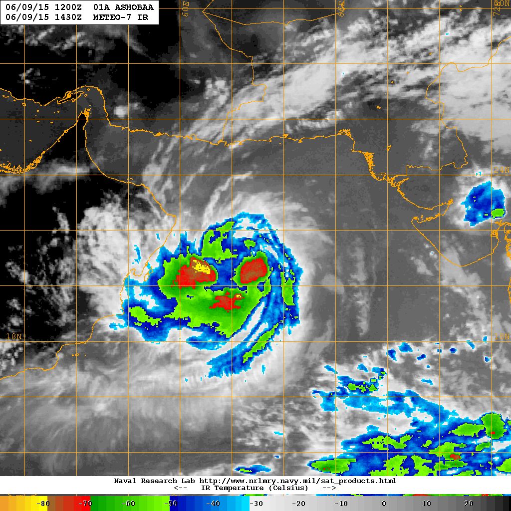
NRL IR Satellite Image on 9th June @ 1430 UTC (8.00 pm. IST)
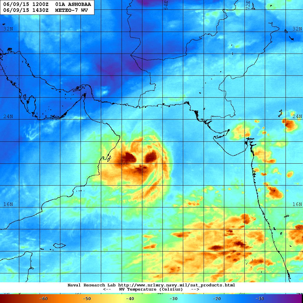
NRL Water Vapor Satellite Image on 9th June @ 1430 UTC (8.00 pm. IST)
Weather Forecast In Akila Daily Dated 9th June 2015
Caution:
Please refer/rely on IMD/RSMC Bulletins/Advisories for Storms & Weather related matter.
સાવચેતી:
વાવાઝોડા કે હવામાન અંગે ની માહિતી માટે ભારતીય હવામાન ખાતા/ગવર્મેન્ટ ના બુલેટીન/સુચના પર નિર્ભર રહેવું.