Current Weather Conditions on 2nd September 2014 @ 11.00 pm.
The rainfall activity has improved from 30th August on wards with light to medium to heavy rainfall being reported from most places in Gujarat, Saurashtra & Kutch.
The Well Marked Low Pressure lay over Northwest Madhya Pradesh and vicinity this morning. Under the influence of a Upper Air Circulation over South Rajasthan a Low Pressure area has formed this morning over Saurashtra, Kutch and nearby Northeast Arabian Sea. Associated Cyclonic Circulation extends up to Mid-Tropospheric level and tilting Southwestwards with height. Both these low have now merged into a broad Low Pressure area over Saurashtra, Kutch, South Rajasthan, Sindh and adjoining Northeast Arabian Sea.
IMD MSL Pressure Forecast Map Valid for 1200 UTC 2nd September 2014
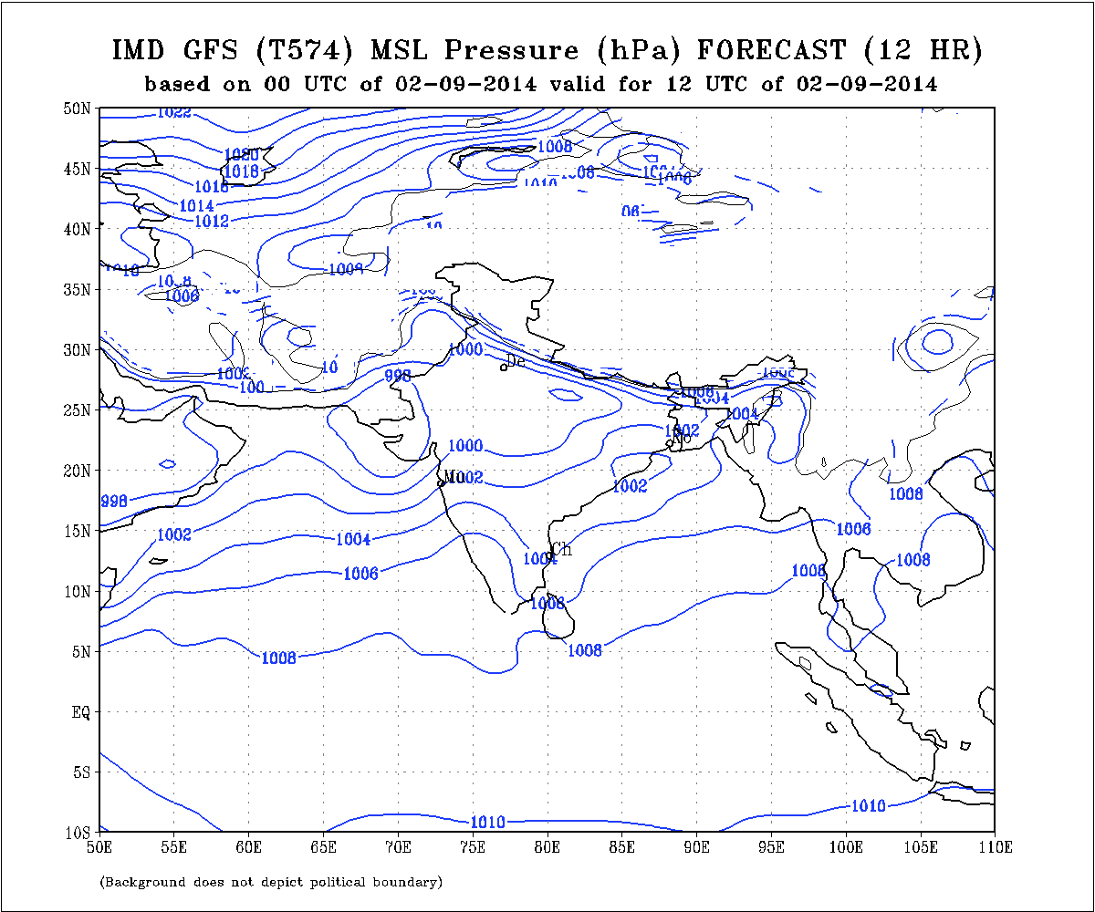
The axis of monsoon trough at mean sea level now passes through Center of Low Pressure area over Saurashtra & Kutch and adjoining Northeast Arabian Sea, Vadodara, West Madhya Pradesh and neighborhood, Pendra, Chandbali and thence Southeastwards to East Central Bay of Bengal. It extends upto 3.1 Kms above sea level passing across the same region.
The Off-shore trough at mean sea level is active from South Gujarat coast to Lakshadeep area.
The Western Disturbance as an Upper Air Cyclonic Circulation now extends between 3.1 & 4.5 Kms. above sea level over North Pakistan and adjoining Jammu & Kashmir, with a trough aloft. System would move East Northeastwards.
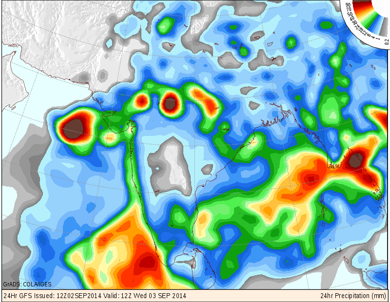
COLA/IGES GFS Precipitation Forecast Map Valid 12 UTC 3rd September 2014
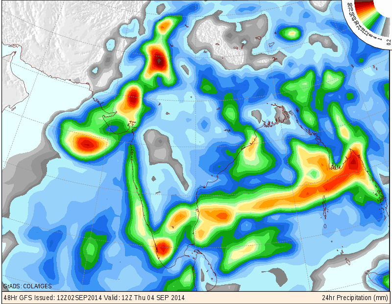
COLA/IGES GFS Precipitation Forecast Map Valid 1200 UTC 4th September 2014
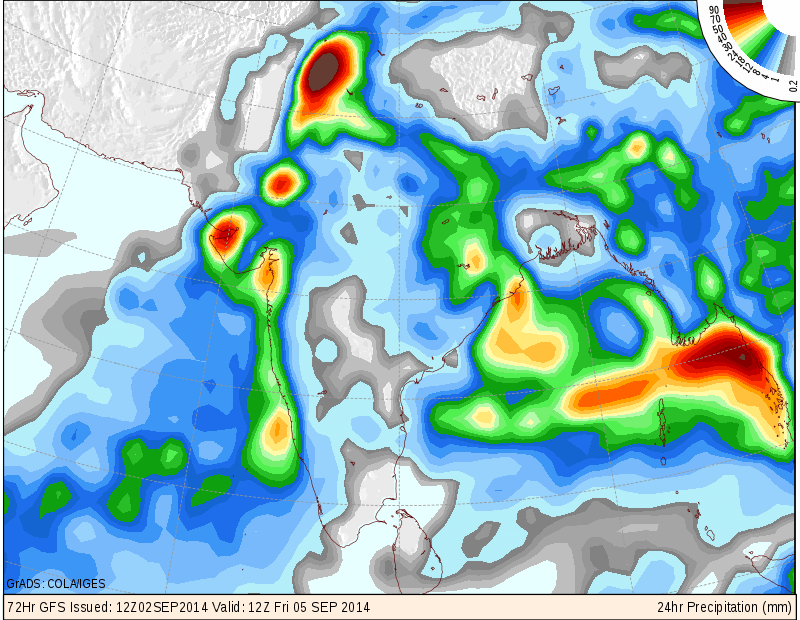
COLA/IGES GFS Precipitation Forecast Map Valid 1200 UTC 5th September 2014
Forecast: 3rd September 5th September 2014
Saurashtra, Gujarat & Kutch :
The Low Pressure over Western Saurashtra, Kutch and adjoining Northeast Arabian sea is expected to remain in vicinity of Kutch and then Western end of monsoon trough will align towards Jaisalmer by 5th September to become the normal Western end of Monsoon trough.
Medium heavy rainfall expected in few Districts of Saurashtra, Gujarat and many parts of Kutch. Rainfall areas could change daily depending upon the alignment of the Low Pressure and the wind direction thereto. Rest of the areas could get scattered showers/light rain on some days of the forecast period.
Fresh Low Pressure over Bay of Bengal will develop after 5th September, most probably around 6th/7th September.
NOTE: On Vacation so post will be put if time permits !
સૌરાષ્ટ્ર, ગુજરાત અને કચ્છ :
તારીખ ૩ સપ્ટેમ્બર થી ૫ સપ્ટેમ્બર ૨૦૧૪:
બંગાળની ખાડી વાળું લો પ્રેસર આજે સવારે ઊત્તર પશ્ચિમ એમ.પી. ઉપર હતું. દક્ષીણ રાજસ્થાન ઉપર એક UAC હતું અને તેની અસર રૂપે આજે સવારે સૌરાષ્ટ્ર, કચ્છ અને લાગુ ઊત્તર પૂર્વ અરબી સમુદ્ર ઉપર એક લો પ્રેસર થયું. આ બંને લો પ્રેસર આજે સાંજે ભળી ગયા છે, જે કચ્છ, સૌરાષ્ટ્ર, સિંધ અને લાગુ ઊત્તર પૂર્વ અરબી સમુદ્ર ઉપર છવાયેલ છે.
આ લો સૌરાષ્ટ્ર કચ્છ આસ પાસ ના વિસ્તાર માં એક બે દિવસ રહેશે અને ત્યાર બાદ તે જેસલમેર રાજથાન તરફ ૫ તારીખે પોંચશે.
વરસાદ લો પ્રેસર ના લોકેસન તેમજ પવનો ની દિશા ઉપર નિર્ભર રહેશે.
સૌરાષ્ટ્ર અને ગુજરાત ના અમૂક ભાગ માં મધ્યમ અને ભારે વરસાદ થશે બાકી ના સૌરાષ્ટ્ર અને ગુજરાત ના વિસ્તારો માં હળવો વરસાદ થશે અથવા ઝાપટા પડશે. કચ્છ ના ઘણા ભાગ માં મધ્યમ ભારે વરસાદ થશે.
બંગાળની ખાડી માં નવું લો પ્રેસર ૫ તારીખ પછી થશે અંદાજે ૬/૭ તારીખ આસપાસ .
નોંધ: રજા માં બહાર ગામ હોવા થી નવી અપડેટ માટે વેલા મોડું ગણવું તેમજ પોસ્ટ ના જવાબ પણ વેલા મોડા મળશે.
Scroll Up