Current Weather Conditions on 31st October 2014 @ 8.00 am.
For Latest Bulletin from REGIONAL SPECIALISED METEOROLOGICAL CENTRE-TROPICAL CYCLONES, NEW DELHI click here…
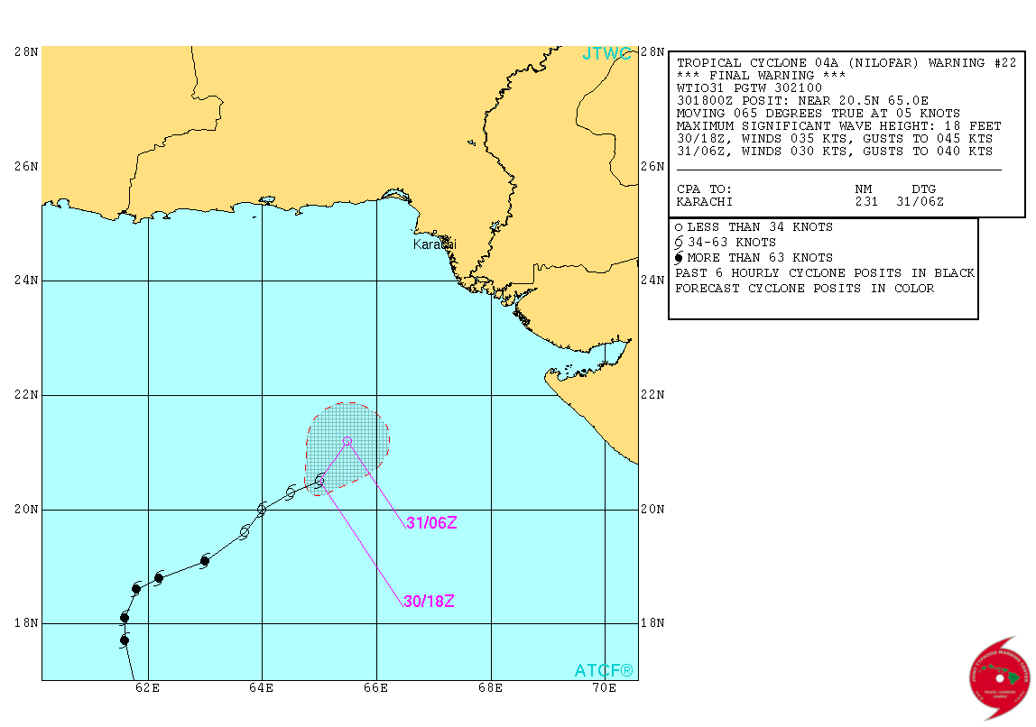
‘NILOFAR’ has weakened to just 30 knots (55 kms./hour on 1 minute average basis) and is currently over the Northeast Arabian Sea. The Clouding associated with this System is over Saurashtra, Kutch, North Gujarat & Northeast Arabian Sea. The System Center is located at Lat 20.6 N & Long. 65.1 E. @ 0000 UTC . and the dense convective clouds are located Northeast of the System Center.
Distance of System Center from Naliya: 485 Kms. @ 0000 UTC
Distance of System Center from Dwarka: 440 Kms. @ 0000 UTC
Location at 0000 UTC on 31st October 2014 is Lat. 20.6 N & Long. 65.1 E with 30 knots winds (55 kms./hour on 1 minute average speed basis) and 1000 mb. Central Pressure.
Tropical Cyclone 04A (Nilofar) Warning #22 Issued at 30/2100Z
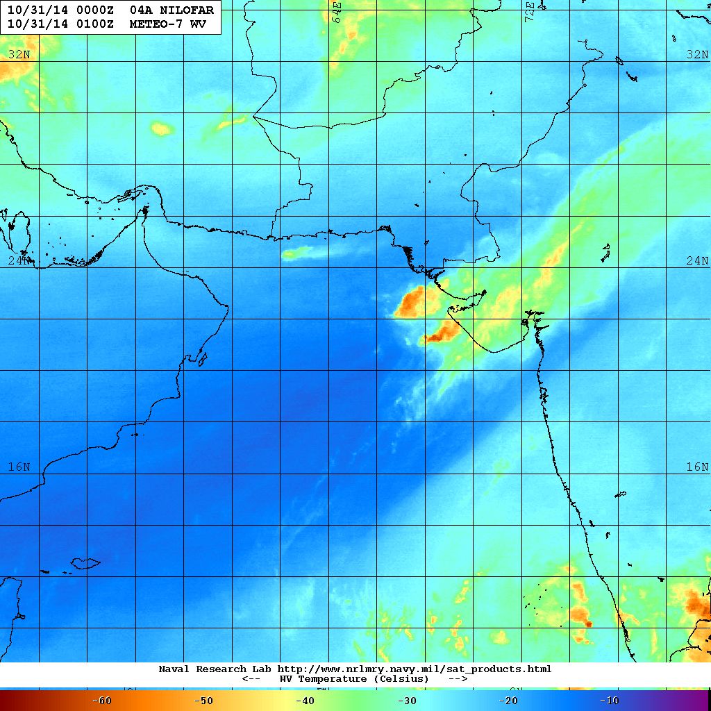
NRL IR Satellite Image of 04A.NILOFAR
Dated 31st October 2014 @ 0130 UTC

NRL Water Vapor Satellite Image of 04A.NILOFAR
Dated 31st October 2014 @ 0100 UTC
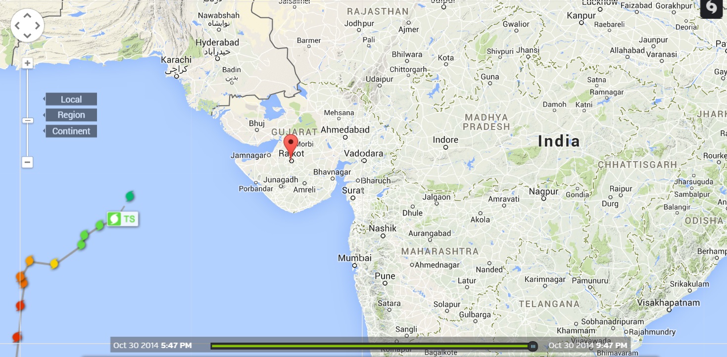
Wunderground Map Showing Cyclone ‘NILOFAR’ Track
Till 31st October @ 0000 UTC ( 05.30 am. IST )
Wunderground Map Showing Clouding & Cyclone ‘NILOFAR’ Track
Till 31st October @ 0000 UTC ( 05.30 am. IST )

Forecast: 31st October to 2nd November 2014
‘NILOFAR’ has lost Cyclone strength at 30 knots over Northeast Arabian Sea and is not expected to make landfall. The System is expected to dissipate over sea water in the vicinity of Saurashtra/Kutch/Sindh within 24 hours. Clouding associated with the System is spread over Saurashtra, Kutch & North Gujarat and adjoining Northeast Arabian Sea will remain till 1st November. Scattered showers, light rainfall is expected over parts of Saurashtra & Kutch with isolated medium rainfall over Kutch and Coastal areas of Saurashtra till 1st November. Since the System has weakened considerably, winds will be lower than expected earlier.
Caution: Please refer/rely on IMD/RSMC Bulletins/Advisories for Storms & Weather related matter.
આગાહી તારીખ ૩૧ ઓક્ટોબર થી ૨ નવેમ્બર ૨૦૧૪:
‘નીલોફર’ વાવાઝોડું નબળી પડી અને ડીપ્રેસન ની માત્રા સુધી પોન્ચ્યું છે. તારીખ ૩૧ ઓક્ટોબર ૨૦૧૪ ભારતીય સમય મૂજબ સવારે ૫.૩૦ કલાકે ૩૦ નોટ ના પવનો છે ( ૫૫ કિમી પ્રતિ કલાક ના ૧ મિનીટ ની એવરેજ મૂજબ ) .
આ સીસ્ટમ જમીન ઉપર નહિ આવે પરંતુ સૌરાષ્ટ્ર/કચ્છ/સિંધ નજીક ના દરિયા માં જ ૨૪ કલાક માં ખતમ થઇ જશે. આ સીસ્ટમ ના અનૂસંગિક વાદળ સમૂહો સૌરાષ્ટ્ર કચ્છ, ઊત્તર ગુજરાત અને લાગુ ઊત્તર પૂર્વ અરબી સમુદ્ર ઉપર ૧ નવેમ્બર સુધી ફેલાયેલ રહેશે. સૌરાષ્ટ્ર કચ્છ અને ઊત્તર ગુજરાત ના અમૂક વિસ્તારો માં છાંટા છૂટી થી માંડી હળવો વરસાદ પડશે. કોઈ કોઈ જગ્યાએ ખાસ કચ્છ અને સૌરાષ્ટ્ર ની પશ્ચિમ કોસ્ટલ પટ્ટી માં મધ્યમ વરસાદ ની શક્યતા છે. સીસ્ટમ નબળી પડી હોઈ પવન ની તીવ્રતા ઓછી રહેશે.
વાવાઝોડાના પવન બાબત ની સમજ :
ઊત્તર ગોળાર્ધ્ધ માં વાવાઝોડું હોઈ તેને અનૂસંગિક પવનો વાવાઝોડાના સેન્ટર થી એન્ટીકલોક(ઘડિયાળ ના કાંટા થી વિરૂદ્ધ )દિશામાં ફૂંકતા હોઈ છે.
વાવાઝોડાના પવનો ની ઝડપ ની જયારે વાત થતી હોઈ તે તેટલી સ્પીડે ફૂંકતા હોઈ છે. વાવાઝોડું પોતે તો બહુ ધીમી સ્પીડે આગળ ચાલતું હોઈ છે. સામાન્ય રીતે ૫ થી ૧૫ કિમી પ્રતિ કલાકે આગળ ચાલતું હોઈ છે. હવામાન ખાતા મૂજબ પવન ની ઝડપ નોટ તેમજ કિ.મી. પ્રતિ કલાક પ્રમાણે હોઈ છે જે ૩ મિનીટ ની શરેરાશ પવન ની ઝડપ મૂજબ હોઈ છે. ઇન્ટરનેશનલ હવામાન એજન્સીઓ મૂજબ પવન ની ઝડપ નોટ તેમજ માઇલ પ્રતિ કલાક પ્રમાણે હોઈ છે જે ૧ મિનીટ ની શરેરાશ પવન ની ઝડપ મૂજબ હોઈ છે. ૧ નોટ =૧.૮૫૨ કી.મી. ૧ નોટ =૧.૧૫ માઇલ
એટલે ઇન્ટરનેશનલ હવામાન એજન્સીઓ તરફ થી પવન ની ઝડપ ભારતીય હવામાન ખાતા કરતા સામાન્ય રીતે ૧૦ % થી ૧૫ %વધુ હોઈ છે.
આ આગાહી http://www.gujaratweather.com – અશોક પટેલ ની છે.
નોંધ: વાવાઝોડા અને આવી સીસ્ટમ માટે હવામાન ખાતા ની માહિતી ઉપર મદાર રાખવો.
Weather Forecast In Akila Daily Dated 31st October 2014