Current Weather Conditions on 17th September 2014 @ 06.30 am.
A Low Pressure area formed over Northwest Bay of Bengal and adjoining Coastal areas of Odisha and West central Bay of Bengal yesterday morning. Last evening the Low Pressure area was over West Central Bay of Bengal and adjoining Coastal Andhra Pradesh. Associated Upper Air Cyclonic Circulation extends up to 7.6 Kms. above mean sea level tilting South Westwards with height.
The Western end of monsoon trough runs close to the foothills of Himalayas and Eastern end passess through Lucknow, Pendra, Center of Low Pressure area and thence South Eastwards to Andaman Sea. It extends up to 1.5 Kms. above mean sea level.
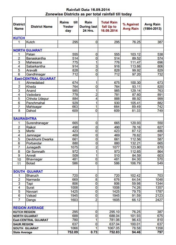
Zone Wise District Rainfall Data For Whole Gujarat till 16th September 2014
IMD criteria for Withdrawal of SW Monsoon
a) Withdrawal from extreme north-western parts of the country is not attempted before 1stSeptember.
b) After 1st September:
The following major synoptic features are considered for the first withdrawal from the western parts of NW India.
i) Cessation of rainfall activity over the area for continuous 5 days.
ii) Establishment of anticyclone in the lower troposphere (850 hPa and below)
iii) Considerable reduction in moisture content as inferred from satellite water vapor imageries and tephigrams.
Further Withdrawal from the Country
i) Further withdrawal from the country is declared, keeping the spatial continuity, reduction in moisture as seen in the water vapor imageries and prevalence of dry weather for 5 days.
ii) SW monsoon is from the southern peninsula and hence from the entire country only after 1st October, when the circulation pattern indicates a change over from the South Westerly wind regime.
Map Showing The Normal Date For Withdrawal Of Southwest Monsoon From India

Forecast: 17th September to 22nd September 2014
Saurashtra, Gujarat & Kutch :
Current Low Pressure of Bay of Bengal will not affect Saurashtra & Gujarat & Kutch.
Mainly dry weather will prevail over large parts with some scattered showers or isolated light rain on a few days at a few places of the forecast period. Some parts of Gujarat could get light rain/showers on more days than Saurashtra or Kutch.
NOTE: On Vacation so post will be put if time permits !
સૌરાષ્ટ્ર, ગુજરાત અને કચ્છ :
તારીખ સપ્ટેમ્બર ૧૭ થી ૨૨ સપ્ટેમ્બર ૨૦૧૪:
બંગાળની ખાડી નું હાલ નું લો પ્રેસર સૌરાષ્ટ્ર ગુજરાત અને કચ્છ ને અસરકર્તા નહિ થાય.
તારીખ ૧૭ થી ૨૨ સપ્ટેમ્બર દરમ્યાન મુખ્યત્વે વરસાદ નો વિરામ રહેશે. ટૂક માં હાલ કોઈ મોટો વરસાદ નથી. સૌરાષ્ટ્ર, ગુજરાત, કચ્છ અને ગુજરાત માં કોઈ કોઈ દિવસે છુટા છવાયા ઝાપટા અથવા હળવો વરસાદ સીમિત વિસ્તાર માં થઇ શકે.
નોંધ: રજા માં બહાર ગામ હોવા થી નવી અપડેટ માટે વેલા મોડું ગણવું તેમજ પોસ્ટ ના જવાબ પણ વેલા મોડા મળશે.
Scroll Up