Multiple Rounds of Rainfall Likely Over Saurashtra, Kutch & Gujarat: 21st–28th June 2025
સૌરાષ્ટ્ર, કચ્છ અને ગુજરાતમાં 21થી 28 જૂન 2025 દરમિયાન એકથી વધુ વખત વરસાદ ના રાઉન્ડ ની શક્યતા
Current Weather Conditions – 21st June 2025
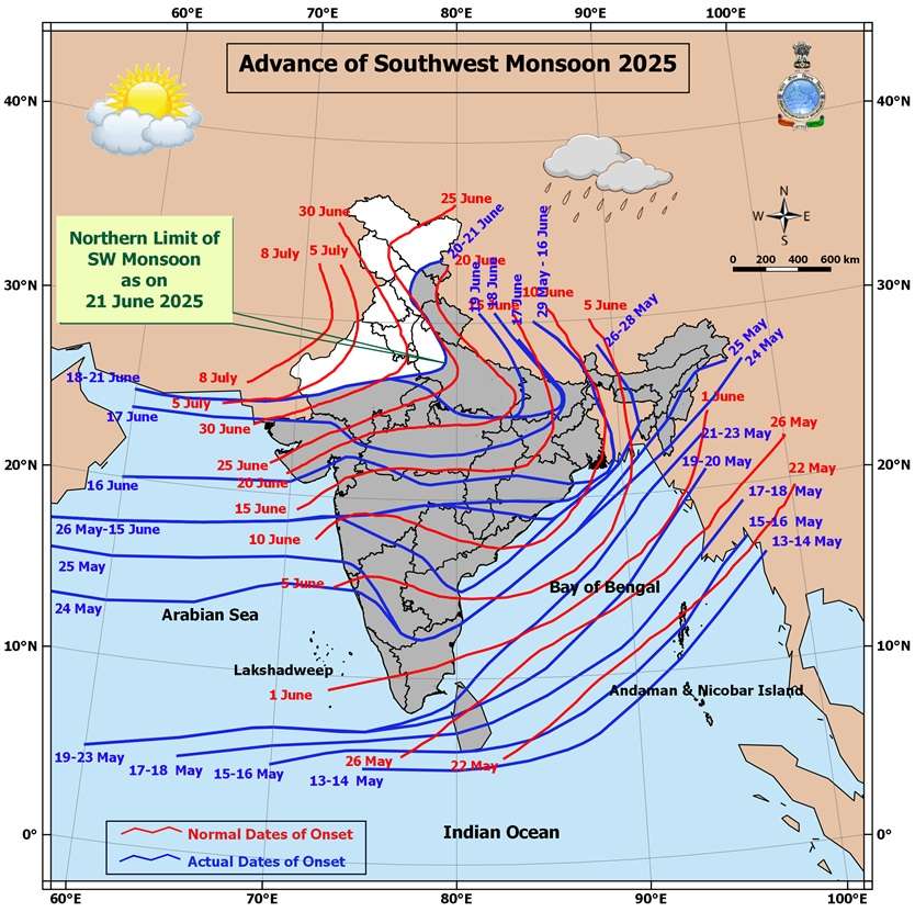
Northern Limit of Monsoon (NLM):
The NLM continues to pass through:
25.0°N/60.0°E, 25.0°N/65.0°E, 25.5°N/70.0°E, Jaipur, Agra, Rampur, Dehradun, Shimla, Manali, and 33.5°N/79.0°E.
Monsoon Progress Outlook:
-
Conditions are favorable for further advance of the Southwest Monsoon over:
-
Remaining parts of North Arabian Sea
-
Additional parts of Rajasthan
-
Remaining parts of West Uttar Pradesh, Uttarakhand, Himachal Pradesh
-
Some parts of Jammu & Kashmir, Gilgit-Baltistan, Muzaffarabad, and Ladakh
in the next 2 days
-
-
Further, conditions are becoming favorable for the monsoon to advance into:
-
Remaining parts of Jammu & Kashmir and Ladakh
-
Some parts of Punjab, Haryana, Chandigarh & Delhi
in the subsequent 2 days -
-
Synoptic Features
-
A Low Pressure Area lies over southwest Bihar & neighborhood, with an associated upper air cyclonic circulation tilting southward with height in the middle tropospheric levels.
It is expected to move slowly northwestward and weaken gradually over the next 12 hours. -
An upper air cyclonic circulation is present over northeast Rajasthan & neighborhood in the lower tropospheric levels.
-
A trough runs from northeast Bangladesh to south Gujarat, passing through:
-
The cyclonic circulation associated with the low pressure area over southwest Bihar
-
Central parts of Madhya Pradesh, in the lower tropospheric levels
-
Expected Weather Parameters
Forecast Period: 21st – 28th June 2025
MSLP (Mean Sea Level Pressure):
-
The off-shore trough along the South Gujarat to Kerala coast is expected to remain active on some days, enhancing monsoon activity.
925 hPa Level:
-
A monsoon low is expected to persist north of normal, remaining positioned over North India throughout the forecast period.
850 hPa Level:
-
An East-West shear zone or cyclonic circulation is likely to develop from East India towards Gujarat, influencing rainfall distribution and intensity.
700 hPa Level (Key Synoptic Layer):
-
22nd June: A broad cyclonic circulation is expected to extend from Bihar to Gujarat.
- Another upper air cyclonic circulation is likely to form over Gangetic West Bengal & neighborhood around 25th June.
-
26th June: The UAC over West Bengal is likely to track westward toward Gujarat. Broad Circulation expected.
-
By 26th/27th June: The broad circulation is expected to shrink and consolidate, becoming more concentrated near Madhya Pradesh and Gujarat.
Rainfall Forecast for Saurashtra, Kutch & Gujarat
Period: 21st to 28th June 2025
-
On some days, light to moderate rainfall (10 to 35 mm) is expected over scattered areas.
-
On other days, fairly widespread rainfall (10 to 35 mm) is likely.
-
Cumulative rainfall during the forecast period may range from 50 mm to 100 mm over most areas (wide spread).
-
Isolated pockets may receive heavy rainfall (35 to 100 mm) on a few days.
-
At select locations, total rainfall could exceed 200 mm during the period, especially where such heavier spells occur.
સૌરાષ્ટ્ર, કચ્છ અને ગુજરાતમાં 21થી 28 જૂન 2025 દરમિયાન એકથી વધુ વખત વરસાદ ના રાઉન્ડ ની શક્યતા
હાલની હવામાન પરિસ્થિતિ – 21st June 2025
મોન્સૂનની ઉત્તર સીમા (Northern Limit of Monsoon – NLM):
NLM નીચેના સ્થળો પરથી પસાર થાય છે:
25.0°N/60.0°E, 25.0°N/65.0°E, 25.5°N/70.0°E, Jaipur, Agra, Rampur, Dehradun, Shimla, Manali, અને 33.5°N/79.0°E.
મોન્સૂન પ્રગતિ પૂર્વાનુમાન:
હાલની પરિસ્થિતિઓ દર્શાવે છે કે આગામી 2 દિવસમાં મોસમ પૂર્વ દક્ષિણ પશ્ચિમ મોન્સૂન આગળ વધવા માટે અનુકૂળ છે:
-
North Arabian Seaના બાકીના ભાગોમાં
-
Rajasthanના વધુ કેટલાક ભાગોમાં
-
West Uttar Pradesh, Uttarakhand, અને Himachal Pradeshના બાકીના ભાગોમાં
-
Jammu & Kashmir, Gilgit-Baltistan, Muzaffarabad, અને Ladakhના કેટલાક ભાગોમાં
પછીના 2 દિવસોમાં, દક્ષિણ પશ્ચિમ મોન્સૂન માટે નીચેના વિસ્તારોમાં પણ આગળ વધવા માટે પરિસ્થિતિ અનુકૂળ બની રહી છે:
-
Jammu & Kashmir અને Ladakhના બાકીના ભાગોમાં
-
Punjab, Haryana, Chandigarh & Delhiના કેટલાક ભાગોમાં
હાલ ના પરિબળો (Synoptic Features):
-
એક Low Pressure Area હાલ southwest Bihar & neighborhood પર સ્થિત છે, જેનાથી જોડાયેલું upper air cyclonic circulation મધ્યમ ટ્રોપોસ્ફેરિક સ્તરે ઊંચાઈ સાથે દક્ષિણ તરફ ઝૂકી રહ્યું છે.
આગામી 12 કલાકમાં તે ધીમે ધીમે ઉત્તરપશ્ચિમ તરફ ખસીને નબળું પડી શકે છે. -
એક upper air cyclonic circulation northeast Rajasthan & neighborhood પર lower tropospheric level પર કાર્યરત છે.
-
એક trough northeast Bangladeshથી લઈને south Gujarat સુધી ફેલાયેલો છે, જે પસાર થાય છે:
-
southwest Bihar પર આવેલા low pressure ના સંબંધિત cyclonic circulation
-
Madhya Pradeshના મધ્યભાગમાંથી
-
અપેક્ષિત હવામાન પરિબળો
અવધિ: 21st – 28th June 2025
MSLP (Mean Sea Level Pressure):
South Gujaratથી Kerala coast સુધીનો off-shore trough કેટલીક વાર સક્રિય રહેશે અને મોન્સૂન ગતિવિધિને સપોર્ટ આપશે.
925 hPa Level:
મોન્સૂન low સામાન્ય કરતા ઉત્તરે સ્થિર રહેશે અને Poorva Bharatથી North India સુધી વિસ્તૃત રહેશે.
850 hPa Level:
East India થી Gujarat તરફ East–West shear zone અથવા cyclonic circulation વિકસવાની શક્યતા છે, જે વરસાદની વિતરણ પધ્ધતિને અસર કરશે.
700 hPa Level (મુખ્ય Synoptic સ્તર):
-
22nd June: Bihar થી Gujarat સુધી વિસ્થાપિત થયેલું વિશાળ cyclonic circulation જોવા મળવાની શક્યતા.
- 25th June આસપાસ Gangetic West Bengal & neighborhood પર એક નવી upper air cyclonic circulation વિકસવાની શક્યતા છે.
-
26th June: Bihar/West Bengal ઉપરનું UAC ધીમે ધીમે Gujarat તરફ ખસતું જશે. બહોળું સર્ક્યુલેશન થશે.
-
27th June સુધીમાં: આ વિશાળ સર્ક્યુલેશન સંકોચાઈને, Madhya Pradesh અને Gujarat નજીક વધુ કેન્દ્રીત થઈ શકે છે.
Saurashtra, Kutch & Gujarat માટે વરસાદનું પૂર્વાનુમાન
અવધિ: 21st to 28th June 2025
-
કેટલાક દિવસોમાં છૂટો છવાયો હળવો થી મધ્યમ વરસાદ (10 to 35 mm) થઈ શકે છે.
-
અન્ય દિવસોમાં ઠીક ઠીક વ્યાપક વિસ્તારોમાં હળવો થી મધ્યમ વરસાદ (10 to 35 mm) થવાની શક્યતા છે.
-
સમગ્ર વિસ્તાર માટે કુલ વરસાદ 50 mm થી 100 mm ની વચ્ચે રહી શકે છે.
-
અલગ અલગ સીમિત વિસ્તારોમાં કેટલાક દિવસો દરમિયાન ભારે વરસાદ (35 to 100 mm) પડી શકે છે.
-
ભારે વરસાદ વાળા સેન્ટરો માં (ખાસ કરીને જ્યાં ભારે વરસાદ વારંવાર થાય છે), ત્યાં કુલ વરસાદ 200 mm કરતાં વધુ થઈ શકે છે.
-
⚠️ Advisory
Caution: Please refer/rely on IMD/RSMC Bulletins/Advisories for Storms & Weather related matter.
સાવચેતી: સ્ટોર્મ કે હવામાન અંગે ની માહિતી માટે ભારતીય હવામાન ખાતા/ગવર્મેન્ટ ના બુલેટીન/સુચના પર નિર્ભર રહેવું.
Read Comment Policy – કમેન્ટ માટે માર્ગદર્શન વાંચો
How To Upload Profile Picture For WordPress – વર્ડપ્રેસ માં પ્રોફાઈલ પિક્ચર કેમ રાખવું
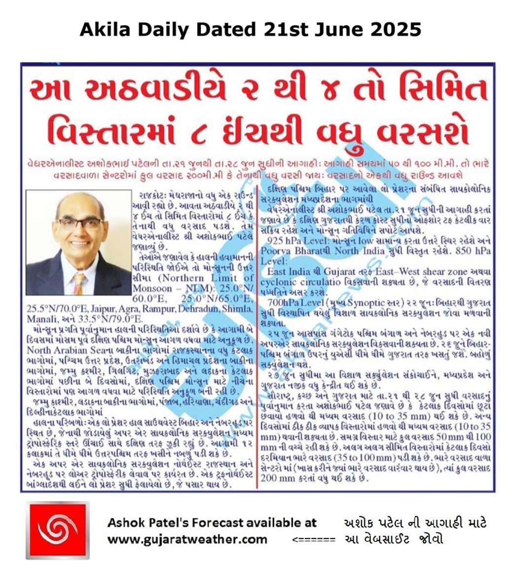
Forecast In Akila Daily Dated 21st June 2025
Forecast In Sanj Samachar Daily Dated 21st June 2025
તારીખ 29 જુન 2025 આજની પરિસ્થિતિ ભારતીય હવામાન વિભાગ અનુસાર મીડ ડે બુલેટિન ➢ નૈઋત્ય નું ચોમાસુ આજે 29 જૂન 2025 ના રોજ રાજસ્થાન, પશ્ચિમ ઉત્તર પ્રદેશ અને હરિયાણાના બાકીના ભાગો અને સમગ્ર દિલ્હીમાં આગળ વધ્યું છે. આમ, તે 29 જૂન, 2025 ના રોજ સમગ્ર દેશને આવરી લે છે, જે સામાન્ય તારીખ 08 જુલાઈ (સમગ્ર ભારતને આવરી લેવાની સામાન્ય તારીખથી 9 દિવસ પહેલા) છે. ➢ લો પ્રેશર આજે 29 જૂન 2025 ના રોજ ભારતીય સમય મુજબ સવારે 08:30 વાગ્યે ઉત્તર પશ્ચિમ બંગાળની ખાડી અને તેની આસપાસના પશ્ચિમ બંગાળ અને બાંગ્લાદેશ દરિયાકાંઠા પર છે. તેનુ આનુષાંગિક UAC સરેરાશ સમુદ્ર સપાટીથી 7.6 કિમી… Read more »
Sir tamari update ni Ghana raah jota hase pan tame badhu nichodine aagahi aapo cho perfect ane te pan 7 divas nu j hoy atle sir tame bijani jem bakajiki nathi bolavta je hoy te sachot hoy che pranam guruji ne
Sir,aaje bahu j saro varsad thyo.
કોઈ પણ લો પ્રેશર વિખેરવાના ક્યાં પરિબળો જવાબદાર હોય છે???
Surface ghumari ghati jaay etle ne aaju baaju na pressure najik pressure aavi jaay etle nabadu padi jaay.
Kutch upar low pressure thayo them south Rajasthan adjoining north Gujarat par low pressure hova chhata pan varsad na aavyo. Shu khutyu hase?
લો પ્રેશર હોય તો જ વરસાદ થાય એવુ ન હોય. ઘણી વાર બીજા પરિબળ માં પણ ધરવી દયે એટલો વરસાદ પડતો હોય છે.
Navi jaat ni update thayel chhe aaje atyare !
Jsk mitro, Lesson to learn…….Sir aa forcast nu Measurement and evaluation joy tamara anubhav ne salam che. possible hoy to ek clip/Ans dwara mahiti aapso……..karane aa samay gada ni forcast ma ghana Clean Bold thaya che.Baki tamara vakyo mujab j j j amare varsad no labh madiyo che, Aabhar.
સર વિડીના ફોરકાસ્ટ મોડલ જોતા એવુ લાગે છે કે અવતી 15 જુલાઇ સુધી બંગલ ની ખાદી માથી સિસ્તમ બનવાની ચાલી જ રહેશે.
Saru.
Haha
અમે તમારી સાથે સહમત .
Rainfall data update krjo sir
Karya
સર હવે નવી અપડેટ આપો ને
Pratik પાનસુરીયા સમા ચાર આપવા બદલ ખૂબ આભાર
Savarthi dholka
Ma madhyam varsad vache zordar zhapta chalu che
Jyare yellow alert orange and red alert apyu hatu tyara kaij na thayu have varsad thay aj che kal thi constant kyarek zarmar madhyam anne vacche vacche bhare varsad thay che.
Kudrat ne predict karwu impossible che.
Sir aaje bhajiya banavvana chho ne???
Besan ?
Sir Besan..2-3 tarikhe avase ke…?
સર આ રાઉન્ડ મા અમે રહી ગયાં 10mm પણ ના આવ્યો .
રેડા જ આવ્યા ધીમા ફુવારા જેવા માટી ભિની થાય એવા.
Wunderground મા રોજ વરસાદ બતાવે છે બતાવે એટલો એ નથી આવતો એનું શું કારણ હોય શકે?
Rainfall Data check karay !
Sir Aaje vaheli savar naa 4.30 am thi 6 am sudhi hadvo thi madhyam varsad (21thi 28 sudhi 175+30 mm =205 mm)
Sar aravudma amre 115mm tyo ૨૬,૨૭,૨૮
ગોંડલ તાલુકાના મોવિયા ગામ ત્રણ ચાર દિવસમાં વરસાદની શક્યતા છે નહિતર મારે કાલે પાણી ચાલુ કરવું છે મગફળીમાં લાંઘો મારે છે અમારે સાવ વરસાદ નથી જો બે ત્રણ દિવસમાં આવે એમ હોય તો જણાવજો
Ahi wunderground majoiy ne andaj karay.
Sir, Hal to khas varap made aevu lagtu nathi
& Avnara divaso ma tarikh 1,2,3,4 ma fari saurashtra,Kutch ,Gujarat ma 50% vistar ne Varsad no chuto chavayo labh madi shake. 700 hpa upar uac jota….abhiyash mujab ek andaj apu chu
Varsad hamna roj chaluj rese ocha vadhta pramaan ma.
બપોર બાદ રેડા ચાલુ છે સર કાલ થી રેડા ઝાપટા ચાલુ રેશે
મિત્રો તથા સરજી અમારે કાલે 2 ઇંચ જેવો વરસાદ પડિયો હતો અને આજે પણ 2 ઇંચ જેવો વરસાદ થય ગયો.સરજી હવે વરાપ આવશે કે નાં હજુ ચાલુ રહેશે વરસાદ. જણાવો જણાવો કઈક
Moje dariya na japta gai kale ane aaje 🙂
Aaje bapor thi gajvij sathe japta/varsad pde che 🙂
વરાપની અપડેટ ક્યારે આવશે??
હજુ ચોમાસુ સરખુ ચાલુ થયુ ત્યાં?
upleta taluka ma 52 gam che, emathi 54 ma haji pani nathi padiya nikahe !!! ha ha ha.
Aasha rakhi betha chi aagahi samay darmiyan ek var to choga dub pani kadhe!!!!
ઘણાને હજુ વરસાદની રાહ છે, તમારે વરસે છે તો વરસવા દયો.
વરસાદનો એક મોટો વિરામ આવે એવાં મને અણસાર દેખાય છે,
પાછતરો દિવાળી સુધી વરસાદનાં યોગ છે.
Sar mayur bhai kya aathar upar divadi sunthinu ketahase???
te vaat temne khyal hoy. Maney khyal nathi.
Tamare avigayo atale? Ghana badha ne baki se haju nirant rakho
Bhai haji amare gondal ma sav nahivat varsad chhe haji ak pan nano khado barano nathi khetar bara pani nathi nikdya
વરસાદની જરૂરછે અમારીબાજુ
Plz update today’s rainfall figures
Savare hadvo madhyam pachi
15-20 minutes thi saro varsad chalu che
સર હવે આવતા દિવસોમા આમારે વરસાદી વાતાવરણ રેસે કે વરાપ જેવુ ??
તારીખ 28 જુન 2025 આજની પરિસ્થિતિ ભારતીય હવામાન વિભાગ અનુસાર મીડ ડે બુલેટિન ➢ નૈઋત્ય ના ચોમાસાની રેખા 27.0°N/68.5°E, 27.0°N/70.0°E, જેસલમેર, બિકાનેર, ઝુનઝુનુ, ભરતપુર, રામપુર, સોનીપત, અનુપ નગર અને 29.0°N/70.0°E માંથી પસાર થાય છે. ➢ નૈઋત્ય નું ચોમાસું આગામી 2 દિવસ દરમિયાન દેશના બાકીના ભાગોમાં આગળ વધવા માટે પરિસ્થિતિઓ અનુકૂળ બની રહી છે. ➢ સૌરાષ્ટ્ર અને કચ્છ અને લાગુ ઉત્તરપૂર્વ અરબી સમુદ્ર પર રહેલા UAC ના પ્રભાવ હેઠળ, આજે, 28 જૂન, 2025 ના રોજ ભારતીય સમય મુજબ સવારે 08:30 કલાકે કચ્છ અને તેના આસપાસના વિસ્તારો પર લો પ્રેશર રચાયુ છે અને તેનુ આનુષાંગિક UAC સરેરાશ સમુદ્ર સપાટીથી 7.6 કિમી સુધી… Read more »
Still eagerly waiting for good rains.
આજે બપોરે બે વાગ્યા થી મીઠો મેઘ શરૂ થયો ના પવન ના ગાજવીજ એયને ધીમીધારે મંડાણો મારો વાલો
Sir aa round ma proper jamnagar& ajubaju na vistar ma kyay pn varsad nathi, to have agahi samay ma chance ketla??
આજ ની રાત છે હજુ આગાહી સમય પૂરો થવા ને
આશા રાખી શકાય કે રાતે વારો આવી જાય .
કાલે અમારે ૩૦ મિનિટ મા અઢી ઇંચ વરસાદ પડ્યો પણ સેટેલાઇટ ઇમેજ મા કઈ ખાસ બતાડતું ન હતું.. તો શું એનું કારણ બહુ જ લો લેવલ મા વાદળો હશે… ??? આનું કારણ લો પ્રેશર ફોર્મેશન હોઈ શકે???
Varsad kyarek aachha vadad hoy full aavata hoy
Sir varap thahe ke nay
Porbandar City Ma modi raat no bhare Pavan ane Gajvij sathe savar thi Hadvo thi Medium Varsad continue haal chalu j che.