Multiple Rounds of Rainfall Likely Over Saurashtra, Kutch & Gujarat: 16th–23rd August 2025
સૌરાષ્ટ્ર, કચ્છ અને ગુજરાતમાં 16થી 23 ઓગસ્ટ 2025 દરમિયાન એકથી વધુ વખત વરસાદ ના રાઉન્ડ ની શક્યતા
Current Weather Conditions – 14th August 2025
-
- Synoptic Features:
Meteorological Analysis (Based on 0530 hrs IST, 14th August 2025)
- Low Pressure Area:
Yesterday’s low pressure over West Central & adjoining Northwest Bay of Bengal (off North Andhra Pradesh and South Odisha coasts) persisted at 0530 hours IST today.- The associated upper air cyclonic circulation extends up to 7.6 km above mean sea level, tilting southwards with height.
- It is likely to move west-northwestwards across North Coastal Andhra Pradesh and South Odisha over the next 48 hours.
- Monsoon Trough:
At mean sea level, the trough passes through Sri Ganganagar → Churu → Guna → Jabalpur → Raipur → south-southeastwards to the center of the low-pressure area over West Central & adjoining Northwest Bay of Bengal. - Upper Air Cyclonic Circulations:
- Over Himachal Pradesh & adjoining Jammu: persists between 1.5 – 3.1 km above mean sea level.
- Over Kutch & neighborhood: present over Northeast Arabian Sea & adjoining Kutch at 3.1 km above mean sea level.
- Over Northeast Assam: persists up to 3.1 km above mean sea level.
- Over Northwest Uttar Pradesh & adjoining Haryana: extends over south Haryana & adjoining north Rajasthan up to 0.9 km above mean sea level.
- Troughs / Other Features:
- An east-west trough from central Bay of Bengal to Northeast Arabian Sea (adjoining Kutch), across the upper air cyclonic circulation of the West Central & adjoining Northwest Bay of Bengal low, Telangana, North Maharashtra, and South Gujarat, persists between 1.5 – 5.8 km above mean sea level, tilting southwards with height.
- Low Pressure Area:
- Synoptic Features:
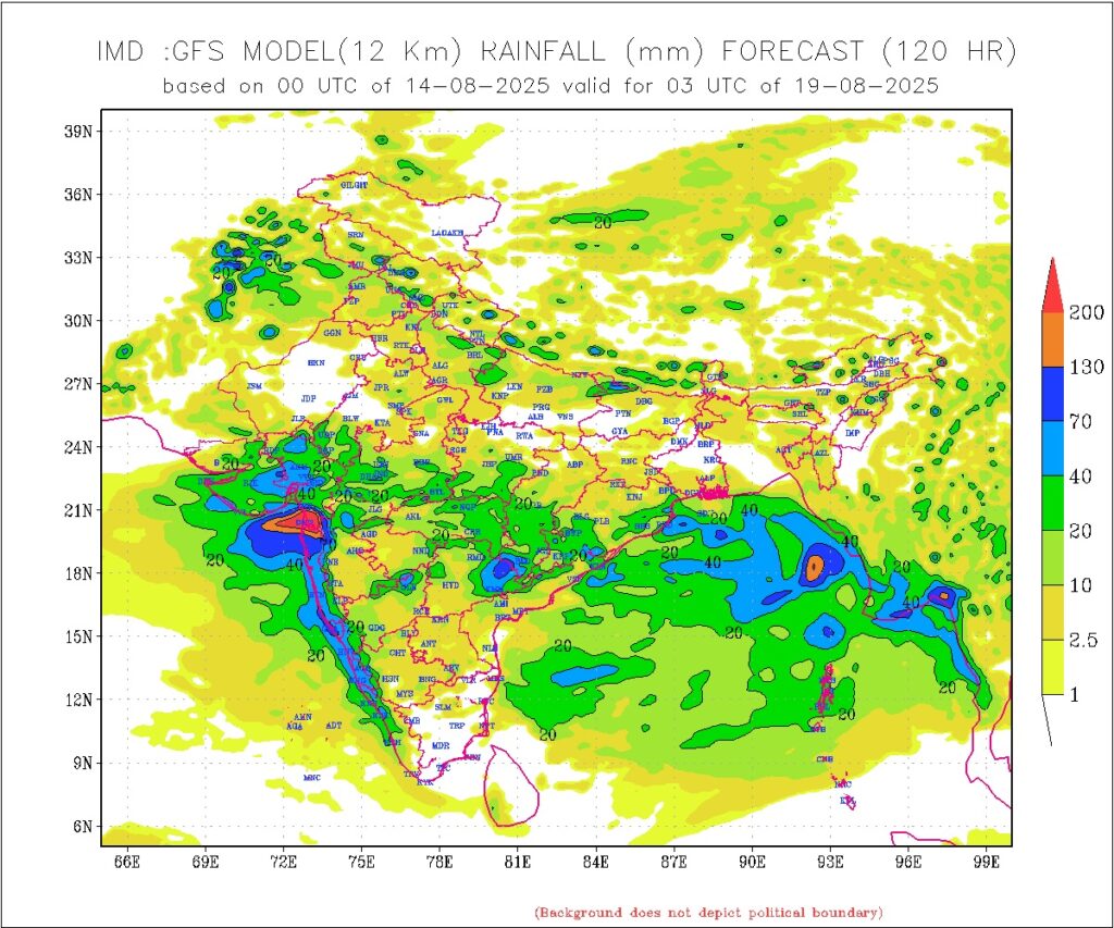
Rainfall Forecast for Saurashtra, Kutch & Gujarat
Period: 16th to 23 August 2025
-
Overview: Scattered rainfall to continue on 14th/15th August. The weather is becoming conducive for more coverage. More than one round of rainfall is expected during this period.
-
Intensity: Light/medium/heavy/very heavy rainfall is likely. Many days will see fairly widespread to widespread rain, while a some days may have scattered rainfall.
-
Cumulative Rainfall:
-
Fairly widespread areas: 50 – 100 mm
-
Isolated areas: 100 – 200 mm
-
Some select locations could receive extremely high rainfall exceeding 250 mm
-
સૌરાષ્ટ્ર, કચ્છ અને ગુજરાતમાં 16થી 23 ઓગસ્ટ 2025 દરમિયાન એકથી વધુ વખત વરસાદ ના રાઉન્ડ ની શક્યતા
હાલ ના પરિબળો (0530 hrs IST, 14th August 2025 ના આધારે)
Low Pressure Area:
ગઇકાલનું લો પ્રેશર મધ્ય પશ્ચિમ અને જોડાયેલી ઉત્તરપશ્ચિમ બંગાળની ખाड़ी (ઉત્તર આંધ્ર પ્રદેશ અને દક્ષિણ ઓડિશા કિનારાઓ પાસે) આજે 0530 hrs IST સુધી જળવાયું. સંબંધિત UAC સરેરાશ સમુદ્રસ્તરથી 7.6 km ઉપર સુધી ફેલાયેલું છે, અને વધતી ઉંચાઈએ દક્ષિણ તરફ ઝુકે છે.
આ આગામી 48 કલાકમાં ઉત્તર કોસ્ટલ આંધ્ર પ્રદેશ અને દક્ષિણ ઓડિશા તરફ પશ્ચિમ-ઉત્તરપશ્ચિમ દિશા માં ચાલવાની સંભાવના છે.
Monsoon Trough:
મોન્સૂન ટ્રફ સરેરાશ સમુદ્રસ્તરે, : Sri Ganganagar → Churu → Guna → Jabalpur → Raipur → દક્ષિણ-દક્ષિણપૂર્વ તરફ પશ્ચિમ કેન્દ્ર અને જોડાયેલી ઉત્તરપશ્ચિમ બંગાળની ખાડીમાં લો પ્રેશર એરીયાના કેન્દ્ર સુધી.
Upper Air Cyclonic Circulations (UAC):
-
Himachal Pradesh & જોડાયેલી Jammu: 1.5 – 3.1 km ઉપર સુધી જળવાયું.
-
Kutch & આસપાસ: 3.1 km ઉપર Northeast Arabian Sea & Kutch પર છે.
-
Northeast Assam: 3.1 km સુધી જળવાયું.
-
Northwest Uttar Pradesh & જોડાયેલી Haryana: 0.9 km ઉપર સુધી દક્ષિણ Haryana & ઉત્તર Rajasthan સુધી ફેલાયેલું.
Troughs / અન્ય લક્ષણો:
મધ્ય બંગાળની ખાડીથી નોર્થ ઇસ્ટ અરબી સમુદ્ર (Kutch નજીક) સુધીનું પૂર્વ-પશ્ચિમ ટ્રફ, મધ્ય પશ્ચિમ & જોડાયેલી ઉત્તરપશ્ચિમ બંગાળ ખાડીના લો પ્રેશર ના UAC, Telangana, North Maharashtra અને South Gujarat ઉપર થી પસાર થાય છે, 1.5 – 5.8 km લેવલ માં છે અને વધતી ઉંચાઈએ દક્ષિણ તરફ ઝુકે છે.
Saurashtra, Kutch & Gujarat માટે વરસાદનું પૂર્વાનુમાન
-
સમયગાળો: 16th – 23rd August 2025
-
અવલોકન: 14 અને 15 માં હજુ છુટા છવાયો વરસાદ ચાલુ રહેશે. વાતાવરણ સુધરતું જાય છે વધુ વિસ્તાર માં વરસાદ માટે. આ સમયગાળામાં એક કરતા વધુ વરસાદના રાઉન્ડની શક્યતા.
-
તીવ્રતા: હળવો / મધ્યમ / ભારે / ખૂબ ભારે વરસાદની શક્યતા. ઘણા દિવસોમાં વરસાદ ઠીક ઠીક વ્યાપક થી વ્યાપક રહેશે, જ્યારે બાકી ના દિવસોમાં છૂટો છવાયો વરસાદની શક્યતા.
-
કુલ વરસાદ:
-
ઠીક ઠીક વ્યાપક વિસ્તારોમાં: 50 – 100 mm
-
સીમિત વિસ્તારોમાં: 100 – 200 mm
-
અમુક સ્થાનોમાં: અતિ ભારે વરસાદ 250 mm થી વધુ થઈ શકે છે
-
⚠️ Advisory
Caution: Please refer/rely on IMD/RSMC Bulletins/Advisories for Storms & Weather related matter.
સાવચેતી: સ્ટોર્મ કે હવામાન અંગે ની માહિતી માટે ભારતીય હવામાન ખાતા/ગવર્મેન્ટ ના બુલેટીન/સુચના પર નિર્ભર રહેવું.
Read Comment Policy – કમેન્ટ માટે માર્ગદર્શન વાંચો
How To Upload Profile Picture For WordPress – વર્ડપ્રેસ માં પ્રોફાઈલ પિક્ચર કેમ રાખવું
Forecast In Akila Daily Dated 14th August 2025
Forecast In Sanj Samachar Daily Dated 14th August 2025
-