Widespread Rainfall Expected Over Saurashtra, Kutch & Gujarat: 16–20 August 2025
સૌરાષ્ટ્ર, કચ્છ અને ગુજરાતમાં 16થી 20 ઓગસ્ટ 2025 દરમિયાન વ્યાપક વરસાદ ના રાઉન્ડ ની શક્યતા
Current Weather Conditions – 11th August 2025
Meteorological Analysis (Based on 0530 hours IST)
-
Monsoon Trough:
At mean sea level, it passes through Amritsar – Patiala – Bareilly – Lucknow – Gorakhpur – Patna – Purnea and then northeastwards to Arunachal Pradesh. -
Upper Air Cyclonic Circulations:
-
North Coastal Andhra Pradesh & adjoining Telangana — between 3.1 & 5.8 km above mean sea level, tilting southwards with height.
-
Northwest Uttar Pradesh — extends up to 3.1 km above mean sea level (shifted from central Uttar Pradesh).
-
Kutch & neighborhood — at 3.1 km above mean sea level (shifted from northeast Arabian Sea & adjoining Gujarat).
-
North Interior Karnataka & neighborhood — between 4.5 & 5.8 km above mean sea level.
-
-
Western Disturbance:
Cyclonic circulation over north Pakistan & neighborhood — between 3.1 & 5.8 km above mean sea level. -
Low-Pressure Area Outlook:
Likely to form over northwest & adjoining West Central Bay of Bengal around 13 August 2025.
Expected Weather Parameters
Forecast Period: 11th – 20th August 2025
1. MSLP (Mean Sea Level Pressure)
-
The Bay of Bengal system is expected to track west-northwest towards Central India, then move into the vicinity of Gujarat State, and subsequently into the Arabian Sea.
2. 925 hPa Level (~0.7 km above MSL)
-
High winds expected on 12th and 13th August.
3. 850 hPa Level (~1.5 km above MSL)
-
The western arm of monsoon trough at this level is likely to be near its normal position around 18th August, and subsequently shift southwards of normal.
4. 700 hPa Level (~3.1 km above MSL) – Key Synoptic Layer
-
An Upper Air Cyclonic Circulation (UAC) and its trough are expected to be located near/over Gujarat State, Sindh, and the northeast Arabian Sea until 15–16 August.
-
A UAC associated with the Bay of Bengal system is expected to track towards Central India and then into Gujarat State & vicinity between 18–20 August.
-
At times, this feature may appear as a broad cyclonic circulation at this level.
5. 500 hPa Level (~5.8 km above MSL)
-
An east–west shear zone is expected over Peninsular India, moving northwards during the forecast period.
-
It could reach 18°N to 20°N during the later part of the forecast period.
-
The Bay of Bengal System expected to track West Northwest towards Madhya Pradesh and subsequently vicinity Gujarat State and onwards to Arabian Sea.
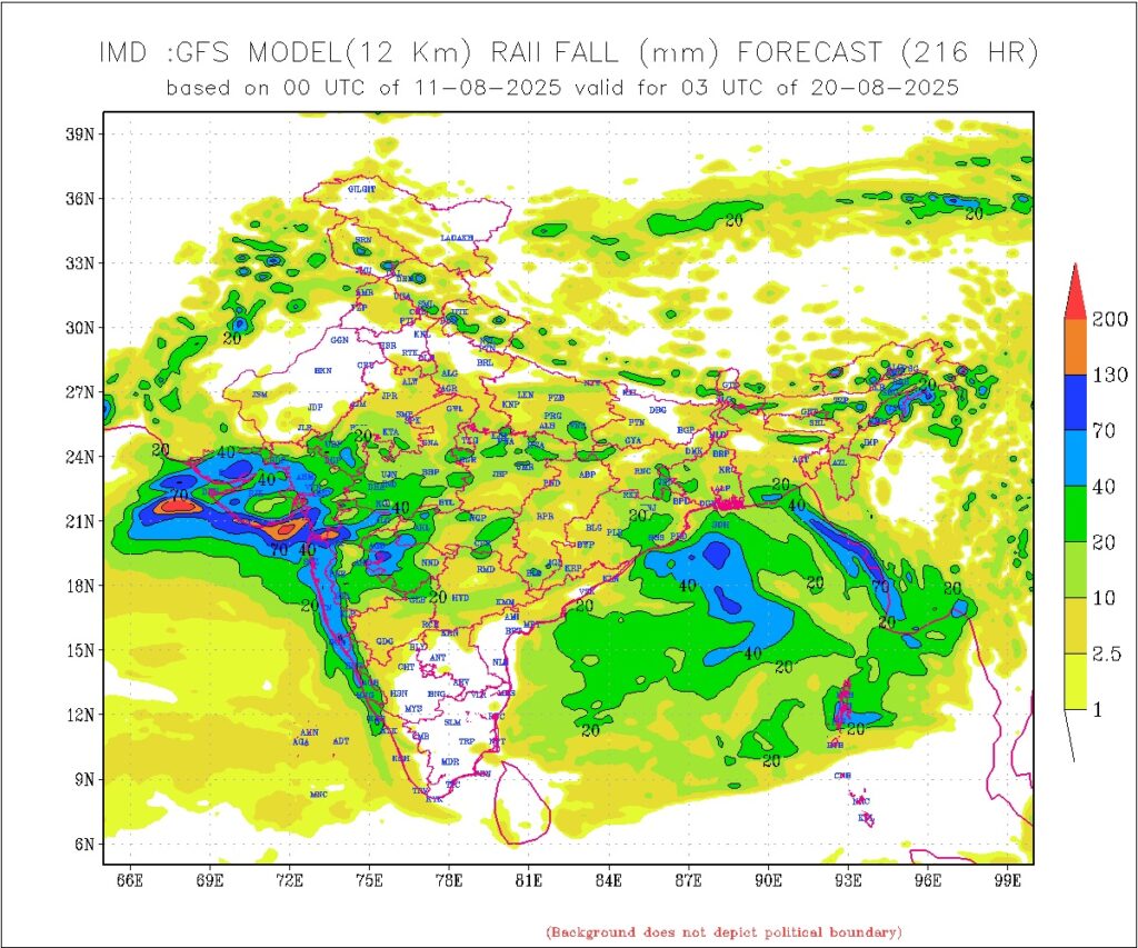
Rainfall Forecast for Saurashtra, Kutch & Gujarat
Period: 11th to 20th August 2025
-
Scattered showers/light/medium rain till 15th August.
-
Subsequently the rainfall amount and coverage will increase first over Gujarat Region and subsequently over Saurashtra & Kutch till 20th August, that is expected to give an overall a Widespread round over the whole Gujarat State.
-
The Rain quantum is dependent on the Bay of Bengal System and other potential weather parameters, update will be given after the System forms.
સૌરાષ્ટ્ર, કચ્છ અને ગુજરાતમાં 16થી 20 ઓગસ્ટ 2025 દરમિયાન વ્યાપક વરસાદ ના રાઉન્ડ ની શક્યતા
હાલની હવામાન સ્થિતિ – 11 August 2025
(0530 કલાક IST મુજબ)
મોન્સૂન ટ્રફ:
મીન સી લેવલ પર, તે અમૃતસર – પટિયાલા – બરેલી – લખનૌ – ગોરખપુર – પટણા – પુરનિયા પરથી પસાર થઈને પૂર્વોત્તર તરફ અરુણાચલ પ્રદેશ સુધી જાય છે.
અપર એર સાયક્લોનિક સરક્યુલેશન્સ:
- ઉત્તર કોસ્ટલ આંધ્ર પ્રદેશ અને લગોલગ તેલંગાણા — 3.1 થી 5.8 km મીન સી લેવલથી ઉપર, ઊંચાઈ સાથે દક્ષિણ તરફ ઢળતું.
- ઉત્તર પશ્ચિમ ઉત્તર પ્રદેશ — 3.1 km મીન સી લેવલ સુધી (મધ્ય ઉત્તર પ્રદેશથી ખસેલું).
- કચ્છ અને આસપાસનું વિસ્તારો — 3.1 km મીન સી લેવલ પર (ઉત્તરપૂર્વ અરબી સમુદ્ર અને લગોલગ ગુજરાતથી ખસેલું).
- ઉત્તર આંતરિક કર્ણાટક અને આસપાસનું વિસ્તારો — 4.5 થી 5.8 km મીન સી લેવલ ઉપર.
વેસ્ટર્ન ડિસ્ટર્બન્સ:
ઉત્તર પાકિસ્તાન અને આસપાસના વિસ્તારોમાં સાયક્લોનિક સરક્યુલેશન — 3.1 થી 5.8 km મીન સી લેવલ ઉપર.
લો-પ્રેશર એરિયા થવાની ની શક્યતા:
ઉત્તર પશ્ચિમ અને લગોલગ વેસ્ટ સેન્ટ્રલ બંગાળની ખાડીમાં 13 August 2025 આસપાસ બનવાની શક્યતા.
અપેક્ષિત હવામાન પરિમાણો
અનુમાન સમયગાળો: 11 – 20 August 2025
- MSLP (મીન સી લેવલ પ્રેશર)
- બંગાળની ખાડીનું સિસ્ટમ પશ્ચિમ-ઉત્તર પશ્ચિમ તરફ સેન્ટ્રલ ઇન્ડિયાની દિશામાં ખસવાની, ત્યારબાદ ગુજરાત રાજ્ય નજીક પહોંચવાની અને પછી અરબી સમુદ્ર તરફ જવાની શક્યતા.
- 925 hPa લેવલ (~0.75 km MSL ઉપર)
- 12 અને 13 August એ તિવ્ર પવનની શક્યતા.
- 850 hPa લેવલ (~1.5 km MSL ઉપર)
- આ લેવલ ની ધરી ની પશ્ચિમ શાખા 18 August આસપાસ તેની સામાન્ય સ્થિતિ નજીક રહેશે, ત્યારબાદ દક્ષિણ તરફ ખસશે.
- 700 hPa લેવલ (~3.1 km MSL ઉપર) – મુખ્ય સિનોપ્ટિક સ્તર
- યુએસી અને તેનો ટ્રફ ગુજરાત રાજ્ય, સિંધ અને ઉત્તરપૂર્વ અરબી સમુદ્ર પર/નજીક 15–16 August સુધી રહેવાની શક્યતા.
- બંગાળની ખાડીના સિસ્ટમ સાથે જોડાયેલ યુએસી 18–20 August વચ્ચે સેન્ટ્રલ ઇન્ડિયા તરફ અને પછી ગુજરાત રાજ્ય અને આસપાસ તરફ ખસવાની શક્યતા.
- ક્યારેક આ ફીચર આ સ્તરે વિસ્તૃત સાયક્લોનિક સરક્યુલેશન રૂપે દેખાશે.
- 500 hPa લેવલ (~5.8 km MSL ઉપર)
- પૂર્વ–પશ્ચિમ શિયર ઝોન પેનિન્સ્યુલર ઇન્ડિયા પર રહેવાની અને અનુમાન સમયગાળા દરમિયાન ઉત્તર તરફ ખસવાની શક્યતા.
- સમયગાળા ના અંતે તે 18°N થી 20°N સુધી પહોંચી શકે છે.
6. બંગાળની ખાડીની સિસ્ટમ
પશ્ચિમ-ઉત્તર પશ્ચિમ દિશામાં સેન્ટ્રલ ઇન્ડિયા તરફ અને ત્યારબાદ ગુજરાત રાજ્ય નજીક તથા અરબી સમુદ્ર તરફ ખસવાની શક્યતા.
સૌરાષ્ટ્ર, કચ્છ અને ગુજરાત માટે વરસાદનું અનુમાન
સમયગાળો: 11 – 20 August 2025
- 11 થી 15 August: છુટ્ટા છવાયા વિસ્તાર માં ઝાપટા હળવો માધ્યમ વરસાદ.
- ત્યારબાદ વરસાદનું પ્રમાણ અને વિસ્તાર વધશે. પહેલા ગુજરાત રિજિયનમાં વધશે અને ત્યારબાદ સૌરાષ્ટ્ર અને કચ્છમાં 20 August સુધી ફેલાશે, જે સમગ્ર ગુજરાત રાજ્યમાં વ્યાપક સંતોષકારક વરસાદ થવા ની શક્તયા છે
વરસાદનું પ્રમાણ બંગાળની ખાડીના સિસ્ટમ અને અન્ય સંભવિત હવામાન પરિમાણો પર આધારિત છે. સિસ્ટમ બન્યા પછી વરસાદ ની માત્રા ની અપડેટ આપવામાં આવશે.
-
⚠️ Advisory
Caution: Please refer/rely on IMD/RSMC Bulletins/Advisories for Storms & Weather related matter.
સાવચેતી: સ્ટોર્મ કે હવામાન અંગે ની માહિતી માટે ભારતીય હવામાન ખાતા/ગવર્મેન્ટ ના બુલેટીન/સુચના પર નિર્ભર રહેવું.
Read Comment Policy – કમેન્ટ માટે માર્ગદર્શન વાંચો
How To Upload Profile Picture For WordPress – વર્ડપ્રેસ માં પ્રોફાઈલ પિક્ચર કેમ રાખવું
Forecast In Akila Daily Dated 11th August 2025
Forecast In Sanj Samachar Daily Dated 11th August 2025