Southwest Monsoon Arrives Over Kerala & Parts of Karnataka – The Depression Over Coastal South Konkan Moving Eastwards Over Land
દક્ષિણ પશ્ચિમ ચોમાસું કેરળ અને કર્ણાટકના કેટલાક ભાગોમાં પ્રવેશી ગયું – દક્ષિણ કોકણ તટ પરનું ડિપ્રેશન પૂર્વ દિશામાં જમીન તરફ ખસી રહ્યું છે
24-05-2025 0600 UTC (11.30 am. IST)
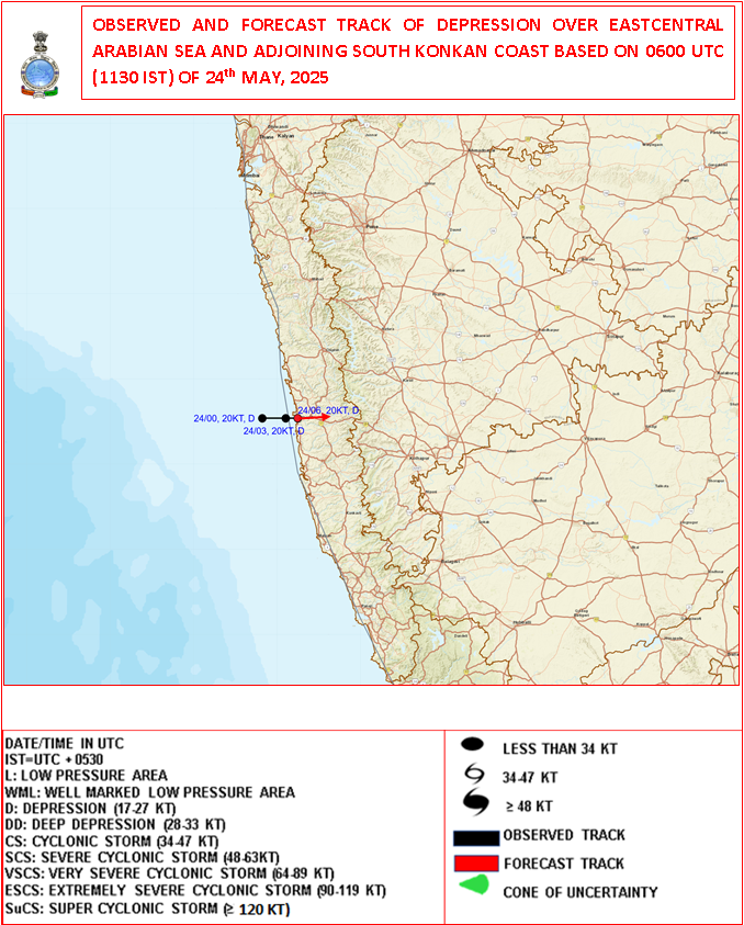
Observed and Forecast Track for Depression Over Arabian Sea
૨૪-૦૫-૨૦૨૫ 0600UTC (11.30 am. IST)
અરબી સમુદ્ર પર સર્જાયેલ ડિપ્રેશન માટે લીકેશન અને ટ્રેક ની આગાહી
-
Current Synoptic Conditions & Expected Weather Features
Date: 24 May 2025
The Depression over East Central Arabian Sea and adjoining south Konkan coast moved slowly eastward with a speed of 6 kmph during past 3 hours and lay centered at 0830 Hrs IST of today, the 24th May 2025 over the same region close to south Konkan coast near latitude 17.20 N & longitude 73.20 E, about 30 km north-northwest of Ratnagiri and 70 km south of Dapoli.
It is likely to continue to move nearly eastwards and cross south Konkan coast between Ratnagiri and Dapoli as a depression by noon of today, the 24th May 2025.
-
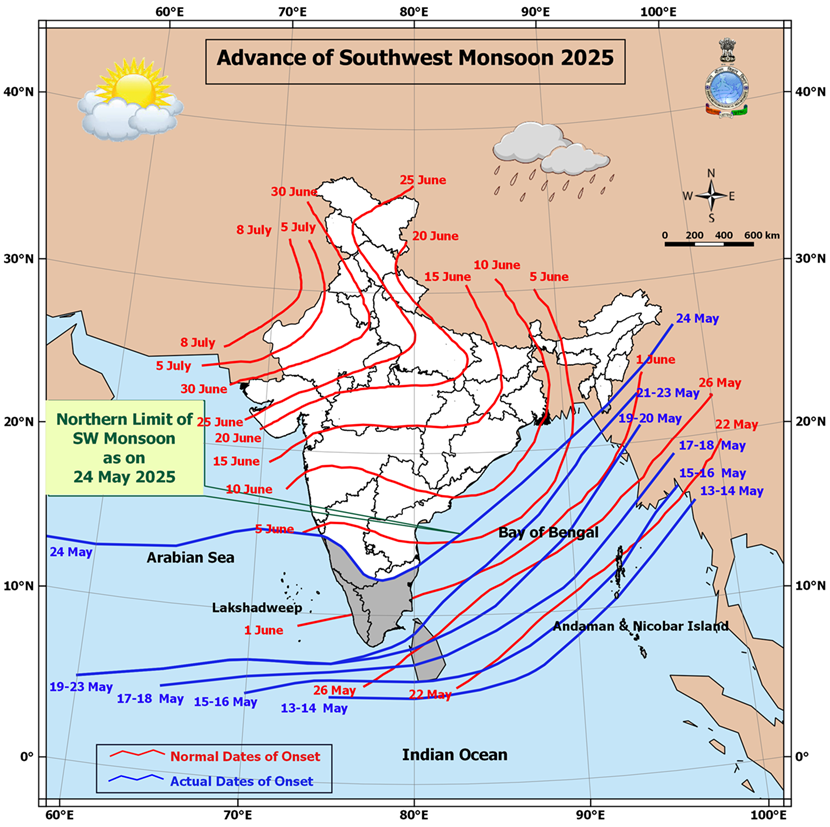
Southwest Monsoon Progress:
The Southwest Monsoon has further advanced into:
-
Remaining parts of south Arabian Sea
-
Parts of West central and East Central Arabian Sea
-
Entire Lakshadweep area, Kerala, and Mahe
-
Some parts of Karnataka
-
Remaining parts of Maldives and Comorin area
-
Many parts of Tamil Nadu
-
Remaining areas of southwest and eastcentral Bay of Bengal
-
Parts of West Central and North Bay of Bengal
-
Some parts of Mizoram
With this, the Southwest Monsoon has officially set in over Kerala today, 24th May 2025, which is ahead of its normal onset date of 1st June.
Northern Limit of Monsoon (NLM):
As of today, the NLM passes through the following coordinates and locations:
13°N/55°E – 13°N/60°E – 13.5°N/65°E – 15°N/70°E – Karwar – Shimoga – Dharmapuri – Chennai – 15°N/83°E – 18°N/87°E – Saiha – 25°N/96°E – 27°N/98°E
Outlook for Monsoon Advancement (Next 2–3 Days):
Conditions are favorable for further advancement of the Southwest Monsoon into:
-
More parts of the central Arabian Sea
-
Entire Goa
-
Some parts of Maharashtra and Andhra Pradesh
-
Additional areas of Karnataka and Tamil Nadu
-
More regions of West Central and North Bay of Bengal
-
Additional parts of the northeastern states
-
Some areas of Sub-Himalayan West Bengal and Sikkim
Trough Details:
-
A trough is currently extending from the the cyclonic circulation associated with the Depression over the South Konkan coast to south Madhya Maharashtra, south Marathwada, and north Telangana
-
This trough lies between 1.5 km and 3.1 km above mean sea level.
Low-Pressure Development Watch:
-
A new low-pressure area is likely to form over the West Central and adjoining north Bay of Bengal around 27th May.
-
Forecast for Gujarat, Saurashtra & Kutch (Up to 28th May 2025)
️ Wind Patterns:
-
Mainly Winds from West and Southwest and at times Variable winds.
-
Wind Speed: 15–20 km/h; gusts up to 20–30 km/h.
Very high gusts during thunder activity exceeding 50 km/hour
️ Sky Conditions:
-
Partly cloudy skies at times increased cloud cover.
️ Pre-Monsoon Activity:
-
Isolated to scattered rain expected over Saurashtra, Kutch & Gujarat region during 24th–28th May.
️
દક્ષિણ પશ્ચિમ ચોમાસું કેરળ અને કર્ણાટકના કેટલાક ભાગોમાં પ્રવેશી ગયું – દક્ષિણ કોકણ તટ પરનું ડિપ્રેશન પૂર્વ દિશામાં જમીન તરફ ખસી રહ્યું છે
️
️
વર્તમાન સિનોપ્ટિક સ્થિતિઓ અને અપેક્ષિત હવામાન લક્ષણો
તારીખ: 24 મે 2025
અરબ સાગરમાં ડિપ્રેશનની સ્થિતિ:
પૂર્વમધ્ય અરબ સાગર અને તે સાથે સંલગ્ન દક્ષિણ કોકણ તટ પર સર્જાયેલી ડિપ્રેશન છેલ્લા 3 કલાકમાં અંદાજે 6 કિમી પ્રતિ કલાકની ગતિએ ધીમે ધીમે પૂર્વ દિશામાં ખસેલી છે.
આજના 24 મે 2025ના રોજ ભારતીય માનક સમય મુજબ સવારે 8:30 વાગ્યે આ ડિપ્રેશન 17.2° ઉ.અ. અક્ષાંશ અને 73.2° પૂ.દે. રેખાંશ નજીક, દક્ષિણ કોકણ તટ પર રતનગિરિથી અંદાજે 30 કિમી ઉત્તર-ઉત્તરપશ્ચિમે અને દાપોલીથી 70 કિમી દક્ષિણમાં કેન્દ્રિત હતું.
આ સિસ્ટમની પૂર્વ દિશામાં ખસેલી રહી અને આજે બપોર સુધી રતનગિરિ અને દાપોલી વચ્ચે કોકણ તટને ડિપ્રેશન તરીકે પાર કરવાનો સંભવિત અંદાજ છે.
️ દક્ષિણ પશ્ચિમ ચોમાસાની પ્રગતિ:
દક્ષિણ પશ્ચિમ ચોમાસું હવે આગળ વધ્યું છે:
-
દક્ષિણ અરબ સાગરના બાકી રહેલા ભાગોમાં
-
પશ્ચિમમધ્ય અને પૂર્વમધ્ય અરબ સાગરના કેટલાક ભાગોમાં
-
આખા લક્ષદ્વીપ, કેરળ, અને મહે વિસ્તારમાં
-
કર્ણાટકના કેટલાક ભાગોમાં
-
માલદ્વીપ અને કુમોરીન વિસ્તારના બાકી ભાગોમાં
-
તમિલનાડુના ઘણા વિસ્તારોમાં
-
પશ્ચિમદક્ષિણ અને પૂર્વમધ્ય બંગાળની ખાડીના બાકી વિસ્તારોમાં
-
પશ્ચિમમધ્ય અને ઉત્તર બંગાળની ખાડીના કેટલાક ભાગોમાં
-
મિઝોરમના કેટલાક ભાગોમાં
આ સાથે, દક્ષિણ પશ્ચિમ ચોમાસું આજના રોજ, એટલે કે 24 મે 2025ના રોજ કેરળ પર સત્તાવાર રીતે પ્રવેશી ગયું છે, જે તેનું સામાન્ય આગમન દિવસ 1 જૂન કરતાં પહેલા છે.
ચોમાસાની ઉત્તરી સીમા (Northern Limit of Monsoon – NLM):
આજના રોજ ચોમાસાની ઉત્તરી સીમા નીચે દર્શાવેલી સ્થાનરેખાઓ અને સ્થળોથી પસાર થાય છે:
13°N/55°E – 13°N/60°E – 13.5°N/65°E – 15°N/70°E – કરવાર – શિમોગા – ધર્મપુરી – ચેન્નાઈ – 15°N/83°E – 18°N/87°E – સાઇહા – 25°N/96°E – 27°N/98°E
આગામી 2-3 દિવસ માટે ચોમાસાની આગળ વધવાની શક્યતા:
અગામી 2-3 દિવસોમાં દક્ષિણ પશ્ચિમ ચોમાસું આગળ વધવાની અનુકૂળ પરિસ્થિતિઓ નોંધાઈ રહી છે. ચોમાસું આગળ વધી શકે છે:
-
મધ્ય અરબ સાગરના વધુ વિસ્તારોમાં
-
આખા ગોવા વિસ્તારમાં
-
મહારાષ્ટ્ર અને આંધ્ર પ્રદેશના કેટલાક વિસ્તારોમાં
-
કર્ણાટક અને તમિલનાડુના વધુ વિસ્તારોમાં
-
પશ્ચિમમધ્ય અને ઉત્તર બંગાળની ખાડીના વધુ વિસ્તારોમાં
-
ઉત્તરપૂર્વ ભારતના વધારાના ભાગોમાં
-
સબ-હિમાલયન પશ્ચિમ બંગાળ અને સિક્કિમના કેટલાક ભાગોમાં
️ ત્રફ રેખાની વિગતો:
ડિપ્રેશન ડિપ્રેસન આનુસંગિક યુએસી દક્ષિણ કોકણ તટથી લઈને દક્ષિણ મધ્ય મહારાષ્ટ્ર, દક્ષિણ મરાઠવાડા અને ઉત્તર તેલંગાણા સુધી એક ત્રફ રેખા સર્જાઈ રહી છે. આ ત્રફ રેખા સમુદ્ર સપાટીથી 1.5 કિમીથી 3.1 કિમીની ઊંચાઈએ આવેલ છે.
ન્યુનતમ લો પ્રેસર વિસ્તાર પર નજર:
એક નવું લો પ્રેસર ક્ષેત્ર 27 મે આસપાસ મધ્ય પશ્ચિમ અને સંલગ્ન ઉત્તર બંગાળની ખાડીમાં વિકસી શકે છે.
ગુજરાત, સૌરાષ્ટ્ર અને કચ્છ માટે આગાહી (૨૮ મે ૨૦૨૫ સુધી)
પવનની દિશા અને ઝડપ:
-
મુખ્યત્વે પશ્ચિમ અને દક્ષિણપશ્ચિમ દિશાના પવન, ક્યારેક પવનની દિશામાં ફેરફાર.
-
પવનની ઝડપ ૧૫-૨૦ કિમી/કલાક, ત્યારે-ત્યારે ૨૦-૩૦ કિમી/કલાક સુધી ના ઝટકા ના પવનો.
- ગાજ વીજ સમયે અચાનક પવન સ્પીડ વધે અને ફરતા પવનો ની શક્યતા.
આકાશની સ્થિતિ:
-
ક્યારેક છુટા છવાયા વાદળ અને ક્યારેક આકાશ ઘેરાય.
પૂર્વ મોનસૂન પ્રવૃત્તિ:
-
૨4 થી ૨૮ મે દરમિયાન સૌરાષ્ટ્ર, કચ્છ અને ગુજરાતમાં સીમિત વિસ્તાર થી છુટા છવાયા વિસ્તાર માં પ્રિમોન્સૂન એક્ટિવિટી.
-
⚠️ Advisory
Caution: Please refer/rely on IMD/RSMC Bulletins/Advisories for Storms & Weather related matter.
સાવચેતી: સ્ટોર્મ કે હવામાન અંગે ની માહિતી માટે ભારતીય હવામાન ખાતા/ગવર્મેન્ટ ના બુલેટીન/સુચના પર નિર્ભર રહેવું.
Read Comment Policy – કમેન્ટ માટે માર્ગદર્શન વાંચો
How To Upload Profile Picture For WordPress – વર્ડપ્રેસ માં પ્રોફાઈલ પિક્ચર કેમ રાખવું
BAAKI Forecast In Akila Daily Dated 24th May 2025
BAAKI Forecast In Sanj Samachar Daily Dated 24th May 2025