Multiple Rounds of Rainfall Likely Over Saurashtra, Kutch & Gujarat: 21st–28th June 2025
સૌરાષ્ટ્ર, કચ્છ અને ગુજરાતમાં 21થી 28 જૂન 2025 દરમિયાન એકથી વધુ વખત વરસાદ ના રાઉન્ડ ની શક્યતા
Current Weather Conditions – 21st June 2025
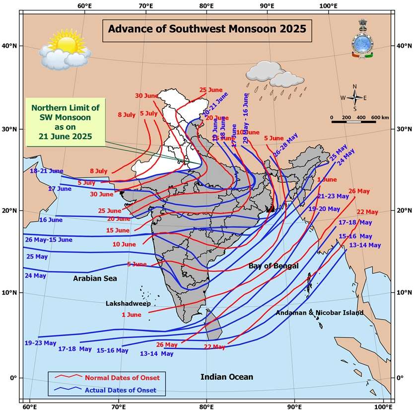
Northern Limit of Monsoon (NLM):
The NLM continues to pass through:
25.0°N/60.0°E, 25.0°N/65.0°E, 25.5°N/70.0°E, Jaipur, Agra, Rampur, Dehradun, Shimla, Manali, and 33.5°N/79.0°E.
Monsoon Progress Outlook:
-
Conditions are favorable for further advance of the Southwest Monsoon over:
-
Remaining parts of North Arabian Sea
-
Additional parts of Rajasthan
-
Remaining parts of West Uttar Pradesh, Uttarakhand, Himachal Pradesh
-
Some parts of Jammu & Kashmir, Gilgit-Baltistan, Muzaffarabad, and Ladakh
in the next 2 days
-
-
Further, conditions are becoming favorable for the monsoon to advance into:
-
Remaining parts of Jammu & Kashmir and Ladakh
-
Some parts of Punjab, Haryana, Chandigarh & Delhi
in the subsequent 2 days -
-
Synoptic Features
-
A Low Pressure Area lies over southwest Bihar & neighborhood, with an associated upper air cyclonic circulation tilting southward with height in the middle tropospheric levels.
It is expected to move slowly northwestward and weaken gradually over the next 12 hours. -
An upper air cyclonic circulation is present over northeast Rajasthan & neighborhood in the lower tropospheric levels.
-
A trough runs from northeast Bangladesh to south Gujarat, passing through:
-
The cyclonic circulation associated with the low pressure area over southwest Bihar
-
Central parts of Madhya Pradesh, in the lower tropospheric levels
-
Expected Weather Parameters
Forecast Period: 21st – 28th June 2025
MSLP (Mean Sea Level Pressure):
-
The off-shore trough along the South Gujarat to Kerala coast is expected to remain active on some days, enhancing monsoon activity.
925 hPa Level:
-
A monsoon low is expected to persist north of normal, remaining positioned over North India throughout the forecast period.
850 hPa Level:
-
An East-West shear zone or cyclonic circulation is likely to develop from East India towards Gujarat, influencing rainfall distribution and intensity.
700 hPa Level (Key Synoptic Layer):
-
22nd June: A broad cyclonic circulation is expected to extend from Bihar to Gujarat.
- Another upper air cyclonic circulation is likely to form over Gangetic West Bengal & neighborhood around 25th June.
-
26th June: The UAC over West Bengal is likely to track westward toward Gujarat. Broad Circulation expected.
-
By 26th/27th June: The broad circulation is expected to shrink and consolidate, becoming more concentrated near Madhya Pradesh and Gujarat.
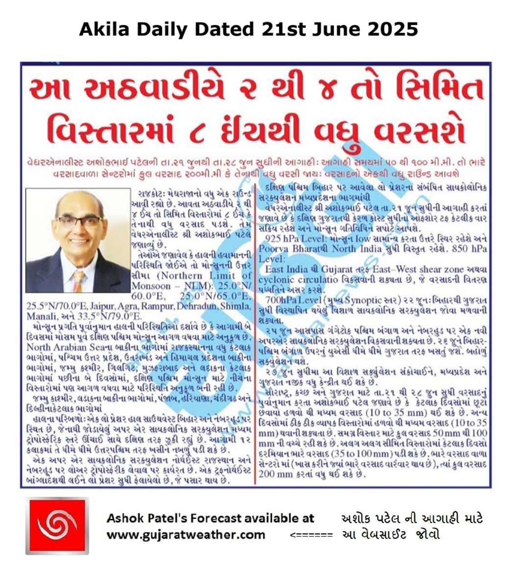
Rainfall Forecast for Saurashtra, Kutch & Gujarat
Period: 21st to 28th June 2025
-
On some days, light to moderate rainfall (10 to 35 mm) is expected over scattered areas.
-
On other days, fairly widespread rainfall (10 to 35 mm) is likely.
-
Cumulative rainfall during the forecast period may range from 50 mm to 100 mm over most areas (wide spread).
-
Isolated pockets may receive heavy rainfall (35 to 100 mm) on a few days.
-
At select locations, total rainfall could exceed 200 mm during the period, especially where such heavier spells occur.
સૌરાષ્ટ્ર, કચ્છ અને ગુજરાતમાં 21થી 28 જૂન 2025 દરમિયાન એકથી વધુ વખત વરસાદ ના રાઉન્ડ ની શક્યતા
હાલની હવામાન પરિસ્થિતિ – 21st June 2025
મોન્સૂનની ઉત્તર સીમા (Northern Limit of Monsoon – NLM):
NLM નીચેના સ્થળો પરથી પસાર થાય છે:
25.0°N/60.0°E, 25.0°N/65.0°E, 25.5°N/70.0°E, Jaipur, Agra, Rampur, Dehradun, Shimla, Manali, અને 33.5°N/79.0°E.
મોન્સૂન પ્રગતિ પૂર્વાનુમાન:
હાલની પરિસ્થિતિઓ દર્શાવે છે કે આગામી 2 દિવસમાં મોસમ પૂર્વ દક્ષિણ પશ્ચિમ મોન્સૂન આગળ વધવા માટે અનુકૂળ છે:
-
North Arabian Seaના બાકીના ભાગોમાં
-
Rajasthanના વધુ કેટલાક ભાગોમાં
-
West Uttar Pradesh, Uttarakhand, અને Himachal Pradeshના બાકીના ભાગોમાં
-
Jammu & Kashmir, Gilgit-Baltistan, Muzaffarabad, અને Ladakhના કેટલાક ભાગોમાં
પછીના 2 દિવસોમાં, દક્ષિણ પશ્ચિમ મોન્સૂન માટે નીચેના વિસ્તારોમાં પણ આગળ વધવા માટે પરિસ્થિતિ અનુકૂળ બની રહી છે:
-
Jammu & Kashmir અને Ladakhના બાકીના ભાગોમાં
-
Punjab, Haryana, Chandigarh & Delhiના કેટલાક ભાગોમાં
હાલ ના પરિબળો (Synoptic Features):
-
એક Low Pressure Area હાલ southwest Bihar & neighborhood પર સ્થિત છે, જેનાથી જોડાયેલું upper air cyclonic circulation મધ્યમ ટ્રોપોસ્ફેરિક સ્તરે ઊંચાઈ સાથે દક્ષિણ તરફ ઝૂકી રહ્યું છે.
આગામી 12 કલાકમાં તે ધીમે ધીમે ઉત્તરપશ્ચિમ તરફ ખસીને નબળું પડી શકે છે. -
એક upper air cyclonic circulation northeast Rajasthan & neighborhood પર lower tropospheric level પર કાર્યરત છે.
-
એક trough northeast Bangladeshથી લઈને south Gujarat સુધી ફેલાયેલો છે, જે પસાર થાય છે:
-
southwest Bihar પર આવેલા low pressure ના સંબંધિત cyclonic circulation
-
Madhya Pradeshના મધ્યભાગમાંથી
-
અપેક્ષિત હવામાન પરિબળો
અવધિ: 21st – 28th June 2025
MSLP (Mean Sea Level Pressure):
South Gujaratથી Kerala coast સુધીનો off-shore trough કેટલીક વાર સક્રિય રહેશે અને મોન્સૂન ગતિવિધિને સપોર્ટ આપશે.
925 hPa Level:
મોન્સૂન low સામાન્ય કરતા ઉત્તરે સ્થિર રહેશે અને Poorva Bharatથી North India સુધી વિસ્તૃત રહેશે.
850 hPa Level:
East India થી Gujarat તરફ East–West shear zone અથવા cyclonic circulation વિકસવાની શક્યતા છે, જે વરસાદની વિતરણ પધ્ધતિને અસર કરશે.
700 hPa Level (મુખ્ય Synoptic સ્તર):
-
22nd June: Bihar થી Gujarat સુધી વિસ્થાપિત થયેલું વિશાળ cyclonic circulation જોવા મળવાની શક્યતા.
- 25th June આસપાસ Gangetic West Bengal & neighborhood પર એક નવી upper air cyclonic circulation વિકસવાની શક્યતા છે.
-
26th June: Bihar/West Bengal ઉપરનું UAC ધીમે ધીમે Gujarat તરફ ખસતું જશે. બહોળું સર્ક્યુલેશન થશે.
-
27th June સુધીમાં: આ વિશાળ સર્ક્યુલેશન સંકોચાઈને, Madhya Pradesh અને Gujarat નજીક વધુ કેન્દ્રીત થઈ શકે છે.
Saurashtra, Kutch & Gujarat માટે વરસાદનું પૂર્વાનુમાન
અવધિ: 21st to 28th June 2025
-
કેટલાક દિવસોમાં છૂટો છવાયો હળવો થી મધ્યમ વરસાદ (10 to 35 mm) થઈ શકે છે.
-
અન્ય દિવસોમાં ઠીક ઠીક વ્યાપક વિસ્તારોમાં હળવો થી મધ્યમ વરસાદ (10 to 35 mm) થવાની શક્યતા છે.
-
સમગ્ર વિસ્તાર માટે કુલ વરસાદ 50 mm થી 100 mm ની વચ્ચે રહી શકે છે.
-
અલગ અલગ સીમિત વિસ્તારોમાં કેટલાક દિવસો દરમિયાન ભારે વરસાદ (35 to 100 mm) પડી શકે છે.
-
ભારે વરસાદ વાળા સેન્ટરો માં (ખાસ કરીને જ્યાં ભારે વરસાદ વારંવાર થાય છે), ત્યાં કુલ વરસાદ 200 mm કરતાં વધુ થઈ શકે છે.
-
⚠️ Advisory
Caution: Please refer/rely on IMD/RSMC Bulletins/Advisories for Storms & Weather related matter.
સાવચેતી: સ્ટોર્મ કે હવામાન અંગે ની માહિતી માટે ભારતીય હવામાન ખાતા/ગવર્મેન્ટ ના બુલેટીન/સુચના પર નિર્ભર રહેવું.
Read Comment Policy – કમેન્ટ માટે માર્ગદર્શન વાંચો
How To Upload Profile Picture For WordPress – વર્ડપ્રેસ માં પ્રોફાઈલ પિક્ચર કેમ રાખવું
Forecast In Akila Daily Dated 21st June 2025
Forecast In Sanj Samachar Daily Dated 21st June 2025
તારીખ 29 જુન 2025 આજની પરિસ્થિતિ ભારતીય હવામાન વિભાગ અનુસાર મીડ ડે બુલેટિન ➢ નૈઋત્ય નું ચોમાસુ આજે 29 જૂન 2025 ના રોજ રાજસ્થાન, પશ્ચિમ ઉત્તર પ્રદેશ અને હરિયાણાના બાકીના ભાગો અને સમગ્ર દિલ્હીમાં આગળ વધ્યું છે. આમ, તે 29 જૂન, 2025 ના રોજ સમગ્ર દેશને આવરી લે છે, જે સામાન્ય તારીખ 08 જુલાઈ (સમગ્ર ભારતને આવરી લેવાની સામાન્ય તારીખથી 9 દિવસ પહેલા) છે. ➢ લો પ્રેશર આજે 29 જૂન 2025 ના રોજ ભારતીય સમય મુજબ સવારે 08:30 વાગ્યે ઉત્તર પશ્ચિમ બંગાળની ખાડી અને તેની આસપાસના પશ્ચિમ બંગાળ અને બાંગ્લાદેશ દરિયાકાંઠા પર છે. તેનુ આનુષાંગિક UAC સરેરાશ સમુદ્ર સપાટીથી 7.6 કિમી… Read more »
sir monsoon axis kyare thase>?
Sajavey chhe. CHomasu aakha desh ma declare thay etle.
તારીખ 27 જુન 2025 આજની પરિસ્થિતિ ભારતીય હવામાન વિભાગ અનુસાર મીડ ડે બુલેટિન ➢ નૈઋત્ય ના ચોમાસાની રેખા 27.0°N/68.5°E, 27.0°N/70.0°E, જેસલમેર, બિકાનેર, ઝુનઝુનુ, ભરતપુર, રામપુર, સોનીપત, અનુપ નગર અને 29.0°N/70.0°E માંથી પસાર થાય છે. ➢ નૈઋત્ય નું ચોમાસું આગામી 2-3 દિવસ દરમિયાન દેશના બાકીના ભાગોમાં આગળ વધવા માટે પરિસ્થિતિઓ અનુકૂળ બની રહી છે. ➢ એક UAC દક્ષિણપશ્ચિમ રાજસ્થાન પર છે અને તે સરેરાશ સમુદ્ર સપાટીથી 5.8 કિમી સુધી વિસ્તરે છે જે વધતી ઊંચાઈ એ દક્ષિણપશ્ચિમ તરફ ઝુકાવ ધરાવે છે. ➢ પૂર્વ-પશ્ચિમ ટ્રફ દક્ષિણપશ્ચિમ રાજસ્થાન પર રહેલા ઉપરોક્ત UAC થી પૂર્વ રાજસ્થાન, ઉત્તર મધ્યપ્રદેશ, ઉત્તર ઝારખંડ, ગંગીય પશ્ચિમ બંગાળ માં થય… Read more »
Looks like Low forming around Arabian sea adjoining Saurashtra
Jamnagar ma nathi atyre
Ashok patel ni aagahi 21 to 28 june nni aaga hi hji chalu j 6e
*મન ના રથ ને માણસાઈ ની યાત્રા તરફ હાંકો,*
*એ જ સાચી રથયાત્રા.!*
અષાઢીબીજની શુભકામના.
બીજના રામ રામ……
Porbandar, dev bhumi dwarika, jamnagar, and kutch na mitro kaho varasad se k nahi na hoi to thay jase
Kalavad ma kai ch nahi bhai varsad
Ashok sir ni aagasi mujab ranavav ma 2 mast 2 2 ench na round aavi gaya..ek date 22 and second date 26 ma .haju vatavaran varsad mate positive chhe.thank you ashok sir for perfect prediction !
હવે વરાપ કેદી થી મળે એમ છે અમારે કપાસ બરે છે વાંકનેર માં બધાં થી જાજો વરસાદ અમારા આજુબાજુ ના વિસ્તાર માં છે
Supedi ma savarthi dhimidhare varsad chalu che
સર્વે કછી માડુ સર તથા ગૃપનાં સર્વે મિત્રોને અષાઢબીજ ની શુભકામનાઓ
asadhi bij ni sir Ane badha mitro ne subh kamana
કાલે રાત્રે અબડાસા લખપત વિસ્તારમાં સારા વરસાદ ના સમાચાર છે
વાતાવરણમાં બદલાવ આવ્યો છે અને લાસ્ટ 2 દિવસ બહુ જ બફારો હતો…28,29 ના વરસાદ આવી જાય તો સારું
Ashadhi bij na ashok sir and badha mitro ne ram ram
અષાઢી બીજ ના રામ રામ વેધર ગુરુ તથા બધા મિત્રો ને
Jay mataji sir…last 15 divas thi roj gajvij sathe varsad aave 6e…vavnilayak varsad thai gyo pan 2-4 kalak dhodhmar varsad pdvo joiye aevo varsad nthi padto roj hadvo madhyam varsad pde 6e hju man muki ne nthi varsato amari aaju baju na vistaroma saro varsad thai gyo pan aa vakhte amne hju baki rakhya 6e…
Same condition in Gandhinagar. Rainy weather is there with drizzling daily. But no good rains since last few days.
Dholka akkhi raat hadvo madhyam varsad
Surat ma pacho round ave avu sambhavna khari
Rajasthan kutch and Pakistan border par to bav Khatarnak thunder clouds banya lage chhe
સર
26/6/25
ઢસા વિસ્તાર મા આજનો વરસાદ
0.50 થી 3.00 ઇંચ
ઢસા જં 1/1.50 ઇંચ
જલાલપુર 3.00 ઇંચ
Sir, hu comment Karu Chu Tema tame reply aapo cho athva bija koi mitro, tenu notification nathi madtu to ky rite chalu Karu notification…?
Haal hu vyast chhu.
No problem, sir but free thav tiyyare jnavso…
80% શક્યતા બતાવતું હોય મોડેલ તો આપના મુજબ શક્યતા કેટલી…આજે સવાર માં એટલું બતાવતા મોડેલ પણ તડકો હતો
Model ma 80 percent shakyata batavtu hoy to actual ma varsad aavani shakyata 50 to 60 percent samajvi. Koi pan weather model fakt andaaj mate hoy che. Jyare jameen par pani pade tyarej sachu manvanu.
Sar aamare aagahino 2 raund salu
માળીયા હાટીના માં ખૂબ સારો વરસાદ આજે… 4થી 5 ઇંચ હશે.
700 hpa નો ચાટ જોતા આવતી 24 કલાક રાજકોટ જિલ્લામાં સારો વરસાદ થશે
3″varsad
Ajno 5.5 inch varasad
Gam:ghunada(khanapar)
Ta: Tankara
શ્રી અશોકભાઈ નમસ્તે! જય શ્રીકૃષ્ણ જય ઉમિયાજી
અમારે વડાળી લગભગ ત્રણ ઈંચથી વધારે વરસાદ થયેલ છે.નદી-નાળા તથા ખેતરોમાં ધોમ પાણી ગયા આજુબાજુ ગામડાંઓમાં પણ સારા વરસાદના વાવડ છે.
Pat na pat nathi upadto, tamara thi SSW 15km jabala mand bharana che till time!!!
Jsk mitro, As per forcast thik thik aavi jai che multiple round. 200 MM varu fix panu labh nathi aaptu …….
Junagadh Ane Junagadh ‘city’ na data ma gai kaale 3 mm no farak hoi, aaje tene ‘adjust’ karva Junagadh city na data ma 3 mm vadhari nakhya!
સર આવનારા 2 દિવસ બધા આગાહીકારો અને ન્યૂઝ વારા અતિભારે અને મેઘતાંડવ નું કહે છે તો સર સક્ય હોય તો આપ થોડી માહિતી આપો
Sarji dwarka baju kal thi varsad nu jor vadhi sake ? Amare haju aje japttu j bhag ma aviyu se. Koy khas varsad haju nathi aviyo. Please answer sarji.
Sarji dwarka baju kal thi varsad nu jor vadhi sake ? Haju japta sivay khas koy varsad nathi. Please answer sarji.
Ahmedabad Dholka
Zordar zhapta gajvij jode
Sir, amare toa first round ma j bhuka Kadhi nakha hata have japta padya rakhe.
Asadh mahino sharu thayo Ane Saurashtra ma vyapak varsad pan sharu thayo!
અમારે આજે સવારે વાદળછાયું પછી દસ વાગ્યા થી એક સુધી જોરદાર તડકો અને દોઢવાગ્યે થી એક કલાક મધ્યમ વરસાદ અને ફરી ચાર વાગ્યે પણ એક કલાક મધ્યમ વરસાદ અત્યારે બંધ છે .
Rainfall data update karo Last hours
બે ઈંચ વરસાદ પડયો હાલ અમારાથી પુર્વ દિશામાં ગાજવીજ થાઈ છે
ગોંડલ પંથક માં હજી વરસાદ નથી આવ્યો છાંટા આવે છે ખેડૂત વરસાદ ની રાહ જોઈ ને બેઠા છે બધે વરસાદ ચાલુ છે આયા જ નથી આવતો
Sir aaj 1 kalak thi saro varasad chalu Che.
Saro varsad ,
અમારે ધ્રોલ ની આસપાસના ગ્રામ્ય વિસ્તારમાં ચાર વાગ્યાથી ભારે વરસાદ પડી રહ્યો છે અત્યારે પણ ચાલુ છે અંદાજે બે ઇંચ વરસાદ હશે
Kadaka bhadaka sathe 2kalak thai haji chalu
Very good arjan ahir
Jam khambhaliya ane aaspaas ni vistar ma saro evo varsas chhe.
3.00 PM
1 thi 2 inch jevo
Hal pan chalu chhe .. 4 pm
Jsk સર… અમારે અને આજુબાજુ ના ગામડામાં 40 મિનિટ થી ધીમીધારે વરસાદ ચાલુ
Finally 45 mins ma 1.5 inch jevo varsad.. city ma
કેશોદ પંથક માં ૪ થી ૫ ઇંચ વરસાદ
Chotila ane aju baju na gam ma saro evo varsad avi gayo