Current Weather Conditions on 1st February 2013 @ 10.30 am.
The Temperature over Saurashtra, Gujarat and Kutch are 3 to 5 Degrees above normal for last three days. Yesterday’s Maximum and this morning Minimum Temperature over Rajkot, Ahmedabad, Surat & Bhuj are given along with normal Temperature for respective Cities.
Yesterday’s Maximum for Rajkot Max. 33.2 C & Morning Min. 17.3 C.
Normal for Rajkot is Max. 29 C & Min. 13 C.
Yesterday’s Maximum for Ahmedabad Max. 30.8 C & Morning Min. 16.7 C.
Normal for Ahmedabad is Max. 29 C & Min. 12 C.
Yesterday’s Maximum for Surat Max. 32.5 C & Morning Min. 17.5 C.
Normal for Surat Max. 30 C & Min. is 15 C.
Yesterday’s Maximum for Bhuj Max. 32.5 C & Morning Min. 16.3 C.
Normal for Bhuj Max. 27 C & Min. is 9 C.
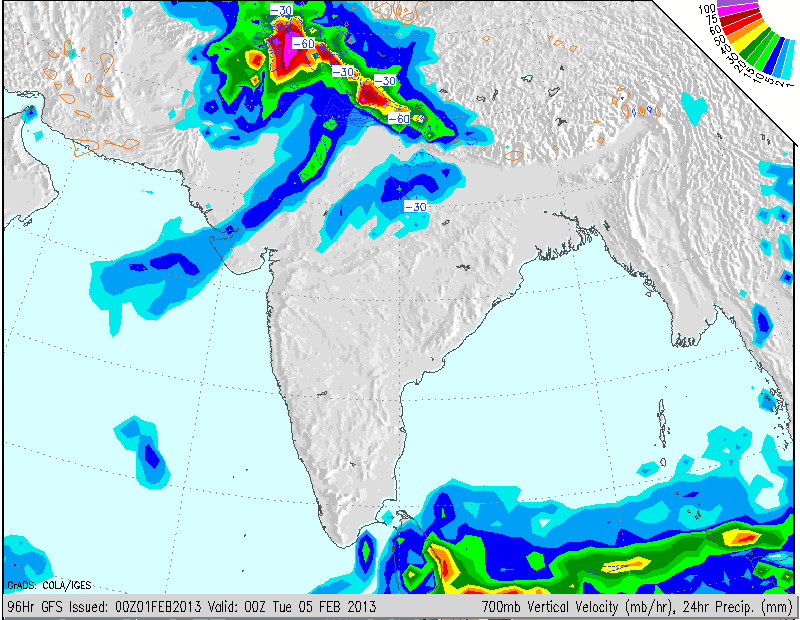
Forecast: Saurashtra, Gujarat & Kutch 1st to 6th February 2013
The winds are expected to be from varying directions during the next two days. Due to approaching Western Disturbance on 3rd February the winds will start to blow from the west from 3rd February Sunday. The humidity will increase and there is a possibility of fog on 4th and/or 5th February over some pockets of Kutch and Saurashtra. Cloudy conditions are expected during 4th and 5th February over Saurashtra, Kutch & North Gujarat with a possibility of unseasonal rain/showers over many places. WInds speeds will be high on 4th, 5th and 6th. The Maximum Temperatures will start declining from 4th and by 5th it will have come down by around 4 to 6 degrees C. thereby they will become below normal. Winter winds will start blowing from 6th February and the Minimum Temperature is expected to come down around 4 to 5 Degrees C. by 6th February.
North India: 1st to 6th February
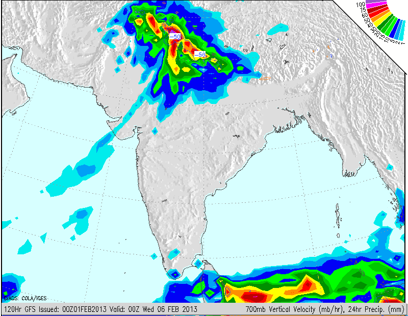
Strong Western Disturbance will approach over North India on 3rd initially Indo-Pak border area and subsequently will become stronger on 4th and 5th & 6th as it tracks Eastwards through most of North India. Heavy Snowfall is expected over hilly regions of Jammu & Kashmir, H.P., Uttrakhand and rainfall over lower regions of these States as well as over Punjab, Haryana, New Delhi, Uttar Pradesh and North Rajasthan mainly on 4th,5th & 6th Ferbuary. Scattered light snowfall and light rain is expected till 3rd February before the full blown Western Disturbance arrives.
Rainfall amount will vary from 1 Cm. to 10 Cms. as can be seen from COLA/IGES maps up to 5th and 6th morning.
Subsequent to the snowfall over the hilly regions on 4th,5th & 6th February, the estimated snowfall depth at some places are given below:
Srinagr 24 Cms.
Chamba 25 Cms.
Kupwara 55 Cms.
Ananatnag 35 Cms.
Kulu 20 Cms.
Uttarkashi 45 Cms.
Dharamshala 35 Cms.
Kishtwar 65 Cms.
Joshimadh 75 Cms.
Kyelang 160 Cms.
Weather Forecast in Akila Daily Dated 1st February 2013