Relief From Hot Weather Expected Over Saurashtra, Gujarat & Kutch – Maximum Temperatures Likely to Range Between 40°C and 43°C During 15th to 21st May 2026
સૌરાષ્ટ્ર, ગુજરાત અને કચ્છમાં ગરમીમાં રાહતની શક્યતા -15 મેથી 21 મે 2026 દરમિયાન મહત્તમ તાપમાન 40°C થી 43°C વચ્ચે રહેવાની સંભાવના
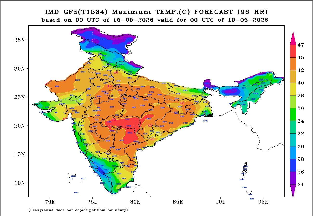
Gujarat Temperature Observations (14th May 2026)
Maximum temperatures on 14th May 2026 were around 2°C to 3°C above normal across most of the hot centers of Gujarat State.
- Rajkot: 43.1°C (2.3°C above normal)
- Deesa: 42.4°C (2.0°C above normal)
- Amreli: 42.9°C (2.1°C above normal)
- Ahmedabad: 43.7°C (2.1°C above normal)
- Vadodara: 43.2°C (3.1°C above normal)
- Bhuj: 40.6°C (1.5°C above normal)
Current Normal Maximum Temperature across most of Gujarat: 40.5°C to 41.5°C
Weather Forecast for Saurashtra, Gujarat & Kutch 15th to 21st May 2026
Wind Pattern
- Winds will predominantly remain Westerly.
- Wind Speed: 15–20 km/h up to 18th May, increasing to 20–30 km/h thereafter.
- Wind Gusts: 20–25 km/h up to 18th May, increasing to 25–35 km/h thereafter.
Sky Conditions
- Partly cloudy conditions are expected for the next two days.
- Skies will remain mostly clear on the remaining days.
Temperature Outlook
Maximum temperatures are expected to decrease by around 2°C to 3°C from recent levels, bringing noticeable relief from the recent hot weather.
- Most hot centers across Gujarat are likely to record maximum temperatures in the range of 40°C to 43°C on most days during the forecast period.
- Day-to-day fluctuations of 1°C to 3°C are likely.
- Most locations are expected to remain in the 40°C to 42°C range, while a few centers may occasionally reach the upper end of the forecast range near 43°C.
Summary
Relief from the recent hot weather is expected over Saurashtra, Gujarat, and Kutch during the next seven days.
Maximum temperatures are likely to remain mostly in the range of 40°C to 43°C, which is closer to seasonal normal levels and lower than the temperatures experienced during the past several days.
Relief From Hot Weather Expected Over Saurashtra, Gujarat & Kutch – Maximum Temperatures Likely to Range Between 40°C and 43°C During 15th to 21st May 2026
સૌરાષ્ટ્ર, ગુજરાત અને કચ્છમાં ગરમીમાં રાહતની શક્યતા -15 મેથી 21 મે 2026 દરમિયાન મહત્તમ તાપમાન 40°C થી 43°C વચ્ચે રહેવાની સંભાવના
ગુજરાતના તાપમાન અવલોકન (14 મે 2026)
14 મે 2026ના રોજ ગુજરાત રાજ્યના મોટા ભાગના ગરમ કેન્દ્રોમાં મહત્તમ તાપમાન નોર્મલ કરતાં આશરે 2°C થી 3°C વધુ નોંધાયું હતું.
- રાજકોટ: 43.1°C (નોર્મલ કરતાં 2.3°C વધુ)
- ડીસા: 42.4°C (નોર્મલ કરતાં 2.0°C વધુ)
- અમરેલી: 42.9°C (નોર્મલ કરતાં 2.1°C વધુ)
- અમદાવાદ: 43.7°C (નોર્મલ કરતાં 2.1°C વધુ)
- વડોદરા: 43.2°C (નોર્મલ કરતાં 3.1°C વધુ)
- ભુજ: 40.6°C (નોર્મલ કરતાં 1.5°C વધુ)
ગુજરાતના મોટા ભાગના વિસ્તારોમાં હાલનું નોર્મલ મહત્તમ તાપમાન: 40.5°C થી 41.5°C ગણાય.
સૌરાષ્ટ્ર, ગુજરાત અને કચ્છ માટે હવામાન આગાહી 15 મેથી 21 મે 2026
પવનની સ્થિતિ
- પવનો મુખ્યત્વે પશ્ચિમી દિશાના રહેશે.
- પવનની ઝડપ: 18 મે સુધી 15 થી 20 કિમી પ્રતિ કલાક, ત્યારબાદ 20 થી 30 કિમી પ્રતિ કલાક.
- પવનના ઝોકા: 18 મે સુધી 20 થી 25 કિમી પ્રતિ કલાક, ત્યારબાદ 25 થી 35 કિમી પ્રતિ કલાક.
આકાશની સ્થિતિ
- આગામી બે દિવસ દરમિયાન આકાશ આંશિક વાદળછાયું રહેવાની શક્યતા છે.
- ત્યારબાદના દિવસોમાં આકાશ મોટાભાગે ચોખ્ખું રહેશે.
તાપમાનનો અંદાજ
તાજેતરના સ્તર કરતાં મહત્તમ તાપમાનમાં આશરે 2°C થી 3°C ઘટાડો થવાની શક્યતા છે, જેના કારણે ગરમીમાં નોંધપાત્ર રાહત મળશે.
- ગુજરાતના મોટા ભાગના ગરમ કેન્દ્રોમાં આગાહી સમયગાળા દરમિયાન મોટાભાગના દિવસોમાં મહત્તમ તાપમાન 40°C થી 43°C વચ્ચે નોંધાવાની શક્યતા છે.
- દૈનિક ધોરણે 1°C થી 3°C જેટલી વધઘટ શક્ય છે.
- મોટા ભાગના વિસ્તારોમાં મહત્તમ તાપમાન 40°C થી 42°C વચ્ચે રહેશે, જ્યારે થોડાક કેન્દ્રોમાં ક્યારેક 43°C સુધી પહોંચી શકે છે.
સારાંશ
આગામી સાત દિવસ દરમિયાન સૌરાષ્ટ્ર, ગુજરાત અને કચ્છમાં ગરમીમાં રાહત મળવાની શક્યતા છે.
મહત્તમ તાપમાન મોટાભાગે 40°C થી 43°C વચ્ચે રહેવાની સંભાવના છે, જે મોસમી નોર્મલની નજીક રહેશે અને છેલ્લા કેટલાક દિવસોમાં અનુભવાયેલી વધુ ગરમીની તુલનામાં ઓછું રહેશે.
Caution: Please refer/rely on IMD/RSMC Bulletins/Advisories for Storms & Weather related matter.
સાવચેતી: સ્ટોર્મ કે હવામાન અંગે ની માહિતી માટે ભારતીય હવામાન ખાતા/ગવર્મેન્ટ ના બુલેટીન/સુચના પર નિર્ભર રહેવું.
Read Comment Policy – કમેન્ટ માટે માર્ગદર્શન વાંચો
How To Upload Profile Picture For WordPress – વર્ડપ્રેસ માં પ્રોફાઈલ પિક્ચર કેમ રાખવું
Forecast In Akila Daily Dated 15th May 2026
Forecast In Sanj Samachar Daily Dated 15th May 2026
Ok
તારીખ 20 મે 2026 આજની પરિસ્થિતિ ભારતીય હવામાન વિભાગ અનુસાર મીડ-ડે બુલેટિન – નૈઋત્ય ચોમાસાની ઉત્તર સીમા (Northern Limit of Monsoon) હાલ 6°N/70°E, 6°N/75°E, 7°N/80°E, 9°N/85°E, 12°N/90°E, 14°N/93°E, 16°N/96°E અને 17.5°N/98°E પરથી પસાર થાય છે. – આગામી 3 થી 4 દિવસ દરમિયાન દક્ષિણપૂર્વ અરબી સમુદ્રના વધુ કેટલાક ભાગો, કોમોરિન વિસ્તાર, દક્ષિણપશ્ચિમ અને દક્ષિણપૂર્વ બંગાળની ખાડીના વધુ ભાગો, આખો આંદામાન સમુદ્ર તથા મધ્યપૂર્વ બંગાળની ખાડીના વધુ કેટલાક વિસ્તારોમાં નૈઋત્ય ચોમાસું આગળ વધવા માટે પરિસ્થિતિ અનુકૂળ છે. – નૈઋત્ય ચોમાસું 26 મે આસપાસ કેરળમાં પ્રવેશ કરે તેવી શક્યતા છે, જેમાં મોડલની ભૂલ ± 4 દિવસ રહી શકે છે. – ઉત્તર પાકિસ્તાન અને… Read more »
Chella 3nek di thi jor pavano fukay che rate 🙂
Ane gai kale sari evi thndak hti rate 9 10 vagya thi j…bv mja aavi 🙂
તારીખ 19 મે 2026 આજની પરિસ્થિતિ ભારતીય હવામાન વિભાગ અનુસાર મીડ-ડે બુલેટિન – નૈઋત્ય ચોમાસાની ઉત્તર સીમા (Northern Limit of Monsoon) હાલ 6°N/70°E, 6°N/75°E, 7°N/80°E, 9°N/85°E, 12°N/90°E, 14°N/93°E, 16°N/96°E અને 17.5°N/98°E પરથી પસાર થાય છે. – આગામી 3 થી 4 દિવસ દરમિયાન દક્ષિણપૂર્વ અરબી સમુદ્ર, કોમોરિન વિસ્તાર, દક્ષિણપશ્ચિમ અને દક્ષિણપૂર્વ બંગાળની ખાડી, સમગ્ર આંદામાન સમુદ્ર તથા મધ્યપૂર્વ બંગાળની ખાડીના વધુ કેટલાક ભાગોમાં નૈઋત્ય ચોમાસું આગળ વધવા માટે પરિસ્થિતિ અનુકૂળ છે. – નૈઋત્ય ચોમાસું 26 મે આસપાસ કેરળમાં પ્રવેશ કરે તેવી શક્યતા છે, જેમાં મોડલની ભૂલ ± 4 દિવસ રહી શકે છે. – એક વેસ્ટર્ન ડિસ્ટર્બન્સ ઉત્તર પાકિસ્તાન અને આસપાસના જમ્મુ… Read more »
Sir amdavad ma to garni j garmi 6 vaddo moklo to pan chalse
Aaje thya che atyare thoda vaddo 🙂
Tamara gar upar j 6 vadad
Arabian sea ma Dar vakhte chomasa pehla system bne pachi Oman side jai etle bhej pan khechi jai ane Chomasa pavan ne Nabda pde model jota Atyare pn evu j lage che Arbi ni system Oman side jase.
તારીખ 18 મે 2026 આજની પરિસ્થિતિ ભારતીય હવામાન વિભાગ અનુસાર મીડ-ડે બુલેટિન – નૈઋત્યનું ચોમાસું આજે, 18 મે 2026ના રોજ દક્ષિણપૂર્વ અરબી સમુદ્રના વધુ કેટલાક ભાગો, કોમોરિન વિસ્તારના કેટલાક ભાગો, દક્ષિણપશ્ચિમ અને દક્ષિણપૂર્વ બંગાળની ખાડીના વધુ કેટલાક ભાગો, આંદામાન સમુદ્રના મોટાભાગના વિસ્તારો, સમગ્ર આંદામાન અને નિકોબાર ટાપુઓ તથા મધ્યપૂર્વ બંગાળની ખાડીના કેટલાક ભાગોમાં આગળ વધ્યું છે. – હાલમાં ચોમાસાની ઉત્તર સીમા (NLM) 6°N/70°E, 6°N/75°E, 7°N/80°E, 9°N/85°E, 12°N/90°E, 14°N/93°E, 16°N/96°E અને 17.5°N/98°E પરથી પસાર થાય છે. – આગામી 3-4 દિવસ દરમિયાન નૈઋત્યનું ચોમાસું દક્ષિણપૂર્વ અરબી સમુદ્રના વધુ કેટલાક ભાગો, કોમોરિન વિસ્તાર, દક્ષિણપશ્ચિમ તથા દક્ષિણપૂર્વ બંગાળની ખાડીના વધુ વિસ્તારો, આંદામાન સમુદ્રના બાકીના… Read more »
Sir monsoon pavano anukulta mate north india ma heatwave ketla divas revu joye ane ketla degree temperature revu joye?
Heat Wave etle normal thi 5 C vadhu athva 45 athva vadhu.
Evu jaruri nathi ke Heat wave j hovu joiye.
North India ma Garmi padey etle Tyan Jaminpar bahodu Heat Low ke (Seasonal Low) thay.
Etle Arabian Sea na Pavano Khenchay and set thay.
sir
aa badha super el-nino vatu kare chhe pan el-nino thava mate nino SST 3.4 index +0.5 three months rehevo joiye. haju 10may ye +0.52 nondhayal chhe to 10AAug.sudhi+0.5 hovu joiye.ane tya sudhi ma to apdu monsoon 60%puru thai gayu hase. to super el-nino kai rite???
Sansanati maate chhe. Puri vigat ni khabar na hoy.
Yogya time thashe update aapish
Wah sarash jawab aapiyo theks
Nova criteria of overlapping months is for declaring event i think , but some agency says atmospheric response may influence early if sst anomaly like +1 c or above ,specifically nino 3.4 for indian monsoon some seasonal model also says that like cfs and nmme
Ghadiya lagn nathi thata !
Pahela Jova nu Gothvay… Sagaay thaay….pachhi Lagn thaay and tyar baad parinam aavey !
Tyan sudhi ma Chomasu chalu thai gayu hoy.
mara Abhyas pramaney AUgust Mahino evo chhe ke ene EL Nino ke La Nina sathe kai leva deva nathi.
August Mahino Te teni masti ma Varashto hoy chhe. Aa chhela 100 Varash na abhyas nu taaran chhe.
Thank you sir for information on your experience and information on August
તારીખ : 17 મે 2026 આજની પરિસ્થિતિ ભારતીય હવામાન વિભાગ અનુસાર : – નૈઋત્યનું ચોમાસું આગળ વધી રહ્યું છે. હાલમાં ચોમાસાની ઉત્તર સીમા (Northern Limit of Monsoon) 5°N/75°E, 6°N/79°E, 8°N/85°E, 10.5°N/90°E, 13.5°N/95°E અને 15.5°N/98°E પરથી પસાર થાય છે. – આગામી 2 થી 3 દિવસ દરમિયાન દક્ષિણ-પૂર્વ અરબી સમુદ્ર, દક્ષિણ-પશ્ચિમ તથા દક્ષિણ-પૂર્વ બંગાળની ખાડી, આંદામાન ટાપુઓના બાકીના વિસ્તારો, આંદામાન સમુદ્ર તથા મધ્યપૂર્વ બંગાળની ખાડીના કેટલાક વધુ વિસ્તારોમાં નૈઋત્યનું ચોમાસું આગળ વધવા માટે પરિસ્થિતિ અનુકૂળ છે. – નૈઋત્યનું ચોમાસું 26 મે આસપાસ કેરળમાં પ્રવેશ કરે તેવી શક્યતા છે, જેમાં મોડલની ભૂલ ± 4 દિવસ રહી શકે છે. – દક્ષિણ-પશ્ચિમ બંગાળની ખાડી અને… Read more »
Monsoon -2026
Ahi link ma chhe. Map
Monsoon Onset Map
Sir 17 ane 18 may na roj tapaman thoduk unchu rese evu lagi rahyu che.
Sir aavta 7 divas ma chhata chhuti ni kevik sakyta chhe tal na ubhada chhe varva na baki chhe Lila chhe mahiti aajo sir jay dwarkadhish
Zadap rakhay. General aagahi samay pachhi ma activity dekhay.
તારીખ 16 મે 2026 ભારતીય હવામાન વિભાગ અનુસાર મીડ-ડે બુલેટિન – નૈઋત્યનું ચોમાસું 26 મે આસપાસ કેરળમાં પ્રવેશ કરે તેવી શક્યતા છે, જેમાં મોડલની ભૂલ ± 4 દિવસ રહી શકે છે. – નૈઋત્યનું ચોમાસું આજે, 16 મે 2026ના રોજ દક્ષિણ-પૂર્વ અરબી સમુદ્રના કેટલાક ભાગો, દક્ષિણ-પશ્ચિમ તથા દક્ષિણ-પૂર્વ બંગાળની ખાડીના કેટલાક ભાગો, આંદામાન સમુદ્રના મોટા ભાગો, સંપૂર્ણ નિકોબાર ટાપુઓ તથા શ્રી વિજયપુરમ સહિત આંદામાન ટાપુઓના કેટલાક ભાગોમાં આગળ વધ્યું છે. – ચોમાસાની ઉત્તર સીમા (Northern Limit of Monsoon) હાલ 5°N/75°E, 6°N/79°E, 8°N/85°E, 10.5°N/90°E, 13.5°N/95°E અને 15.5°N/98°Eમાંથી પસાર થાય છે. – છેલ્લા 2 દિવસ દરમિયાન: (a) નિકોબાર ટાપુઓ તથા આંદામાન ટાપુઓના આસપાસના… Read more »
હિટ લો અને સીઝનલ લો આ બનેય અલગ અલગ જ કે બનેય એકજ આ બનેય નું કામ સુ?
Chomasu chalu thay te pahela Heat low (garmi ne hisabe Low thay North india). te chomasu pavano set karey.
Tyar baad chomasu besi jaay etle Seasonal ow ke Chomasu dhari tarike kaam karey. (Je North rajasthan thi Odisha baju )
SAAHEB
agau yuvrajbhai vaghela e comment karel hati k thank you vali comment na temna vichar thi tamo sahmat chho pan thank you ni comments to haji chaluj chhe
Tamari vaat 100% chhe.
bey vikalp chhe. Mitro tevi comment na karey.
biju ke amuk time pachhi amalwari thodi strict karu.
Strict kro…public na samje baki.
સાહેબ કંઈક એવું સેટિંગ થઈ શકે કે થૅન્ક યુ અને આભાર વાળી કોમેન્ટ ઓટોમેટિક એક સંયુક્ત કૉમેન્ટમાં આવી જાય? તો કોમેન્ટ લોડ ઓછો થતા સ્ક્રોલ લાંબુ ન થાય.
જય મુરલીધર સાહેબ
છેલ્લા પાંચ દિવસથી દક્ષિણ પક્ષીમ તો ક્યારેક ઉતર પક્ષીમ નો પવન થોડોક વધુ ગતિ થી વાય છે એમાં પણ ગત ૧૩/૧૪ તારીખે તો મીની વાવાઝોડા જેવું હતું
તો આ શું ચોમાસું હવે નજદીકી સમય અથવા ચોમાસું સેટ થવા ના સંકેત કહેવાય
Dairya ma pavano haju set thay chhe.
North India ma haju Garmi vyavasthit nathi padi.
જય મુરલીધર સાહેબ
આજરોજ નેરુત્ય નું ચોમાસું આંદામાન નિકોબાર માં બેસી ગયું છે એવું આઈ એમ ડી દ્વારા જણાવવામાં આવ્યું છે
સેટેલાઇટ મા એના પ્રમાણે પુર્વ ભારત ના બીજા વિસ્તારોમાં પણ વાદળ સમુહ ઘણોખરો દેખાય છે
તો વિધીવત ચોમાસું કયા કયા પરિબળો ના આધારે નક્કી થાય છે સાહેબ?
Gai kale ahi Pratikbhai IMD Bulletin Gujarati ma aapel chhe, tema badhi chhanavat karel chhe IMD ye.
Te vancho 4 thi panch line chhe tema aa babat ni.
varsad chhe tyan, Pavano babat, OLR babat vigere
One more round of heatwave on 17th & 18th May as some centre’s max temp can reach upto 43 to 44 degrees. After that temp will start to gradually decreasing.
Heat Wave ni Vyakhya jovo
Sir , Arab sea ma current jova mariyo rahiyo che satellite img ma to have agad majboot system bani shake che k, wait & watch ?
Pahela South India ma Chomasu bese. Andaman Nicobar pachhi.
Koi pan System baney te 7 divas na MAP ma dekhay.
Monsoon likely to hit Andaman & Nicobar by tomorrow & likely to enter Kerala 5 days earlier i.e on 26th May as informed by IMD.
આ વર્ષે ગરમી કંઈક અલગ જ પડી છે, તાપમાન નો આંકડો ઉંચો નથી ગયો પણ ગરમી આ વર્ષે બોવ લાગી છે અને પરસેવો વળે એવી ગરમી વધુ રહી છે આપણે.
અને બીજું કે દર વર્ષે પાકિસ્તાન ના અમુક સેન્ટર અને રાજસ્થાન ના અમુક સેન્ટર માં 50 ડિગ્રી સુધી નું તાપમાન અને દિલ્હી, હરિયાણા અને યુપી માં 47 ડિગ્રી સુધી નું તાપમાન જોવા મળે છે પણ આ વર્ષે એવો સિનારિયો નથી થયો
Thanks sir
Jay mataji sir…atare amare hadvo varsad aavyo road bhina karya aevo…
Sar imd 2 wik ma kalar purani sans kevak .,,?
IMD 10 days chhe
Sir keral Karnataka pase tame mukela temprature chart ma tapman 26 thi 30 batave atu nichu Kem ? Te rajya to visuvvrut najik se.
Dariya kantha na vistar ma evu hoy. Andar na bhago ma vadhu hoy
Thanks, saheb
Southwest monsoon hit over kaeral 26 may(imd official)
સર જય શ્રીકૃષ્ણ આભાર અપડેટ બદલ સર ચોમાસાની વિગત લખીનહી આદામાબાર નિકોબાર મા 2 દિવસ મા ચોમાસાનુ આગમન થાશે …..
Kaale lagbhag declare karshe.
વાવાઝોડા ની વાતું થાય છે તે શું છે?
આવવાનું છે શું આપડે ગુજરાત મા?
Aagahi samay ma nathi dekhatu.
Vividdh model ma alag alag taran hoy.
Arabian Sea baju WMLP dekhay pachhi rakholu raakho.
Baaki Youtube joya rakho ~
Thank sir
Thanks
Thank sir
તારીખ 15 મે 2026 આજની પરિસ્થિતિ ભારતીય હવામાન વિભાગ અનુસાર મીડ ડે બુલેટિન નૈઋત્ય નું ચોમાસું 26 મે આસપાસ કેરળમાં પ્રવેશ કરે તેવી શક્યતા છે, જેમાં મોડલની ભૂલ ± 4 દિવસ રહી શકે છે. આગામી 24 કલાક દરમિયાન દક્ષિણ બંગાળની ખાડી, આંદામાન સમુદ્ર તથા આંદામાન અને નિકોબાર દ્વીપસમૂહના કેટલાક ભાગોમાં નૈઋત્ય નું ચોમાસું આગળ વધવા માટે પરિસ્થિતિ અનુકૂળ બની રહી છે. દક્ષિણ-પશ્ચિમ અને લાગુ મધ્યપશ્ચિમ બંગાળની ખાડી પરનુ વેલ માર્કડ લો-પ્રેશર વિસ્તાર આજે તા. 15 મે 2026ના રોજ સવારે 08:30 IST મુજબ યથાવત છે. તેની સાથે સંકળાયેલ સાયક્લોનિક સર્ક્યુલેશન સરેરાશ સમુદ્ર સપાટીથી 5.8 કિમી ઊંચાઈ સુધી ફેલાયેલું છે જે વધતી… Read more »
Abhar Saheb
Thanks sir for new apdet
Yes Ashok Sir, aaje noticeably down lage che Temp 🙂
Aam vyavasthit farak lage che last 4 5 di ni tulna ma 🙂
Mja mja 🙂