Current Weather Conditions On 15th June 2013 @ 2.00 pm.
The Low Pressure area has tracked towards Madhya Pradesh and is lying over Southeast Madhya Pradesh and neighborhood with associated Cyclonic Circulation now extends up to Mid-Troposheric level tilting Southwestwards with height.
The trough at mean sea level now runs from West Rajasthan to East Central Bay of
Bengal across East Rajasthan, West Madhya Pradesh, the Centre of the low pressure
area and North coastal Andhra Pradesh.
There is an off-shore trough at mean sea level from South Gujarat coast to North Kerala Coast.
The Cyclonic Circulation lies over Northeast Arabian Sea and parts of Saurashtra & Kutch.
From IMD:
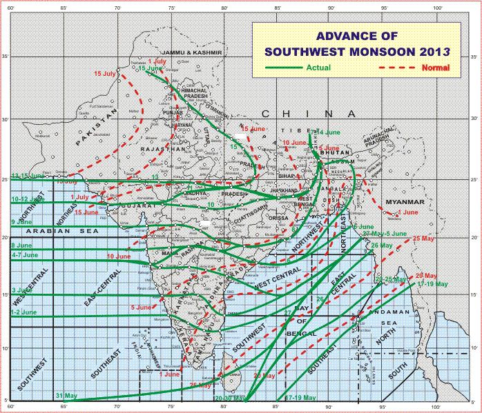
The Southwest Monsoon has further advanced into remaining parts of West
Bengal & Sikkim, Jharkhand, entire Bihar, Uttarakhand, Himachal Pradesh and
Jammu & Kashmir; some more parts of east Madhya Pradesh and some parts of
east Uttar Pradesh.
The Northern Limit of Monsoon (NLM) passes through Lat. 25° N / Long. 60° E,Lat. 25° N / Long. 65° E, Udaipur, Guna, Satna, Varanasi, Bahraich, Pantnagar,Dehradun, Una and Jammu.
IMD Map Of Advance Of Southwest Monsoon 2013
Forecast: up to 20th June
The Low Pressure was expected to track towards Southeast Rajasthan North Gujarat border area. However, latest forecast runs are showing that the Low Pressure and associated UAC will track over Central M.P. on 16th June and on 17th June will track Northwards towards North M.P. & U.P. border areas. Hence the quantum of rain forecast on 14th June for period up to 20th June may to go down in some areas of Gujarat & Saurashtra.
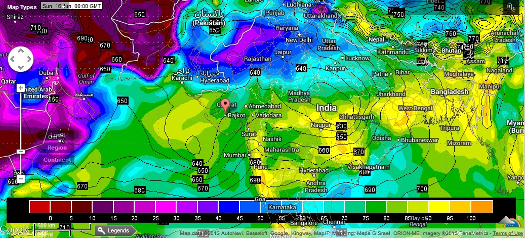
925 Mb. Chart shows the location of the System over Central M.P. on 16th June
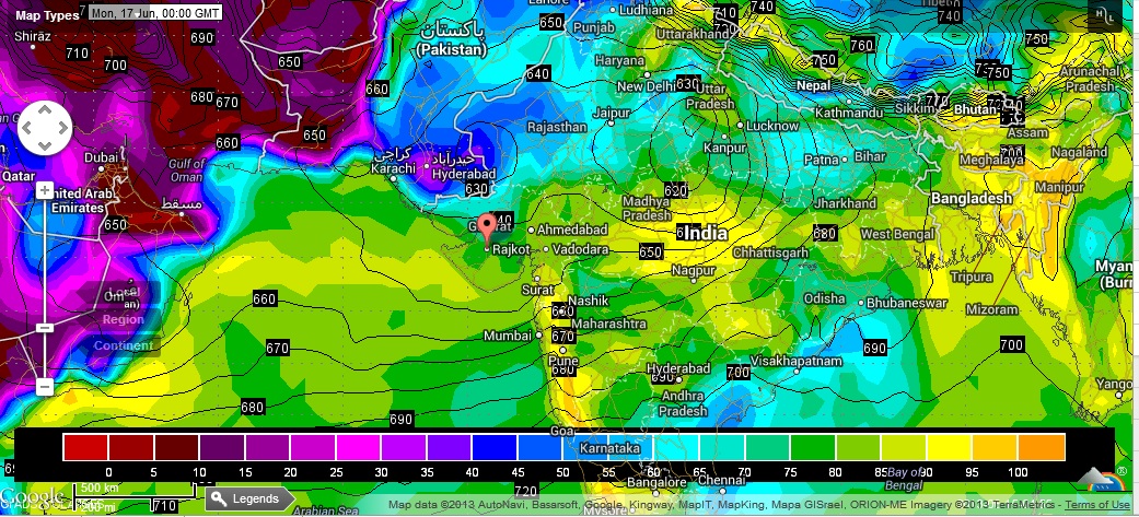
925 Mb. Chart shows the location of the System over North M.P. on 17th June
Weather Forecast In Akila Daily dated 15th June 2013 @ 2.00 pm.
sir lp is in west mp cloud are in arebian sea in morning image . we hope that rain is coiming sir we want to know that what will happnen when bob and arebian cloud meet and cloud direction is east west and rain coiming from west mostly in saurastra . sir I want to learn about forcast parameter .
Sif : Tamari vaat 100% sachi padi
Aaje
Gadhad..swamina.
Dist. Bhavnagar
Varshad 2″.thi 2.50.” Sudhi padyo sir…
Thenk you ….
sir lp is in west mp cloud are in arebian sea in morning image . we hope that rain is coiming sir we want to know that what will happnen when bob and arebian cloud meet and cloud direction is east west and rain coiming from west mostly in saurastra . sir I want to learn about forcast parameter .
Observe everything and see how it unfolds
sir 16th to 18th vachhe sauratra na tamam vistar ma varsad padche ke dariya katha vistar ma?
શાંતિ થી રાહ જોવો
Sir,kain samjanu nay. Saurastra ma m(porbandar) ma varsaad avse ke nay???
૧૬થિ ૧૮ માં થશે
sir tmd low pressuer map jota avu lagese ke system mp. thi up. tarf jay rahiche! to shuratra ma saro varsad padche ke nahi pade ?
arabian sea will give rain 16th to 18th vachhe
sir, lpa is in west mp say evening news of imd it is good for gujrat . inlast year it is not happened mostely so we can hope ?
Yes IMD says the LPA is over West M.P. but my forecast model shows differently.
Observe and see the result.